- Posts: 158
- Thank you received: 0
Baker south side reports?
- samthaman
- [samthaman]
-
 Topic Author
- Offline
- Junior Member
-

Less
More
15 May 2012 16:53 #205271
by samthaman
Baker south side reports? was created by samthaman
Anyone know where the snowline currently is? Are the sledders still active?
If the weather cooperates, I'm thinking of bringing my girlfriend and her friend up the south side this weekend, and I'd love to have a handle on how much of a road approach there will be.
Thanks in advance
sam
If the weather cooperates, I'm thinking of bringing my girlfriend and her friend up the south side this weekend, and I'd love to have a handle on how much of a road approach there will be.
Thanks in advance
sam
Please Log in or Create an account to join the conversation.
- nbsar
- [nbsar]
-
- Offline
- New Member
-

Less
More
- Posts: 9
- Thank you received: 0
15 May 2012 18:18 #205274
by nbsar
Replied by nbsar on topic Re: Baker south side reports?
There is snow to the final switchback. Baker has the best spring riding in Washington State, so expect lots of sledders until the Forrest Service says no more. You can sneak up the Sauk side where it is a little quieter, or go just about anywhere else above tree line, where sleds are not allowed.
Please Log in or Create an account to join the conversation.
- snoholic
- [snoholic]
-
- Offline
- Junior Member
-
Less
More
- Posts: 119
- Thank you received: 1
16 May 2012 08:01 #205282
by snoholic
Replied by snoholic on topic Re: Baker south side reports?
Saw sledders all the way up to the crater via the Easton on Friday. Is that legit?
Please Log in or Create an account to join the conversation.
- nbsar
- [nbsar]
-
- Offline
- New Member
-
Less
More
- Posts: 9
- Thank you received: 0
16 May 2012 12:04 #205287
by nbsar
Replied by nbsar on topic Re: Baker south side reports?
That is usually legit. You can check the wilderness boundary on the USGS map.
Please Log in or Create an account to join the conversation.
- Amar Andalkar
- [andalkar]
-
- Offline
- Premium Member
-

Less
More
- Posts: 635
- Thank you received: 0
16 May 2012 13:21 #205289
by Amar Andalkar
Wrong, it is never legit! Yes, you really should check the wilderness boundary on the USGS map. The legal snowmobile area goes nowhere near the crater, as the triangle of the Baker NRA tops out atop Sherman Peak.
Any snowmobile approaching the crater rim at the 9720 ft saddle west of Sherman Peak is more than 1500 ft inside the wilderness boundary. Even the large flat area where snowmobilers like to park and rest is over 600 ft inside the wilderness boundary.
See this map scanned from the official USFS Mount Baker Wilderness Map (2005) and annotated (originally posted in this TR: May 29, 2011, Mt Baker, Easton Above the Clouds ). The Wilderness boundary runs in a straight line from the cliffs which divide the Easton and Deming Glaciers up to the summit of Sherman Peak. This imaginary line is very easy to observe from any location above 7000 ft on the Easton or Deming, and any snowmobile seen to the west of this line is illegally trespassing.
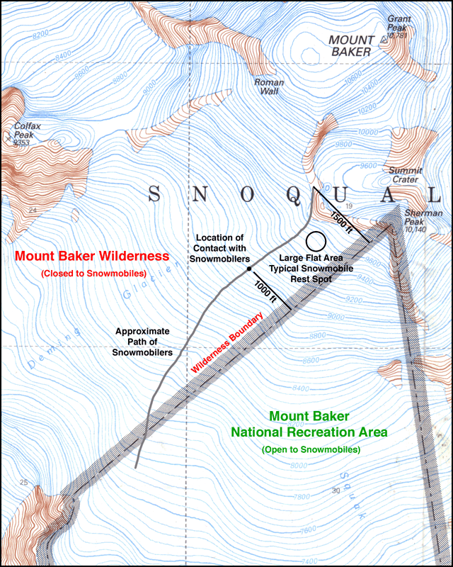
Everyone should be sick and tired of people driving their snowmobiles in illegal areas. If you want to go there, then park your snowmobile inside the legal area, and walk or ski over to the crater to take a look. Everyone has an equal right to go there, but just not with your vehicles.
Here is a Google map with all wilderness boundaries in the WA Cascades and eastern WA highlighted, zoomed in to show the south side of Baker:
www.mappingsupport.com/p/gmap4.php?q=htt...121.813913&t=t4&z=14
(if map fails to load, try again, it will work)
Replied by Amar Andalkar on topic Re: Baker south side reports?
Saw sledders all the way up to the crater via the Easton on Friday. Is that legit?
That is usually legit. You can check the wilderness boundary on the USGS map.
Wrong, it is never legit! Yes, you really should check the wilderness boundary on the USGS map. The legal snowmobile area goes nowhere near the crater, as the triangle of the Baker NRA tops out atop Sherman Peak.
Any snowmobile approaching the crater rim at the 9720 ft saddle west of Sherman Peak is more than 1500 ft inside the wilderness boundary. Even the large flat area where snowmobilers like to park and rest is over 600 ft inside the wilderness boundary.
See this map scanned from the official USFS Mount Baker Wilderness Map (2005) and annotated (originally posted in this TR: May 29, 2011, Mt Baker, Easton Above the Clouds ). The Wilderness boundary runs in a straight line from the cliffs which divide the Easton and Deming Glaciers up to the summit of Sherman Peak. This imaginary line is very easy to observe from any location above 7000 ft on the Easton or Deming, and any snowmobile seen to the west of this line is illegally trespassing.
Everyone should be sick and tired of people driving their snowmobiles in illegal areas. If you want to go there, then park your snowmobile inside the legal area, and walk or ski over to the crater to take a look. Everyone has an equal right to go there, but just not with your vehicles.
Here is a Google map with all wilderness boundaries in the WA Cascades and eastern WA highlighted, zoomed in to show the south side of Baker:
www.mappingsupport.com/p/gmap4.php?q=htt...121.813913&t=t4&z=14
(if map fails to load, try again, it will work)
Please Log in or Create an account to join the conversation.
- snoholic
- [snoholic]
-
- Offline
- Junior Member
-
Less
More
- Posts: 119
- Thank you received: 1
16 May 2012 14:15 #205290
by snoholic
Replied by snoholic on topic Re: Baker south side reports?
According the Amar's map the sledders I saw were out of the allowed area. They were right of to the rim of the crater / col between Sherman peak and the Roman. No climbers/skiers were on the Easton that day so I guess there was nobody around to annoy, but looking down from Grant peak is was a little suprising to see/hear sledders in that area.
Please Log in or Create an account to join the conversation.
- Good2Go
- [Good2Go]
-
- Offline
- Junior Member
-
Less
More
- Posts: 115
- Thank you received: 0
16 May 2012 14:49 #205292
by Good2Go
Replied by Good2Go on topic Re: Baker south side reports?
I'm not sure if the map posted by Amar is correct. It is certainly inconsistent with the map posted on the FS site (which clearly shows the crater at the top of the permitted zone): www.fs.usda.gov/recarea/mbs/recreation/r...recid=30330&actid=51
The FS is well aware that sledders have been riding all the way to the crater and parking in that exact spot (which is the only safe spot to park in that area) as they have been doing so for the last 30 years (at least). Pretty sure it's not illegal.
Amar's ability to identify an invisible boundary line rivals that of my sister in the back seat of the family wagon when we were on family vacations as kids. His sense of outrage is similar too.
Please Log in or Create an account to join the conversation.
- Amar Andalkar
- [andalkar]
-
- Offline
- Premium Member
-
Less
More
- Posts: 635
- Thank you received: 0
16 May 2012 15:30 #205294
by Amar Andalkar
Just because wilderness trespass has been ongoing for 30 years does not make it legal. If there isn't a flat spot to park snowmobiles within the legal NRA, then they should have thought of that when they lobbied to set the boundary decades ago. What they are doing is 100% illegal, but they are just not being ticketed or arrested or having their sleds confiscated. Yet. That time will certainly come, and much sooner than they want, if this constant wilderness trespass continues. Why don't they just stop doing this illegal activity instead?
I fail to see anything that qualifies as a navigational map on the page you linked. Are you talking about this map?:

You're joking, right? Please tell me so. You really think that "clearly shows the crater at the top of the permitted zone"?? You think someone's hand drawing (clearly marked "General location map, not to scale") shows the official boundary? Wow, just blown away by that, totally stunned that anyone could possibly think so.
The boundary on the map I posted is 100% correct, because I did not draw it myself, it is already drawn on the current USFS Mount Baker Wilderness Map that I scanned. The same exact boundary is shown on USGS topo maps.
I have no special ability to identify an invisible boundary line. But it's their own fault and lack of skill if they can't identify this particular invisible boundary line in the field, it requires only the desire to open their eyes and look. No GPS or anything else needed.
It is a straight line connecting two obvious, easily visible landmarks. All that anyone has to do is look up at Sherman Peak, then down towards the cliffs which divide the Easton and Deming Glaciers, and they will know instantly whether they are to the east or west of that line. Especially when they are parked on that flat spot, or over by the crater saddle, it is simply not possible to mistake where they are relative to this particular invisible boundary line, since those spots are SO FAR over the line.
Replied by Amar Andalkar on topic Re: Baker south side reports?
I'm not sure if the map posted by Amar is correct. It is certainly inconsistent with the map posted on the FS site (which clearly shows the crater at the top of the permitted zone): www.fs.usda.gov/recarea/mbs/recreation/r...recid=30330&actid=51
The FS is well aware that sledders have been riding all the way to the crater and parking in that exact spot (which is the only safe spot to park in that area) as they have been doing so for the last 30 years (at least). Pretty sure it's not illegal.
Amar's ability to identify an invisible boundary line rivals that of my sister in the back seat of the family wagon when we were on family vacations as kids. His sense of outrage is similar too.
Just because wilderness trespass has been ongoing for 30 years does not make it legal. If there isn't a flat spot to park snowmobiles within the legal NRA, then they should have thought of that when they lobbied to set the boundary decades ago. What they are doing is 100% illegal, but they are just not being ticketed or arrested or having their sleds confiscated. Yet. That time will certainly come, and much sooner than they want, if this constant wilderness trespass continues. Why don't they just stop doing this illegal activity instead?
I fail to see anything that qualifies as a navigational map on the page you linked. Are you talking about this map?:
You're joking, right? Please tell me so. You really think that "clearly shows the crater at the top of the permitted zone"?? You think someone's hand drawing (clearly marked "General location map, not to scale") shows the official boundary? Wow, just blown away by that, totally stunned that anyone could possibly think so.
The boundary on the map I posted is 100% correct, because I did not draw it myself, it is already drawn on the current USFS Mount Baker Wilderness Map that I scanned. The same exact boundary is shown on USGS topo maps.
I have no special ability to identify an invisible boundary line. But it's their own fault and lack of skill if they can't identify this particular invisible boundary line in the field, it requires only the desire to open their eyes and look. No GPS or anything else needed.
It is a straight line connecting two obvious, easily visible landmarks. All that anyone has to do is look up at Sherman Peak, then down towards the cliffs which divide the Easton and Deming Glaciers, and they will know instantly whether they are to the east or west of that line. Especially when they are parked on that flat spot, or over by the crater saddle, it is simply not possible to mistake where they are relative to this particular invisible boundary line, since those spots are SO FAR over the line.
Please Log in or Create an account to join the conversation.
- RossB
- [RossB]
-
- Offline
- Junior Member
-
Less
More
- Posts: 81
- Thank you received: 0
16 May 2012 16:43 #205296
by RossB
Replied by RossB on topic Re: Baker south side reports?
Great link Amar. I love the way GMap 4 displays USGS topo maps. You can switch between the various digital scanning of original topographic maps (topo high, topo low, etc.) as well as control the shading (I prefer to turn it off). As you might expect, regardless of how it was scanned, they all show the Wilderness boundary as you described it.
Please Log in or Create an account to join the conversation.
- Good2Go
- [Good2Go]
-
- Offline
- Junior Member
-
Less
More
- Posts: 115
- Thank you received: 0
16 May 2012 18:07 #205297
by Good2Go
Here are some indisputable facts Amar:
1. The sled community believes that it is legal to ride to the crater (including the clubs that interface w/ the FS all the time).
2. Sledders ride to the crater practically every day during the season (and have been for probably 30 years), not because they are negligent or intentional law breakers, but because they believe it is legal.
3. FS knows about this and does not object, even when it happens in their presence (e.g., at snomo club events that are also attended by the FS - which happens every year).
4. The FS posts a map on the page on their site dedicated to snomo rules on Baker and it shows the top of the mountain between the Roman Wall and Sherman Peak as within the legal zone (which just so happens to be the spot you are flagging as illegal).
That map may not be up to your lofty standards Amar, but the FS knows people will rely on it. (And if you think "official" maps are perfect you may want to look into the story of the Infinite Bliss climbing route controversy on Mt. Garfield.)
Please tell me you at least called the FS to confirm that it is illegal before coming on here to declare it "100% illegal". I'd be just blown away, totally stunned in fact, if an individual with your obvious attention to detail (based on your excellent trip reports) did something so reckless.
Replied by Good2Go on topic Re: Baker south side reports?
Just because wilderness trespass has been ongoing for 30 years does not make it legal. If there isn't a flat spot to park snowmobiles within the legal NRA, then they should have thought of that when they lobbied to set the boundary decades ago. What they are doing is 100% illegal, but they are just not being ticketed or arrested or having their sleds confiscated. Yet. That time will certainly come, and much sooner than they want, if this constant wilderness trespass continues. Why don't they just stop doing this illegal activity instead?
I fail to see anything that qualifies as a navigational map on the page you linked. Are you talking about this map?:
You're joking, right? Please tell me so. You really think that "clearly shows the crater at the top of the permitted zone"?? You think someone's hand drawing (clearly marked "General location map, not to scale") shows the official boundary? Wow, just blown away by that, totally stunned that anyone could possibly think so.
The boundary on the map I posted is 100% correct, because I did not draw it myself, it is already drawn on the current USFS Mount Baker Wilderness Map that I scanned. The same exact boundary is shown on USGS topo maps.
I have no special ability to identify an invisible boundary line. But it's their own fault and lack of skill if they can't identify this particular invisible boundary line in the field, it requires only the desire to open their eyes and look. No GPS or anything else needed.
It is a straight line connecting two obvious, easily visible landmarks. All that anyone has to do is look up at Sherman Peak, then down towards the cliffs which divide the Easton and Deming Glaciers, and they will know instantly whether they are to the east or west of that line. Especially when they are parked on that flat spot, or over by the crater saddle, it is simply not possible to mistake where they are relative to this particular invisible boundary line, since those spots are SO FAR over the line.
Here are some indisputable facts Amar:
1. The sled community believes that it is legal to ride to the crater (including the clubs that interface w/ the FS all the time).
2. Sledders ride to the crater practically every day during the season (and have been for probably 30 years), not because they are negligent or intentional law breakers, but because they believe it is legal.
3. FS knows about this and does not object, even when it happens in their presence (e.g., at snomo club events that are also attended by the FS - which happens every year).
4. The FS posts a map on the page on their site dedicated to snomo rules on Baker and it shows the top of the mountain between the Roman Wall and Sherman Peak as within the legal zone (which just so happens to be the spot you are flagging as illegal).
That map may not be up to your lofty standards Amar, but the FS knows people will rely on it. (And if you think "official" maps are perfect you may want to look into the story of the Infinite Bliss climbing route controversy on Mt. Garfield.)
Please tell me you at least called the FS to confirm that it is illegal before coming on here to declare it "100% illegal". I'd be just blown away, totally stunned in fact, if an individual with your obvious attention to detail (based on your excellent trip reports) did something so reckless.
Please Log in or Create an account to join the conversation.
- RossB
- [RossB]
-
- Offline
- Junior Member
-
Less
More
- Posts: 81
- Thank you received: 0
16 May 2012 19:18 #205298
by RossB
Replied by RossB on topic Re: Baker south side reports?
Where is the map you are talking about? The link you had earlier had a map, but we both assume you can't possibly be talking about that map. Please put a link to the map you are talking about. Every map I've looked at (which are all USGS maps, by the way) shows the border specified exactly as Amar says it is.
Here are some indisputable facts Amar:
4. The FS posts a map ...
Please Log in or Create an account to join the conversation.
- chmnyboy
- [chmnyboy]
-
- Offline
- Junior Member
-
Less
More
- Posts: 78
- Thank you received: 0
16 May 2012 19:31 #205299
by chmnyboy
Replied by chmnyboy on topic Re: Baker south side reports?
So, that about covers it for ya, eh Sam?
Please Log in or Create an account to join the conversation.
- samthaman
- [samthaman]
-
Topic Author
- Offline
- Junior Member
-
Less
More
- Posts: 158
- Thank you received: 0
16 May 2012 19:36 #205300
by samthaman
hehe, I guess I know where I can't ride my snowmobile now... though even that isn't clear.
Looks like the weather is putting baker on hold anyway... so all of this was for nothing!
Replied by samthaman on topic Re: Baker south side reports?
So, that about covers it for ya, eh Sam?
hehe, I guess I know where I can't ride my snowmobile now... though even that isn't clear.
Looks like the weather is putting baker on hold anyway... so all of this was for nothing!
Please Log in or Create an account to join the conversation.
- cumulus
- [cumulus]
-
- Offline
- Junior Member
-
Less
More
- Posts: 116
- Thank you received: 0
16 May 2012 23:36 - 17 May 2012 09:09 #205304
by cumulus
Replied by cumulus on topic Re: Baker south side reports?
well then, back to sno mo's...
(+ there's always the N side, no sno mos and skis real nice...

and pretty much car to car right about now with minor road travel)
like snoholic was saying, there was definitely a steady stream of loud whining to the steam vents:

As mentioned above this activity seems pretty well ingrained and - if it is illegal - out in the open. Check out all of Charlie McDowell's Youtube vids from the day of the pic above.
I think the crux of the problem is this very discussion. The fact that it's taking place. Which is primarily due to the lack of easily accessible and definitive information on what the boundaries are.
Seems to me anyone should be able to search: "Mt. Baker snowmobile boundaries" on their favorite search engine and come up with an answer pretty quickly. But you can't.
Why? I don't know. Obviously the FS hasn't made it a priority (posting clearly marked and easily accessible boundaries on the web would be a days work at most...)
(+ there's always the N side, no sno mos and skis real nice...
and pretty much car to car right about now with minor road travel)
like snoholic was saying, there was definitely a steady stream of loud whining to the steam vents:
As mentioned above this activity seems pretty well ingrained and - if it is illegal - out in the open. Check out all of Charlie McDowell's Youtube vids from the day of the pic above.
I think the crux of the problem is this very discussion. The fact that it's taking place. Which is primarily due to the lack of easily accessible and definitive information on what the boundaries are.
Seems to me anyone should be able to search: "Mt. Baker snowmobile boundaries" on their favorite search engine and come up with an answer pretty quickly. But you can't.
Why? I don't know. Obviously the FS hasn't made it a priority (posting clearly marked and easily accessible boundaries on the web would be a days work at most...)
Please Log in or Create an account to join the conversation.
- RossB
- [RossB]
-
- Offline
- Junior Member
-
Less
More
- Posts: 81
- Thank you received: 0
17 May 2012 11:42 #205306
by RossB
Replied by RossB on topic Re: Baker south side reports?
I agree. The Forest Service should basically restate the law (you can't use a snowmobile in a Wilderness area) and then link to an online USGS map. It wouldn't be that hard. Ideally it would be something like the GMap link listed above. The only problem with that is that you depend on GMap (or whoever) to stay around. The cheap and easy way to do it is to simply grab a jpeg and throw that on the server.Seems to me anyone should be able to search: "Mt. Baker snowmobile boundaries" on their favorite search engine and come up with an answer pretty quickly. But you can't.
Please Log in or Create an account to join the conversation.
- Micah
- [primate]
-
- Offline
- Moderator
-

Less
More
- Posts: 142
- Thank you received: 0
17 May 2012 12:02 #205307
by Micah
I agree that the FS is contributing to the problem (by posting vague descriptions that violators can hide behind), but it is not true that there is no easily accesible, definitive source for boundaries. As Amar has shown above, they are clearly marked on the USGS maps which are freely available on the internet and clearly show all wilderness boundaries. While the USGS maps are not free from errors, they are pretty damn good.
That the boundaries are not widely understood among the various recreation groups is clear. I remember a fairly recent example (perhaps on this site or maybe nwhikers; I'm too lazy to search) of a self-powered user with their panties in a wad b/c someone had taken their snowmobile past the wilderness boundary sign on the trail to the Park Butte lookout all the way to the lookout itself. The lookout is clearly outside the allowed area marked on the 'map' linked by Good2Go, but, in fact, the entire trail to the lookout is in the NRA and outside the wilderness, so the trip was legal and the sledders were on the correct side of the law.
I would point out to the sledders that the FS can not set or modify the boundaries. Their job, which they don't seem able to do well, is to manage the public lands including enforcing the boundaries. The boundaries are set by federal law. Just b/c an incompetent or unethical FS employee misrepresents the boundary, it does not follow that it is legal or ethical to ride in the wilderness. It's your responsibility to know and obey the law. I understand that there can be honest confusion, but this particular location has been discussed at length many times. The conflict is well known, and self-powered user can only assume that continuing incursions into the wilderness on the south side of Baker are willful violations of the law. If you want to sled to Park Butte lookout, I'm 100% on your side. If you want to sled in the Mt. Baker wilderness, I will wag my disapproving cyber-finger at you.
Replied by Micah on topic Re: Baker south side reports?
I think the crux of the problem is this very discussion. The fact that it's taking place. Which is primarily due to the lack of easily accessible and definitive information on what the boundaries are.
Seems to me anyone should be able to search: "Mt. Baker snowmobile boundaries" on their favorite search engine and come up with an answer pretty quickly. But you can't.
Why? I don't know. Obviously the FS hasn't made it a priority (posting clearly marked and easily accessible boundaries on the web would be a days work at most...)
I agree that the FS is contributing to the problem (by posting vague descriptions that violators can hide behind), but it is not true that there is no easily accesible, definitive source for boundaries. As Amar has shown above, they are clearly marked on the USGS maps which are freely available on the internet and clearly show all wilderness boundaries. While the USGS maps are not free from errors, they are pretty damn good.
That the boundaries are not widely understood among the various recreation groups is clear. I remember a fairly recent example (perhaps on this site or maybe nwhikers; I'm too lazy to search) of a self-powered user with their panties in a wad b/c someone had taken their snowmobile past the wilderness boundary sign on the trail to the Park Butte lookout all the way to the lookout itself. The lookout is clearly outside the allowed area marked on the 'map' linked by Good2Go, but, in fact, the entire trail to the lookout is in the NRA and outside the wilderness, so the trip was legal and the sledders were on the correct side of the law.
I would point out to the sledders that the FS can not set or modify the boundaries. Their job, which they don't seem able to do well, is to manage the public lands including enforcing the boundaries. The boundaries are set by federal law. Just b/c an incompetent or unethical FS employee misrepresents the boundary, it does not follow that it is legal or ethical to ride in the wilderness. It's your responsibility to know and obey the law. I understand that there can be honest confusion, but this particular location has been discussed at length many times. The conflict is well known, and self-powered user can only assume that continuing incursions into the wilderness on the south side of Baker are willful violations of the law. If you want to sled to Park Butte lookout, I'm 100% on your side. If you want to sled in the Mt. Baker wilderness, I will wag my disapproving cyber-finger at you.
Please Log in or Create an account to join the conversation.
- aaron_wright
- [aaron_wright]
-
- Offline
- Senior Member
-

Less
More
- Posts: 429
- Thank you received: 0
17 May 2012 13:08 #205309
by aaron_wright
Replied by aaron_wright on topic Re: Baker south side reports?
He did call the FS LEO and it is illegal. It's our responsibility to know the boundaries and respect them. Just because you believe something to be legal doesn't make it so. That's not how the world works.
Here are some indisputable facts Amar:
1. The sled community believes that it is legal to ride to the crater (including the clubs that interface w/ the FS all the time).
2. Sledders ride to the crater practically every day during the season (and have been for probably 30 years), not because they are negligent or intentional law breakers, but because they believe it is legal.
3. FS knows about this and does not object, even when it happens in their presence (e.g., at snomo club events that are also attended by the FS - which happens every year).
4. The FS posts a map on the page on their site dedicated to snomo rules on Baker and it shows the top of the mountain between the Roman Wall and Sherman Peak as within the legal zone (which just so happens to be the spot you are flagging as illegal).
That map may not be up to your lofty standards Amar, but the FS knows people will rely on it. (And if you think "official" maps are perfect you may want to look into the story of the Infinite Bliss climbing route controversy on Mt. Garfield.)
Please tell me you at least called the FS to confirm that it is illegal before coming on here to declare it "100% illegal". I'd be just blown away, totally stunned in fact, if an individual with your obvious attention to detail (based on your excellent trip reports) did something so reckless.
Please Log in or Create an account to join the conversation.
- cumulus
- [cumulus]
-
- Offline
- Junior Member
-
Less
More
- Posts: 116
- Thank you received: 0
17 May 2012 14:31 #205310
by cumulus
well, then try to find it - where is it?
Put yourself in the shoes of the average Joe (or Josephine). In good faith you try to find out where the boundaries are. You type: "Mt. Baker snowmobile boundaries" in your favorite search engine. You click on all 12 links on the first page, waste half an hour and come up empty handed. Sure there's lots of info stating "Snowmobiles are prohibited in Congressionally Designated Wilderness Areas." Great. But there's absolutely no practical or helpful information (map) clearly stating where the boundaries are.
What good is information if you can't find it?
So Josephine says f**k it, my friend Charlie sez the steam vents are really cool, I'm going to go check them out. Everybody else does. And off she goes.
Or maybe she's a little more diligent, perceptive and patient than the average Joe and tries searching for "Mt. Baker Wilderness Area boundaries". Still nothing.
What I'm driving at is that instead of this incessant kvetching about it - long thread about it last year too - why not work towards a solution?
As stated earlier, this information can be made much more accessible without too much trouble. If the Forest Service doesn't have a web person that can do it, have them get a hold of me. I'd be happy to spend a day freelancing to set up increased textual and image based SEO (search engine optimization) for "Mt. Baker snowmobile boundaries", "Mt. Baker Wilderness Area boundaries", and any derivatives thereof.
Replied by cumulus on topic Re: Baker south side reports?
but it is not true that there is no easily accesible, definitive source for boundaries
well, then try to find it - where is it?
Put yourself in the shoes of the average Joe (or Josephine). In good faith you try to find out where the boundaries are. You type: "Mt. Baker snowmobile boundaries" in your favorite search engine. You click on all 12 links on the first page, waste half an hour and come up empty handed. Sure there's lots of info stating "Snowmobiles are prohibited in Congressionally Designated Wilderness Areas." Great. But there's absolutely no practical or helpful information (map) clearly stating where the boundaries are.
What good is information if you can't find it?
So Josephine says f**k it, my friend Charlie sez the steam vents are really cool, I'm going to go check them out. Everybody else does. And off she goes.
Or maybe she's a little more diligent, perceptive and patient than the average Joe and tries searching for "Mt. Baker Wilderness Area boundaries". Still nothing.
What I'm driving at is that instead of this incessant kvetching about it - long thread about it last year too - why not work towards a solution?
As stated earlier, this information can be made much more accessible without too much trouble. If the Forest Service doesn't have a web person that can do it, have them get a hold of me. I'd be happy to spend a day freelancing to set up increased textual and image based SEO (search engine optimization) for "Mt. Baker snowmobile boundaries", "Mt. Baker Wilderness Area boundaries", and any derivatives thereof.
Please Log in or Create an account to join the conversation.
- RossB
- [RossB]
-
- Offline
- Junior Member
-
Less
More
- Posts: 81
- Thank you received: 0
17 May 2012 15:09 #205311
by RossB
Replied by RossB on topic Re: Baker south side reports?
I agree Cumulus, the Forest Service should do more. But the Wilderness Boundary is on the USGS map. If you head out in the wilds, shouldn't you have a map? I guess what I'm asking, are there good topo maps that don't have the Wilderness boundary? I'm not sure which scale maps have it, and which ones don't.
Please Log in or Create an account to join the conversation.
- T. Eastman
- [T. Eastman]
-
- Offline
- Senior Member
-
Less
More
- Posts: 288
- Thank you received: 0
17 May 2012 15:39 #205312
by T. Eastman
Replied by T. Eastman on topic Re: Baker south side reports?
A busy weekend's enforcement actions could do what gentler education approaches can't. $$$ yowza baby!
Please Log in or Create an account to join the conversation.
- aaron_wright
- [aaron_wright]
-
- Offline
- Senior Member
-
Less
More
- Posts: 429
- Thank you received: 0
17 May 2012 16:07 #205313
by aaron_wright
Replied by aaron_wright on topic Re: Baker south side reports?
If you type "Mt Baker NRA Baker Lake map" in google, you get a pdf www.nps.gov/noca/parknews/upload/Challenger%202007-7.pdf
that is the third result. That is what this area is called. The map, not a topo, shows the apex of the triangle at the top of Sherman Peak. This isn't that complicated. If that's not enough, go find a paper map and learn the boundaries. Why do people need to have every little thing laid out for them? What happened to personal responsibility?
that is the third result. That is what this area is called. The map, not a topo, shows the apex of the triangle at the top of Sherman Peak. This isn't that complicated. If that's not enough, go find a paper map and learn the boundaries. Why do people need to have every little thing laid out for them? What happened to personal responsibility?
Please Log in or Create an account to join the conversation.
- trees4me
- [trees4me]
-
- Offline
- Junior Member
-
Less
More
- Posts: 214
- Thank you received: 0
17 May 2012 20:01 #205316
by trees4me
Actually, due to consistent cuts to public outreach and enforcement, that's exactly how the world works.
Replied by trees4me on topic Re: Baker south side reports?
He did call the FS LEO and it is illegal. It's our responsibility to know the boundaries and respect them. Just because you believe something to be legal doesn't make it so. That's not how the world works.
Actually, due to consistent cuts to public outreach and enforcement, that's exactly how the world works.
really? you must be living in canada, eh? here in the USofA, it died a long long time ago.What happened to personal responsibility?
Please Log in or Create an account to join the conversation.
- davidG
- [davidG]
-
- Offline
- Elite Member
-

Less
More
- Posts: 764
- Thank you received: 0
17 May 2012 20:16 #205317
by davidG
that's a nice pic..
Replied by davidG on topic Re: Baker south side reports?
that's a nice pic..
Please Log in or Create an account to join the conversation.
- Amar Andalkar
- [andalkar]
-
- Offline
- Premium Member
-
Less
More
- Posts: 635
- Thank you received: 0
18 May 2012 18:08 #205327
by Amar Andalkar
As Aaron stated above (thanks!), I have spoken with the USFS law enforcement officer for Mt Baker Ranger District last June, and confirmed that the boundary is as shown on topo maps (i.e. the crater rim is well inside the wilderness, and illegal to snowmobile to).
So unfortunately, your "indisputable facts" are both disputed and not facts. The only thing which is not actually disputed is the location of the wilderness boundary, which is marked accurately on all available topographic and planimetric maps (USGS, USFS Mount Baker Wilderness, USFS Mount Baker-Snoqualmie National Forest, Green Trails, etc.), and is well known to the USFS and to all snowmobile groups (but clearly not known to many individuals who snowmobile). Still can not comprehend how you (or anyone) could possibly think that the hand-drawing you refer to (www.fs.usda.gov/Internet/FSE_MEDIA/fsbdev7_001285.gif) is some kind of official boundary map -- it is NOT at all, just look at any real topo map instead.
Based on what happened last May following that Baker TR (see May 29, 2011, Mt Baker, Easton Above the Clouds , and specifically reply #83 , where I detail at length my phone conversation with the USFS LEO), the USFS knows that the crater is off-limits to snowmobiles. The LEO never once disputed that the snowmobiles were illegally in the wilderness if they had gone to the crater. Only that I had not collected enough photographic evidence for the USFS to take the issue to court. Please read that post for details.
In addition, the "sled community" knows that it is NOT legal to ride to the crater, if by sled community you mean snowmobile clubs such as the one whose president contacted the USFS LEO after seeing my TR, worried about another potential black eye for snowmobilers and looking bad in public opinion. Those snowmobile clubs know full well that it is illegal to ride to the crater, and also illegal to ride to or park in that favorite lunch spot near 9500 ft. That's all inside the wilderness.
So your "indisputable facts" have now been shot full of holes. Except #3, which unfortunately is all too true. So let me restate them for you:
1. The sled community, as a whole, knows that it is NOT legal to ride to the crater (including the club president who contacted the USFS last year).
2. Sledders ride to the crater practically every day during the season because they are either negligent (don't know boundary), or they are intentional law breakers.
3. (true, very disappointing that some USFS employees behave this way and do not even raise a finger to object to illegal wilderness trespass)
4. The FS posts a hand-drawn map which some (like you) think is an official boundary map, while ignoring the correct boundary shown on topo maps including the 2005 USFS Mount Baker Wilderness map and USGS maps, and planimetric maps such as the USFS Mount Baker-Snoqualmie National Forest map.
Change is going to come to the south side of Mt Baker. Snowmobile riders will have to stop their illegal wilderness trespass, or some group like Wilderness Watch with deep pockets and plenty of lawyers is going to get pissed off, and take severe action.
Their solution will be simple: they will ignore the snowmobilers but instead sue the USFS in federal court, accusing the USFS of dereliction of its duty to enforce wilderness boundaries adjacent to the Mount Baker NRA. They will seek a temporary injunction demanding a full closure of the Mount Baker NRA to all snowmobiling to prevent irreparable harm to the adjoining wilderness, until such time as the USFS has clearly marked the wilderness boundary and is prepared to enforce it. They will most likely find a federal judge who is willing to grant such an injunction, too. The entire FR 12 road system accessing the NRA will then be closed to snowmobiling. By the time everything is sorted out in court over several years, the entire south side of Baker will have been closed to snowmobiles for all those years.
This will happen, unless the snowmobile community starts effective self-policing soon.
Replied by Amar Andalkar on topic Re: Baker south side reports?
Here are some indisputable facts Amar:
1. The sled community believes that it is legal to ride to the crater (including the clubs that interface w/ the FS all the time).
2. Sledders ride to the crater practically every day during the season (and have been for probably 30 years), not because they are negligent or intentional law breakers, but because they believe it is legal.
3. FS knows about this and does not object, even when it happens in their presence (e.g., at snomo club events that are also attended by the FS - which happens every year).
4. The FS posts a map on the page on their site dedicated to snomo rules on Baker and it shows the top of the mountain between the Roman Wall and Sherman Peak as within the legal zone (which just so happens to be the spot you are flagging as illegal).
That map may not be up to your lofty standards Amar, but the FS knows people will rely on it. (And if you think "official" maps are perfect you may want to look into the story of the Infinite Bliss climbing route controversy on Mt. Garfield.)
Please tell me you at least called the FS to confirm that it is illegal before coming on here to declare it "100% illegal". I'd be just blown away, totally stunned in fact, if an individual with your obvious attention to detail (based on your excellent trip reports) did something so reckless.
As Aaron stated above (thanks!), I have spoken with the USFS law enforcement officer for Mt Baker Ranger District last June, and confirmed that the boundary is as shown on topo maps (i.e. the crater rim is well inside the wilderness, and illegal to snowmobile to).
So unfortunately, your "indisputable facts" are both disputed and not facts. The only thing which is not actually disputed is the location of the wilderness boundary, which is marked accurately on all available topographic and planimetric maps (USGS, USFS Mount Baker Wilderness, USFS Mount Baker-Snoqualmie National Forest, Green Trails, etc.), and is well known to the USFS and to all snowmobile groups (but clearly not known to many individuals who snowmobile). Still can not comprehend how you (or anyone) could possibly think that the hand-drawing you refer to (www.fs.usda.gov/Internet/FSE_MEDIA/fsbdev7_001285.gif) is some kind of official boundary map -- it is NOT at all, just look at any real topo map instead.
Based on what happened last May following that Baker TR (see May 29, 2011, Mt Baker, Easton Above the Clouds , and specifically reply #83 , where I detail at length my phone conversation with the USFS LEO), the USFS knows that the crater is off-limits to snowmobiles. The LEO never once disputed that the snowmobiles were illegally in the wilderness if they had gone to the crater. Only that I had not collected enough photographic evidence for the USFS to take the issue to court. Please read that post for details.
In addition, the "sled community" knows that it is NOT legal to ride to the crater, if by sled community you mean snowmobile clubs such as the one whose president contacted the USFS LEO after seeing my TR, worried about another potential black eye for snowmobilers and looking bad in public opinion. Those snowmobile clubs know full well that it is illegal to ride to the crater, and also illegal to ride to or park in that favorite lunch spot near 9500 ft. That's all inside the wilderness.
So your "indisputable facts" have now been shot full of holes. Except #3, which unfortunately is all too true. So let me restate them for you:
1. The sled community, as a whole, knows that it is NOT legal to ride to the crater (including the club president who contacted the USFS last year).
2. Sledders ride to the crater practically every day during the season because they are either negligent (don't know boundary), or they are intentional law breakers.
3. (true, very disappointing that some USFS employees behave this way and do not even raise a finger to object to illegal wilderness trespass)
4. The FS posts a hand-drawn map which some (like you) think is an official boundary map, while ignoring the correct boundary shown on topo maps including the 2005 USFS Mount Baker Wilderness map and USGS maps, and planimetric maps such as the USFS Mount Baker-Snoqualmie National Forest map.
Change is going to come to the south side of Mt Baker. Snowmobile riders will have to stop their illegal wilderness trespass, or some group like Wilderness Watch with deep pockets and plenty of lawyers is going to get pissed off, and take severe action.
Their solution will be simple: they will ignore the snowmobilers but instead sue the USFS in federal court, accusing the USFS of dereliction of its duty to enforce wilderness boundaries adjacent to the Mount Baker NRA. They will seek a temporary injunction demanding a full closure of the Mount Baker NRA to all snowmobiling to prevent irreparable harm to the adjoining wilderness, until such time as the USFS has clearly marked the wilderness boundary and is prepared to enforce it. They will most likely find a federal judge who is willing to grant such an injunction, too. The entire FR 12 road system accessing the NRA will then be closed to snowmobiling. By the time everything is sorted out in court over several years, the entire south side of Baker will have been closed to snowmobiles for all those years.
This will happen, unless the snowmobile community starts effective self-policing soon.
Please Log in or Create an account to join the conversation.
- aaron_wright
- [aaron_wright]
-
- Offline
- Senior Member
-
Less
More
- Posts: 429
- Thank you received: 0
19 May 2012 06:17 #205328
by aaron_wright
Replied by aaron_wright on topic Re: Baker south side reports?
This going to happen and has already happened in other locations.Change is going to come to the south side of Mt Baker. Snowmobile riders will have to stop their illegal wilderness trespass, or some group like Wilderness Watch with deep pockets and plenty of lawyers is going to get pissed off, and take severe action.
Their solution will be simple: they will ignore the snowmobilers but instead sue the USFS in federal court, accusing the USFS of dereliction of its duty to enforce wilderness boundaries adjacent to the Mount Baker NRA. They will seek a temporary injunction demanding a full closure of the Mount Baker NRA to all snowmobiling to prevent irreparable harm to the adjoining wilderness, until such time as the USFS has clearly marked the wilderness boundary and is prepared to enforce it. They will most likely find a federal judge who is willing to grant such an injunction, too. The entire FR 12 road system accessing the NRA will then be closed to snowmobiling. By the time everything is sorted out in court over several years, the entire south side of Baker will have been closed to snowmobiles for all those years.
This will happen, unless the snowmobile community starts effective self-policing soon.
Please Log in or Create an account to join the conversation.
- nbsar
- [nbsar]
-
- Offline
- New Member
-
Less
More
- Posts: 9
- Thank you received: 0
19 May 2012 08:43 #205329
by nbsar
Replied by nbsar on topic Re: Baker south side reports?
Wow, you guys are a bundle of cheer.
Do we start a seperate thread on where all those sledders will ride when Baker is closed to them?
Do we start a seperate thread on where all those sledders will ride when Baker is closed to them?
Please Log in or Create an account to join the conversation.
- aaron_wright
- [aaron_wright]
-
- Offline
- Senior Member
-
Less
More
- Posts: 429
- Thank you received: 0
19 May 2012 11:07 #205331
by aaron_wright
Replied by aaron_wright on topic Re: Baker south side reports?
My guess is that snowmobiles will eventually be restricted to roads and a few play areas in clear cuts. This won't happen because of whining skiers, but from lawsuits brought by larger environmental non-profits forcing the FS to address the non management of snowmobiles on FS lands. It will be easier for them to just restrict them to snow covered roads than deal with off trail travel. Kind of like they do with other OHVs. I'll bet money this will happen in 10-15 years.Wow, you guys are a bundle of cheer.
Do we start a seperate thread on where all those sledders will ride when Baker is closed to them?
Please Log in or Create an account to join the conversation.
- hurleyboarder21
- [hurleyboarder21]
-
- Offline
- New Member
-
Less
More
- Posts: 10
- Thank you received: 0
21 May 2012 19:08 #205350
by hurleyboarder21
Replied by hurleyboarder21 on topic Re: Baker south side reports?
it may do some good to close the road up to schribers from the baker lake hiway for a couple of years!
The road maintenance that keeps that road open is mostly done by the local snomo club since the forest service does not have the funds.
look into it! bridge building, tree removal grading! much has been done by the snomo guys to keep it open.
oh ya the grooming.
maybe just close the gate at the blh for a couple of years so we can all appreciate learn to live together
Please Log in or Create an account to join the conversation.