Jan 6, 2008, - Avalanche above Paradise
1/6/08
WA Cascades West Slopes South (Mt Rainier)
20472
29
I thought the backcountry travelers that frequent Paradise might be interested in seeing the natural - non human triggered - avalanche photos I took on Sunday. The weather broke briefly in the afternoon and lit up the slopes above the Inn.
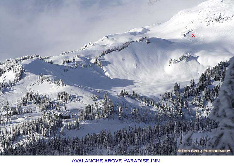
Shot from over on the Tatoosh?
Did you see it happen? Maybe windloaded?
ron j-
Yep, I was over in the Tatoosh.
Rusty Knees-
Yes, 100% windloaded.
I have a question for all of you avalanche students. Why did the above slope slide and the rest of the obvious avy slopes around it not slide?
Yep, I was over in the Tatoosh.
Rusty Knees-
Yes, 100% windloaded.
I have a question for all of you avalanche students. Why did the above slope slide and the rest of the obvious avy slopes around it not slide?
author=bc_skier link=topic=8735.msg35084#msg35084 date=1199854918]
I have a question for all of you avalanche students. Why did the above slope slide and the rest of the obvious avy slopes around it not slide?
:) Ah, such a simple question.
So many possible answers; for such a mysterious science.
To he who can answer that question with absolute certainty and factual accuracy lies the ability to save untold lives and possibly lifelong wealth.
My guess would lie with the trigger; possibly a kerplop off the trees above??
I'm assuming that slid on the New Years crust. Was that a surface hoar layer? Maybe the wind was able to get to some of those other areas and blow it off before that snow came. That patch looks like it might be a bit protected.
The cornices on the ridge to lookers left tell me that the slopes that broke were cross loaded. Perhaps an earlier wind scoured those slopes to a crust, but the cross loading itself would have kept me off that aspect.
Is that south facing? A little bit of sun warming the trees and rocks?
Extra snow accumulation in that area due to the trees on the windward side slowing the velocity of blowing snow and allowing it to accumulate there. None of the other potential avy slopes in the photo have as many small trees that close to the slope.
I'm curious ... the main slope/route leading up to Pan Point is more or less just "above" (from photo's perspective) the slide area, correct? (Looker's left of the tree patch?) And so the top of Pan Point would be just beyond the upper-right corner of photo?
I've only been to Pan Point about ten times in my life, so am not totally familiar with the terrain there.
I've only been to Pan Point about ten times in my life, so am not totally familiar with the terrain there.
Here's another vote for the wind theory...large cornices often form on the east side of those trees as well...the Pan Pt 'winter route' and commonly used SW face route are just above the AV...
The Dec 18 fatality was in the shaded gully 1/3 mile left in the larger view...think I'll stay off east through north aspects until we after we have another slice of Pineapple...
Paradise has been getting a foot per day for days...even strong trail-breakers should plan on about one mile per hour...
The Dec 18 fatality was in the shaded gully 1/3 mile left in the larger view...think I'll stay off east through north aspects until we after we have another slice of Pineapple...
Paradise has been getting a foot per day for days...even strong trail-breakers should plan on about one mile per hour...
How much snow has paradise gotten this season compared to Baker? Last year southern peaks like adams had poor seasons, much more so than further north. This year that doesn't appear to be the case. Any numbers out there?
As of Jan 1:
CURRENT CLIMATE PER CENT LAST THRU 2007 THRU 2007
DEPTH AVERAGE OF NORMAL YEAR MAX/YEAR MIN/YEAR
MT BAKER 112 88 127 130 190/1949 1/1928
PARADISE 117 91 129 101 163/1969 20/1977
Seems like the latest storms have pounded the volcanos, but not so much in the passes.
CURRENT CLIMATE PER CENT LAST THRU 2007 THRU 2007
DEPTH AVERAGE OF NORMAL YEAR MAX/YEAR MIN/YEAR
MT BAKER 112 88 127 130 190/1949 1/1928
PARADISE 117 91 129 101 163/1969 20/1977
Seems like the latest storms have pounded the volcanos, but not so much in the passes.
author=vogtski link=topic=8735.msg35110#msg35110 date=1199923486]
the Pan Pt 'winter route' and commonly used SW face route are just above the AV...
Doesn't the "winter route" ascend the minor crest (studded with small trees) that the slide in the picture starts from? I've always assumed that's what the term "winter route" refers to, but I wasn't certain. I remember Ray Smutek describing this route when I took his avalanche class long ago.
The Dec 18 fatality was in the shaded gully 1/3 mile left in the larger view...think I'll stay off east through north aspects until we after we have another slice of Pineapple...
Thanks for the clarification. That's sort of what I figured.
Another thought about why that little pocket failed while nothing around it did--the trees at the top of the slide provided a "perforation" which weakened the attachment of the slab to the ridgeline above. That's a concept that Ray Smutek used to talk about, as I recall.
Also, in the enlarged picture, the snowpack looks pretty thin right at the point where the slab pulled away from the trees. You might have some faceting there, again weakening the slab right at the top.
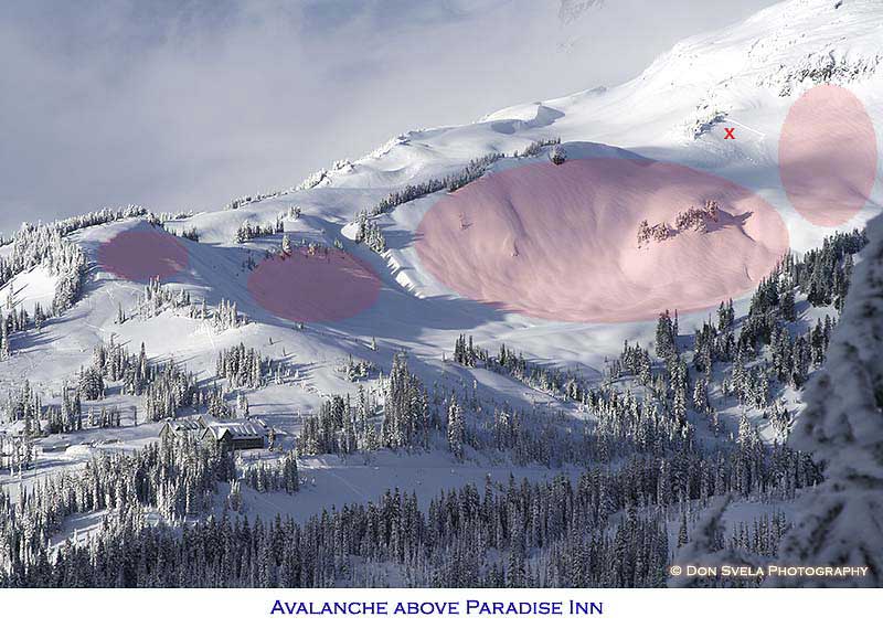
Thanks for all the comments. Here is another photo marking some of the areas - but not all - that could have slid had a skier or snowshoer ventured out there at the time.
author=bc_skier link=topic=8735.msg35132#msg35132 date=1199945094]
Here is another photo marking some of the areas - but not all - that could have slid had a skier or snowshoer ventured out there at the time.
Yeah, absolutely. In fact I would just shade all the slopes in Edith Creek basin pink. In the earlier thread in which we talked about the Edith Creek basin fatality, I suggested staying out of there entirely when avalanche conditions are iffy. Pass Alta Vista (the prominent bump above and left of the Paradise Inn) on the west side and stay on the other side of the tree studded ridge bounding the pink zone.
author=bc_skier link=topic=8735.msg35132#msg35132 date=1199945094]
Thanks for all the comments. Here is another photo marking some of the areas - but not all - that could have slid had a skier or snowshoer ventured out there at the time.
cross-loaded? east through north aspects?
Anyone mind breaking it down for a BC learner (less than newbie)? Why would the pink areas be more dangerous than the non-pink areas?
It seems like anything not on a ridgeline is sketchy.
Pete,
The pink areas are not meant to represent the only hazardous areas. As I wrote they are some - not all - avy hazard areas in the photo.
Cross loading is correct, which most likely built up a slab on any lee slope from northeast through southeast.
The pink areas are not meant to represent the only hazardous areas. As I wrote they are some - not all - avy hazard areas in the photo.
Cross loading is correct, which most likely built up a slab on any lee slope from northeast through southeast.
author=PetefromBoston link=topic=8735.msg35137#msg35137 date=1199975829">
cross-loaded? east through north aspects?
Anyone mind breaking it down for a BC learner (less than newbie)? Why would the pink areas be more dangerous than the non-pink areas?
It seems like anything not on a ridgeline is sketchy.
The photo was taken looking almost directly north. As you scan the pink areas from left to right, you're looking at slope aspects varying from east through south. I think most of the comments here have assumed that the recent prevailing wind would have been from the west (possibly SW through NW). So any slope not facing directly into that wind could have been loaded.
You're observation about "anything not on a ridgeline" is a good one. The winds don't always blow from west to east, so you have to be careful in your assumptions. The 1977 avalanche on the SW slope of Panorama Point (mentioned here) occurred after a period of high pressure, when easterly winds loaded the west side of Panorama.
Lowell,
Thanks for you explaination and additional info about the 1977 avalanche where the winds loaded the west slopes. Noting the direction of the prevailing winds is important but winds can change and come from many different directions on a big mountian like Rainier.
Cheers!
Thanks for you explaination and additional info about the 1977 avalanche where the winds loaded the west slopes. Noting the direction of the prevailing winds is important but winds can change and come from many different directions on a big mountian like Rainier.
Cheers!
author=vogtski link=topic=8735.msg35110#msg35110 date=1199923486]
The Dec 18 fatality was in the shaded gully 1/3 mile left in the larger view...
I'm still not clear on where the slide occurred. Could someone mark it on one of the above photos.
Thanks, Russ
There are photos under last month's Random Tracks thread "Slides at Paradise"
MY two cents on the slope that slid marked by the red X. I believe that slope was not only cross loaded but also top loaded.possibly both at the same time. Hence double loaded. This slope sitting on the north of Edith Saddle(my name) is affected by prevailing localized winds backing and veering. Directly above it is a small cliff band and some trees both capable of the Kerplop trigger. Kudos to those who brought out the fact that east winds bearing on this shoulder makes its west side and pan point dangerous.
One other example of this type of feature comes to mind is the ridgeline to climbers left going up to skyline lake at stevens.
One other example of this type of feature comes to mind is the ridgeline to climbers left going up to skyline lake at stevens.
Thanks guys for the info - I'm just trying to absorb as much knowledge as possible.
When making a decision, what would you say you put the most faith in - digging a pit, knowing the weather info, visual cues, aspect, or something else?
When making a decision, what would you say you put the most faith in - digging a pit, knowing the weather info, visual cues, aspect, or something else?
Pete,
Glad you have been taking in the discusion and absorbing all you can. However, if I were you I would enrole in a 3-day level one avalanche course as soon as possible. Personally I think it takes much to long to learn and "get" all that is needed to know to venture out in the backcountry by reading or skiing with friends. I am sure all of us would love to discuss or read everything that is needed to know to stay safe out in the backcountry, but there is just to much to know, it takes a good instructor to put it all together.
Perhaps others can chime in on their thoughts about this as well.
By the way, I put digging a pit last on my list of things when evaluating hazard. All of the other things you mentioned would come before the pit plus much much more. There is never one thing that is a sure fire way to determine hazard. Also, when I travel near or have the option of travelng in avalanche terrain, terrain selection is the biggest ace-up-my-sleeve. After all, if you stick to safe terrain, even on a high hazard day...you will be safe.
Good luck
author=PetefromBoston link=topic=8735.msg35176#msg35176 date=1200052858]I would say all of the above, plus trusting your "gut" feelings, having the training, and taking your brain with you ;-).
Thanks guys for the info - I'm just trying to absorb as much knowledge as possible.
When making a decision, what would you say you put the most faith in - digging a pit, knowing the weather info, visual cues, aspect, or something else?
In the "something other" category -- pole probes, Once you have an idea of the layers, you need to be able to see how they vary over distance and changes in aspect and elevation. You can dig multiple pits, but constantly probing with your poles can give you a lot of infomation on the depth of the wind deposit, strength of the underlying crust, density below the crust, and anyof the other factors you found in your pit tests or have gathered from following the snowpack and weather information.
Thanks to everyone for their comments and theories.
I am sure this could be analyzed and many theories could be possible, here are my thoughts in simple, non scientific terms.
The (X) slope slid because the wind loading finally built up enough slab (weight) on the slope to collapse the underlying weak layer.
Why did the other slopes not slide? In my opinion, they could have, had a skier or snowshoer ventured out in those areas at the time. The other slopes in that area were like a loaded gun ready to fire. The week layer was present in most of the snowpack; the weight of the slab on the leeward sides had not quite built up enough weight to trigger them naturally.
We have had an above average snowfall this past month and have had an incredibly touchy snowpack for the Northwest. One thing to take note about the avalanche incidences here in the Northwest this winter is the lack of backcountry skiers involved, which is to credit the level of awareness of backcountry skiers, the NWAC and the level of avalanche education available to us today.
To a deep winter,
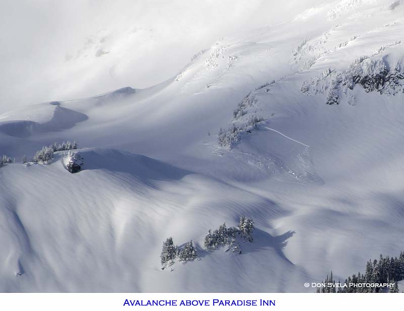
The picture of this slide has really been bothering me because the slope looks so benign. After searching through all of my pics, none of which really shows it well, I finally realized the one missing piece in this whole discussion, and that's slope angle. There is significant "foreshortening" in that photo that takes away the steepness of that slope. Now I agree with all that has been said here and that any slope can slide, but that is a very steep slope and in the summer has a significant cliff-band to the right of the trees and sometimes in winter a bit of a lip with convex rolling, probably right where the sharp line of the crown is seen. If I'm right, I hope that would keep most off of it in high ave danger days, assuming you could see it 8). Fog always adds another layer of risk!
I took this photo last Sunday 1/13. There's a significant pillow formed near that slide.

Reply to this TR
Please login first: