- Posts: 635
- Thank you received: 0
New storm cycle with 4-8 ft snow Feb26-Mar10,2014!
- Amar Andalkar
-
 Topic Author
- User
-

Less
More
12 years 1 month ago - 12 years 1 month ago #220942
by Amar Andalkar
New storm cycle with 4-8 ft snow Feb26-Mar10,2014! was created by Amar Andalkar
[size=small]Note: Original thread title: New storm cycle with 4-8 ft snow Feb26-Mar8,2014!
Title updated on 03/09/14 to reflect continuation of this storm cycle: New storm cycle with 4-8 ft snow Feb26-Mar10,2014![/size]
[hr]
Next major storm cycle is underway, will bring another 4-8 ft of snow over the first week of March to Washington, Oregon, and northern California!
See also earlier threads:
First major storm cycle of the 2013-14 season brings 4-8 ft of snow (January 7-14, 2014)
Another major storm cycle brings 2-5 ft of snow (January 28-February 1, 2014)
HUGE storm cycle brings 4-14 ft of snow (February 6-25, 2014)
Wasn't really planning to start another thread about the current storm cycle, given that the last one continued on much longer than expected and took up way too much time and effort to write about (although my reasons for continuing to post updates and calculate total snowfall amounts were still the right ones: primarily for my own curiosity and intellectual interest). And after the last huge storm cycle, this season's snowpack is pretty much all set with near-normal snowdepths from southwestern BC through Washington and into northern Oregon, so there's just not as much interest in another storm cycle now that the winter of despair has unexpectedly and belatedly morphed into something resembling a "normal" winter. The earlier storm cycles were so interesting primarily because the 2013-14 season had begun so poorly, with near-record low snowpack throughout the West Coast into early January due to an extraordinarily persistent ridge of high pressure off the coast during the fall and early winter, and it seemed uncertain if it would ever snow significantly this season.
Plus the models had been all over the place regarding this new storm cycle (other than the first 3 days from February 26 to March 1 which would primarily hit California), with lots of variation run-to-run and little consistency in predicted snowfall for the Pacific Northwest, other than a vague trend of very wet and eventually very warm this week. But the model predictions have come more into line over the last couple of days, and it looks like this storm cycle will be very big in the Pacific Northwest, perhaps even bordering on huge once again with snowfall totals possibly exceeding 8-10 ft over the next week at some sites, especially at high elevations. So this storm cycle now looks a lot more interesting, and maybe it will be worth writing about this one too. And it's a very rainy afternoon, good writing weather right now.
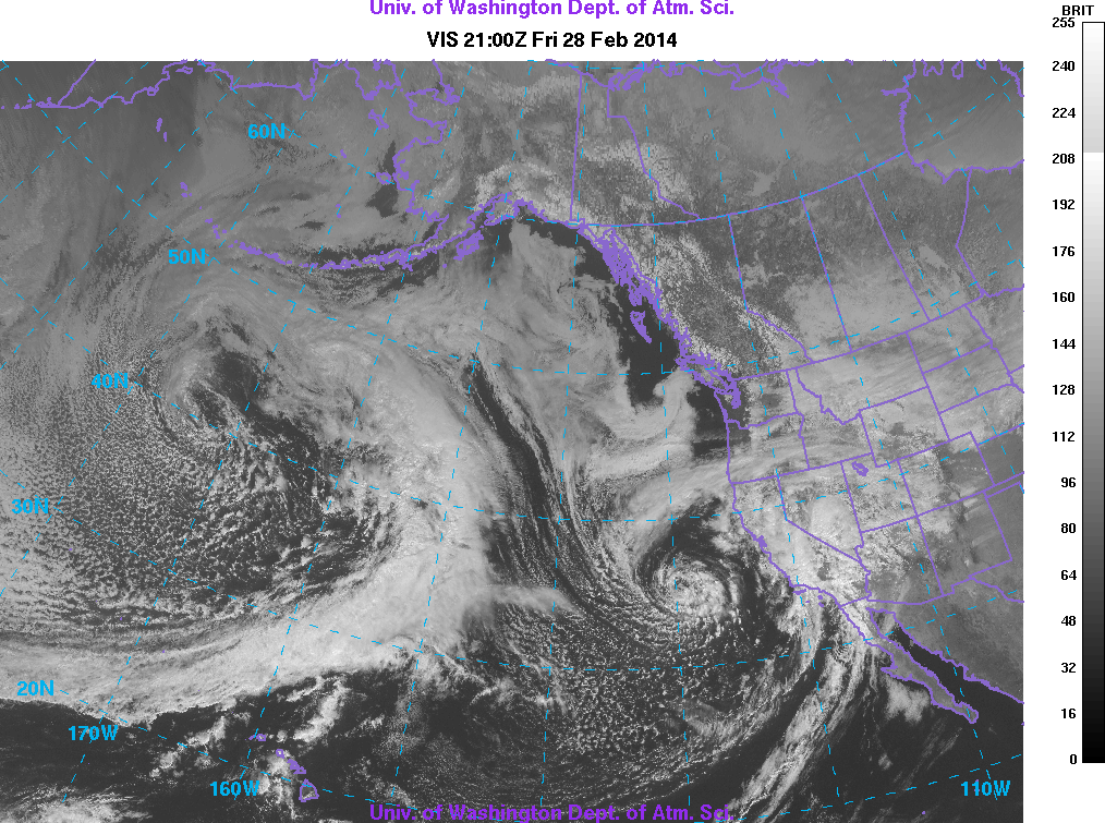
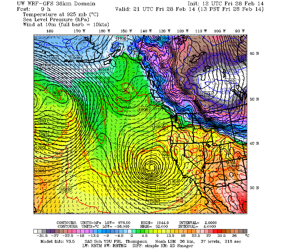
This storm cycle actually began several days ago in the middle of last week, just a day or so after the last remnants of the previous storm cycle faded out. A new strong jet stream developed over the north-central Pacific, aimed eastward towards California and generating a pair of storm systems. The first came ashore on Wednesday February 26, bringing up to 1-2 ft of snowfall by Thursday morning from Mount Shasta south to the southern Sierra Nevada, and was followed quickly by a second much stronger system from Thursday night through Saturday, which brought another 1-4 ft of snowfall to the same region, with highest amounts at the southern end. The second system also brought 5-10" of rainfall to parts of the Transverse Ranges of southern California just north of LA producing severe flash flooding and numerous mudslides, with eventually 1-2 ft of snowfall at the SoCal ski areas as temps cooled by Saturday. The second system's strong deep low was amazing to see both in satellite images (there's practically an eye visible) and even in the modeled chart of sea level pressure (both images at 1pm Friday):
Total snowfall amounts for the two systems ranged from about 2-3 ft on Mount Shasta and Lassen Peak above 6000 ft, and through much of the Sierra Nevada above 7000 ft (some rain mixed in below that), with over 4.5 ft at Mammoth Mountain and even over 4 ft at June Mountain. June is located east of the Sierra crest just north of Mammoth and was extremely rain-shadowed during the previous huge storm cycle, with only 7" of snowfall while Mammoth got 32" and some Sierra sites got 6-7 ft, but the intense cyclonic circulation of these systems produced strong southerly and southeasterly flow which could wrap precip around to locations on the east side of the range.
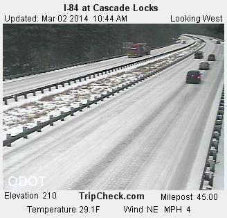
The next system in the storm cycle moved ashore much farther north on Saturday March 1, primarily into Washington and Oregon but with a tail of lighter precip extending south into California through much of the Sierra. New snowfall amounts as of Sunday morning were around 3-12" for most of the Washington and northern Oregon Cascades. Lowland snowfall also occurred in two limited areas which received strong Arctic outflow from a very cold air mass over the interior to the northeast, in parts of northwest Washington and southwestern BC due to Fraser River outflow and also along the Columbia River Gorge, but the extent and amounts of lowland snowfall were far less than models had originally predicted several days ago (the predicted lowland snowfall had diminished in each subsequent model run).
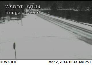
 [img]http://www.skimountaineer.com/TR/Images2014/Hood River Exit 64a_pid1863-2014Mar02-1047.jpg[/img]
Outside those areas exposed to the cold Arctic air mass and outflow, free air freezing levels on Sunday have generally ranged from 4000 ft in the northern Washington Cascades to 7000 ft in southern Oregon and northern California. Heavy snow and rain continued throughout the day Sunday, with new snowfall amounts of 6-14" during the day at many sites in Washington and northern Oregon, and a few inches extending south to the northern Sierra. Another system is expected to arrive early Monday, again primarily into Washington.
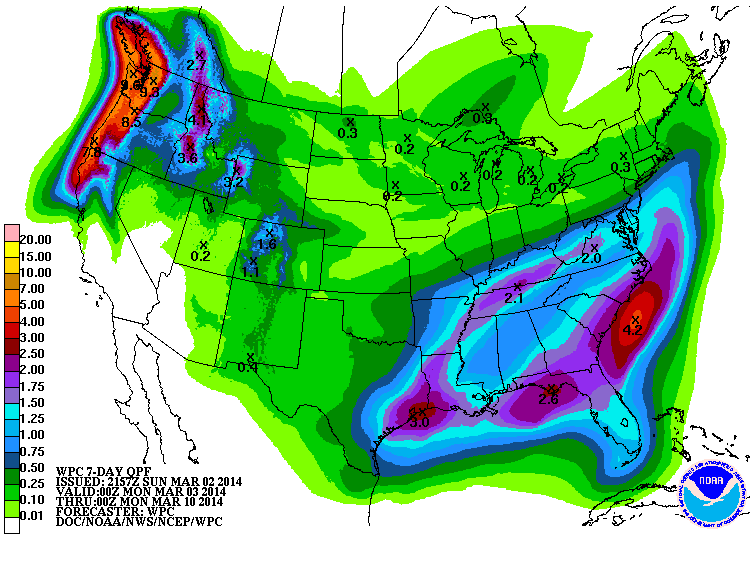
The NWS's GFS model and their Quantitative Precipitation Forecasts are showing up to 7-9" of precip over the next week for the mountains of southwestern BC, Washington, Oregon, and northern California, with less than 1" extending south into the Sierra Nevada. Here is total precipitation in inches predicted over the next 7 days through the afternoon of Sunday March 9:
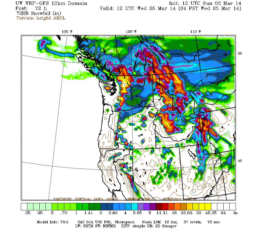
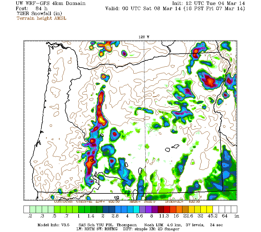
The high-resolution UW WRF-GFS model is showing total snowfall amounts up to 4-8 ft or more over the next week for the mountains of Washington, Oregon, and northern California. Snowfall during the next 3 days from this morning through 4am Wednesday is predicted to be 3-6 ft over the Olympics, Washington Cascades, and volcanic peaks of the Oregon Cascades and California Cascades, with perhaps 1-2 ft extending into the northern Sierra Nevada:
Higher resolution version of that, showing the Pacific Northwest and also zoomed in on Washington and Oregon:
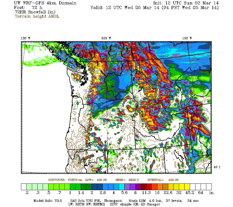
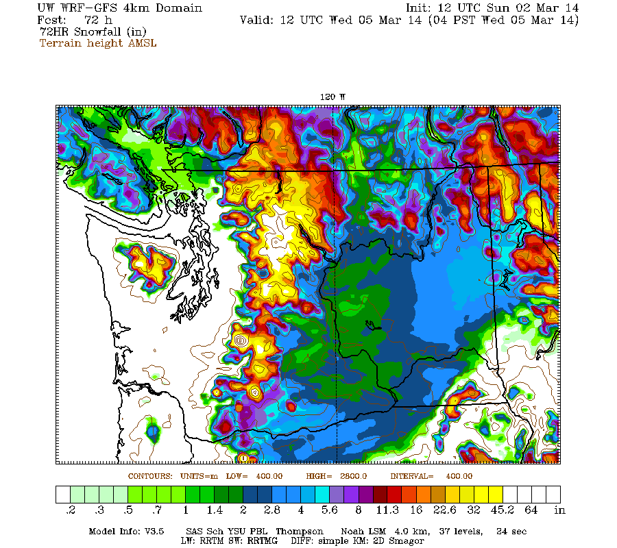
Maximum amounts of 4-6 ft (marked by white inside yellow) are shown over the west slopes of the Olympics, much of the north-central Washington Cascades, and the major volcanic peaks from Mount Rainier south to the Three Sisters region.
This loop shows how the model predictions for snowfall during the 3-day period through 4am Wednesday have evolved between 10 subsequent runs over the last 5 days, the D(model)/D(t). Lots of variation several days ago with radical changes run-to-run, but eventually settling into a more consistent picture the past couple of days:
www.atmos.washington.edu/~ovens/wxloop.c...2+v2014030512///+-st
Additional storm systems are predicted to arrive every 1-2 days through the end of next week, with perhaps the strongest system on Wednesday-Thursday. Additional snowfall during the subsequent 3 days ending 4am next Saturday is predicted to be another 2-4 ft over the Washington Cascades and southwestern BC, with 1-2 ft in the Oregon Cascades:
The D(model)/D(t) for that 3-day period has been fairly consistent thus far, although there have been only 4 model runs so far extending out to that period:
www.atmos.washington.edu/~ovens/wxloop.c...2+v2014030812///+-st
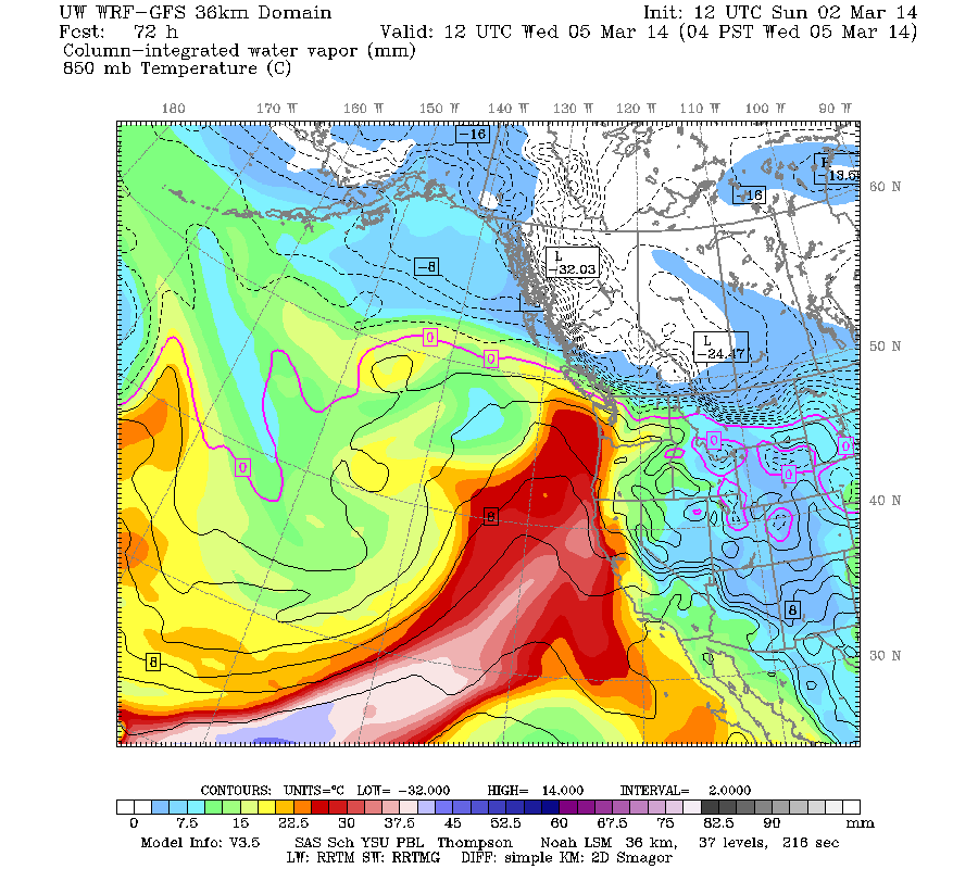
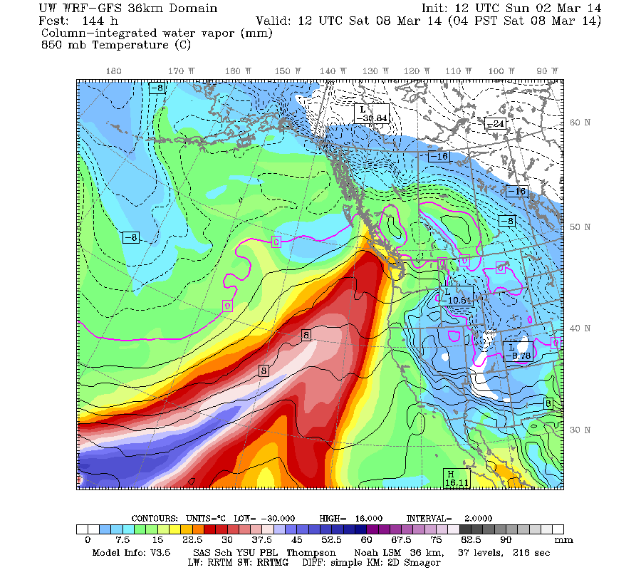
It looks like there will be two separate atmospheric river events during this week as part of this storm cycle, one arriving early Wednesday aimed at northern California and Oregon, and another arriving Friday aimed at Vancouver Island, eventually shifting southward towards Washington by Saturday and into Sunday:
So things will definitely be very wet if these predictions verify, and freezing levels will spike fairly high both times, but it also looks like there will be periods of more moderate freezing levels and very significant snowfall at most mountain locations before and after each big "Pineapple Express". Overall, this week appears to be very typical wintertime weather over the Pacific Northwest, which should be quite welcome given how atypical the weather has been for much of the 2013-14 season.
Title updated on 03/09/14 to reflect continuation of this storm cycle: New storm cycle with 4-8 ft snow Feb26-Mar10,2014![/size]
[hr]
Next major storm cycle is underway, will bring another 4-8 ft of snow over the first week of March to Washington, Oregon, and northern California!
See also earlier threads:
First major storm cycle of the 2013-14 season brings 4-8 ft of snow (January 7-14, 2014)
Another major storm cycle brings 2-5 ft of snow (January 28-February 1, 2014)
HUGE storm cycle brings 4-14 ft of snow (February 6-25, 2014)
Wasn't really planning to start another thread about the current storm cycle, given that the last one continued on much longer than expected and took up way too much time and effort to write about (although my reasons for continuing to post updates and calculate total snowfall amounts were still the right ones: primarily for my own curiosity and intellectual interest). And after the last huge storm cycle, this season's snowpack is pretty much all set with near-normal snowdepths from southwestern BC through Washington and into northern Oregon, so there's just not as much interest in another storm cycle now that the winter of despair has unexpectedly and belatedly morphed into something resembling a "normal" winter. The earlier storm cycles were so interesting primarily because the 2013-14 season had begun so poorly, with near-record low snowpack throughout the West Coast into early January due to an extraordinarily persistent ridge of high pressure off the coast during the fall and early winter, and it seemed uncertain if it would ever snow significantly this season.
Plus the models had been all over the place regarding this new storm cycle (other than the first 3 days from February 26 to March 1 which would primarily hit California), with lots of variation run-to-run and little consistency in predicted snowfall for the Pacific Northwest, other than a vague trend of very wet and eventually very warm this week. But the model predictions have come more into line over the last couple of days, and it looks like this storm cycle will be very big in the Pacific Northwest, perhaps even bordering on huge once again with snowfall totals possibly exceeding 8-10 ft over the next week at some sites, especially at high elevations. So this storm cycle now looks a lot more interesting, and maybe it will be worth writing about this one too. And it's a very rainy afternoon, good writing weather right now.
This storm cycle actually began several days ago in the middle of last week, just a day or so after the last remnants of the previous storm cycle faded out. A new strong jet stream developed over the north-central Pacific, aimed eastward towards California and generating a pair of storm systems. The first came ashore on Wednesday February 26, bringing up to 1-2 ft of snowfall by Thursday morning from Mount Shasta south to the southern Sierra Nevada, and was followed quickly by a second much stronger system from Thursday night through Saturday, which brought another 1-4 ft of snowfall to the same region, with highest amounts at the southern end. The second system also brought 5-10" of rainfall to parts of the Transverse Ranges of southern California just north of LA producing severe flash flooding and numerous mudslides, with eventually 1-2 ft of snowfall at the SoCal ski areas as temps cooled by Saturday. The second system's strong deep low was amazing to see both in satellite images (there's practically an eye visible) and even in the modeled chart of sea level pressure (both images at 1pm Friday):
Total snowfall amounts for the two systems ranged from about 2-3 ft on Mount Shasta and Lassen Peak above 6000 ft, and through much of the Sierra Nevada above 7000 ft (some rain mixed in below that), with over 4.5 ft at Mammoth Mountain and even over 4 ft at June Mountain. June is located east of the Sierra crest just north of Mammoth and was extremely rain-shadowed during the previous huge storm cycle, with only 7" of snowfall while Mammoth got 32" and some Sierra sites got 6-7 ft, but the intense cyclonic circulation of these systems produced strong southerly and southeasterly flow which could wrap precip around to locations on the east side of the range.
The next system in the storm cycle moved ashore much farther north on Saturday March 1, primarily into Washington and Oregon but with a tail of lighter precip extending south into California through much of the Sierra. New snowfall amounts as of Sunday morning were around 3-12" for most of the Washington and northern Oregon Cascades. Lowland snowfall also occurred in two limited areas which received strong Arctic outflow from a very cold air mass over the interior to the northeast, in parts of northwest Washington and southwestern BC due to Fraser River outflow and also along the Columbia River Gorge, but the extent and amounts of lowland snowfall were far less than models had originally predicted several days ago (the predicted lowland snowfall had diminished in each subsequent model run).
Outside those areas exposed to the cold Arctic air mass and outflow, free air freezing levels on Sunday have generally ranged from 4000 ft in the northern Washington Cascades to 7000 ft in southern Oregon and northern California. Heavy snow and rain continued throughout the day Sunday, with new snowfall amounts of 6-14" during the day at many sites in Washington and northern Oregon, and a few inches extending south to the northern Sierra. Another system is expected to arrive early Monday, again primarily into Washington.
The NWS's GFS model and their Quantitative Precipitation Forecasts are showing up to 7-9" of precip over the next week for the mountains of southwestern BC, Washington, Oregon, and northern California, with less than 1" extending south into the Sierra Nevada. Here is total precipitation in inches predicted over the next 7 days through the afternoon of Sunday March 9:
The high-resolution UW WRF-GFS model is showing total snowfall amounts up to 4-8 ft or more over the next week for the mountains of Washington, Oregon, and northern California. Snowfall during the next 3 days from this morning through 4am Wednesday is predicted to be 3-6 ft over the Olympics, Washington Cascades, and volcanic peaks of the Oregon Cascades and California Cascades, with perhaps 1-2 ft extending into the northern Sierra Nevada:
Higher resolution version of that, showing the Pacific Northwest and also zoomed in on Washington and Oregon:
Maximum amounts of 4-6 ft (marked by white inside yellow) are shown over the west slopes of the Olympics, much of the north-central Washington Cascades, and the major volcanic peaks from Mount Rainier south to the Three Sisters region.
This loop shows how the model predictions for snowfall during the 3-day period through 4am Wednesday have evolved between 10 subsequent runs over the last 5 days, the D(model)/D(t). Lots of variation several days ago with radical changes run-to-run, but eventually settling into a more consistent picture the past couple of days:
www.atmos.washington.edu/~ovens/wxloop.c...2+v2014030512///+-st
Additional storm systems are predicted to arrive every 1-2 days through the end of next week, with perhaps the strongest system on Wednesday-Thursday. Additional snowfall during the subsequent 3 days ending 4am next Saturday is predicted to be another 2-4 ft over the Washington Cascades and southwestern BC, with 1-2 ft in the Oregon Cascades:
The D(model)/D(t) for that 3-day period has been fairly consistent thus far, although there have been only 4 model runs so far extending out to that period:
www.atmos.washington.edu/~ovens/wxloop.c...2+v2014030812///+-st
It looks like there will be two separate atmospheric river events during this week as part of this storm cycle, one arriving early Wednesday aimed at northern California and Oregon, and another arriving Friday aimed at Vancouver Island, eventually shifting southward towards Washington by Saturday and into Sunday:
So things will definitely be very wet if these predictions verify, and freezing levels will spike fairly high both times, but it also looks like there will be periods of more moderate freezing levels and very significant snowfall at most mountain locations before and after each big "Pineapple Express". Overall, this week appears to be very typical wintertime weather over the Pacific Northwest, which should be quite welcome given how atypical the weather has been for much of the 2013-14 season.
Please Log in or Create an account to join the conversation.
- elliotts
-
- User
-
Less
More
- Posts: 6
- Thank you received: 0
12 years 1 month ago #220944
by elliotts
Replied by elliotts on topic Re: New storm cycle with 4-8 ft snow Feb26-Mar8,2014!
Thanks for starting another thread, Amar! I have enjoyed reading these this season.
Please Log in or Create an account to join the conversation.
- Zap
-
- User
-
Less
More
- Posts: 1212
- Thank you received: 3
12 years 1 month ago #220954
by Zap
Replied by Zap on topic Re: New storm cycle with 4-8 ft snow Feb26-Mar8,2014!
We decided to come back home from CO, UT and Tahoe from the reports. ")
Please Log in or Create an account to join the conversation.
- Amar Andalkar
-
Topic Author
- User
-
Less
More
- Posts: 635
- Thank you received: 0
12 years 1 month ago - 12 years 1 month ago #221026
by Amar Andalkar
Replied by Amar Andalkar on topic Re: New storm cycle with 4-8 ft snow Feb26-Mar8,2014!
Update #1: 48 hours after initial post, 2-5 ft of snow has already fallen from southwestern BC to California,
with an additional 4-8 ft (or more) predicted over the next week for southwestern BC, Washington, and Oregon!
Decided to skip posting an update yesterday, to avoid burnout and also give the upcoming storm systems more time to develop and have that reflected in the model predictions. There just wasn't that much new to update yesterday, other than several feet of new snowfall in the Washington Cascades! And that has been continuing!
Model predictions for snowfall over the past 3 days have generally verified quite well. About 2-5 ft of snowfall has occurred over the Washington and BC Cascades during the 3+ days since snowfall began on the morning of Saturday March 1, with about 1-2 ft farther north in southwestern BC and also throughout the Oregon and California Cascades, with about 1 ft extending through the northern Sierra Nevada and a few inches as far south as Mammoth Mountain. Quite an excellent match to the predictions in the previous post! Maximum snowfall amounts over that period include 56" at Mount Baker Ski Area, 39" at Stevens Pass, 31" at Holden Village, 25" at Alpental base with 35" at the top, and 29" at Mount Rainier Paradise. Amazingly, the 31" at Holden Village is greater than their average snowfall for the entire month of March (27"), and comes right on the heels of their record-setting February (more info about that in this post ). Maximum precip amounts since Saturday morning have generally been in the 4-6" range from Mount Baker south to Mount Hood.
Free air freezing levels since Sunday have generally averaged from 4000 ft in the northern Washington Cascades to 7000 ft in southern Oregon and northern California (snow levels about 1000 ft lower), but areas exposed to the cold Arctic air mass east of the Cascades and to easterly outflow kept continued snowfall at far lower elevations into Monday afternoon, when pressure gradients eased and the strong southwesterly push of warm air overwhelmed the easterly flow. The large amounts of new snowfall at Snoqualmie atop a thick freezing-rain crust from the end of the last storm cycle, followed by a changeover to rain, produced very high avalanche hazard, causing a roughly 16-hour total shutdown of Interstate 90 on Monday March 3 from around midnight to 4pm, with large natural and explosive-triggered avalanches reportedly carrying trees and other debris onto the roadway.
Very interestingly, it wasn't just Snoqualmie and Stevens benefitting from the cold easterly flow this time. There was strong Arctic outflow through the Skagit River valley on Saturday and Sunday, producing heavy snowfall at elevations below 1000 ft with Ross Dam (1240 ft, MP 134 on SR 20) recording 17" of new snow, Diablo Dam (890 ft, MP 128 on SR 20) 20", and Newhalem (530 ft, MP 120 on SR 20) 14" through Monday morning before it all changed over to rain. The outflow was not sufficient to produce much snow at Concrete (200 ft, MP 88 on SR 20), which got only 0.5" of snow -- the Skagit valley is far wider and shallower at Concrete than at Newhalem, thus dispersing and dissipating the Arctic outflow by that point. All four sites got roughly the same precip of 3-4" as seen in the data here:
[tt]
ROSS DAM (457185) 1240 ft DIABLO DAM (452157) 890 ft
Observed Daily Data: Mar 2014 Observed Daily Data: Mar 2014
Day MaxT MinT AvgT Pcpn Snow Snwg Day MaxT MinT AvgT Pcpn Snow Snwg
1 47 29 38.0 T T 8 1 50 31 40.5 T T 3
2 31 25 28.0 0.21 4.0 10 2 32 26 29.0 0.56 7.0 10
3 33 26 29.5 1.61 13.0 22 3 32 27 29.5 1.76 13.0 23
4 35 32 33.5 1.18 0.0 16 4 35 32 33.5 1.42 0.0 14
Smry 36.5 28.0 32.2 3.00 17.0 14.0 Smry 37.2 29.0 33.1 3.74 20.0 12.5
NEWHALEM (455840) 530 ft CONCRETE PPL FISH STN (451679) 200 ft
Observed Daily Data: Mar 2014 Observed Daily Data: Mar 2014
Day MaxT MinT AvgT Pcpn Snow Snwg Day MaxT MinT AvgT Pcpn Snow Snwg
1 53 34 43.5 0.00 0.0 0 1 52 37 44.5 T M M
2 35 27 31.0 0.67 7.0 7 2 39 31 35.0 0.34 0.5 1
3 31 28 29.5 1.50 7.0 12 3 37 32 34.5 1.45 0.0 0
4 34 31 32.5 1.50 0.0 8 4 41 36 38.5 1.40 0.0 0
Smry 38.2 30.0 34.1 3.67 14.0 6.8 Smry 42.2 34.0 38.1 3.19 0.5 0.3
[/tt]
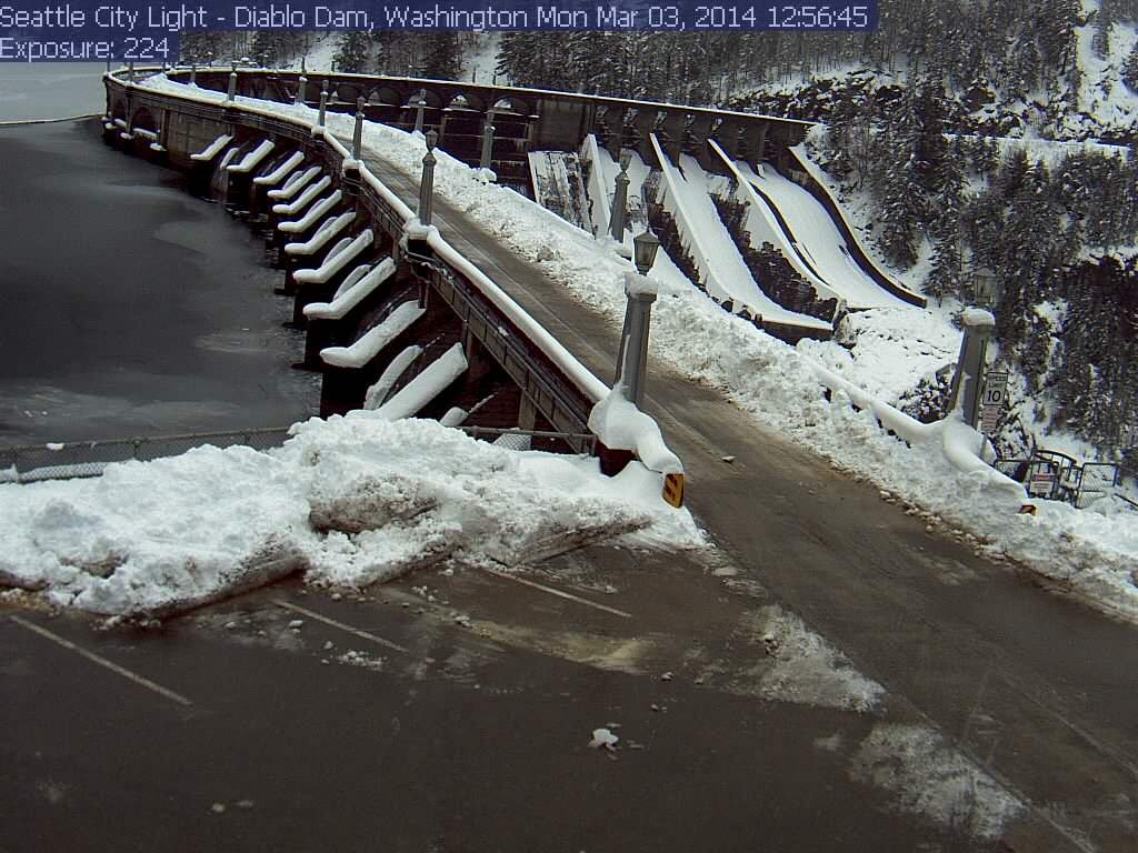
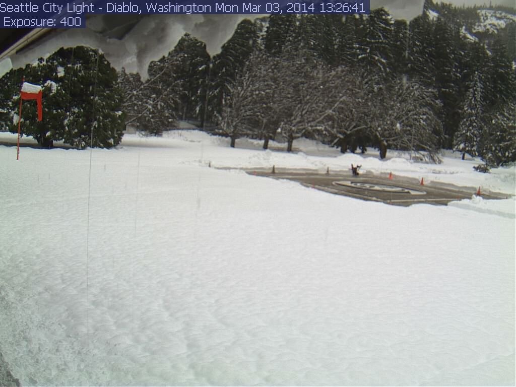
[size=small]Deep snow at Diablo on Monday, as seen on the Seattle City Light webcams . Top of Diablo Dam (1220 ft) at left, Diablo Helistop (890 ft) at right. [/size]
Two days after the initial post, 4 subsequent runs of the UW WRF-GFS model at 12-hour intervals continue to predict very large precip and snowfall amounts, although the highest snowfall amounts will still occur only at higher elevations due to strong southwesterly flow during the wettest parts of the upcoming systems. The predicted amounts for both precip and snowfall have actually increased significantly for Washington, and the storm cycle now appears likely to continue through at least next Tuesday.
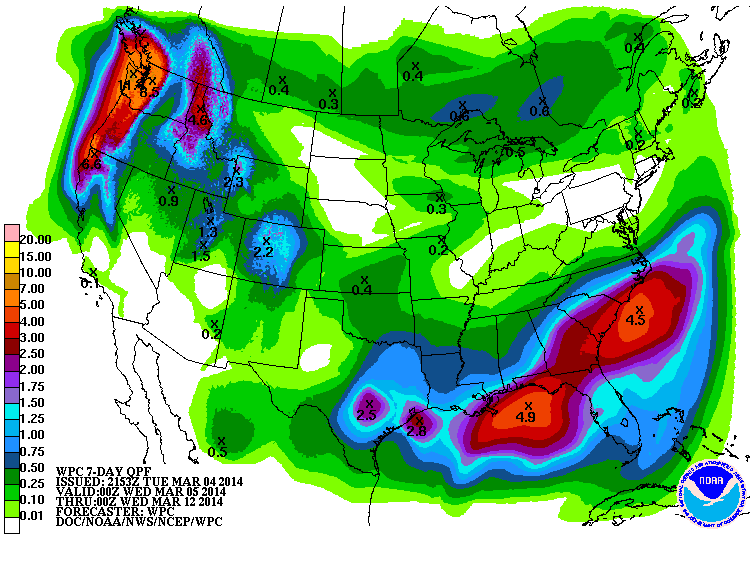
The NWS's GFS model and their Quantitative Precipitation Forecasts are showing up to 6-11" of additional precip over the next week for the mountains of southwestern BC, Washington, Oregon, and northern California, with about 1-2" extending south into the northern Sierra Nevada. Here is total precipitation in inches predicted over the next 7 days through the afternoon of Tuesday March 11:
The much-higher resolution and better handling of terrain in the UW model are predicting even greater precip amounts, with over 10" in spots during the next 3 days alone through 4pm Friday:
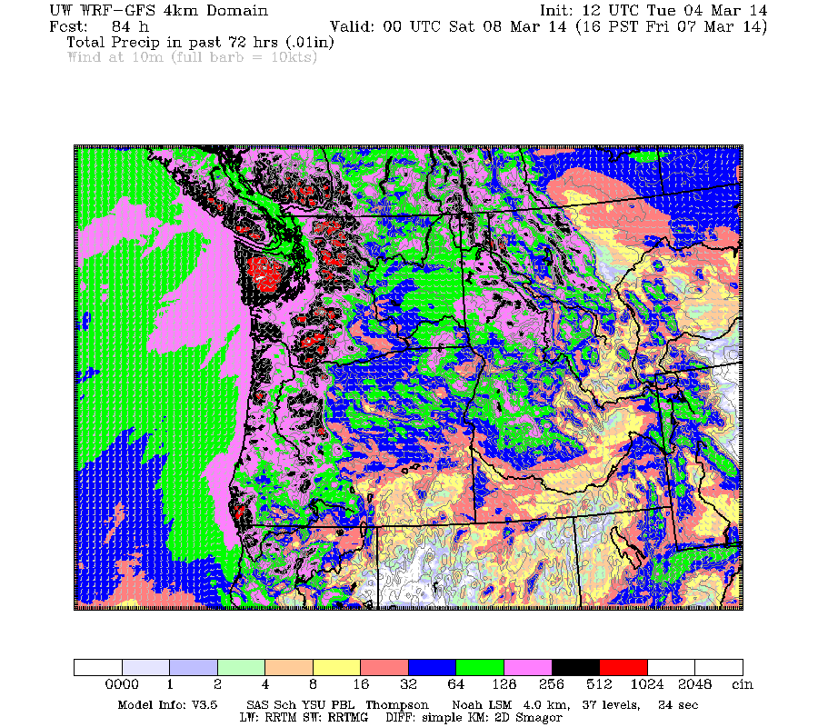
Maximum amounts of 10+" of precip (marked by white inside red) are shown over the west slopes of the Olympics, Mount Rainier, and Mount Saint Helens. Unfortunately the majority of that precip is going to fall as rain at most measurement sites, given that snow levels will rise to over 6000 ft in Washington and 7000 ft in Oregon during the day Wednesday and that night, but high elevation areas will get many feet of snow. By Thursday, the snow levels drop to around 4000-5000 ft, while heavy snowfall continues.
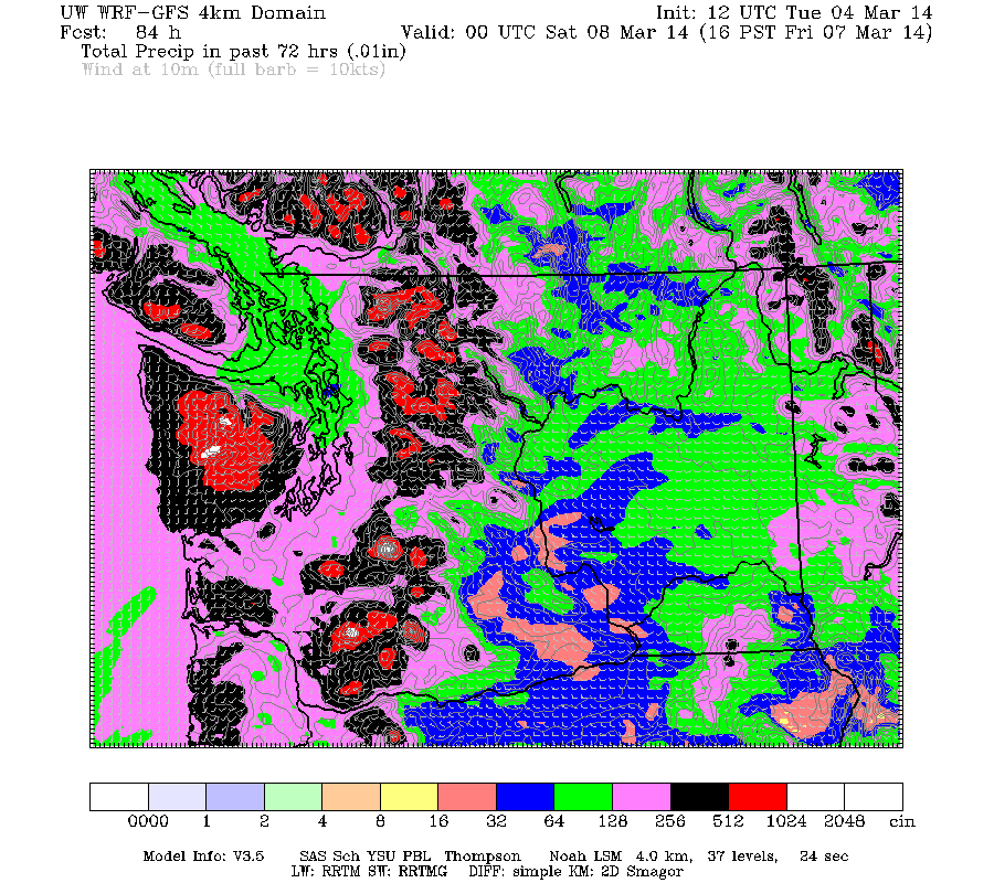
Snowfall during the next 3 days through 4pm Friday is predicted to be 2-7 ft over parts of southwestern BC, the Olympics, Washington Cascades, and volcanic peaks of the Oregon Cascades, with perhaps 1-3 ft extending as far south as Mount Shasta:
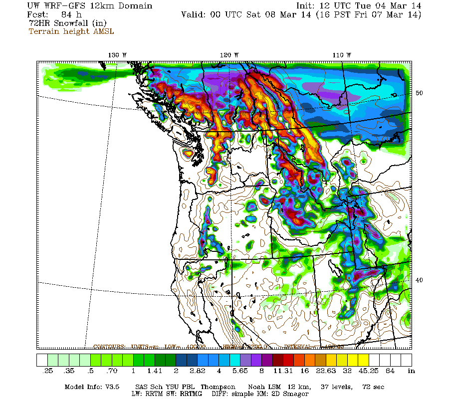
Higher resolution version of that, showing the Pacific Northwest and also zoomed in on Washington and Oregon:
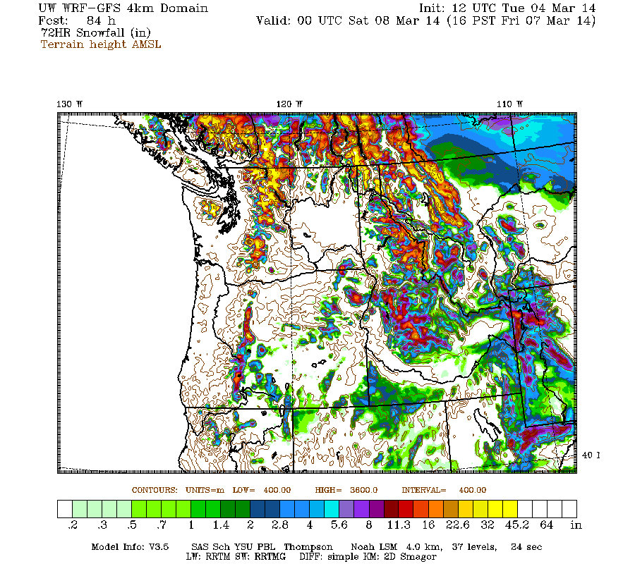
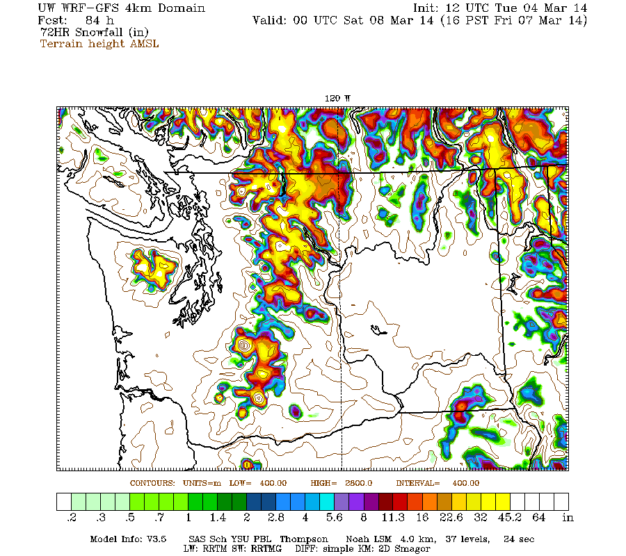
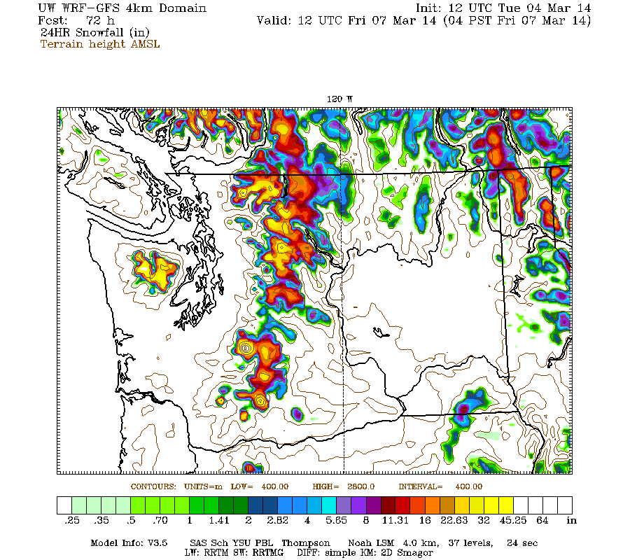
Maximum snowfall amounts of 4-7 ft (marked by white inside yellow) are shown along the west slopes and volcanic peaks of the Washington Cascades and Olympics, plus the Three Sisters region in Oregon. The most intense period of snowfall is Thursday through early Friday, when even the 24-hour totals are predicted to exceed 4 ft on Mounts Baker, Rainier, and parts of the west slopes of the Olympics above about 6000 ft:
It won't be easy to see if such an extreme snowfall prediction actually verifies this time, since there are no measurement sites at high enough elevation in these areas. However, real 24-hour snowfall amounts in the 2-3 ft range are likely at the highest measurement sites such as Paradise.
This loop shows how the model predictions for snowfall during the 3-day period through 4pm Friday have evolved between 10 subsequent runs over the last 5 days, the D(model)/D(t). Very consistent in the overall picture, with ongoing variation in amounts:
www.atmos.washington.edu/~ovens/wxloop.c...2+v2014030800///+-st
There is expected to be a major lull in precipitation from Friday evening through Saturday for Oregon and Washington, as a transient weak ridge pushes the next incoming system northward towards the central BC coast and Vancouver Island. Eventually that system and its associated atmospheric river shift southward over Washington and Oregon by late Saturday. That weekend system is currently predicted to have even higher snow levels than the one on Wednesday (perhaps 7000-8000 ft), but not quite as much precip either. In any case, snowfall over the weekend will once again be limited to higher elevations only.
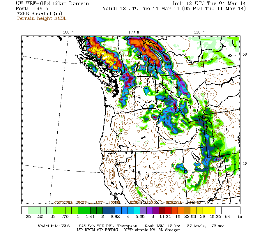
Another system on Monday into Tuesday may bring another shot of snowfall at more reasonable snow levels. Additional snowfall during the subsequent 3 days ending 5am (PDT already!) next Tuesday is predicted to be 2-4 ft over southwestern BC, with 1-2 ft in the Washington Cascades:
But that's a long way out, given that the evolution of the very strong system on Wednesday will have a significant effect on the development of the subsequent systems, and on upcoming model predictions.
with an additional 4-8 ft (or more) predicted over the next week for southwestern BC, Washington, and Oregon!
Decided to skip posting an update yesterday, to avoid burnout and also give the upcoming storm systems more time to develop and have that reflected in the model predictions. There just wasn't that much new to update yesterday, other than several feet of new snowfall in the Washington Cascades! And that has been continuing!
Model predictions for snowfall over the past 3 days have generally verified quite well. About 2-5 ft of snowfall has occurred over the Washington and BC Cascades during the 3+ days since snowfall began on the morning of Saturday March 1, with about 1-2 ft farther north in southwestern BC and also throughout the Oregon and California Cascades, with about 1 ft extending through the northern Sierra Nevada and a few inches as far south as Mammoth Mountain. Quite an excellent match to the predictions in the previous post! Maximum snowfall amounts over that period include 56" at Mount Baker Ski Area, 39" at Stevens Pass, 31" at Holden Village, 25" at Alpental base with 35" at the top, and 29" at Mount Rainier Paradise. Amazingly, the 31" at Holden Village is greater than their average snowfall for the entire month of March (27"), and comes right on the heels of their record-setting February (more info about that in this post ). Maximum precip amounts since Saturday morning have generally been in the 4-6" range from Mount Baker south to Mount Hood.
Free air freezing levels since Sunday have generally averaged from 4000 ft in the northern Washington Cascades to 7000 ft in southern Oregon and northern California (snow levels about 1000 ft lower), but areas exposed to the cold Arctic air mass east of the Cascades and to easterly outflow kept continued snowfall at far lower elevations into Monday afternoon, when pressure gradients eased and the strong southwesterly push of warm air overwhelmed the easterly flow. The large amounts of new snowfall at Snoqualmie atop a thick freezing-rain crust from the end of the last storm cycle, followed by a changeover to rain, produced very high avalanche hazard, causing a roughly 16-hour total shutdown of Interstate 90 on Monday March 3 from around midnight to 4pm, with large natural and explosive-triggered avalanches reportedly carrying trees and other debris onto the roadway.
Very interestingly, it wasn't just Snoqualmie and Stevens benefitting from the cold easterly flow this time. There was strong Arctic outflow through the Skagit River valley on Saturday and Sunday, producing heavy snowfall at elevations below 1000 ft with Ross Dam (1240 ft, MP 134 on SR 20) recording 17" of new snow, Diablo Dam (890 ft, MP 128 on SR 20) 20", and Newhalem (530 ft, MP 120 on SR 20) 14" through Monday morning before it all changed over to rain. The outflow was not sufficient to produce much snow at Concrete (200 ft, MP 88 on SR 20), which got only 0.5" of snow -- the Skagit valley is far wider and shallower at Concrete than at Newhalem, thus dispersing and dissipating the Arctic outflow by that point. All four sites got roughly the same precip of 3-4" as seen in the data here:
[tt]
ROSS DAM (457185) 1240 ft DIABLO DAM (452157) 890 ft
Observed Daily Data: Mar 2014 Observed Daily Data: Mar 2014
Day MaxT MinT AvgT Pcpn Snow Snwg Day MaxT MinT AvgT Pcpn Snow Snwg
1 47 29 38.0 T T 8 1 50 31 40.5 T T 3
2 31 25 28.0 0.21 4.0 10 2 32 26 29.0 0.56 7.0 10
3 33 26 29.5 1.61 13.0 22 3 32 27 29.5 1.76 13.0 23
4 35 32 33.5 1.18 0.0 16 4 35 32 33.5 1.42 0.0 14
Smry 36.5 28.0 32.2 3.00 17.0 14.0 Smry 37.2 29.0 33.1 3.74 20.0 12.5
NEWHALEM (455840) 530 ft CONCRETE PPL FISH STN (451679) 200 ft
Observed Daily Data: Mar 2014 Observed Daily Data: Mar 2014
Day MaxT MinT AvgT Pcpn Snow Snwg Day MaxT MinT AvgT Pcpn Snow Snwg
1 53 34 43.5 0.00 0.0 0 1 52 37 44.5 T M M
2 35 27 31.0 0.67 7.0 7 2 39 31 35.0 0.34 0.5 1
3 31 28 29.5 1.50 7.0 12 3 37 32 34.5 1.45 0.0 0
4 34 31 32.5 1.50 0.0 8 4 41 36 38.5 1.40 0.0 0
Smry 38.2 30.0 34.1 3.67 14.0 6.8 Smry 42.2 34.0 38.1 3.19 0.5 0.3
[/tt]
[size=small]Deep snow at Diablo on Monday, as seen on the Seattle City Light webcams . Top of Diablo Dam (1220 ft) at left, Diablo Helistop (890 ft) at right. [/size]
Two days after the initial post, 4 subsequent runs of the UW WRF-GFS model at 12-hour intervals continue to predict very large precip and snowfall amounts, although the highest snowfall amounts will still occur only at higher elevations due to strong southwesterly flow during the wettest parts of the upcoming systems. The predicted amounts for both precip and snowfall have actually increased significantly for Washington, and the storm cycle now appears likely to continue through at least next Tuesday.
The NWS's GFS model and their Quantitative Precipitation Forecasts are showing up to 6-11" of additional precip over the next week for the mountains of southwestern BC, Washington, Oregon, and northern California, with about 1-2" extending south into the northern Sierra Nevada. Here is total precipitation in inches predicted over the next 7 days through the afternoon of Tuesday March 11:
The much-higher resolution and better handling of terrain in the UW model are predicting even greater precip amounts, with over 10" in spots during the next 3 days alone through 4pm Friday:
Maximum amounts of 10+" of precip (marked by white inside red) are shown over the west slopes of the Olympics, Mount Rainier, and Mount Saint Helens. Unfortunately the majority of that precip is going to fall as rain at most measurement sites, given that snow levels will rise to over 6000 ft in Washington and 7000 ft in Oregon during the day Wednesday and that night, but high elevation areas will get many feet of snow. By Thursday, the snow levels drop to around 4000-5000 ft, while heavy snowfall continues.
Snowfall during the next 3 days through 4pm Friday is predicted to be 2-7 ft over parts of southwestern BC, the Olympics, Washington Cascades, and volcanic peaks of the Oregon Cascades, with perhaps 1-3 ft extending as far south as Mount Shasta:
Higher resolution version of that, showing the Pacific Northwest and also zoomed in on Washington and Oregon:
Maximum snowfall amounts of 4-7 ft (marked by white inside yellow) are shown along the west slopes and volcanic peaks of the Washington Cascades and Olympics, plus the Three Sisters region in Oregon. The most intense period of snowfall is Thursday through early Friday, when even the 24-hour totals are predicted to exceed 4 ft on Mounts Baker, Rainier, and parts of the west slopes of the Olympics above about 6000 ft:
It won't be easy to see if such an extreme snowfall prediction actually verifies this time, since there are no measurement sites at high enough elevation in these areas. However, real 24-hour snowfall amounts in the 2-3 ft range are likely at the highest measurement sites such as Paradise.
This loop shows how the model predictions for snowfall during the 3-day period through 4pm Friday have evolved between 10 subsequent runs over the last 5 days, the D(model)/D(t). Very consistent in the overall picture, with ongoing variation in amounts:
www.atmos.washington.edu/~ovens/wxloop.c...2+v2014030800///+-st
There is expected to be a major lull in precipitation from Friday evening through Saturday for Oregon and Washington, as a transient weak ridge pushes the next incoming system northward towards the central BC coast and Vancouver Island. Eventually that system and its associated atmospheric river shift southward over Washington and Oregon by late Saturday. That weekend system is currently predicted to have even higher snow levels than the one on Wednesday (perhaps 7000-8000 ft), but not quite as much precip either. In any case, snowfall over the weekend will once again be limited to higher elevations only.
Another system on Monday into Tuesday may bring another shot of snowfall at more reasonable snow levels. Additional snowfall during the subsequent 3 days ending 5am (PDT already!) next Tuesday is predicted to be 2-4 ft over southwestern BC, with 1-2 ft in the Washington Cascades:
But that's a long way out, given that the evolution of the very strong system on Wednesday will have a significant effect on the development of the subsequent systems, and on upcoming model predictions.
Please Log in or Create an account to join the conversation.
- DendriteSupertramp
-
- User
-
Less
More
- Posts: 25
- Thank you received: 0
12 years 1 month ago #221038
by DendriteSupertramp
Replied by DendriteSupertramp on topic Re: New storm cycle with 4-8 ft snow Feb26-Mar8,2014!
Pineapples are good......but not conducive to pow skiing.
I am looking at the potential for storms starting after 3/16.
MJO and PNA seem to take a dive into the good zones for Pacific NW storms starting around this time. Something to watch.
Any thoughts here?
I am looking at the potential for storms starting after 3/16.
MJO and PNA seem to take a dive into the good zones for Pacific NW storms starting around this time. Something to watch.
Any thoughts here?
Please Log in or Create an account to join the conversation.
- Amar Andalkar
-
Topic Author
- User
-
Less
More
- Posts: 635
- Thank you received: 0
12 years 1 month ago #221049
by Amar Andalkar
I usually don't pay too much attention to predictions more than 7 days out, especially during a period of very active weather like the current one when there is so much to follow and try to keep up with right now. It's usually a waste of mental effort, at least for me, although it seems more worthwhile during periods of inactive weather while hoping for the next big storm system. I did take a quick look right now at the NWS Climate Prediction Center's Madden–Julian oscillation and Pacific / North American teleconnection pattern forecasts, but it's hard to give much weight to those predictions when even those making them acknowledge their severe limitations and lack of forecast skill. Sure, it looks "good" that the PNA is predicted to turn negative after mid-March, but even if that does come true, it has very limited correlation with the actual occurrence of snowfall or powder at any particular location in the Northwest (it is somewhat correlated with an increase in its likelihood).
And it also seems that not much has changed over the last decade in terms of improving forecasts over the weekly to seasonal (30-90 days) time scales like those for MJO or PNA (or longer time scales like ENSO), especially compared to the radical improvements in the accuracy of short-term (0-7 days) weather models like the UW WRF-GFS. Without which all of these storm cycle threads would simply not be possible to write. If looking for info about what's going to happen after mid-March, I'd put more faith on the extended GFS model which runs out to 16 days (so to March 21 now) and is currently predicting a change to northwesterly flow over this region by Wednesday March 19, with significant precip. But really, the 8-16 day GFS forecasts have little skill, they are still no better than climatology (and climatology has near-zero predictive value for heavy snowfall or powder since those are not "normal" or average events). There is little hope for improvement in forecasts 2 weeks out because the atmosphere is chaotic, and appears to be not predictable (in detail such as storm systems and snowfall) that far out. Sorry it sounds so hopeless, but that's how it is.
Replied by Amar Andalkar on topic Re: New storm cycle with 4-8 ft snow Feb26-Mar8,2014!
Pineapples are good......but not conducive to pow skiing.
I am looking at the potential for storms starting after 3/16.
MJO and PNA seem to take a dive into the good zones for Pacific NW storms starting around this time. Something to watch.
Any thoughts here?
I usually don't pay too much attention to predictions more than 7 days out, especially during a period of very active weather like the current one when there is so much to follow and try to keep up with right now. It's usually a waste of mental effort, at least for me, although it seems more worthwhile during periods of inactive weather while hoping for the next big storm system. I did take a quick look right now at the NWS Climate Prediction Center's Madden–Julian oscillation and Pacific / North American teleconnection pattern forecasts, but it's hard to give much weight to those predictions when even those making them acknowledge their severe limitations and lack of forecast skill. Sure, it looks "good" that the PNA is predicted to turn negative after mid-March, but even if that does come true, it has very limited correlation with the actual occurrence of snowfall or powder at any particular location in the Northwest (it is somewhat correlated with an increase in its likelihood).
And it also seems that not much has changed over the last decade in terms of improving forecasts over the weekly to seasonal (30-90 days) time scales like those for MJO or PNA (or longer time scales like ENSO), especially compared to the radical improvements in the accuracy of short-term (0-7 days) weather models like the UW WRF-GFS. Without which all of these storm cycle threads would simply not be possible to write. If looking for info about what's going to happen after mid-March, I'd put more faith on the extended GFS model which runs out to 16 days (so to March 21 now) and is currently predicting a change to northwesterly flow over this region by Wednesday March 19, with significant precip. But really, the 8-16 day GFS forecasts have little skill, they are still no better than climatology (and climatology has near-zero predictive value for heavy snowfall or powder since those are not "normal" or average events). There is little hope for improvement in forecasts 2 weeks out because the atmosphere is chaotic, and appears to be not predictable (in detail such as storm systems and snowfall) that far out. Sorry it sounds so hopeless, but that's how it is.
Please Log in or Create an account to join the conversation.