- Posts: 464
- Thank you received: 0
Forest Serv. replaces bridge w/ pile of snowballs
- garyabrill
-
 Topic Author
- User
-

Less
More
15 years 5 days ago #199581
by garyabrill
Forest Serv. replaces bridge w/ pile of snowballs was created by garyabrill
What actually happened:
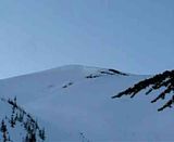
A large class 3.5 to 4 avalanche released naturally on a NW aspect on 4/6 between about 0300 and 0600 based on new snow amounts covering the debris. At 7000' the crown is about 150 yards wide, and for much of it's width about 12' high. It apparently released when a not that large chunk of a cornice fell onto a small section of the starting zone where the angle was in the range of 42-44 degrees. The rest of the starting zone angle was 35-38 degrees ranging down to the low 30's on it's right edge. The slab length was about 100 yards. The avalanche then encountered a lower angle section of slope where it left numerous large blocks, leaving the upper track looking like a wrecking yard for white Land Rovers, Navigators and with the occasional Hummer thrown in for good measure. The slide continued down until it reached a gully at roughly 5800'. At this point it stepped down into wet snow (a 2-3' crown was visible on the westerly side of a moraine) and entrained a large volume of snow. The avalanche deposition which consists of large rounded balls looks to be 20'-40' deep and continued down to 3600' (and beyond). Only about 6" of dry snow covers the debris. The bridge to Kulshan Cabin undoubtedly followed the debris downslope. The debris completely obliterated the line of the creek and in places extends into the forest a short distance.
Although only a fraction of the size of the 1990 slide, it is nonetheless impressive.
Another perhaps 5' deep slab about 100 yards wide released around the same time on a SW aspect near 7000' just west of Chowder Ridge. The avalanche debris doesn't appear to be heavily covered and a forested area has become a ski run in the run-out zone.
These slides (especially the first) indicate that the deep weakness is still susceptible to failure particularly when recently loaded (or when warm) with a sufficient trigger.
The Coleman Glacier, which is extremely well filled in, looks like it is trying to mimic the Muir Snowfield with very large wind ridges the length of the upper glacier.
Please Log in or Create an account to join the conversation.
- markharf
-
- User
-
Less
More
- Posts: 342
- Thank you received: 3
15 years 5 days ago #199587
by markharf
Replied by markharf on topic Re: Forest Serv. replaces bridge w/ pile of snowballs
Gary, I happen to know where these places are located.....but I bet a lot of people don't. Would you consider describing them a bit more completely? This might make your post more useful.
Mark
Mark
Please Log in or Create an account to join the conversation.
- garyabrill
-
Topic Author
- User
-
Less
More
- Posts: 464
- Thank you received: 0
15 years 5 days ago #199591
by garyabrill
Replied by garyabrill on topic Re: Forest Serv. replaces bridge w/ pile of snowballs
Sure, Mark.
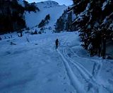
This is the bridge that one crosses 50 yards in from the trailhead on the route from the Glacier Creek Road to the north (Coleman Glacier) side of Mt. Baker. The lack of a bridge will not be an issue for a number of months because of the solid, deep avalanche debris.
The avalanche on Chowder Ridge is about 1/2 mile west of Hadley Peak which is adjacent to (just north of) Bastille Ridge and the Roosevelt Glacier on Mt. Baker.
Please Log in or Create an account to join the conversation.
- andyrew
-
- User
-
Less
More
- Posts: 116
- Thank you received: 0
15 years 5 days ago #199595
by andyrew
Replied by andyrew on topic Re: Forest Serv. replaces bridge w/ pile of snowballs
^^^
Aka, the footbridge over Grouse Creek, it sounds like.
Crazy conditions. I wonder what has shaken loose on Rainier.
Aka, the footbridge over Grouse Creek, it sounds like.
Crazy conditions. I wonder what has shaken loose on Rainier.
Please Log in or Create an account to join the conversation.
- ryanl
-
- User
-
Less
More
- Posts: 48
- Thank you received: 0
15 years 3 days ago #199660
by ryanl
Replied by ryanl on topic Re: Forest Serv. replaces bridge w/ pile of snowballs
Click the images. Wow.
Please Log in or Create an account to join the conversation.
- rlsg
-
- User
-
Less
More
- Posts: 226
- Thank you received: 0
15 years 2 days ago #199666
by rlsg
Replied by rlsg on topic Re: Forest Serv. replaces bridge w/ pile of snowballs
I appreciate learning the location too! Very informing report..thanks!!
Please Log in or Create an account to join the conversation.