- Posts: 464
- Thank you received: 0
Forest Serv. replaces bridge w/ pile of snowballs
- garyabrill
- [garyabrill]
-
 Topic Author
- Offline
- Senior Member
-

Less
More
08 Apr 2011 18:21 #199581
by garyabrill
Forest Serv. replaces bridge w/ pile of snowballs was created by garyabrill
What actually happened:
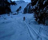
A large class 3.5 to 4 avalanche released naturally on a NW aspect on 4/6 between about 0300 and 0600 based on new snow amounts covering the debris. At 7000' the crown is about 150 yards wide, and for much of it's width about 12' high. It apparently released when a not that large chunk of a cornice fell onto a small section of the starting zone where the angle was in the range of 42-44 degrees. The rest of the starting zone angle was 35-38 degrees ranging down to the low 30's on it's right edge. The slab length was about 100 yards. The avalanche then encountered a lower angle section of slope where it left numerous large blocks, leaving the upper track looking like a wrecking yard for white Land Rovers, Navigators and with the occasional Hummer thrown in for good measure. The slide continued down until it reached a gully at roughly 5800'. At this point it stepped down into wet snow (a 2-3' crown was visible on the westerly side of a moraine) and entrained a large volume of snow. The avalanche deposition which consists of large rounded balls looks to be 20'-40' deep and continued down to 3600' (and beyond). Only about 6" of dry snow covers the debris. The bridge to Kulshan Cabin undoubtedly followed the debris downslope. The debris completely obliterated the line of the creek and in places extends into the forest a short distance.
Although only a fraction of the size of the 1990 slide, it is nonetheless impressive.
Another perhaps 5' deep slab about 100 yards wide released around the same time on a SW aspect near 7000' just west of Chowder Ridge. The avalanche debris doesn't appear to be heavily covered and a forested area has become a ski run in the run-out zone.
These slides (especially the first) indicate that the deep weakness is still susceptible to failure particularly when recently loaded (or when warm) with a sufficient trigger.
The Coleman Glacier, which is extremely well filled in, looks like it is trying to mimic the Muir Snowfield with very large wind ridges the length of the upper glacier.
Please Log in or Create an account to join the conversation.
- markharf
- [markharf]
-
- Offline
- Senior Member
-
Less
More
- Posts: 339
- Thank you received: 3
08 Apr 2011 19:19 #199587
by markharf
Replied by markharf on topic Re: Forest Serv. replaces bridge w/ pile of snowballs
Gary, I happen to know where these places are located.....but I bet a lot of people don't. Would you consider describing them a bit more completely? This might make your post more useful.
Mark
Mark
Please Log in or Create an account to join the conversation.
- garyabrill
- [garyabrill]
-
Topic Author
- Offline
- Senior Member
-
Less
More
- Posts: 464
- Thank you received: 0
08 Apr 2011 21:18 #199591
by garyabrill
Replied by garyabrill on topic Re: Forest Serv. replaces bridge w/ pile of snowballs
Sure, Mark.
This is the bridge that one crosses 50 yards in from the trailhead on the route from the Glacier Creek Road to the north (Coleman Glacier) side of Mt. Baker. The lack of a bridge will not be an issue for a number of months because of the solid, deep avalanche debris.
The avalanche on Chowder Ridge is about 1/2 mile west of Hadley Peak which is adjacent to (just north of) Bastille Ridge and the Roosevelt Glacier on Mt. Baker.
Please Log in or Create an account to join the conversation.
- andyrew
- [andyrew609]
-
- Offline
- Junior Member
-

Less
More
- Posts: 116
- Thank you received: 0
08 Apr 2011 21:51 #199595
by andyrew
Replied by andyrew on topic Re: Forest Serv. replaces bridge w/ pile of snowballs
^^^
Aka, the footbridge over Grouse Creek, it sounds like.
Crazy conditions. I wonder what has shaken loose on Rainier.
Aka, the footbridge over Grouse Creek, it sounds like.
Crazy conditions. I wonder what has shaken loose on Rainier.
Please Log in or Create an account to join the conversation.
- ryanl
- [ryanl]
-
- Offline
- New Member
-

Less
More
- Posts: 48
- Thank you received: 0
10 Apr 2011 21:32 #199660
by ryanl
Replied by ryanl on topic Re: Forest Serv. replaces bridge w/ pile of snowballs
Click the images. Wow.
Please Log in or Create an account to join the conversation.
- rlsg
- [rlsg]
-
- Offline
- Junior Member
-
Less
More
- Posts: 226
- Thank you received: 0
11 Apr 2011 12:26 #199666
by rlsg
Replied by rlsg on topic Re: Forest Serv. replaces bridge w/ pile of snowballs
I appreciate learning the location too! Very informing report..thanks!!
Please Log in or Create an account to join the conversation.
- Amar Andalkar
- [andalkar]
-
- Offline
- Premium Member
-

Less
More
- Posts: 635
- Thank you received: 0
11 Apr 2011 18:36 - 11 Apr 2011 18:39 #199675
by Amar Andalkar
Replied by Amar Andalkar on topic Re: Forest Serv. replaces bridge w/ pile of snowballs
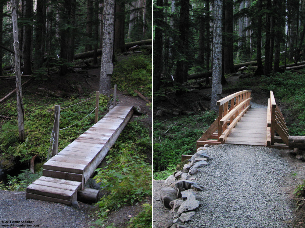
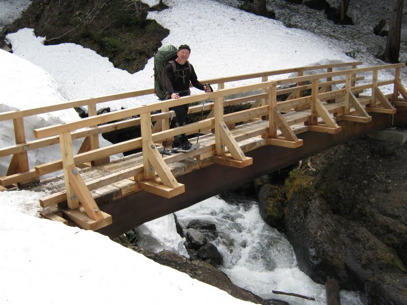
So the nice new steel and timber bridge built in June-July 2010 is gone, eh?
Some Google searching turned up the construction contract and drawings:
Grouse Creek Trail Bridge, Mt Baker Ranger District
www.fbo.gov/index?s=opportunity&mode=for...89&tab=core&_cview=1
$30,400!
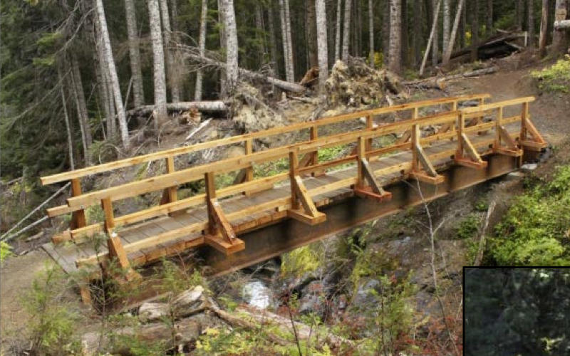
Here's the old bridge on the Heliotrope Ridge trail in October 2009, and the new bridge just after completion in July 2010:
Some Google searching turned up the construction contract and drawings:
Grouse Creek Trail Bridge, Mt Baker Ranger District
www.fbo.gov/index?s=opportunity&mode=for...89&tab=core&_cview=1
$30,400!
Here's the old bridge on the Heliotrope Ridge trail in October 2009, and the new bridge just after completion in July 2010:
Please Log in or Create an account to join the conversation.
- garyabrill
- [garyabrill]
-
Topic Author
- Offline
- Senior Member
-
Less
More
- Posts: 464
- Thank you received: 0
11 Apr 2011 19:48 #199677
by garyabrill
Replied by garyabrill on topic Re: Forest Serv. replaces bridge w/ pile of snowballs
Gone, I dunno, at this point I can only confirm that it is missing...... ")
Please Log in or Create an account to join the conversation.
- Alan Brunelle
- [BigSnow]
-
- Offline
- Senior Member
-
Less
More
- Posts: 260
- Thank you received: 0
12 Apr 2011 07:56 #199680
by Alan Brunelle
Replied by Alan Brunelle on topic Re: Forest Serv. replaces bridge w/ pile of snowballs
I wonder if it isn't time to design a bridge that can be removed and set aside in the winter that meets the needs for summer hikers and put in place a cheaper bridge that is expendable for winter months. Or some other solution, given some thought.
I remember having to cross the log of death a few years ago and would rather not have to do that again.
Alan
I remember having to cross the log of death a few years ago and would rather not have to do that again.
Alan
Please Log in or Create an account to join the conversation.
- Pinch
- [Pinch]
-
- Offline
- Senior Member
-
Less
More
- Posts: 289
- Thank you received: 0
12 Apr 2011 08:01 #199681
by Pinch
Replied by Pinch on topic Re: Forest Serv. replaces bridge w/ pile of snowballs
$30,400 is absolutely ridiculous!! This is what is wrong with gov't spending in every single project today! I hope they don't rebuild...
Please Log in or Create an account to join the conversation.
- Pete A
- [Bud]
-
- Offline
- Senior Member
-
Less
More
- Posts: 431
- Thank you received: 0
12 Apr 2011 09:23 #199683
by Pete A
Replied by Pete A on topic Re: Forest Serv. replaces bridge w/ pile of snowballs
maybe someone should climb up a nearby tree and install a rope swing.
Please Log in or Create an account to join the conversation.
- garyabrill
- [garyabrill]
-
Topic Author
- Offline
- Senior Member
-
Less
More
- Posts: 464
- Thank you received: 0
12 Apr 2011 19:39 #199700
by garyabrill
Replied by garyabrill on topic Re: Forest Serv. replaces bridge w/ pile of snowballs
To the best of my knowledge this is only the second time the bridge has been taken out in the past twenty years. The crossing over Grouse Creek at this point would be very dangerous without a bridge. There was actually an accident a few years back that happened in a guided party where a client fell off the "bridge of death", was injured and had to be rescued.
Please Log in or Create an account to join the conversation.
- Alan Brunelle
- [BigSnow]
-
- Offline
- Senior Member
-
Less
More
- Posts: 260
- Thank you received: 0
15 Apr 2011 11:02 #199760
by Alan Brunelle
I remember that log "bridge of death". My son and I crossed it that year and I had to back off in the morning for fear. He seemed to have no problem, but I had too much coffee on the drive up and could not keep steady. I did not like it and we could not be so lucky that such a tree could fall to even get a new bridge of death formed.
I had thought of an aluminum bridge such as the army might use that could be dropped in place in the spring, yet removed when the snows come.
Also, maybe an alternate solution is to suspend a walkway in such a way that it any snow slides would flow underneath. I am not sure how high the snow is at that point now, but using this slide and the other as possible historic events, they could design one that is a foot or more higher. Given a proper design, even if the snow were to clip such a structure, it might deflect and be retrievable rather than destroyed.
Alan
Replied by Alan Brunelle on topic Re: Forest Serv. replaces bridge w/ pile of snowballs
The crossing over Grouse Creek at this point would be very dangerous without a bridge. There was actually an accident a few years back that happened in a guided party where a client fell off the "bridge of death", was injured and had to be rescued.
I remember that log "bridge of death". My son and I crossed it that year and I had to back off in the morning for fear. He seemed to have no problem, but I had too much coffee on the drive up and could not keep steady. I did not like it and we could not be so lucky that such a tree could fall to even get a new bridge of death formed.
I had thought of an aluminum bridge such as the army might use that could be dropped in place in the spring, yet removed when the snows come.
Also, maybe an alternate solution is to suspend a walkway in such a way that it any snow slides would flow underneath. I am not sure how high the snow is at that point now, but using this slide and the other as possible historic events, they could design one that is a foot or more higher. Given a proper design, even if the snow were to clip such a structure, it might deflect and be retrievable rather than destroyed.
Alan
Please Log in or Create an account to join the conversation.
- kurthicks
- [kurthicks]
-
- Offline
- New Member
-
Less
More
- Posts: 10
- Thank you received: 0
15 Apr 2011 11:22 #199761
by kurthicks
Replied by kurthicks on topic Re: Forest Serv. replaces bridge w/ pile of snowballs
When they were replacing the bridge a few years ago (with the first one in the photos above) after the old one broke, we were all accessing the north side by walking downstream from the bridge location for about 100' to where the little canyon ends, hopping easily across rocks and small logs, then trudging up the hill on the other side...not sketchy at all from what I remember and a fine alternative to rebuilding that bridge yet again.
Please Log in or Create an account to join the conversation.
- Pinch
- [Pinch]
-
- Offline
- Senior Member
-
Less
More
- Posts: 289
- Thank you received: 0
10 Oct 2011 09:52 #201989
by Pinch
Replied by Pinch on topic Re: Forest Serv. replaces bridge w/ pile of snowballs
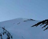
I don't really know what to make of this photo. I can't say that I have seen anything like it before. This photo was taken September 28th, 2011. 5+ months after the big Grouse Cr. avalanche, in which this was the start zone. Could it be possible that this is a remnant of the start of that slide, including crown line and stauchwall?? It's remarkable that any crown (on such a slope) is still evident this late in the season, whenever it happened. Was it hidden under subsequent snowfall, only to reemerge half a year later!!? After looking with binoculars, I discounted the thought that it was a glide crack crevasse, which sometimes occur on the ridge lookers left.
Please Log in or Create an account to join the conversation.
- Gregg_C
- [Gregg_C]
-
- Offline
- Junior Member
-
Less
More
- Posts: 149
- Thank you received: 0
10 Oct 2011 16:07 - 10 Oct 2011 16:11 #201993
by Gregg_C
Replied by Gregg_C on topic Re: Forest Serv. replaces bridge w/ pile of snowballs
Toby,
I saw that when I was skinning up in the half light just prior to dawn in late March when Louie and I did the Watson. Scared the piss out of me as I didn't know if it was recent. (Day before?, that night?--Definately got my attention). As the light increased I saw the crown line (six feet) and the debris a quarter mile down slope. Big chunks of debris where under 2-3 feet of snow. I don't think this was part of the big slide that took out the bridge, which would explain its continued appearance in the snow pack.
I saw that when I was skinning up in the half light just prior to dawn in late March when Louie and I did the Watson. Scared the piss out of me as I didn't know if it was recent. (Day before?, that night?--Definately got my attention). As the light increased I saw the crown line (six feet) and the debris a quarter mile down slope. Big chunks of debris where under 2-3 feet of snow. I don't think this was part of the big slide that took out the bridge, which would explain its continued appearance in the snow pack.
Please Log in or Create an account to join the conversation.
- Amar Andalkar
- [andalkar]
-
- Offline
- Premium Member
-
Less
More
- Posts: 635
- Thank you received: 0
23 Jul 2013 16:05 #210222
by Amar Andalkar
Most of us are very good at criticizing the USFS (or NPS, or most other government agencies) whenever anything goes wrong or contrary to our wishes on any of the areas that they administer. However, somehow we find it much harder to give plaudits to those same agencies when such praise is appropriate and due. As it is in this case.
I didn't realize it until I saw a random picture today, but the USFS used money from recreation fees (the much-reviled Northwest Forest Pass) to salvage, reinstall, and repair this Grouse Creek bridge during August 2012.
This is how things looked as of July 2012, with the bridge still destroyed since the April 2011 avalanche (quoted from Lowell's report: July 6-7, 2012, Mount Baker, Coleman Route , since I did not ski the C-D route or take photos of the bridge site during 2012):
And this is the random photo from May 2013 which made me realize today that the bridge had been unexpectedly repaired:
(from foursquaremountaineering.blogspot.com/20.../mt-baker-51113.html)
I had not previously heard that this bridge had been repaired, but some searching on WTA turned up this report (www.wta.org/go-hiking/trip-reports/trip_...012-09-02.8563713255) which indicates the bridge was repaired at the end of August 2012. And a bit of Google searching turned up this PDF file, Mt. Baker-Snoqualmie National Forest: Fee Accomplishment Report 2012 , which states, "Demolished by an avalanche, this bridge over Heliotrope Creek was salvaged and repaired with recreation fees." Image cropped from the PDF file:
See www.fs.usda.gov/detail/mbs/passes-permit.../?cid=fsbdev2_026999 for links to similar PDFs for each year since 2003 for most National Forests in the Pacific Northwest.
It's great to actually see for real that this money (at least some portion of it) is being spent for tangible improvements and benefits to important recreation access routes.
Replied by Amar Andalkar on topic Re: Forest Serv. replaces bridge w/ pile of snowballs
So the nice new steel and timber bridge built in June-July 2010 is gone, eh?
Some Google searching turned up the construction contract and drawings:
Grouse Creek Trail Bridge, Mt Baker Ranger District
www.fbo.gov/index?s=opportunity&mode=for...89&tab=core&_cview=1
$30,400!
Here's the old bridge on the Heliotrope Ridge trail in October 2009, and the new bridge just after completion in July 2010:
Most of us are very good at criticizing the USFS (or NPS, or most other government agencies) whenever anything goes wrong or contrary to our wishes on any of the areas that they administer. However, somehow we find it much harder to give plaudits to those same agencies when such praise is appropriate and due. As it is in this case.
I didn't realize it until I saw a random picture today, but the USFS used money from recreation fees (the much-reviled Northwest Forest Pass) to salvage, reinstall, and repair this Grouse Creek bridge during August 2012.
This is how things looked as of July 2012, with the bridge still destroyed since the April 2011 avalanche (quoted from Lowell's report: July 6-7, 2012, Mount Baker, Coleman Route , since I did not ski the C-D route or take photos of the bridge site during 2012):
Tom at the site of the Grouse Creek bridge:

The bridge was tossed 100 feet into the forest. (The perspective in this picture makes the bridge look smaller than it is.)

And this is the random photo from May 2013 which made me realize today that the bridge had been unexpectedly repaired:
(from foursquaremountaineering.blogspot.com/20.../mt-baker-51113.html)
I had not previously heard that this bridge had been repaired, but some searching on WTA turned up this report (www.wta.org/go-hiking/trip-reports/trip_...012-09-02.8563713255) which indicates the bridge was repaired at the end of August 2012. And a bit of Google searching turned up this PDF file, Mt. Baker-Snoqualmie National Forest: Fee Accomplishment Report 2012 , which states, "Demolished by an avalanche, this bridge over Heliotrope Creek was salvaged and repaired with recreation fees." Image cropped from the PDF file:
See www.fs.usda.gov/detail/mbs/passes-permit.../?cid=fsbdev2_026999 for links to similar PDFs for each year since 2003 for most National Forests in the Pacific Northwest.
It's great to actually see for real that this money (at least some portion of it) is being spent for tangible improvements and benefits to important recreation access routes.
Please Log in or Create an account to join the conversation.
- Pinch
- [Pinch]
-
- Offline
- Senior Member
-
Less
More
- Posts: 289
- Thank you received: 0
24 Jul 2013 07:46 #210228
by Pinch
Replied by Pinch on topic Re: Forest Serv. replaces bridge w/ pile of snowballs
....just an addition. Glacier Creek Road is CLOSED. No schedule for repair.
Please Log in or Create an account to join the conversation.
- Gregg_C
- [Gregg_C]
-
- Offline
- Junior Member
-
Less
More
- Posts: 149
- Thank you received: 0
24 Jul 2013 08:02 #210229
by Gregg_C
Replied by Gregg_C on topic Re: Forest Serv. replaces bridge w/ pile of snowballs
Word on the street is that if there is money left over from the Canyon Creek repair this summer it will be applied and used for the Glacier Creek repair. However, if Canyon Creek is any indication it could be awhile before the north side of Baker is open again. Probably going to be even harder getting money given the current "starve the beast" mentality of our current congress.
Please Log in or Create an account to join the conversation.
- Andrew Carey
- [acarey]
-

- Offline
- Elite Member
-

Less
More
- Posts: 912
- Thank you received: 0
26 Jul 2013 06:52 - 26 Jul 2013 06:57 #210241
by Andrew Carey
LOL. Just think, you could make a fortune if you would build such bridges for $3,400 and only charge the FS for $15,000, fully installed; more than 100% ROI; how can you resist. FS & NPS need lots of bridges on trail; you could easily get contracts for 3/wk for 3 summer months = $140,000+ for 3 months; go for it! Join the 1%! Once in business, you could go south as days shorten to do even more business.
Replied by Andrew Carey on topic Re: Forest Serv. replaces bridge w/ pile of snowballs
$30,400 is absolutely ridiculous!! This is what is wrong with gov't spending in every single project today! I hope they don't rebuild...
LOL. Just think, you could make a fortune if you would build such bridges for $3,400 and only charge the FS for $15,000, fully installed; more than 100% ROI; how can you resist. FS & NPS need lots of bridges on trail; you could easily get contracts for 3/wk for 3 summer months = $140,000+ for 3 months; go for it! Join the 1%! Once in business, you could go south as days shorten to do even more business.
Please Log in or Create an account to join the conversation.
- Gary Vogt
- [vogtski]
-
- Offline
- Premium Member
-
Less
More
- Posts: 511
- Thank you received: 8
26 Jul 2013 13:24 #210242
by Gary Vogt
Replied by Gary Vogt on topic Re: Forest Serv. replaces bridge w/ pile of snowballs
Actually, $30K seems a relative bargain compared to National Park trail bridges. Olympic built similar bridges at around $50,000 in 1990's dollars as well as larger trail bridges costing well over a hundred grand when I worked there. Several of them were under-engineered and wrecked by snow within a few years. I heard Mt. Rainier lost a six-figure bridge to an avalanche at Maple Falls (Stevens Canyon) in it's first winter, then doubled down on the replacement. Olympic is finishing up a trail suspension bridge in designated Wilderness near Staircase that will cost well over a million dollars!
NPS management is so out of touch with fiscal reality, they have proposed spending $7.4 million for a bear-viewing bridge for the 1% at Katmai, a park that costs over a thousand bucks in charter flights to reach from Anchorage:
www.nationalparkstraveler.com/2013/02/na...i-national-park22823
NPS management is so out of touch with fiscal reality, they have proposed spending $7.4 million for a bear-viewing bridge for the 1% at Katmai, a park that costs over a thousand bucks in charter flights to reach from Anchorage:
www.nationalparkstraveler.com/2013/02/na...i-national-park22823
Please Log in or Create an account to join the conversation.