- Posts: 635
- Thank you received: 0
Avalanche on "safe" route at Pan Point, Mt Rainier
- Amar Andalkar
- [andalkar]
-
 Topic Author
- Offline
- Premium Member
-

Less
More
01 Mar 2012 17:17 #101404
by Amar Andalkar
Avalanche on "safe" route at Pan Point, Mt Rainier was created by Amar Andalkar
Some interesting photos of recent avalanche crowns from the February 21 extreme-danger avalanche cycle were posted a couple of days ago on the Rainier climbing blog: mountrainierclimbing.blogspot.com/2012_02_01_archive.html
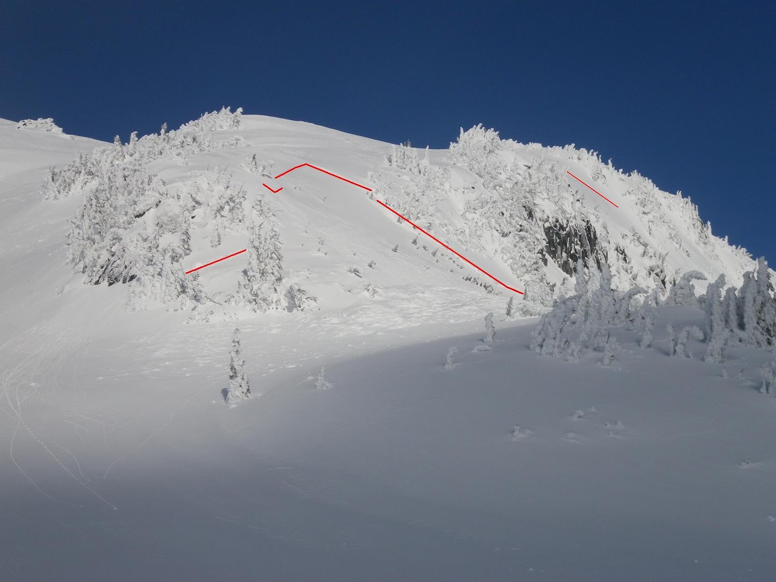
Most notably, at Panorama Point "the alternate/winter route experienced some activity":

[size=small](click for double-size version)[/size]
This is on a south aspect, slope angle of about 40 degrees (see topo map centered on that slope ). The highest part of the crown is at about 6600 ft (a convex roll where the slope angle increases from about 30 degrees to 40 degrees) and the debris pile is at about 6400 ft. It looks like a soft slab of the most recent storm snow, since the avalanche debris did not travel past the base of the slope, so it couldn't have been moving too fast. Still more than enough debris to bury someone, or an entire party traveling too close together.
The area which slid is along (what is considered to be) an avy-safer alternative to the standard snow route up the middle of Panorama Face (at left edge of photo), which goes up a classic avalanche slope that has been the location of previous avalanche accidents, including at least 1 fatality. Another route variation that is preferable to the standard route stays along the rightmost edge of Pan Face just below the trees, then cuts sharply right through one of several gaps in the trees to gain the SW ridge of Panorama Point near 6600 ft, on a moderate slope somewhat above the top of the crown in the photo.
Here is the archived NWAC avalanche forecast and danger rose for Tuesday, Feb 21: www.nwac.us/archive/sabsea_2012-02-21-1225.html
http://www.nwac.us/dangerrose/preview/2719/
With avalanche conditions that dangerous, clearly even a relatively "avy-safe" route can produce a substantial slide. There is no safe route to Camp Muir in conditions like that.
Most notably, at Panorama Point "the alternate/winter route experienced some activity":
[size=small](click for double-size version)[/size]
This is on a south aspect, slope angle of about 40 degrees (see topo map centered on that slope ). The highest part of the crown is at about 6600 ft (a convex roll where the slope angle increases from about 30 degrees to 40 degrees) and the debris pile is at about 6400 ft. It looks like a soft slab of the most recent storm snow, since the avalanche debris did not travel past the base of the slope, so it couldn't have been moving too fast. Still more than enough debris to bury someone, or an entire party traveling too close together.
The area which slid is along (what is considered to be) an avy-safer alternative to the standard snow route up the middle of Panorama Face (at left edge of photo), which goes up a classic avalanche slope that has been the location of previous avalanche accidents, including at least 1 fatality. Another route variation that is preferable to the standard route stays along the rightmost edge of Pan Face just below the trees, then cuts sharply right through one of several gaps in the trees to gain the SW ridge of Panorama Point near 6600 ft, on a moderate slope somewhat above the top of the crown in the photo.
Here is the archived NWAC avalanche forecast and danger rose for Tuesday, Feb 21: www.nwac.us/archive/sabsea_2012-02-21-1225.html
http://www.nwac.us/dangerrose/preview/2719/
With avalanche conditions that dangerous, clearly even a relatively "avy-safe" route can produce a substantial slide. There is no safe route to Camp Muir in conditions like that.
Please Log in or Create an account to join the conversation.
- Andrew Carey
- [acarey]
-

- Offline
- Elite Member
-

Less
More
- Posts: 912
- Thank you received: 0
01 Mar 2012 18:28 #101411
by Andrew Carey
Replied by Andrew Carey on topic Re: Avalanche on "safe" route at Pan Point, Mt Rainier
Did you see the waffle? I was in the parking lot when Carrie yelled out window "we're cooking waffles; you're welcome to come; no kidding!" I should have took her up on the offer, but I just finished buckling my boots.
When I (and Robie, and Vogtski, and Jeff, and Ed) was up there Monday?, I skinned up from 4th Xing to the back bowl and and was blown away by the fracture lines on all aspects! Most avy activity I've ever seen above Paradise.
When I (and Robie, and Vogtski, and Jeff, and Ed) was up there Monday?, I skinned up from 4th Xing to the back bowl and and was blown away by the fracture lines on all aspects! Most avy activity I've ever seen above Paradise.
Please Log in or Create an account to join the conversation.
- Gary Vogt
- [vogtski]
-
- Offline
- Premium Member
-
Less
More
- Posts: 511
- Thank you received: 8
01 Mar 2012 18:34 #101412
by Gary Vogt
Replied by Gary Vogt on topic Re: Avalanche on "safe" route at Pan Point, Mt Rainier
Monday there were still crown fractures visible all around the Mazama 'back bowl', both south and north aspects. Many of the slides from this cycle here and in Paradise Valley also had very short travel distances and a couple almost looked like large slumps or glide cracks.
There was a much larger avalanche with fifteen feet deep deposition at the Dry Creek summer parking lot on the Westside Road. This slide ran over a mile and three thousand vertical feet off Mt Wow.
There was a much larger avalanche with fifteen feet deep deposition at the Dry Creek summer parking lot on the Westside Road. This slide ran over a mile and three thousand vertical feet off Mt Wow.
Please Log in or Create an account to join the conversation.
- CookieMonster
- [CookieMonster]
-
- Offline
- Senior Member
-

Less
More
- Posts: 392
- Thank you received: 0
04 Mar 2012 23:21 #101544
by CookieMonster
Replied by CookieMonster on topic Re: Avalanche on "safe" route at Pan Point, Mt Rainier
I'm very surprised to hear that anyone thinks the route indicated is "safer"!
Please Log in or Create an account to join the conversation.
- bc_skier
- [bc_skier]
-
- Offline
- Junior Member
-

Less
More
- Posts: 69
- Thank you received: 0
07 Mar 2012 01:59 #101635
by bc_skier
Replied by bc_skier on topic Re: Avalanche on "safe" route at Pan Point, Mt Rainier
Dito...any slope between 30 - 45 degrees (with snow on it) has the potential to slide in the right conditons.
Please Log in or Create an account to join the conversation.
- Oyvind_Henningsen
- [Oyvind_Henningsen]
-
- Offline
- Junior Member
-
Less
More
- Posts: 62
- Thank you received: 0
07 Mar 2012 11:25 #101652
by Oyvind_Henningsen
Replied by Oyvind_Henningsen on topic Re: Avalanche on "safe" route at Pan Point, Mt Rainier
good observation, yeah that pocket under the roof of your a-frame gets super windloaded real fast during predominant wind direction at that place. my opinion is that it is possible to (if you have to) pick a safer route on this ridge feature, assuming good visibility as the feature goes in between the two slabs that have pulled out. the ridge is not big and it requires local knowledge to thread the needle. of course if this is the situation you are electing to be in (going up) you have to ask yourself WHY am I here right now? if you are choosing this route as a good habit wise travel practice instead of herding up the big slope to the left on a deemed 'stable' day, then kudos.
Please Log in or Create an account to join the conversation.
- nhluhr
- [nhluhr]
-
- Offline
- New Member
-

Less
More
- Posts: 6
- Thank you received: 0
08 Mar 2012 14:28 #101694
by nhluhr
Replied by nhluhr on topic Re: Avalanche on "safe" route at Pan Point, Mt Rainier
the safer route is not 'indicated' on the photo. the indications on the photo are highlighting the fracture crown. The so-called safer route is through the trees on the left.I'm very surprised to hear that anyone thinks the route indicated is "safer"!
Please Log in or Create an account to join the conversation.