April 26, 2008, Enchantments Tour
4/26/08
WA Cascades East Slopes Central
6489
9
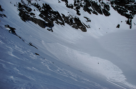
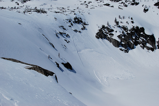
Six of us set out to ski Cannon Mt via Aasgard Pass, intending to more or less follow the route in this report by Ryanl. I skied the Cannon Couloir two weeks ago with another party member and the view of the runs down to Coney Lake was the motivation to return. Everything went smoothly until we started skiing down from Aasgard Pass to Prusik Pass when someone triggered and was caught in a wind slab on the steep NE facing slopes above Inspiration Lake. He was the first skier down the slope. The slide broke on his second or third turn and quickly propagated above him to the ski cut made by his first turn. He was caught and carried down with the debris but managed to stay on his feet. When the slide stopped, one of his legs and ski were buried to his shin. Neither of his skis released (non-releasable tele bindings) and other than being shaken up he was unharmed. He estimated the crown was 10-18" and the slide ran about 300 ft. The weak layer was wind loaded and sun warmed snow from earlier in the week above a melt freeze crust. The first photo is taken from above just after the slide; the black dot in the debris is the skier. The second is taken from about where the summer trail descends to the lake.
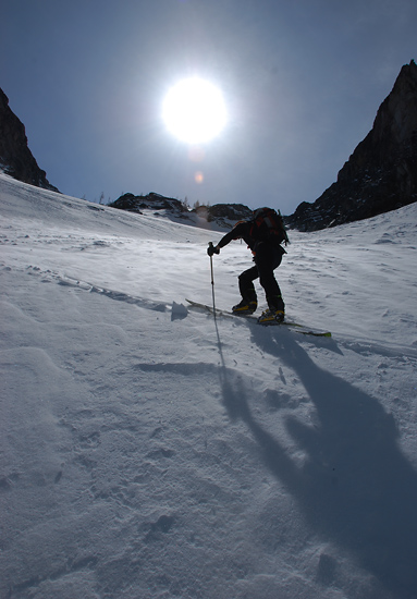
On the climb to Asagard Pass and beginning of the ski descent we ignored several warning signs. Winds were actively loading the slope below the pass, quickly filling the skin track (third photo). Several of us remarked that the skinning was difficult because the new snow slid easily on the old crust. It was quite hot in the upper Enchantments once out of the wind. We did not dig a pit.
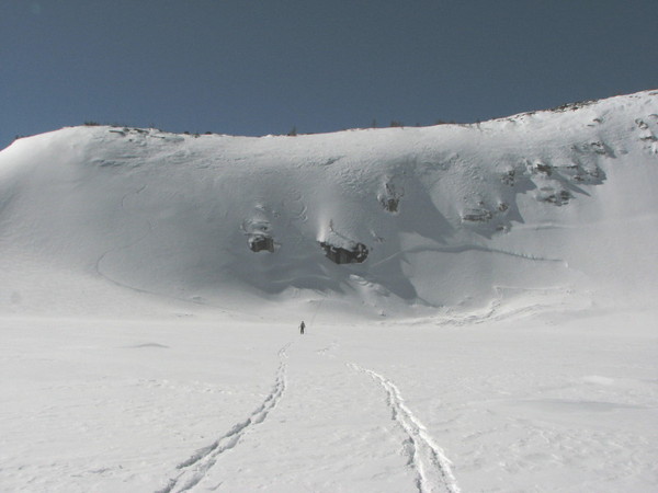
After the slide, we had a conference in the middle of the lake. We decided not to climb Cannon because the steep couloirs down to Coney Lake have the same exposure as the avalanche and are unavoidable. We were somewhat concerned about the snow below Aasgard and no one wanted return this way. Instead, we decided to ski down past Shield and Earle Lakes and follow benches up to Cannon's north ridge above Coney Lake.
The ski descent and climb to Coney Lake across the Lost World Plateau were very scenic and enjoyable. We underestimated the time it would take to do the alternate route (mistake #2) which was compounded by a route finding error by not having a good map (mistake #3; we were using a Green Trails map, but should have had the USGS map). We started racing the sun down from Cannon's N ridge, but shortly thereafter a binding broke. I had a repair kit, but the repair cost us some time. Finally, the best descent route is not obvious and we found ourselves in thick trees as it got dark. We finally made it back to the car some time after 10 pm, tired but happy to have avoided a full blown epic. Whew!
On the climb to Asagard Pass and beginning of the ski descent we ignored several warning signs. Winds were actively loading the slope below the pass, quickly filling the skin track (third photo). Several of us remarked that the skinning was difficult because the new snow slid easily on the old crust. It was quite hot in the upper Enchantments once out of the wind. We did not dig a pit.
After the slide, we had a conference in the middle of the lake. We decided not to climb Cannon because the steep couloirs down to Coney Lake have the same exposure as the avalanche and are unavoidable. We were somewhat concerned about the snow below Aasgard and no one wanted return this way. Instead, we decided to ski down past Shield and Earle Lakes and follow benches up to Cannon's north ridge above Coney Lake.
The ski descent and climb to Coney Lake across the Lost World Plateau were very scenic and enjoyable. We underestimated the time it would take to do the alternate route (mistake #2) which was compounded by a route finding error by not having a good map (mistake #3; we were using a Green Trails map, but should have had the USGS map). We started racing the sun down from Cannon's N ridge, but shortly thereafter a binding broke. I had a repair kit, but the repair cost us some time. Finally, the best descent route is not obvious and we found ourselves in thick trees as it got dark. We finally made it back to the car some time after 10 pm, tired but happy to have avoided a full blown epic. Whew!
Glad everything turned out okay, Matt!
In your second picture, it looks like the slide started at one of the steeper locations in the picture. I presume you descended a different way. Did you get a sense of how terrain-sensitive the hazard was? An important lesson could be the choice of slopes to descend. I don't mean to criticize--I hope to learn something too.
In your second picture, it looks like the slide started at one of the steeper locations in the picture. I presume you descended a different way. Did you get a sense of how terrain-sensitive the hazard was? An important lesson could be the choice of slopes to descend. I don't mean to criticize--I hope to learn something too.
wow matt, glad to hear you guys are alright. that's a big looking slide!
Amazing that a tooth of slab on the lower looker's right is still intact.
Amazing that a tooth of slab on the lower looker's right is still intact.
Thanks for posting the TR, Matt. I'm the dot in the middle of the slide in the top pic, and am hoping to learn from this experience. If you can't learn from something like this, then you can't learn.
Approximately what's the elevation there? I'm not to familiar with this area, just curious for some statistics. I feel that everyone in this community learns something when someone shares this type of experience.
Very glad you all were okay. Especially with non release bindings in all of that slide -- whew!
Ryan or Dave C can correct me if I'm not remembering, but the location of your slide is where we saw evidence of a natural slide likely a day or so before we all did that Cannon tour. So we ended up skiing further skier's right, it was still steep but not as much of a roll over towards the bottom. We had much colder temps, every item of clothing I had on top of Asgaard pass wasn't quite enough.
the pics of Dave skiing down to Inspiration lake on Ryan's cc report don't show that part of said slope. maybe i can figure out how to thumbnail a wider shot...
author=Monika link=topic=9908.msg39934#msg39934 date=1209424213]
So we ended up skiing further skier's right, it was still steep but not as much of a roll over towards the bottom. We had much colder temps, every item of clothing I had on top of Asgaard pass wasn't quite enough.
the pics of Dave skiing down to Inspiration lake on Ryan's cc report don't show that part of said slope. maybe i can figure out how to thumbnail a wider shot...
I had a look at your TR. The pic of Dave (?) skiing down towards the lake does show the same slope, just over a bit to looker's left (you can see the little larch tree on top of the rock in both pics). But the steepness, slope shape, etc. were basically the same. In fact, I originally traversed to skier's left (right in the pic) to avoid the rocks and ski a less steep line than the one in your pic (the difference ended up being minimal - I'd guess 1 degree or so, tops, between the two sections). I'm fairly sure about that because I spent a while both looking down from above and then looking up at the whole thing afterwards, and yelled to the others not to ski down that way because it looked just as steep and prone to sliding. Your snow conditions were clearly very different; time of day, etc. would have had an effect as well. There may have been localized effects on that part of the slope (more wind-loading?) that made it more prone than further left (climber's left), but I don't know.
In any case, ya, I was pretty happy to be in one piece at the bottom. Had to get my shovel out to dig out my right foot and ski, but that was it. The rest of the day became really exhausting, although it was very scenic. Lots of time to reflect on everything. The massive adrenaline dose took a lot out of me too, as just before the slide I was feeling great, and afterwards not so much. Understandable, I guess.
I don't have the map in front of me, but I think Inspiration lake is at about 7000 feet.
author=DP link=topic=9908.msg39944#msg39944 date=1209432680]
I had a look at your TR. The pic of Dave (?) skiing down towards the lake does show the same slope, just over a bit to looker's left (you can see the little larch tree on top of the rock in both pics). But the steepness, slope shape, etc. were basically the same. In fact, I originally traversed to skier's left (right in the pic) to avoid the rocks and ski a less steep line than the one in your pic (the difference ended up being minimal - I'd guess 1 degree or so, tops, between the two sections). I'm fairly sure about that because I spent a while both looking down from above and then looking up at the whole thing afterwards, and yelled to the others not to ski down that way because it looked just as steep and prone to sliding. Your snow conditions were clearly very different; time of day, etc. would have had an effect as well. There may have been localized effects on that part of the slope (more wind-loading?) that made it more prone than further left (climber's left), but I don't know.
I'm glad you're OK. Must have been quite a scare.
In the picture above, Dave skied to the far climber's left, Monika and I skied just to the left of the tree, and you skied thru the rock bands off to the far right. When I approached those slopes I did the same as you. It looks like things weren't quite as filled in as when you did it, so my choice was easier. But I remember seeing a roll at the top that continued along the ridge to my left. So I ended up traversing to the skier's right until I found a place without convexity. (From personal experience ;) ) I generally stay away from rolls unless I've climbed them on the way up and feel good about their stability) Nice job though on finding an alternate route back to the car once you realized conditions were different than you expected.
And Monika, good memory about the slide off to the side! I'd forgotten about that.
Matt et al., Glad to hear you guys are OK.
Thanks everyone for the discussion. Ryan, I really like your picture since it shows just how much that slope gets wind loaded. I think the snow on this exposure was generally unstable this day -- we were able to easily get other much smaller test slopes to slide on the way to Prusik Pass. But, this slide was certainly avoidable by better terrain selection. My second picture was taken where the rest of us skied down to the lake out of view to the lookers left in Ryan's photo. The terrain here is much lower angled. We crossed the ridge about where Ryan and Monica skied, and since the slope rolls away steeply we couldn't see below or to the skier's right. We could see a clear way through by traversing left and did so, triggering the slide. At the time, I wasn't concerned about avalanches, just finding a way through the rocks (and think this feeling was shared among the group).
Looking back, I'm surprised at how complacent I was about the snow conditions. This was by far the largest human triggered avalanche I have seen. But, my accumulated experience of several hundred backcountry days in all snow conditions, skiing in similar snow conditions or on similar slopes without consequence tricked me into thinking that, at least on this day, I didn't need to worry. When I first started backcountry skiing, I was super anxious about the snow pack. The main take home message for me is that some of this fear is OK because it forces me to be on my toes.
Looking back, I'm surprised at how complacent I was about the snow conditions. This was by far the largest human triggered avalanche I have seen. But, my accumulated experience of several hundred backcountry days in all snow conditions, skiing in similar snow conditions or on similar slopes without consequence tricked me into thinking that, at least on this day, I didn't need to worry. When I first started backcountry skiing, I was super anxious about the snow pack. The main take home message for me is that some of this fear is OK because it forces me to be on my toes.
Reply to this TR
Please login first: