April 13, 2008, University Peak,NE Gulley
4/13/08
2317
0
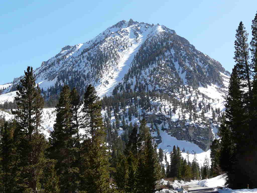
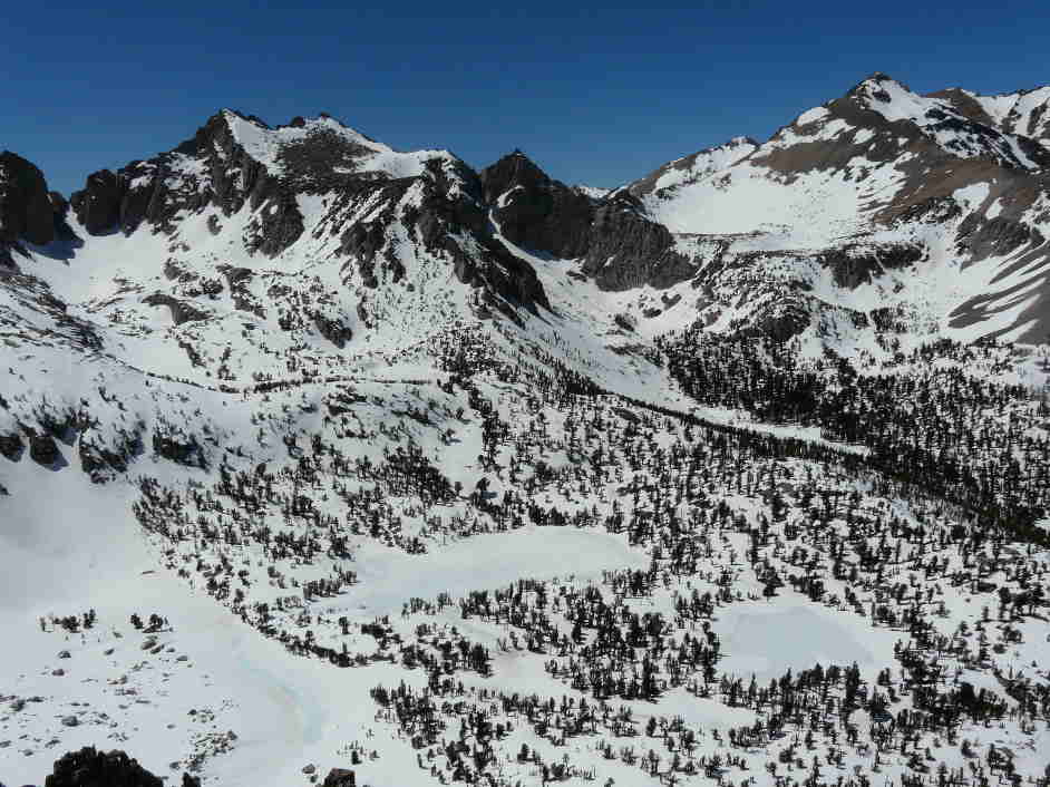
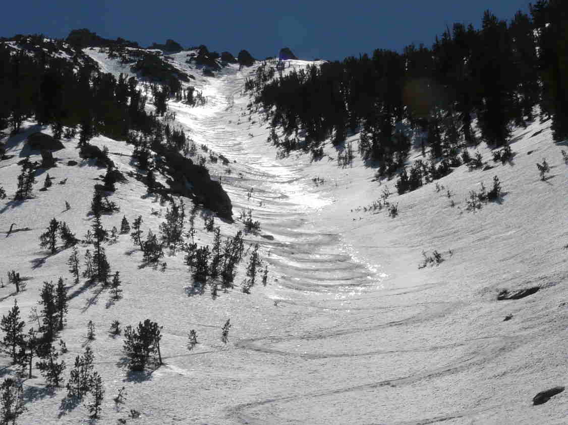
The previous afternoon we drove to Independence at 3900', then drove west on the Onion Valley Road 13 miles to its terminus at 9200'. Last summer a fire roared up the hillsides and there is a stark beauty in the charred old trees that remain along the landscape. At Seven Pines, the road is officially closed but not gated. About 2 weeks ago, I had to turn around here due to the roadway being blocked by boulders that littered the road. Today, the road still had rockfall littering the pavement, but some kind soul(s) had cleared a path for a vehicle. It is another 7 miles along a serpentine paved road with sections of rockfall to the terminus. We passed the east gulley of Independence Peak which we had skied in May 2005, and there was good coverage along the dogleg route. As we approached the terminus a few snowbanks encroached the road and then we saw the first view of the NE gulley of University Peak at 13,630'. I pulled out the binoculars and there was excellent coverage along the entire route and not a track on the surface. The NE gulley is what I call low-hanging fruit whereas the more famous North Couloir is longer, but requires sooooo much more effort to reach. It was Saturday and there were only 5 cars at the parking circle. I think the word on road access hasn't gotten out much yet. As evening approached the owners of the 5 other vehicles descended, and it appeared to be a guided group who toured near Kearsarge Pass. When we awoke the next morning the guided group of guys were already out touring. We put the skins on 10 yards from the campervan and started the ascent towards the base of the gulley. The sun was softening the slope and it was going to be a hot day. It's about 600vf to the base of the gulley and another 1800vf to the top. The slope varies from 35 to 42 degrees and is perfectly shaped for skiing or riding. We put on the ski crampons and they were useful on the firmer surfaces on climbers left. We experienced consolidated corn on climbers right, soft mush with a ski penetration of 6" in the center and a firm surface on climbers left. The variable snow surfaces narrowed the climbing track as the steepness increased. We seemed to slow down above 11,000' and it was apparent that the elevation was having an effect. The gulley tops out at 11,600', and we were able to peer down to the base of the North Couloir, Kearsarge Pass, Mt. Gould, Dragon Peak, Kearsarge Peak and several of the lakes in the area. Many of the upper peaks are wind scoured, but lower slopes are still snow covered. It's always enjoyable to be at elevation in a world of snow and then to look east towards Independence which is surrounded by sagebrush. The descent was on a soft mushy surface for about 100' which required a combination of kick and jump turns. I ski cut a portion of the slope and triggered a slow moving slushy that ran ever so slowly for about 500'. After the top 100' we were able to ski arcing turns on skier right on an inch of corn on a firm base, or cross over the mush in the center to skier left and arc turns on consolidated corn. Although the gulley is only 1800', it seemed to be long descent - not the relaxing turns in Sierra corn that we'd hoped for. At the base, we could look back up at our tracks glistening in the sun. Once back to the camper there was no one around to swap ski stories. We setup our solar shower and washed off the sweat from the climb enjoying the sun and no breeze. Then we opened a cold one and relaxed - tired but satisfied with ourselves. On our drive down, we stopped at the northern most hairpin turn, which is the parking spot for the descent down Sardine Canyon. For years I've been interested in seeing how far you have to walk from Sardine Canyon along the deserted mining road back to a car shuttle. I started the walk and after 25 minutes I arrived at what appeared to be the exit slope which was partially snow covered with debris and sage poking through and suncupped where snow existed. It certainly didn't look promising, but perhaps the exit canyon was still further down the road.... My feet were sore and I turned around. The ski tour up to Kearsarge Peak with the descent down Sardine Canon has always seemed appealing because you climb about 3000vf and descend 5000vf. But then you have the walk a long ways along the road and need a car shuttle, plus you are descending a route you haven't climbed and may run out of the snow before the dirt road. We decided to descend to a campsite along Independence Creek where we relaxed with another good, cold beer.
Reply to this TR
Please login first: