12/8 Pineapple pass -Terrible skiing; good weather
12/8/07
WA Snoqualmie Pass
2414
0
Summary: Terrible skiing. But fun playing in the snow. Avalanche debris on most slopes >25degrees. 1-2" of new snow >4500ft.
I had hoped to go up to Camp Muir this Saturday. But I didn't manage to find anyone to share the ride with. As I woke up on Saturday I felt a need to get some turns in, but going on my own I decided to stay close to home and avoid anyplace which might involve unpredictable snow conditions or risk of navigational mishaps.
So I headed up to Snoqualmie Pass. I drove by Summit West and noticed they had a lift running. I don't know if it was for the public or just for employees (patrollers, lifties, instructors) to do some training. Since I didn't feel like skinning up among the crowds on the Summit West slopes I turned right towards Alpental.
The snow on the Alpental slopes looked bad, so I started skinning up towards Source Lake instead. The snow was rock solid. I kept my skis on except when crossing a few streams, but in retrospect it would have been faster, easier and better or the skis to just walk with them on the backpack (that's what I did going out later).
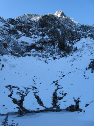
As I got to Source Lake it was obvious that there weren't any turns to be had there either (see the picture), so I headed up towards Pineapple Pass.
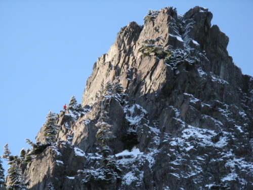
Pineapple Pass offered 10-15 turns on top of 1-2" of new snow covering avalanche debris. In short: terrible :-). I had lunch up here while watching two climbers descend the Tooth (see picture).
Since there was plenty of daylight left and I didn't think there'd be worthwhile skiing anywhere (as expected), I decided to go investigate something I have wondered about several times: Is there a simple way to follow the ridge from Pineapple Pass to the Alpental ski resort? I started by walking around the first peak on the ridge (5456ft) to the North/East. Then I hiked up to the ridge again to look around both sides of the next peak (5518ft?). I couldn't figure out a way to get around it which would feel safe without roping up, so gave up.
If anyone knows of a way to traverse that ridge with just hiking + skinning, I'd be interested to hear about it. Perhaps that becomes possible only with more snow? The only possible option I could see would be to drop down in the valley to the West and then hike up to the ridge again. But I wasn't quite in the mood for that kind of epic (and I'm sure the Alpental Security folks wouldn't have appreciated my car being left in their parking lot after dark).
Since I was already investigating the terrain around here, I decided to see if there might be a short-cut for getting down to the South Fork Snoqualmie River valley from the ridge without going all the way back to Source Lake. Walking in you see a few shutes which would be possible to descend with just crampons + ice axe. I had seen a group of 6-8 people practicing snow field belays in one of those shutes earlier in the day.
I walked down from the ridge to the point where the terrain turns vertical. Then I followed the topographical line between ~45degrees and steeper going north (since I'd eventually run into the shute which leads down to Source Lake that way). After ending up in a few situations where I wished I had a rope and more climbing gear to be able to really see if there might be a navigable shute below, I realized how much harder it is to find these shutes from above than it is to find them from below. So I gave up and hiked north and then down the shute towards Source Lake.
I headed out tired but happy and reached the car around 4.45pm. There were 3-4 other cars there and a Security guard waiting in car, presumably to ensure that there wouldn't be any cars left after dark, possibly indicating that someone might be in trouble.
I had hoped to go up to Camp Muir this Saturday. But I didn't manage to find anyone to share the ride with. As I woke up on Saturday I felt a need to get some turns in, but going on my own I decided to stay close to home and avoid anyplace which might involve unpredictable snow conditions or risk of navigational mishaps.
So I headed up to Snoqualmie Pass. I drove by Summit West and noticed they had a lift running. I don't know if it was for the public or just for employees (patrollers, lifties, instructors) to do some training. Since I didn't feel like skinning up among the crowds on the Summit West slopes I turned right towards Alpental.
The snow on the Alpental slopes looked bad, so I started skinning up towards Source Lake instead. The snow was rock solid. I kept my skis on except when crossing a few streams, but in retrospect it would have been faster, easier and better or the skis to just walk with them on the backpack (that's what I did going out later).
As I got to Source Lake it was obvious that there weren't any turns to be had there either (see the picture), so I headed up towards Pineapple Pass.
Pineapple Pass offered 10-15 turns on top of 1-2" of new snow covering avalanche debris. In short: terrible :-). I had lunch up here while watching two climbers descend the Tooth (see picture).
Since there was plenty of daylight left and I didn't think there'd be worthwhile skiing anywhere (as expected), I decided to go investigate something I have wondered about several times: Is there a simple way to follow the ridge from Pineapple Pass to the Alpental ski resort? I started by walking around the first peak on the ridge (5456ft) to the North/East. Then I hiked up to the ridge again to look around both sides of the next peak (5518ft?). I couldn't figure out a way to get around it which would feel safe without roping up, so gave up.
If anyone knows of a way to traverse that ridge with just hiking + skinning, I'd be interested to hear about it. Perhaps that becomes possible only with more snow? The only possible option I could see would be to drop down in the valley to the West and then hike up to the ridge again. But I wasn't quite in the mood for that kind of epic (and I'm sure the Alpental Security folks wouldn't have appreciated my car being left in their parking lot after dark).
Since I was already investigating the terrain around here, I decided to see if there might be a short-cut for getting down to the South Fork Snoqualmie River valley from the ridge without going all the way back to Source Lake. Walking in you see a few shutes which would be possible to descend with just crampons + ice axe. I had seen a group of 6-8 people practicing snow field belays in one of those shutes earlier in the day.
I walked down from the ridge to the point where the terrain turns vertical. Then I followed the topographical line between ~45degrees and steeper going north (since I'd eventually run into the shute which leads down to Source Lake that way). After ending up in a few situations where I wished I had a rope and more climbing gear to be able to really see if there might be a navigable shute below, I realized how much harder it is to find these shutes from above than it is to find them from below. So I gave up and hiked north and then down the shute towards Source Lake.
I headed out tired but happy and reached the car around 4.45pm. There were 3-4 other cars there and a Security guard waiting in car, presumably to ensure that there wouldn't be any cars left after dark, possibly indicating that someone might be in trouble.
Reply to this TR
Please login first: