September14. 2007, Chowder Ridge (had by Hadley)
9/14/07
3026
3
This trip was an example of what can happen if you have too many agendas.
1) Go on a nice ridge hike
2) Try and hit some kind of summit (Hadley)
3) Snoop around in the rocks to look for the "clams" on Chowder Ridge
4) September turns
Agenda #2 was the one that fell to the wayside, and partially #4 too, but I did get in about 800 ft of cuppy gully skiing for an around 20% JOM.
Plan A was to hit Hadley and hit a prominent gully I had seen from pictures that ran down almost 1000vf from a permanent snowpatch just on the climbers R of where Cougar Divide joined Chowder Ridge. But after seeing it in real life, it looked like it would have been dangerously undercut by the stream that was running under it.
I also decided to do this via Skyline rather than Cougar approach. Reasons: better road, better (though longer) trail, less bugs, better views.
The hours of the approach wore on and after 3 hours I was only as far as the tarn below Chowder R that many use as a camp when doing Hadley as a two day. Would guess 2 hours to Hadley from here perhaps more if the trail/track through the loose stuff on the backside wasn't good. I was feeling lazy and was getting quite tired of carrying ski gear along 5+ miles of dry ridge, so here I just skied another 400vf stream gully I'd seen that was downhill of the tarn and climbers right of the original target gully, hoping it wasn't too undercut. No one would ever seek out this run, it was just the snow of greatest convenience once motivation to go further had bonked.
Ended up deciding to run it twice and decided that rather than climbing back up I would sidehill back to the lower Chowder Basin trail. NOT recommended. Sidehill travel here is quite awkward. The soil is hard and compacted, and the heather and blueberry slippery. Had to make numerous ups and downs and spent probably more energy than I would have in reascending to the tarn and taking the trail out.
If you are there to climb Hadley, or for late summer skiing, should probably go Cougar so long as road is open. It's an annoying road, but not truly a bad road, and as for bugs I guess move fast. The Skyline is a minimum of 1.5 hrs longer each way and doesn't really put you into position to ski the snow that lingers on Chowder, whereas the Cougar ridge extends right by some of the viable snowfields, and also puts you in better position for the Hadley Glacier itself.
However, the Skyline approach is incredibly scenic and one of the best easy ridge runs I've done. If I had just scrubbed the skiing agenda I could have probably made it to Hadley and had fun. Ah well, it's September, and this TAY obsession exacts its price at times. Topping Hadley was that price. Next time ... and also mentally scouted Skyline for future June-ish trips. There'd be some steep sidehilling, but the various basins would be awesome about then.
Never did find any fossil clams. The Tabor guide isn't exact for where these are, and maybe I was in the wrong spots.
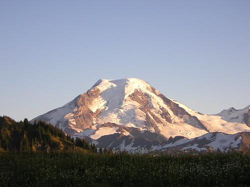
Baker and Chowder Ridge in evening light
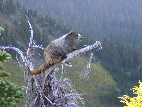
Crazed tree sitting marmot. What's crazier - a marmot sitting in a tree, or hauling skis 12 miles RT to ski a cuppy 400ft gully twice?
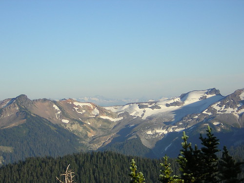
Recon photo for the Sholes Glacier, should have taken earlier in full sun. About half of Sholes is down to ice, and getting down from the ridge and across through the portals looks perhaps problematic.
1) Go on a nice ridge hike
2) Try and hit some kind of summit (Hadley)
3) Snoop around in the rocks to look for the "clams" on Chowder Ridge
4) September turns
Agenda #2 was the one that fell to the wayside, and partially #4 too, but I did get in about 800 ft of cuppy gully skiing for an around 20% JOM.
Plan A was to hit Hadley and hit a prominent gully I had seen from pictures that ran down almost 1000vf from a permanent snowpatch just on the climbers R of where Cougar Divide joined Chowder Ridge. But after seeing it in real life, it looked like it would have been dangerously undercut by the stream that was running under it.
I also decided to do this via Skyline rather than Cougar approach. Reasons: better road, better (though longer) trail, less bugs, better views.
The hours of the approach wore on and after 3 hours I was only as far as the tarn below Chowder R that many use as a camp when doing Hadley as a two day. Would guess 2 hours to Hadley from here perhaps more if the trail/track through the loose stuff on the backside wasn't good. I was feeling lazy and was getting quite tired of carrying ski gear along 5+ miles of dry ridge, so here I just skied another 400vf stream gully I'd seen that was downhill of the tarn and climbers right of the original target gully, hoping it wasn't too undercut. No one would ever seek out this run, it was just the snow of greatest convenience once motivation to go further had bonked.
Ended up deciding to run it twice and decided that rather than climbing back up I would sidehill back to the lower Chowder Basin trail. NOT recommended. Sidehill travel here is quite awkward. The soil is hard and compacted, and the heather and blueberry slippery. Had to make numerous ups and downs and spent probably more energy than I would have in reascending to the tarn and taking the trail out.
If you are there to climb Hadley, or for late summer skiing, should probably go Cougar so long as road is open. It's an annoying road, but not truly a bad road, and as for bugs I guess move fast. The Skyline is a minimum of 1.5 hrs longer each way and doesn't really put you into position to ski the snow that lingers on Chowder, whereas the Cougar ridge extends right by some of the viable snowfields, and also puts you in better position for the Hadley Glacier itself.
However, the Skyline approach is incredibly scenic and one of the best easy ridge runs I've done. If I had just scrubbed the skiing agenda I could have probably made it to Hadley and had fun. Ah well, it's September, and this TAY obsession exacts its price at times. Topping Hadley was that price. Next time ... and also mentally scouted Skyline for future June-ish trips. There'd be some steep sidehilling, but the various basins would be awesome about then.
Never did find any fossil clams. The Tabor guide isn't exact for where these are, and maybe I was in the wrong spots.
Baker and Chowder Ridge in evening light
Crazed tree sitting marmot. What's crazier - a marmot sitting in a tree, or hauling skis 12 miles RT to ski a cuppy 400ft gully twice?
Recon photo for the Sholes Glacier, should have taken earlier in full sun. About half of Sholes is down to ice, and getting down from the ridge and across through the portals looks perhaps problematic.
Nice photos & that is a crazy marmot.
I've thought that the road to Skyline Divide is washed out (again). How far did you get to the trailhead??
I've thought that the road to Skyline Divide is washed out (again). How far did you get to the trailhead??
The Skyline road is open all the way to the TH, has been since around Labor Day I think. That was another reason for going Skyline: it's been a while since it was even an option (Wells Cr hasn't been open that long either; since mid July. The road situation(s) probably why reports for Hadley have been few and far between lately.)
Kudos to the FS for fixing the road at all. However, it's a patch job, looks like even an average winter might wipe the reconstructed roadbed out again there (although I didn't see what they might have done to make a better culvert). Let's hope for the best, and if you go up there in Spring '08 perhaps be ready for some disappointment. The washout's real low (a crossing of Deadhorse Cr at not even 3000').
Kudos to the FS for fixing the road at all. However, it's a patch job, looks like even an average winter might wipe the reconstructed roadbed out again there (although I didn't see what they might have done to make a better culvert). Let's hope for the best, and if you go up there in Spring '08 perhaps be ready for some disappointment. The washout's real low (a crossing of Deadhorse Cr at not even 3000').
What route is usually taken from that tarn to access the ridge? I was up there today poking around and followed a path climber's right of that small pond. It led to the top of a couple gullies, but from there it faded and the route up to gain the main ridge wasn't obvious to me.
Reply to this TR
Please login first: