July 26-28, Mt Robson, Kain face
7/15/07
22604
14
I only have time for a quick crappy TR, but Ryan, me, and Sky ventured up to Canada for a few days of fun and expensive gas and beer.Robson Provincial park is about 800 miles from seattle by the route we took. It took us most of the day to get up there, thankfully with little hassle at the border.
The next day we hiked the twenty miles up to our campsite near exstinguir rock beside the Robson glacier (massive broken glacier), the approach envolved bueatifull vistas, circleing most of the way around the mountain, and an interseting creek crossing, (wich in hindsight could have been avoided).
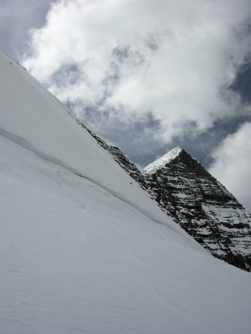
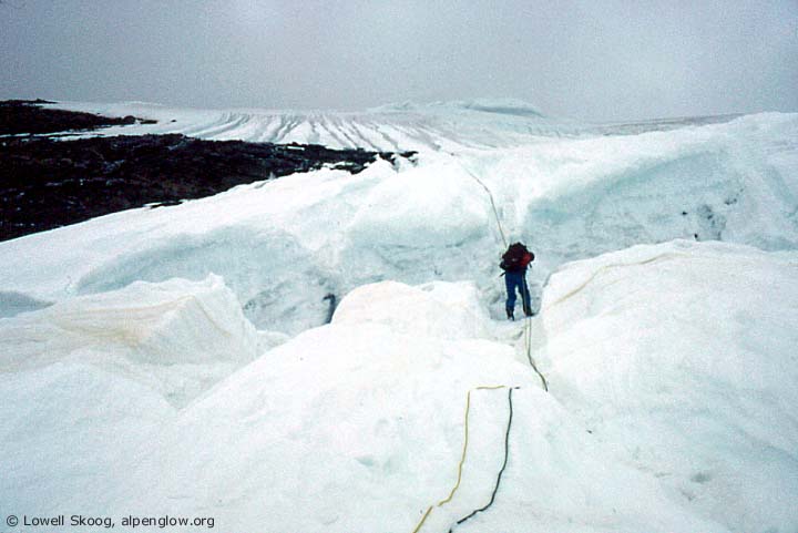
On the 27th we set out at a reasonable hour with the intention of negotiating the Heavily crevassed and undulating Robson glacier, up over a col, and then up the North face, which was the route we had planned for. The glaciar proved to be complex, and very broken, which slowed us down a little as we did not know the "standard and direct route" feeling our way up the glacier we decided to go direct and climb the north side of the Dome. The north side of the Dome was a very fun climb, starting with 45dg snow (and some bergshund crossings) which steepened as we went higher. The top of this was about ~150'? of 60-65dg wet alpine ice wich we free climbed. From the top of the Dome we we were not to far from the bottom of the Kain face. We charged the Kain face and were up farily quickly to our highpoint of ~11700, had a drink then clicked into our skiis. The face was ~50dg and about 1600' the snow was interesting and a little scary as it was about 6" of loose wet grains over various crusts, and ice in places, this 6" surface did not hesitate to sluff, with every turn we sent off a sluff which grew to very large size at the bottom of the face and beyond. because of this sluff we could not open up and rip the face, instead we took carefull turns, praticing sluff managment. A little shrund hop at the bottom. Not wanting to mess around with raps, (although we did have two ropes) we scoped a reasonable alternate route back to camp and traversed a little, then got to ski another ~1500 steep slope with a little better snow conditions, and another shrund at the bottom (which i misjudged the landing and ate shit) then great skiing if not slushy all the way back to camp, makeing for a total ski of ~4600 feet. More stunning and touching senery. The next morning we made an epic descent of a 400' patch on estinguisher rock, then the 20mile deproach which took just under 8hours with plenty of breaks.
Canada is a great country with very friendly people, never ending mountains, true wilderness. We were greeted with a short truck search as we crossed the border to the states, great trip. It is hard to leave such a place without a plan to come back.
The next day we hiked the twenty miles up to our campsite near exstinguir rock beside the Robson glacier (massive broken glacier), the approach envolved bueatifull vistas, circleing most of the way around the mountain, and an interseting creek crossing, (wich in hindsight could have been avoided).
On the 27th we set out at a reasonable hour with the intention of negotiating the Heavily crevassed and undulating Robson glacier, up over a col, and then up the North face, which was the route we had planned for. The glaciar proved to be complex, and very broken, which slowed us down a little as we did not know the "standard and direct route" feeling our way up the glacier we decided to go direct and climb the north side of the Dome. The north side of the Dome was a very fun climb, starting with 45dg snow (and some bergshund crossings) which steepened as we went higher. The top of this was about ~150'? of 60-65dg wet alpine ice wich we free climbed. From the top of the Dome we we were not to far from the bottom of the Kain face. We charged the Kain face and were up farily quickly to our highpoint of ~11700, had a drink then clicked into our skiis. The face was ~50dg and about 1600' the snow was interesting and a little scary as it was about 6" of loose wet grains over various crusts, and ice in places, this 6" surface did not hesitate to sluff, with every turn we sent off a sluff which grew to very large size at the bottom of the face and beyond. because of this sluff we could not open up and rip the face, instead we took carefull turns, praticing sluff managment. A little shrund hop at the bottom. Not wanting to mess around with raps, (although we did have two ropes) we scoped a reasonable alternate route back to camp and traversed a little, then got to ski another ~1500 steep slope with a little better snow conditions, and another shrund at the bottom (which i misjudged the landing and ate shit) then great skiing if not slushy all the way back to camp, makeing for a total ski of ~4600 feet. More stunning and touching senery. The next morning we made an epic descent of a 400' patch on estinguisher rock, then the 20mile deproach which took just under 8hours with plenty of breaks.
Canada is a great country with very friendly people, never ending mountains, true wilderness. We were greeted with a short truck search as we crossed the border to the states, great trip. It is hard to leave such a place without a plan to come back.
I've been waiting all week to hear how your trip north went. Can't wait to see all the photos you guys took! I look forward to getting up to canada with you guys next time.
Pictures to append my partner's prose:

The North Face above Berg Lake and Berg (L) and Mist (R) Glaciers

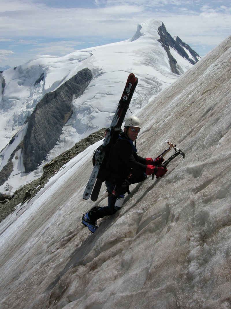
Dan surmounts a-swingin' for sweet sticks.

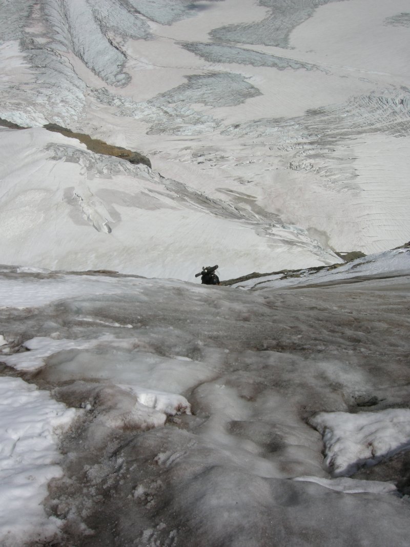
Ryan on mellower Alpine Ice above the crux of the Dome

Dan skis toward the Kain Face on a skintrack sans skins.

Ryan skis Kain Face while Dan waits his turn.

Dan with his first and best bergschrund boof of the day.

Ryan skis toward Resplendent.
Kain Face is like Baker's Park Headwall with the steeps lasting twice as long. Mount Robson is big and beautiful.
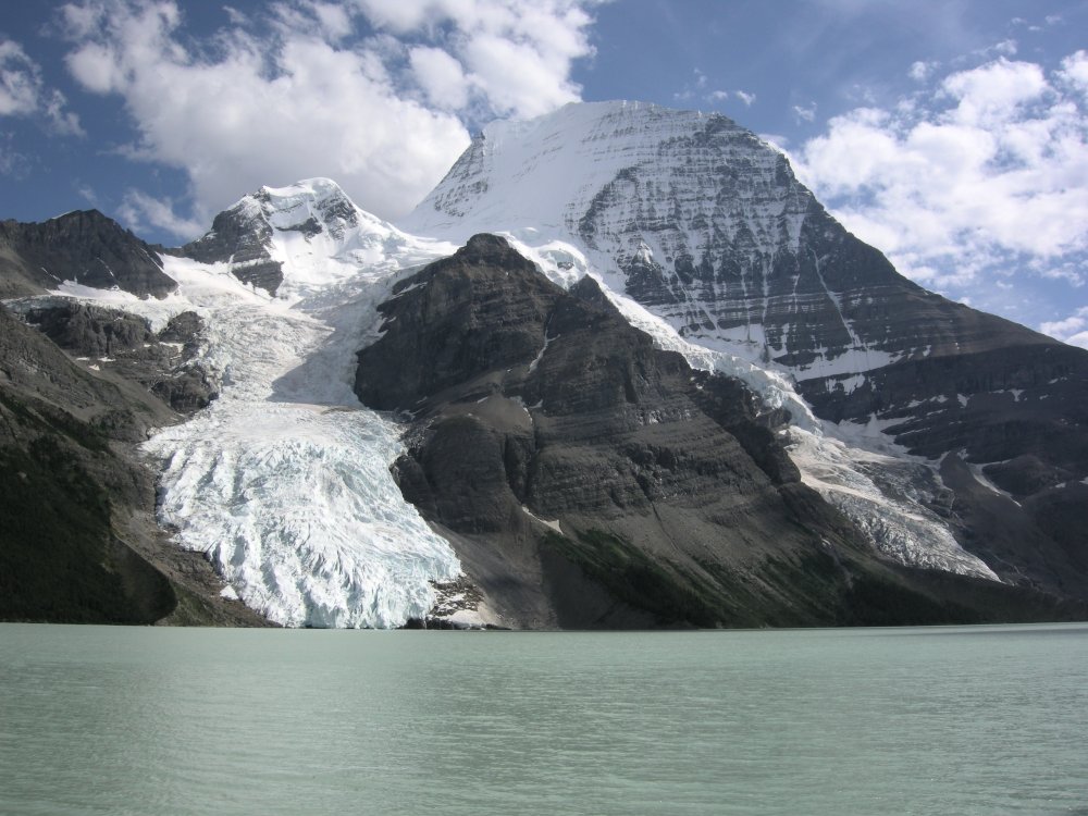
The North Face above Berg Lake and Berg (L) and Mist (R) Glaciers
Dan surmounts a-swingin' for sweet sticks.
Ryan on mellower Alpine Ice above the crux of the Dome
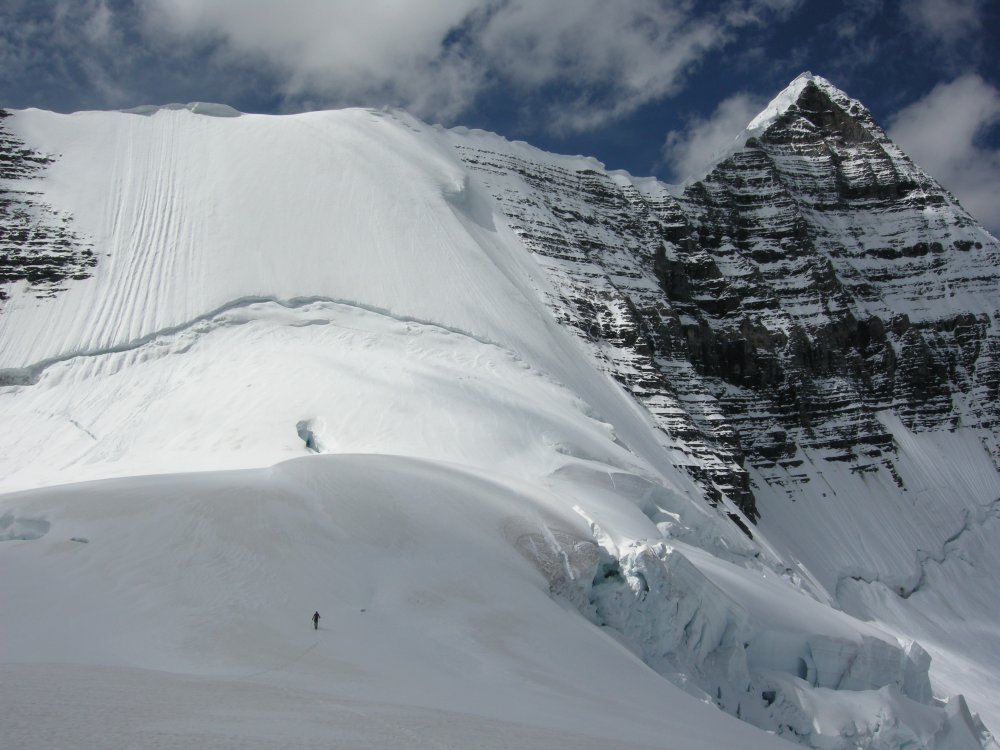
Dan skis toward the Kain Face on a skintrack sans skins.
Ryan skis Kain Face while Dan waits his turn.

Dan with his first and best bergschrund boof of the day.
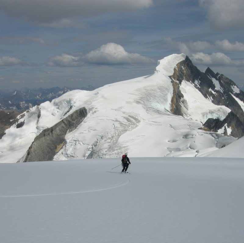
Ryan skis toward Resplendent.
Kain Face is like Baker's Park Headwall with the steeps lasting twice as long. Mount Robson is big and beautiful.
That first picture is SICK! Truly a rugged place. Nice work fellas.
Incredible...I remember watching a documentary of climbing Mt Robson about 23 years ago. It had it's share of challenges then, but you dudes skied it! The views must have been jaw dropping! Great accomplishment nice report!
Outstanding! I spent one of the best weeks of my life eating breakfast and dinner on the spot where the first photo was taken. Any of you bring a bike for the first bit up to Elkhorn or whatever that first camp is called?
Can't wait to get back there and Assiniboine.
Thanks for posting.
Can't wait to get back there and Assiniboine.
Thanks for posting.
You guys are animals! Looks like a gorgeous trip all around.
Congratulations on a great trip!
You guys had awesome conditions.
Here's a photo taken in late July 1990 when Joe Catellani and I climbed Robson by the Kain Face. The upper left part of the face had big icy-slushy runnels and the upper right had a lot of exposed ice.

Looks like you hit it just right. Nice job!
You guys had awesome conditions.
Here's a photo taken in late July 1990 when Joe Catellani and I climbed Robson by the Kain Face. The upper left part of the face had big icy-slushy runnels and the upper right had a lot of exposed ice.
Looks like you hit it just right. Nice job!
Wow, those are some very different conditions near the same time of year. I was hoping it would be good up there for several reasons, but mostly because various internet sources gave me the impression that it was a good snow year in the Canadian Rockies.
Photos from the last few decades make it look like the Kain Face has undergone several drastic changes.
Photos from the last few decades make it look like the Kain Face has undergone several drastic changes.
author=skykilo link=topic=7637.msg30577#msg30577 date=1185988626]Photos from the last few decades make it look like the Kain Face has undergone several drastic changes.
If you have a copy of "Climbing in North America" by Chris Jones, look at Ed Cooper's photo of Robson on p. 74. In this picture the center-right side of the face, which I presume is where you skied, is filled by a huge bulging serac. I imagine that Cooper's photo was taken in the 1960s or early 1970s. When I climbed the mountain in 1990, I think there was still a little bulge there, which is why the right side of the face was icier than the left.
Chic Scott's book "Powder Pioneers" seems ambivalent about whether the Kain Face has been skied before. He cites conflicting stories from Peter Chrzanowski on p. 212.
author=danhelmstadter link=topic=7637.msg30508#msg30508 date=1185813834]
Robson Provincial park is about 800 miles from seattle by the route we took.
It looks like its about 500 miles from Seattle... did you take a scenic route on purpose? ???
Nice write up Dan. Sorry about not posting sooner but my computer has been on the fritz. i'm with Phil, though,- not sure where the 800 miles came from? I think it took us about 12 hours to get there- and that's including customs and beer in vancouver, so it probably was closer to 500. Here are a few pics:
Sky at the Ranger station getting our first real view:


Hiking towards Robson Glacier, up the far off valley:


Dan approaching the Dome:

Dan and Sky kicking steps for me up the Kain:
[ ">
">
Sky taking first turns:

Our route from the bivy. red is ascent, blue is descent:

Sky at the Ranger station getting our first real view:

Hiking towards Robson Glacier, up the far off valley:

Dan approaching the Dome:

Dan and Sky kicking steps for me up the Kain:
[
 ">
">Sky taking first turns:

Our route from the bivy. red is ascent, blue is descent:

Cool route photo Ryan... it's the first one I've seen that makes your ascent make sense to me.
On your route Photo Ryan, is the kain face to the left of the North Face. I wasn't sure if that is the North face seen in the upper right of your route photo.
author=Jason_H. link=topic=7637.msg30588#msg30588 date=1186081815]
On your route Photo Ryan, is the kain face to the left of the North Face. I wasn't sure if that is the North face seen in the upper right of your route photo.
The Helmet-Robson col is out of sight beneath and in front of the summit. To get to the north face from the approach we took you'd have to cross the col and traverse to it, out of sight behind the summit and to the climber's right. The normal approach is to climb a buttress from Berg lake. We opted for the longer way up Robson glacier so we could see the standard descent route in case we didn't like what we found on the north face.
Reply to this TR
Please login first: