March 15, 2007, Granite Mountain (5,629)
3/15/07
WA Snoqualmie Pass
2740
4
[Text by WM Walker, Photos MW88888888 ps - none of the photos are of the big cornice drop in the text]
March 15, 2007
Day 43
Granite Mountain (el. 5,629) via Southeast Ridge / South Face, WA
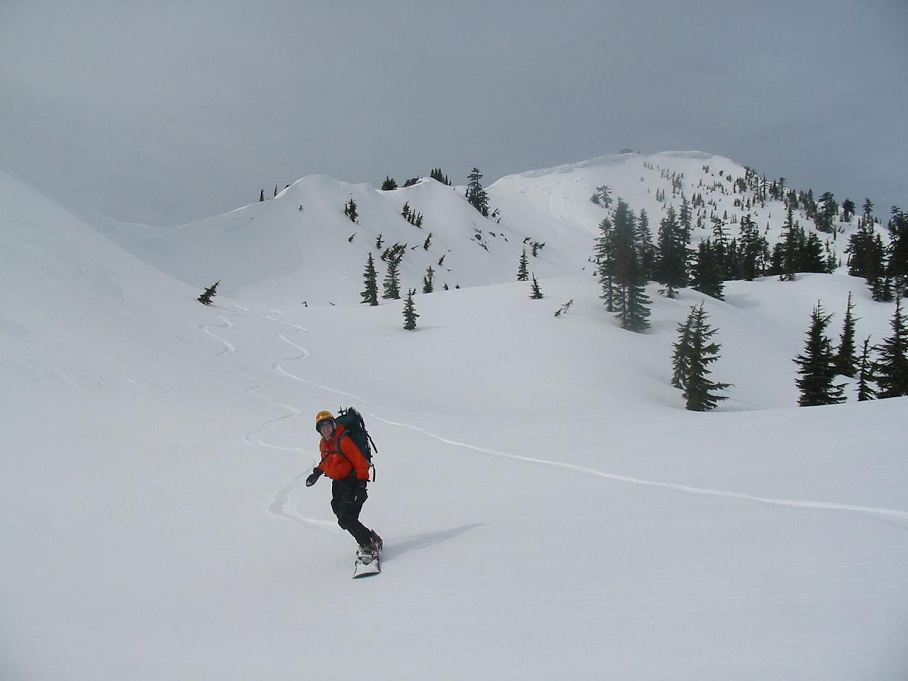
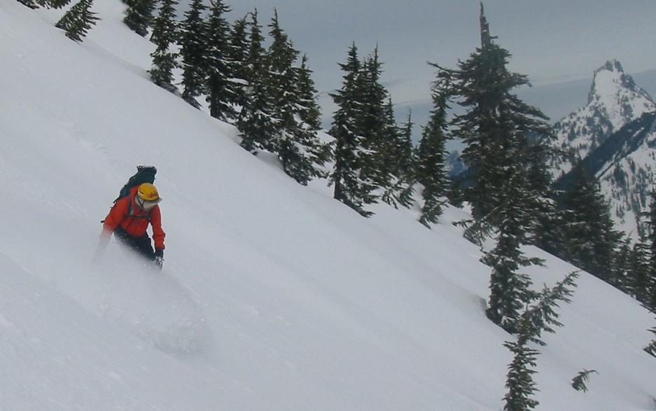
The south face of Granite was very fun to climb- positive axe and crampon
stances but it inspired less than optimistic snowboarding. The sun did not
cooperate and the old snow surface was an icy, hard concoction that we New
Englanders would call slightly edge-able boilerplate. Sure, itd be possible, and
even fun once you were below the over-the-cue-ball rollover off the summit.
But Mike and I took one look over the other side of the summit and spied the
SE Bowl beckoning for 500 below us.
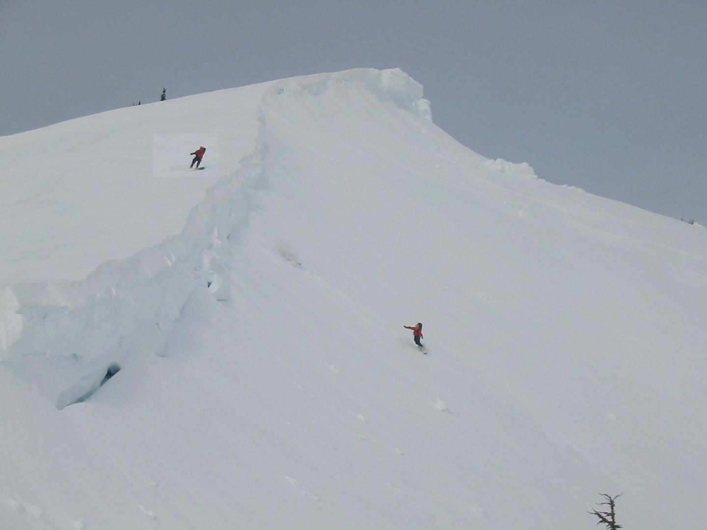
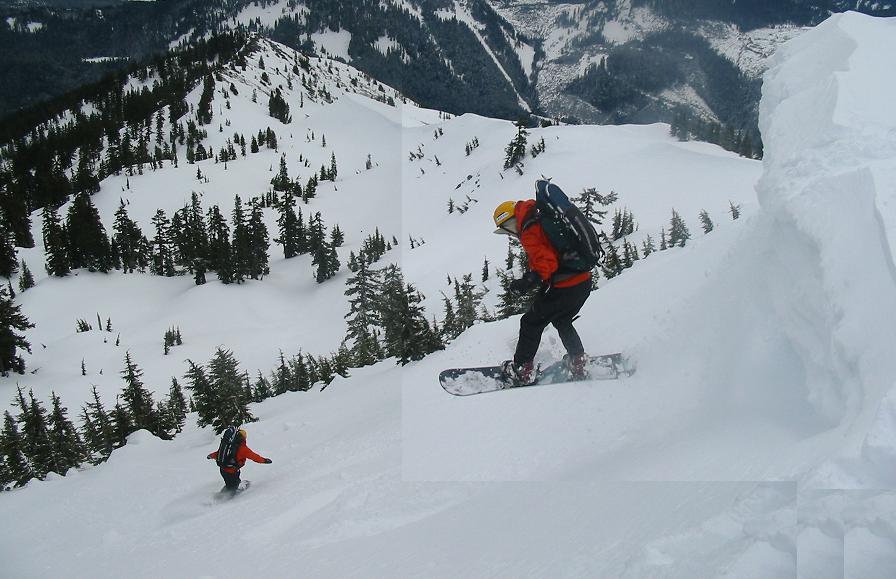
The summit of Granite had a large cornice forming the upper few hundred
vertical feet, sort of guarding the SE bowl below the SE ridge. It was pretty
impressive in that Cascade snow pack way- sometimes reaching heights of 30
feet or more.
I approached the edge on all fours, with the snowboard on the ground in front
of me. I knew from the climb up that in this area of the cornice the SE bowl is
a short 8 to 10 foot drop away- right in the midst of massive building size
overhangs. It was a pretty exciting moment crawling toward a strong white
horizontal line with the valley floor four thousand feet below.
I was heading for a faint flaw in the horizon line that seemed to match the
visual image in my head. I stopped crawling and leaned my head out and
peaked over the edge¦Bingo! The right spot! I backed up a few feet and
swung the snowboard in a small chop- cutting a 45 degree cut in the cornice
edge, then swinging again in the other direction- cutting a v-notch out of the
cornice. The resulting 18 inch snow block dropped away into the abyss below.
I peaked over the edge of the v-notch and watch the block bounce into the
bowl. The snow was 6-8 soft snow on a hardish base. The avy danger was
through its latest cycle and had returned to typical Cascade low dangers.
Strapping in- constant fun. Thats the thing. Constant Fun.
Over the edge and into the bowl¦
[Edited title - Charles]
March 15, 2007
Day 43
Granite Mountain (el. 5,629) via Southeast Ridge / South Face, WA
The south face of Granite was very fun to climb- positive axe and crampon
stances but it inspired less than optimistic snowboarding. The sun did not
cooperate and the old snow surface was an icy, hard concoction that we New
Englanders would call slightly edge-able boilerplate. Sure, itd be possible, and
even fun once you were below the over-the-cue-ball rollover off the summit.
But Mike and I took one look over the other side of the summit and spied the
SE Bowl beckoning for 500 below us.
The summit of Granite had a large cornice forming the upper few hundred
vertical feet, sort of guarding the SE bowl below the SE ridge. It was pretty
impressive in that Cascade snow pack way- sometimes reaching heights of 30
feet or more.
I approached the edge on all fours, with the snowboard on the ground in front
of me. I knew from the climb up that in this area of the cornice the SE bowl is
a short 8 to 10 foot drop away- right in the midst of massive building size
overhangs. It was a pretty exciting moment crawling toward a strong white
horizontal line with the valley floor four thousand feet below.
I was heading for a faint flaw in the horizon line that seemed to match the
visual image in my head. I stopped crawling and leaned my head out and
peaked over the edge¦Bingo! The right spot! I backed up a few feet and
swung the snowboard in a small chop- cutting a 45 degree cut in the cornice
edge, then swinging again in the other direction- cutting a v-notch out of the
cornice. The resulting 18 inch snow block dropped away into the abyss below.
I peaked over the edge of the v-notch and watch the block bounce into the
bowl. The snow was 6-8 soft snow on a hardish base. The avy danger was
through its latest cycle and had returned to typical Cascade low dangers.
Strapping in- constant fun. Thats the thing. Constant Fun.
Over the edge and into the bowl¦
[Edited title - Charles]
Is that the Granite offa I-90? Gotta get at that before meltdown.
Glad you had fun! I think I saw you on/near the summit while embroiled in the midst of my own misadventure on the SE flank of Low Mountain. Did you happen to take any photos from the summit looking toward Kaleetan that might've included Low? (If you happened to catch me, I'm probably only a little red or blue spot on the skyline of the SE ridge).
I had one excellent photo of the pow of the north bowl, [which I'll try and display, solely for snow reference you understand, Charles], which happens to show the dire snow on the Kaleetan summit chute.
Interesting choice on Low. My eyes wandered the lines off the mountain but obviuosly missed the climber. Who would be insane enough to slog into that peak? Uh, oh.
Also note about the photos in the post, as I think there is some confusion. They are photo shot job compilations, all of my brother. We're twins, but not Quadruplets.
I didn't truly wind up on Low by planned choice. I'd set out to do Kaleetan from Denny Creek, but got spooked by the premise of crossing the avy slopes above the first big falls on the creek. The slide paths on the W side of the creek had seen lots of activity with the heavy rain, but the slopes above the waterfalls hadn't yet slid (and would feed me to the waterfall if they did). So, for better or worse, I went straight up the avy debris into the forest/cliffband in hopes of traversing above the open slopes.
Careful inspection of the map shows me that I might have pulled it off, but I climbed too high too early to easily make the traverse. Several hours of climbing, traversing, downclimbing etc (with both tools and crampons on the crust ( low 40ish degree average slope, with short pitches up to ~55-60 degrees?... hard to tell)) put me onto the SE ridge of Low, which I ascended/traversed almost to the false summit before my exhausted body decided it wanted to go down. The S slopes of Low have a couple of interesting cliff bands/steep rolls (particularly close to the SE ridge near the bottom) that I had to work my way past (by traversing upvalley) and some interesting creek manufactured snow tunnels that I crossed with great trepidation. To add a little more worry to things, many of the minor rock outcroppings had ~10"ish glide cracks beneath them. When I finally got off the steep stuff, the warm wet sticky snow changed to rain.... By the end of the day I was extremely grateful that the snow was as stable as it was; most any day over the past couple months wouldn't have been so forgiving of my misadventure.
I can't recommend the route, though the crest of the SE ridge would've been fun had I not been tired, unhappy, and concerned about my prospects for descent. The day proved extremely educational for an almost uncountable number of reasons, and will stick in my memory for a long time to come, but it certainly wasn't super fun. If I were to head for the summit of Low in the future, I'd probably head for either its N or SSW ridges. The SSW ridge was my planned descent route, before I decided to bail off the SE ridge.
Fortunately, nobody saw fit to tow my car. I'd discussed access at the snowbermed end of Denny Creek Road with the Forest Service, and their response was somewhat ambiguous. The no parking signs at the end of the road are even more vague, as they don't make it clear exactly where parking becomes legal on the N side of the road.
Incidentally, the upper footbridge over Denny Creek is a little tricky to get onto as its E end abuts a short steep slope and the snow's well above the handrails. I was happy to have my second axe (but it wasn't requisite) for the short downclimb onto the bridge in the dark (I was aiming for Kaleetan, remember?....) .
My original personal TR (even more verbose, if that's possible)
Reply to this TR
Please login first: