2/17-18/07, Naches-Stampede 15 Infantry Traverse
2/17/07
WA Cascades East Slopes South
6799
12
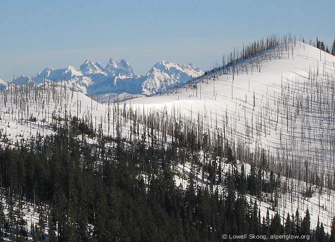
The Cascade Crest, Naches-Green River divide, between Pyramid Peak and Blowout Mountain. Chimney Rock rises in the distance.
This trip is part of a dream that has taken shape over 25 years. In 1982, I skied my first Cascade high route with Gary Brill and two others. I enjoyed it so much that in the following years, with that I led last winter. I dug out the maps and began studying the blank spots. I soon had a plan of attack, but I had serious doubts about whether I could find anyone to accompany me. My first priority was the segment from Naches Pass to Stampede Pass, a low, extensively roaded section that can only be skied in mid-winter.
Personal schedules and snow conditions aligned for a two-day attempt starting on Saturday, Feb 17. The trip would begin at the Pyramid Creek sno-park, about 10 miles east of Greenwater, off Highway 410. It would end at the Crystal Springs sno-park near I-90, east of Snoqualmie Pass. The ski distance between these two points is about 35 miles. Fortunately, my wife agreed to pick me up at Crystal Springs and drive me back to my car at Pyramid Creek, solving my logistical problems.
The Cascade Crest between Stampede Pass and Naches Pass has been skied at least once before. In February 1941, the 15th Infantry ski patrol, a forerunner of World War II's 10th Mountain Division, skied from Snoqualmie Pass to Greenwater. The patrol was led by Lt. John Woodward, who is shown in a photo in
Lowell on the SW slope of Blowout Mountain.
I left Seattle at 3 a.m. Saturday morning and was underway from Pyramid Creek by headlamp around 5 a.m. Due to our recent snow drought and heavy snowmobile traffic, Forest Service Road 70 near the sno-park had been transformed into an oily slab of ice. I walked a mile or two. Eventually the snow on the road improved and I skinned and skated to the foot of Pyramid Peak, reaching the top by 9 a.m.
The 7-mile section from Pyramid Peak to Blowout Mountain is the best part of the trip. You're right on the Cascade Crest, between the Naches and Green River drainages, and there's only one way to go. I don't know exactly where the 15th Infantry went on their route, but they must have followed this section. North of Blowout Mountain, I deliberately followed logging roads to simplify route finding. I expected the roads to be well traveled by snowmobiles, but was surprised to find no recent tracks for nearly 15 miles, from Pyramid Peak to Tacoma Pass. Without the good spring-like snow conditions I had, the trail breaking would have been exhausting.
From Tacoma Pass, I took a shortcut, following the Crystal Springs snowmobile trail system directly to The Mountaineers' Meany Lodge. A "purist" route would have dog-legged west along the Cascade Crest to Snowshoe Butte. But I didn't feel compelled to be a purist. My progress was fast enough that I could have reached Meany that evening, but since I was tired and hadn't made reservations at the Lodge, I camped at Cabin Creek Saturday night. I reached Meany in a couple hours on Sunday morning, after a night of rain and snow in my tent. The trip was intriguing and satisfying, with better conditions than I had hoped for, and my dream is one step closer to reality.
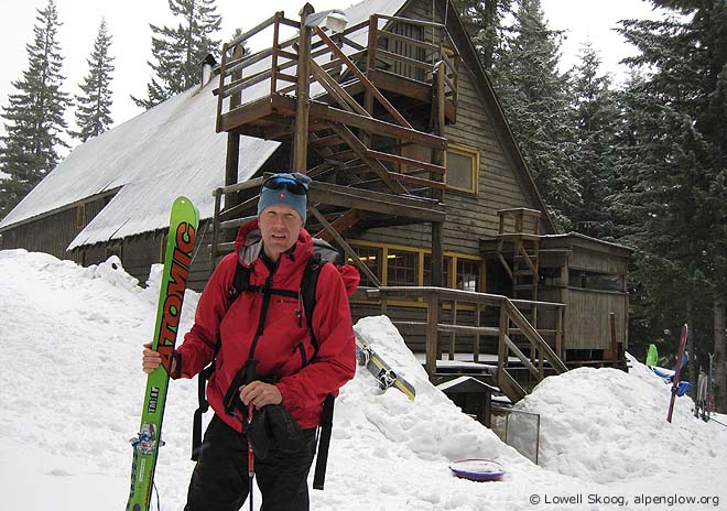
At the Mountaineers' Meany Lodge, near the end of the trip.
Partners wanted! One or two friends have expressed interest in joining me for portions of this odyssey. But I could use more potential partners. If you're a strong skier who's interested in seeing seldom-skied sections of the Cascades, send me a note!
Your story reminds me of when Ben was alive. At the time we talked about traversing Washington North to south and how we would do it, but since he's gone I lost the vision along with the time. Like you maybe I should just patch it together. Maybe one day I'll get 'er done.
BTW, Fine work on this adventure! Send me an e-mail when you need someone. If I have the time, I'll go.
BTW, Fine work on this adventure! Send me an e-mail when you need someone. If I have the time, I'll go.
Very cool idea Lowell. Keep going!!
Seems like the chunk between Snoqualmie and Steven' Passes should be scenic too.
It'd be great to join you for a stretch, but I'm in Germany until next Fall... maybe then.
As always, your combo of narrative, photos and history make for outstading vicarious living.
Seems like the chunk between Snoqualmie and Steven' Passes should be scenic too.
It'd be great to join you for a stretch, but I'm in Germany until next Fall... maybe then.
As always, your combo of narrative, photos and history make for outstading vicarious living.
author=JibberD link=topic=6317.msg25995#msg25995 date=1172003215]
Very cool idea Lowell. Keep going!!
Here's what I've done so far and what remains to be done. The segments marked "soon" are the ones that I still need to do. The routes are listed north to south, but I've done the segments in whatever order and direction is most efficient.
1990 - Mt Baker, Watson Traverse (Kulshan Cabin to Baker ski area)
2004 - Mt Shuksan, Nooksack Traverse (Baker ski area to Hannegan Pass)
1985 - Picket Range Traverse (Hannegan Pass to Diablo)
1983 - Isolation Traverse (Diablo to Cascade River)
1982 - Ptarmigan Traverse, standard (Cascade River to Dome Peak)
2000 - Ptarmigan Traverse, extended finish (Dome Peak to Image Lake)
1989 - Suiattle High Route (Image Lake to Glacier Peak)
soon - Glacier Peak from White Pass (via North Fork Sauk River)
soon - White Pass to Stevens Pass
soon - Stevens Pass to Cle Elum River
2002 - Alpine Lakes Traverse (Cle Elum River to Snoqualmie Pass)
2001 - Patrol Race Route (Snoqualmie Pass to Stampede Pass)
2007 - 15th Infantry Traverse (Stampede Pass to Naches Pass)
soon - Naches Pass to Crystal Mountain
1991 - Crystal Mountain to Cayuse Pass
2001 - Cayuse Pass to Paradise
2003 - Mt Rainier, Tahoma Traverse (Paradise to Tahoma Glacier via summit)
I enjoyed the tr, and if my kid will let me, I would like to go along on a tour of your remaining sections - I usually can swing a long day, and occaisionally an overnighter.
But my really question is about those boots, my eyes can't make out if they are dynafits, but it looks like it, how light are they, and do they ski OK or are they reserved for long roads trips like this one?
But my really question is about those boots, my eyes can't make out if they are dynafits, but it looks like it, how light are they, and do they ski OK or are they reserved for long roads trips like this one?
I'd be interested in the glacier peak to white pass section. Love glacier peak!!!
author=RonL link=topic=6317.msg26004#msg26004 date=1172008867">But my really question is about those boots, my eyes can't make out if they are dynafits, but it looks like it, how light are they, and do they ski OK or are they reserved for long roads trips like this one?
There was a lively discussion of these boots a couple of years ago. I call them my "ultimate alpine TOURING boots". For me, they ski well enough for doing high routes. For steep descents or yo-yoing, I use standard Dynafit TLT4 boots.
ah, thanks, so they are modified MLT4s; doesn't look like those are available anymore and from the discussion it looks like what is need is some kind of locking bellows - flexes in walk mode and not in downhill, perhaps at boot makers of the future will come up with something.
I'd be pleased to join you for any of the remaining tours.
Lowell - that's a great project. I'm about to retire and would love to join you on some of those sections. Skip Edmonds
Skip, great to hear from you. Welcome to TAY!
I've harvested the e-mail address from your profile and have added you to my pool of contacts.
BTW, if anybody tried sending me an e-mail during the past few days, sorry for my lack of response. I'm in the middle of switching e-mail providers, and I'm not getting any messages right now . :-[ >:( ??? :'(
Ah ha.... I may have been one who got lost in translation as you switched your email provider. Anyhow, I would be utterly delighted to participate in the adventure! Especially the White pass/ Glacier traverse. Let me know.
The e-mail I sent last week bounced back. PM sent.
Reply to this TR
Please login first: