Aug15, 06: St Mary's Glacier, CO
8/15/06
US elsewhere
4278
4
This is the time of year that I envy you PNW skiers! We may have the dry light powder in midwinter, but when it comes to summer turns, the pictures do not lie. Compared with the perfect corn I skied on Rainier in July, my August TAY day was.... well, let's just say that I got in 300- 400 vertical feet on what could generously be described as snow, but more accurately as densely compacted suncups covered in a barely perceptible frosting of corn, garnished with a generous dusting of dirt. Compared with the pictures posted on the other August TR's, I seem to have been rather shortchanged in the fun-on-the-way-down department; this trip was a lot more fun on the way up. Nevertheless, it is month 22 for me, and if we are lucky enough to get some early season snow in September (a pretty good bet around here) I will be on the way to my 3rd TAY season.
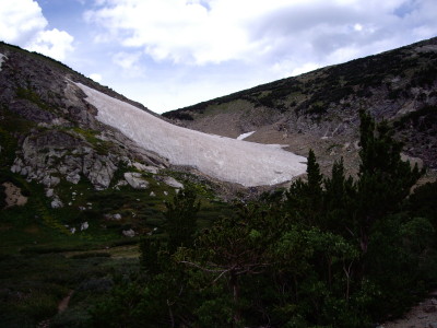
St. Mary's Glacier is located about 45-60 minutes west of Denver, just past Idaho Springs and 15-20 minutes off I70, at about 10,800ft. It is about a 3/4 mile easy hike in from the road to the foot of the glacier.

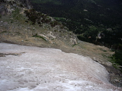
View from the top. The two little red dots on the rocks are some hikers waiting to see if I was going to make a fool of myself on the way down (it wasn't pretty skiing, but no yard sale either. The suncups were rock hard and unforgiving, but that's late summer skiing in Colorado.

St. Mary's Glacier is located about 45-60 minutes west of Denver, just past Idaho Springs and 15-20 minutes off I70, at about 10,800ft. It is about a 3/4 mile easy hike in from the road to the foot of the glacier.
View from the top. The two little red dots on the rocks are some hikers waiting to see if I was going to make a fool of myself on the way down (it wasn't pretty skiing, but no yard sale either. The suncups were rock hard and unforgiving, but that's late summer skiing in Colorado.
You have earned my admiration!
That looks like a lot of hard work for August turns.
Makes me realize how lucky we have it in the PNW. :D
That looks like a lot of hard work for August turns.
Makes me realize how lucky we have it in the PNW. :D
You call that thing a glacier?
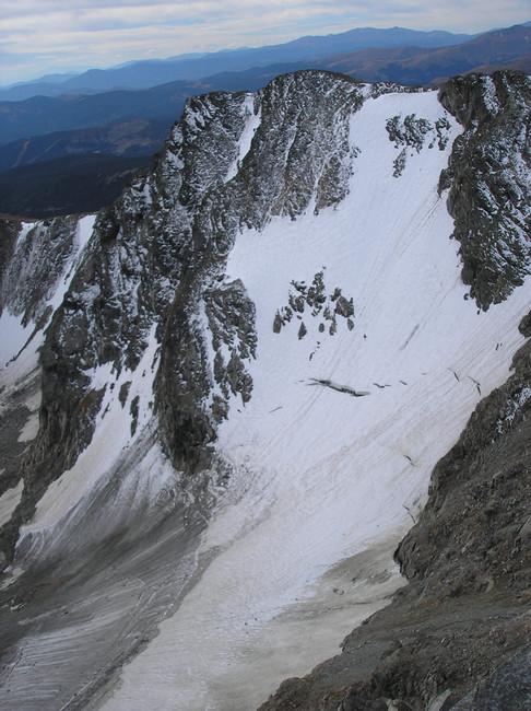
check out tyndall or ptarmagain glaciers near flattop mtn in rocky mountain national park, they should be in better shape than st marys, thier also a little steeper,, i bet the arapahoe glacier still is in good shape,, i skiied it last year mid september,, got about 1300v in on primo corn at a nice pitch, it is "illegal" cause it is the headwaters for the boulder watershed,, you can avoid the authorities if you scramble up to the saddle to the south about a qwuarter mile to the east of the glacier to get back to the arapahoe mt trail. bring your crampons ,youll probally need them at the very end of the glacier where all the snow has melted off exposeing ice,, also bring helmut cause the glacial ice at the bottom sheds alot of rocks which pick up speed surpriseingly quickly,, you can scope the route out from 1-25/ east boulder/ or peak to peak highway,, access it by the fourth of july trailhead off the eldora road.,, its a litte further back than st marys but definatly worth it,, i pulled this pic off summitpost.org,, its not as steep as it looks,, only about 45 at very top but probally not even,, this pic is probally from early winter/late fall
author=Pandora link=topic=5229.msg22046#msg22046 date=1156031398]
You call that thing a glacier?
Yeah, I know what you mean. But this is CO, not the NW, and they call it one here. Actually, it extends quite a bit farther up on climbers right going out towards one route of access to James Peak(out of view of the picture, beginning about a third of the way up the pitch in the picture), but that was in much worse shape (because of the aspect it gets suncupped earlier and worse) and is much more moderately pitched- probably only about 15-20 degrees.
Dan- thanks for the beta- I will definitely check out those places.
Reply to this TR
Please login first: