June 10, 2006; The Hamma Hamma (SE Olympic Mtns)
6/15/06
WA Olympics
3915
6
Mt. Skokomish (Hamma Hamma Valley):
I still have never found out for sure what the native name Hamma Hamma translates to in English, though have come across at least one unverified anecdotal reference roughly translating the phrase as Stinky Stinky. That unverified translation fits well for describing ones scent after tackling this rigorous route.
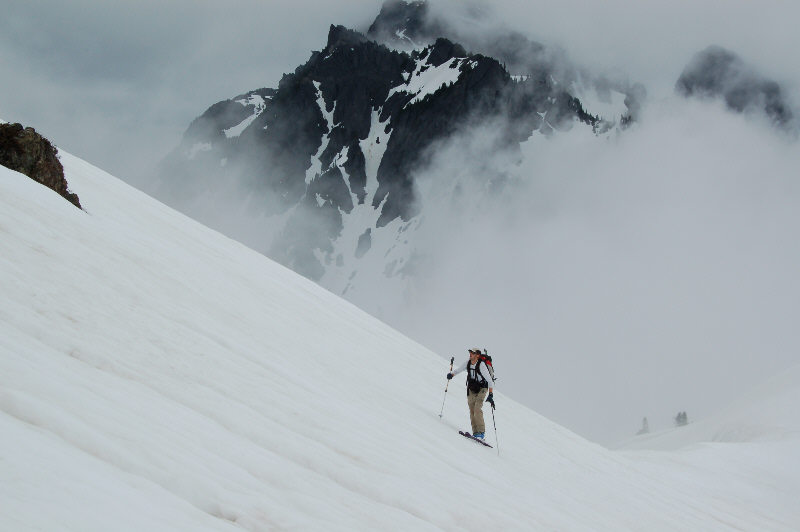
After two previous trips to this area of the Hamma Hamma valley without skis, I figured it was high time to haul skis up here. Skip was also eager to scope out Mount Skokomish on skis via the Lake of the Angels basin, though this alpine area was well guarded by a steep snow-less approach beginning at around 1,500-ft elev. and climbing ~3,000 vertical ft in less than 2 miles to reach snowline.
All in all, we were quite happy with our ski-to-hike ratio of ~40% : ~2,000 vert ft skied after ~5,000+ vertical feet of hiking/trudging/crawling/skinning/climbing/scampering up to the top of ~6,400+ ft high Mount Skokomish.
We donned skis at snowline (~4,300-ft elev) on a southeasterly aspect, shortly after (elev. ~4,900ft) where the snowpack was still mostly over ~4-to-5 feet thick. The clouds parted nicely upon our arrival at the basin allowing us to scope out a few additional ski options. We opted to continue our initial plan of climbing up Mt. Skokomish, ascending through mostly gentle terrain in the basin to reach a high pass.
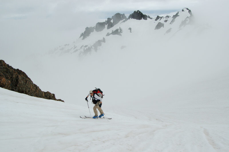
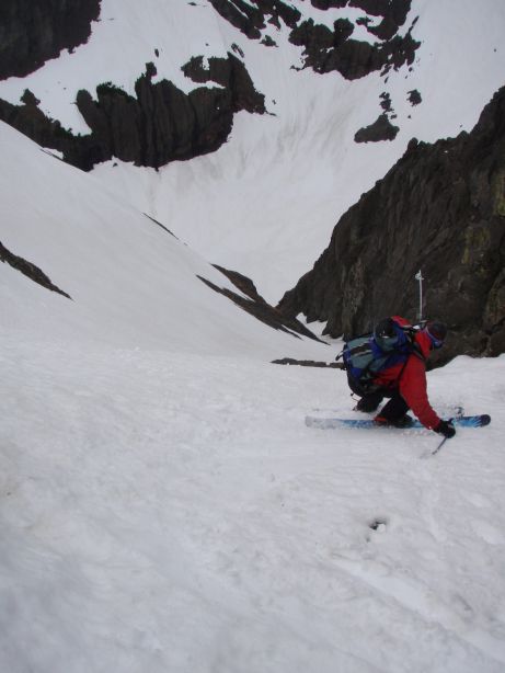
Once beyond the ~5,800-ft pass, the final portion of the ascent route led to . Traversing higher than our ascent route to avoid skiing down a slope with a fairly exposed runout (cliff), we found a much nicer line with good corn turns and a good runout (the upper ~1-2 inches had softened enough by this time to sluff in places, but the snow beneath was still quite firm). The white-out gave way to visibility once we descended below the lake basin where we enjoyed a ~200 vert ft steep section of excellent corn turns. The rest of the ski was mostly traversing through the meadows with some occasional turns. We couldnt wait to strap the skis back onto the packs for the fun knee-jarring hike down, including crawling back through the cliffbands on the trail. After about 9-1/2 hours out, we were relieved to return to sea level for apres-ski BBQ, & beer :)
Rest of the trip photos are posted here
I still have never found out for sure what the native name Hamma Hamma translates to in English, though have come across at least one unverified anecdotal reference roughly translating the phrase as Stinky Stinky. That unverified translation fits well for describing ones scent after tackling this rigorous route.
After two previous trips to this area of the Hamma Hamma valley without skis, I figured it was high time to haul skis up here. Skip was also eager to scope out Mount Skokomish on skis via the Lake of the Angels basin, though this alpine area was well guarded by a steep snow-less approach beginning at around 1,500-ft elev. and climbing ~3,000 vertical ft in less than 2 miles to reach snowline.
All in all, we were quite happy with our ski-to-hike ratio of ~40% : ~2,000 vert ft skied after ~5,000+ vertical feet of hiking/trudging/crawling/skinning/climbing/scampering up to the top of ~6,400+ ft high Mount Skokomish.
We donned skis at snowline (~4,300-ft elev) on a southeasterly aspect, shortly after (elev. ~4,900ft) where the snowpack was still mostly over ~4-to-5 feet thick. The clouds parted nicely upon our arrival at the basin allowing us to scope out a few additional ski options. We opted to continue our initial plan of climbing up Mt. Skokomish, ascending through mostly gentle terrain in the basin to reach a high pass.
Once beyond the ~5,800-ft pass, the final portion of the ascent route led to . Traversing higher than our ascent route to avoid skiing down a slope with a fairly exposed runout (cliff), we found a much nicer line with good corn turns and a good runout (the upper ~1-2 inches had softened enough by this time to sluff in places, but the snow beneath was still quite firm). The white-out gave way to visibility once we descended below the lake basin where we enjoyed a ~200 vert ft steep section of excellent corn turns. The rest of the ski was mostly traversing through the meadows with some occasional turns. We couldnt wait to strap the skis back onto the packs for the fun knee-jarring hike down, including crawling back through the cliffbands on the trail. After about 9-1/2 hours out, we were relieved to return to sea level for apres-ski BBQ, & beer :)
Rest of the trip photos are posted here
author=cascadesfreak link=topic=4917.msg20729#msg20729 date=1150148714]
We couldn’t wait to strap the skis back onto the packs for the fun knee-jarring hike down
whoa, i bet that was your favorite part!! ;)
sounds like you guys had some quality burly time together. hot pics too...way to get out there where no one ever skis!! :D
Looks like a killer trip, Cass. I climbed Mt. Stone about seven years ago, and we camped at Lake of the Angels.... your pics bring back memories, even tho there wasn't any snow there at the time!!
Oh, and if you like steep approach hikes in the Olympics... I'm sure there's some sick skiing on the chutes of Mt. Constance right now!! ..... (ever hiked that trail to Lake Constance? ;D )
author=cascadesfreak link=topic=4917.msg20729#msg20729 date=1150148714]
We couldn’t wait to strap the skis back onto the packs for the fun knee-jarring hike down, including crawling back through the cliffbands on the “trail”.
Oh, and if you like steep approach hikes in the Olympics... I'm sure there's some sick skiing on the chutes of Mt. Constance right now!! ..... (ever hiked that trail to Lake Constance? ;D )
That 'trail' was my first ever hike in the Olympics -- Nice work making it up there despite our fickle weather!
Chute 1a on Constance was in good shape on 5-21. Stone and Skokomish were in pretty fun conditions back in February as well...kinda icy but it wasnt too bad. I like skiing in the Olympics ;D
author=Double_E link=topic=4917.msg20752#msg20752 date=1150172504] (ever hiked that trail to Lake Constance? ;D )The Lake Constance area has been on the radar for quite awhile too, and have yet to hike that trail ;). The last I heard the Dosewallips Road was still washed-out ~3.5 miles from the Lake Constance Trailhead...
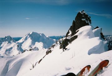
AJScott- Nice winter pic from Mt. Stone. We were considering skiing a line on Stone last weekend on the way out from Skokomish, but changed our minds once the white-out rolled-in.
Nice job guys. Love to see those reports from Cin's part of the world. Guess I'll be heading that way on Friday since I wasn't invited to your BBQ ??? Sorry, couldn't help myself.
RTG HK
RTG HK
Reply to this TR
Please login first: