June 10, 2006, Mt. Cheam
6/10/06
3095
2
International travel beckoned me again this weekend, when telemon offered to guide me up Mt. Cheam along the Chilliwack River just north of the border. A brief visit to Foley Creek logging camp and its Russian helicopter preceded our drive up the proper road to 4360' on Mt. Cheam where we were stopped by continuous snow.
We found nice spring corn conditions with no suncups on steeper slopes from there to within 500' of the summit of Mt. Cheam (pronounced "shim") This south facing area appears to be a sledders winter playground, and it provides a nice two and a half hour summer hike for those whose vehicle can reach the trailhead. The views to the Washington North Cascades should be superb, but on this day were obscured by cloud, as were the views north to the Fraser river.
We found nice spring corn conditions with no suncups on steeper slopes from there to within 500' of the summit of Mt. Cheam (pronounced "shim") This south facing area appears to be a sledders winter playground, and it provides a nice two and a half hour summer hike for those whose vehicle can reach the trailhead. The views to the Washington North Cascades should be superb, but on this day were obscured by cloud, as were the views north to the Fraser river.
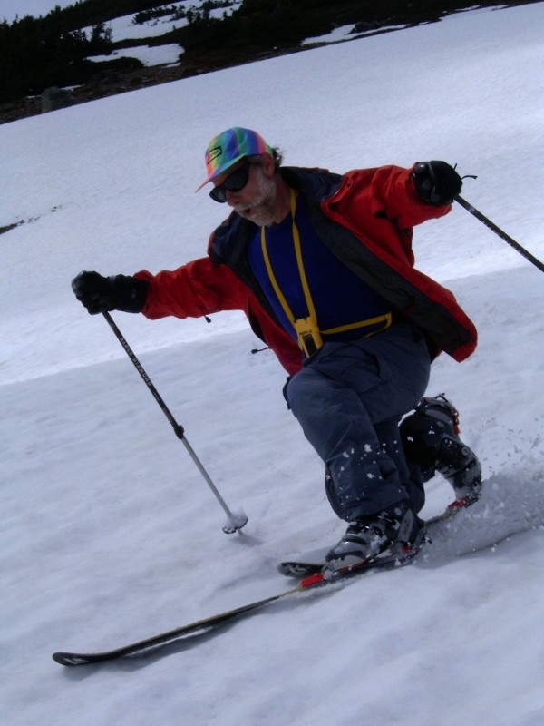
We had a massive thunder/lightening/hail storm pass through this afternoon, knocking out our power and allowing Silas to get a report in first. Mt.Cheam is a 6,930' prominent and distinctive peak in British Columbia's eastern Fraser Valley. On a clear day it is visible from Vancouver, but it is at its most impressive when viewed at near sea level from the Trans Canada Highway east of Chilliwack. I had climbed it several times a decade ago, but never on skis. The difficulty is the floating window of opportunity. If you wait for the access road to melt out, the snow on the very skiable south-facing aspects of Cheam will have also deteriorated.
It was my first trip with Silas (a successful TAY hookup). Rounding up our party was Nick D (not the TAY one, but the TTPS one). Neither of these guys had been on Cheam, but they were enthusiastic. The trip requires a high clearance vehicle once you start climbing from Chilliwack Lake Road. The Chipmuck Creek Forest Forest Service Road takes you to the summer hiking parking lot at 4,860', but our vehicular progress was stymied at about 4,340', approximately a mile from the Trail Head.
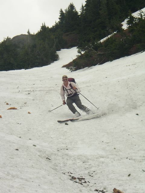
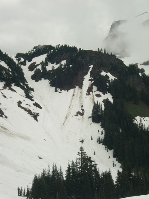
Our problem wasn't the extra skiing distance, but the variable visibility. We couldn't see our destination and somehow got ourselves into a drainage and ridgeline west of our target. After a drop of 500' on a NE facing slope, we located the summer trail route through the clouds. Unfortunately it appeared to be lacking sufficient snow, so we went up the 800' gully shown above.This brought us to a flattish saddle, about 1,000' below the summit. In the sunshine we could see the sheer face of Lady Peak next door, but the International Border-lining peaks to the south were obscured with clouds.
With deadlines facing us, we decided to abandon the summit and only climb to the top of the 750' snowfield above us. As Silas said, we had a great run down this slope and after picking up our packs in the saddle, an interesting descent in the rubble strewn gully. We had some difficulty finding the correct trail back to the road as we were experiencing near whiteout conditions. Once we located the trail and the parking lot that we should have passed on the way up, we were able to ski pretty well all the way back to the Explorer. The showers that had been forcast with a 60% probability began as we were loading our gear. A relatively simple ski summit attempt that had turned into an adventurous tour was safely over.
(Edit by moderator to remove excess photos.)
It was my first trip with Silas (a successful TAY hookup). Rounding up our party was Nick D (not the TAY one, but the TTPS one). Neither of these guys had been on Cheam, but they were enthusiastic. The trip requires a high clearance vehicle once you start climbing from Chilliwack Lake Road. The Chipmuck Creek Forest Forest Service Road takes you to the summer hiking parking lot at 4,860', but our vehicular progress was stymied at about 4,340', approximately a mile from the Trail Head.
Our problem wasn't the extra skiing distance, but the variable visibility. We couldn't see our destination and somehow got ourselves into a drainage and ridgeline west of our target. After a drop of 500' on a NE facing slope, we located the summer trail route through the clouds. Unfortunately it appeared to be lacking sufficient snow, so we went up the 800' gully shown above.This brought us to a flattish saddle, about 1,000' below the summit. In the sunshine we could see the sheer face of Lady Peak next door, but the International Border-lining peaks to the south were obscured with clouds.
With deadlines facing us, we decided to abandon the summit and only climb to the top of the 750' snowfield above us. As Silas said, we had a great run down this slope and after picking up our packs in the saddle, an interesting descent in the rubble strewn gully. We had some difficulty finding the correct trail back to the road as we were experiencing near whiteout conditions. Once we located the trail and the parking lot that we should have passed on the way up, we were able to ski pretty well all the way back to the Explorer. The showers that had been forcast with a 60% probability began as we were loading our gear. A relatively simple ski summit attempt that had turned into an adventurous tour was safely over.
(Edit by moderator to remove excess photos.)
For those who are interested in more pictures of our Mt.Cheam tour, check out : http://gallery.telemen.ca/main.php?g2_itemId=1764
Enjoy, Bob
Enjoy, Bob
Reply to this TR
Please login first: