April 30, 2006, Eldorado
4/30/06
WA Cascades West Slopes North (Mt Baker)
2259
1
My buddy Paul from Vancouver and I decided to head up El Dorado today. The plan originally called for doing it yesterday but we saw the light, or better, the rain and decided to reschedule for today. Proved to be a wise choice. After bedding down at the trail head (the road is open to the parking lot but the gate to get up to Cascade Pass trailhead remains closed), we were on our way just before 6AM. The Cascade River crossing proved to be a bit trickier than the guidebooks let on (practically took a class 3 move to get onto the first big log). With that out of the way, it was up the steep approach. We hit patchy snow around 3700 feet and more consistent coverage right at the first talus field. The field is pretty much covered except in a few spots but it's not deep. Fortunately, in the morning, it was firm enough to move through it with minimal difficulty. Once it softens up later in the day it is post-hole central with high potential for injury. Thick clouds the entire way up before the first sun breaks above the talus field.
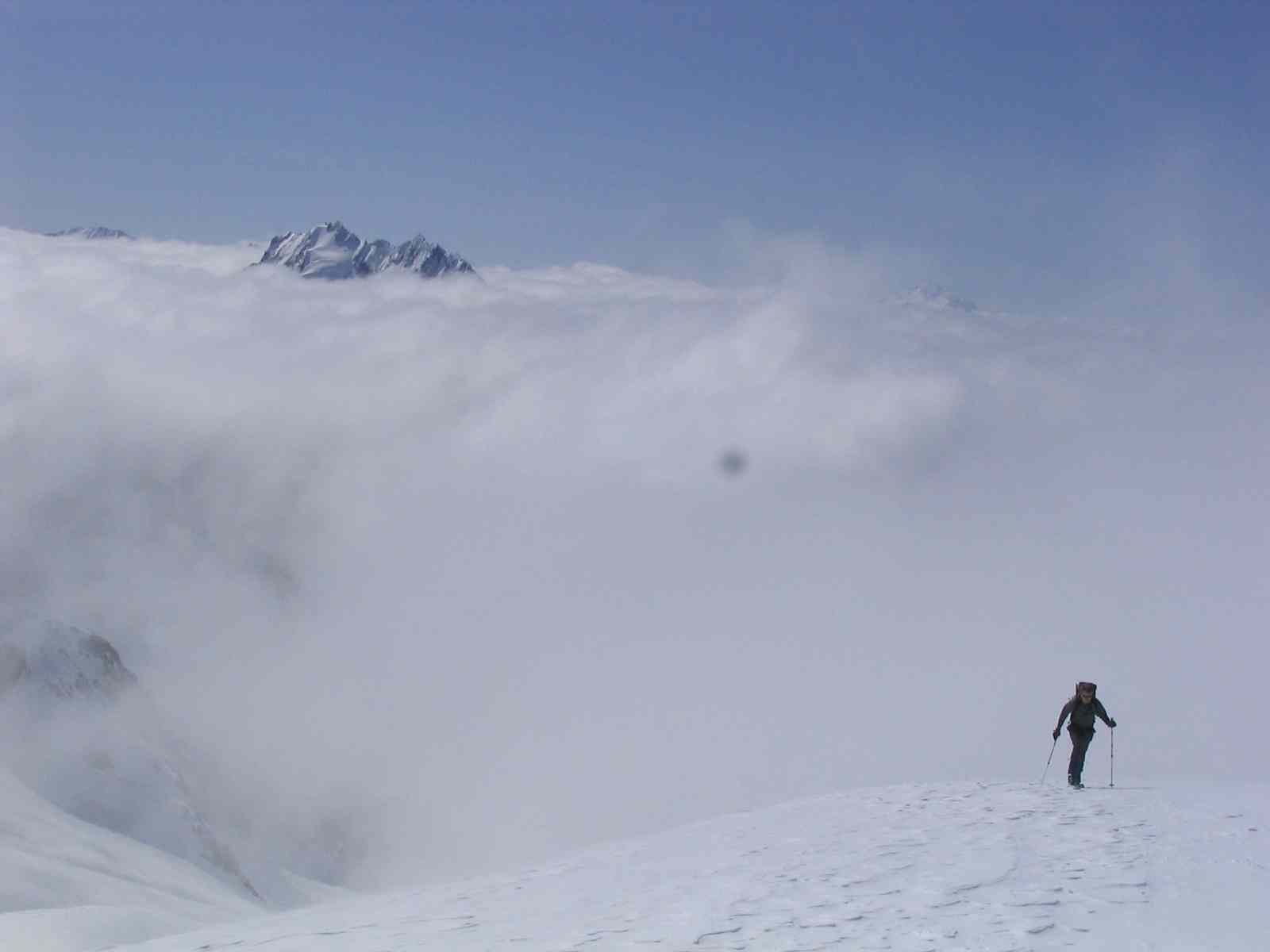
Above the talus field we found nice, firm steps that had been put in by various groups that had travelled in the day before. We eventually put our skis on at around 5500 feet and found easy skinning up to the ridge separating the El Dorado creek and Roush Creek drainages. After dropping over the crest onto the El Dorado glacier, it was even better. A group of ATers who had camped on the crest the previous night put in a nice track and the skinning was super easy. Scattered evidence of avalanche activity which all seemed to be sloughs and point releases. No slabs. The whole way up to the Inspiration Glacier we were in and out of the clouds but once we crested on the glacier we were above it all and had crystal clear skies with great views of Forbidden and all the other big peaks in that area. It was easy skinning across the glacier and over to the summit ridge. Once on the ridge, we found quite variable snow with soft stuff in spots and firm ice in others. We took off the skis for a bit but eventually put them back on and skinned to within about 10 meters of the top. We booted up the knife edge ridge and summitted 6 hours and 15 minutes after leaving the cars. Spectacular views and... we had it all to ourselves as the three previous groups had all headed down.
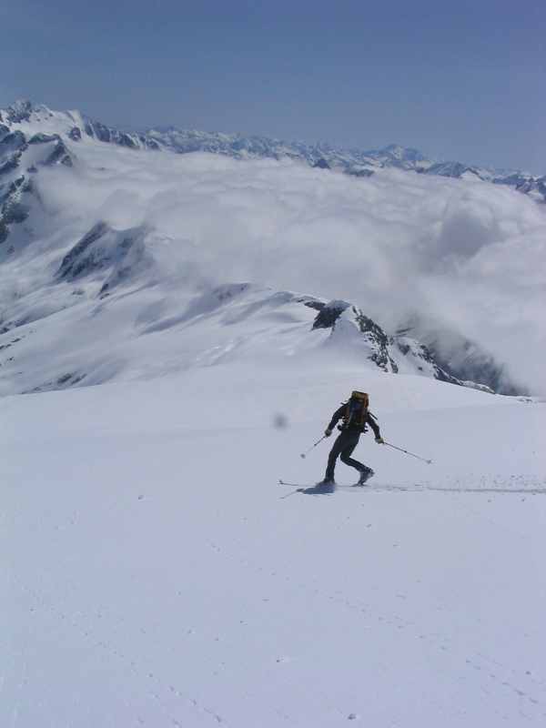
After lunch, it was time to put the skis on and head down. The ridge down to Inspiration Glacier made for good turning but very variable snow. Firm and icy in spots, corn in places and soft windpack in others. I managed to find the one problem crevasse on the route on my way down as the snow bridge broke way under me as I was making a turn leading to a nice face plant. That's at about 8,400 ft o n the south side of the ridge. Other than that, there were no open crevasses or any hints of them on the entire route. It was fast travelling down from there. The snow on the El Dorado glacier was great until about 6,400 feet where it turned to mush. From there, over the crest and down the drainage for El Dorado creek, the snow was just plain terrible. It had rained the day before and the snow was wet and saturated. No turns to be had unless you count the myriad of kick turns from the endless traversing and survival skiing. We did find one brief patch of great snow just above the talus field. By the time we got down to the talus field, the snow was way to soft to consider taking off the skis. Big post-hole potential. So... we kept them on and did yet more traverses, kick turns and lots of side slipping until we got to the bottom of the talus field, put the skis on our packs and headed down
Time from car to summit: 6 hours 15 minutes
Time down from summit to car: 3 hours 45 minutes
Gear: Axes, shovels, beacons, crampons, rope (never used), harness (never used)
Above the talus field we found nice, firm steps that had been put in by various groups that had travelled in the day before. We eventually put our skis on at around 5500 feet and found easy skinning up to the ridge separating the El Dorado creek and Roush Creek drainages. After dropping over the crest onto the El Dorado glacier, it was even better. A group of ATers who had camped on the crest the previous night put in a nice track and the skinning was super easy. Scattered evidence of avalanche activity which all seemed to be sloughs and point releases. No slabs. The whole way up to the Inspiration Glacier we were in and out of the clouds but once we crested on the glacier we were above it all and had crystal clear skies with great views of Forbidden and all the other big peaks in that area. It was easy skinning across the glacier and over to the summit ridge. Once on the ridge, we found quite variable snow with soft stuff in spots and firm ice in others. We took off the skis for a bit but eventually put them back on and skinned to within about 10 meters of the top. We booted up the knife edge ridge and summitted 6 hours and 15 minutes after leaving the cars. Spectacular views and... we had it all to ourselves as the three previous groups had all headed down.
After lunch, it was time to put the skis on and head down. The ridge down to Inspiration Glacier made for good turning but very variable snow. Firm and icy in spots, corn in places and soft windpack in others. I managed to find the one problem crevasse on the route on my way down as the snow bridge broke way under me as I was making a turn leading to a nice face plant. That's at about 8,400 ft o n the south side of the ridge. Other than that, there were no open crevasses or any hints of them on the entire route. It was fast travelling down from there. The snow on the El Dorado glacier was great until about 6,400 feet where it turned to mush. From there, over the crest and down the drainage for El Dorado creek, the snow was just plain terrible. It had rained the day before and the snow was wet and saturated. No turns to be had unless you count the myriad of kick turns from the endless traversing and survival skiing. We did find one brief patch of great snow just above the talus field. By the time we got down to the talus field, the snow was way to soft to consider taking off the skis. Big post-hole potential. So... we kept them on and did yet more traverses, kick turns and lots of side slipping until we got to the bottom of the talus field, put the skis on our packs and headed down
Time from car to summit: 6 hours 15 minutes
Time down from summit to car: 3 hours 45 minutes
Gear: Axes, shovels, beacons, crampons, rope (never used), harness (never used)

Very nice report and great photography.
Yes, that initial log crossing is a doosey. We made an attempt at Eldorado just under a year ago and were turned back by rain and super slick conditions in the talus field, etc. But that river crossing was the freakiest part for me. Also that trip was my first introduction to the concept of the "climbers path." More like what's left behind after an old growth fir log travels the path of least resistence down a 40 degree slope...or perhaps even less defined than that.
Glad to hear the crevasse you located didn't make a meal of you.
Reply to this TR
Please login first: