April 29, 2006, Mailbox Peak
4/29/06
4069
3
We decided it was time to revive the "Joy-O-Meter" (always a good for endurance training) and seek out a steep hike up (~4,000 vert. ft in under 3 miles) to link some snow patch turns for a grand total of 700 vertical feet skied (700 vertical ft skied / 4,000 vertical feet hiked-up = 17.5%) Not too bad considering that for just an extra half-hour of driving up to Snoq pass, the Joy-O-Meter wouldve been 100% :)
I managed to con Allyson into carrying skis with me to the top of Mailbox Peak, via the standard steep trail and variations thereof.
We found the first snow patch at ~3,700-ft elev., then mostly continuous snow above ~4,100-ft on the west-to-northwest facing sides of main ridge that the trails follows to the summit (~4,800-ft), with a couple portages (the ridgecrest and all south-facing aspects were melted-out as expected, though we were a bit suprised to find enough snow cover to ski the west-northwest aspects above ~4,100-ft. Skied off the summit for ~100 vert ft or so, staying very close to the melted-out trail due to a sketchy-looking huge cornice line on the north-northwest side of the upper summit ridge. After a short portage we found a few good corn snow turns on generally mellow terrain.
The steeper open slopes looked appealing at first (from what we could see in the dense fog at least), but were a bit too sketchy for our liking (the upper several inches of the surface snow was wet and weak; slid very easily on test slopes, with dinner plate-size pinwheels on most slopes longer than ~40 feet and over ~30-to-35 degrees in steepness). Plus the poor visibility (very foggy) made scoping escape route options nearly impossible. Hence we stuck to skiing down mellower terrain on/near the ridgeline, picking our way through the trees in places, then found excellent turns on the last ~200 vert. ft of the snow-covered ridge.
Just before strapping skis back to the pack it started pouring rain which lasted the whole drenching hike down (with rapidly cooling temps.) On the drive back on I-90 we were quite suprised to see the rainfall turn to heavy snowfall between North Bend and Preston!!! (less than 600 ft elevation!). The snowflakes were big and wet, but sticking to the ground and trees alongside the road!
(Modified to add photo link: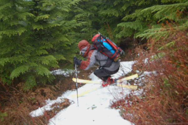
cass, sweet day, dood! especially the soggy hike down...17.5% on the jom is better than i thought! way to link the patches, just because they're there... ;)
Doesn't "pouring rain" give you some extra points to your J-O-M? I am no expert at that (and don't think I wanna be)...but it seems to me that it should ;-)
Cass: you're a bit late using the JOM stick; i pulled it out months ago:

btw, that patch of yours has waaaayyy too much vertical... ;D
btw, that patch of yours has waaaayyy too much vertical... ;D
Reply to this TR
Please login first: