April 26, 2006, Jolly Mtn-Sasse Mtn loop
4/26/06
WA Cascades East Slopes Central
3310
4
author=Charles link=topic=4595.msg19578#msg19578 date=1146174121]
I should have stayed just east of the ridge top around Pt. 5610, but thought I had a better idea and went west, traversing steep slopes that fell down into gullies.
Charles, yo-da-man! :D
Not even sore, just a 'little tired' after umpteen miles and ~6k vertical!? <jaw drops open in awe>
Gee, forgot to mention staying to the east. Fall down to the west is right; a long fall in spots. :)
Maybe an interesting pic or two tomorrow.
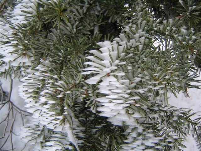
It was great to see you at my campsite Charles. Although the next day was quite beautiful, it remained cloudy till after daylight, so there was no freeze. Nice touring, but no good turns. On the way up the ridge at ~ 5600' Thursday morning, the needles on the fir trees were rimed in a most interesting way.
Unlike the rather amorphous riming you often see after a winter storm, each needle had a knife sharp, wedge shaped bit of ice that extended out as much as a half inch. Presumably the riming was caused by the small cloud that was forming just upwind of the ridge here.
As I was skiing back, the sun came up from a direction directly opposite the wind, warming the needles and causing all these little wedges to fall off by the thousands as I skied under them. Quite wonderful.
So this explains the tracks I encountered on the ridge to Jolly! If you got a late start, Charles, I am not sure what to call my start…
One comment on the route: I parked the car at Cayuse Horse Camp and more or less followed trail 1307 to the top of the ridge ~ 5600’. I say “more or less” because more than once in the middle of the forest I began to question my commitment to navigating without GPS help. :-[ (Every year my resolve not to buy a GPS unit weakens a bit, nudged along by thrashes below treeline.)
After popping out on the ridge – and finally getting a view of Jolly – it was obvious by Charles’ tracks that someone knew an easier way up to that point. So after visiting Jolly I followed Charles’ tracks back toward road 4315. It was late and I was tired, so I was not tempted to follow the tracks when they swung south toward Sasse. That sounds like a really nice loop, however.
Road 4315 seems to offer a better way up than the north side of Salmon la Sac creek (the way I came up), with snow starting at 2850’. And cutting the road’s switchbacks offered nice skiing through trees on the way down. But skiing down the road is tedious and not much fun, imho.
By the time I came off Jolly, around 4:15 pm, the top inch or two of snow were mushy but firm underneath. I thought the skiing was pretty prime.
author=Larry_R link=topic=4595.msg19590#msg19590 date=1146182999]
Gee, forgot to mention staying to the east.
Yes, I think you did forget to mention that! Oh well, it added some spice to the tour. Thanks for the report from the next day, Larry. I find it educational to find out how accurate my guess about the next day's snow conditions actually was (I did pretty well this time).
roald, welcome, and sorry I missed you (though not too sorry because then I would have been really late getting back). As I climbed up 4315 I kept looking north to your route, wondering what it would be like. I'm also a holdout against getting a GPS, although I did recently get an altimeter. I have found that having no other choice than to interpret the map against what I am encountering enables me to keep getting better at map navigating, and I worry that if I got a GPS that I would lose that skill. Also, I kind of like the feeling of being lost in the woods when I actually know pretty well where I am and where I need to go.
Reply to this TR
Please login first: