May 3, 2019, - Goat Mtn / Hannegan High Route fail
5/3/19
WA Cascades West Slopes North (Mt Baker)
1653
3
While hiking the Hannegan Pass trail last week en route to the Pickets, I got to thinking it'd be fun to try skiing the north ridgeline of the Ruth Creek valley from Goat Mtn to Hannegan Pass, then return via the trail. A few summits along the way would be Goat W & E peaks, Mamie Peak, Granite Mountain, Hannegan Peak, and if one were feeling sporty, a slight side trip could include the indulgent-sounding Mt Chardonnay, or even Ruth Mtn. (Caltopo map)
I am going to assume this has been done before, but I'm not super in tune with the ski community so I've never heard of it. Anyway, the name Hannegan High Route seems to fit nicely for this tour.
I ski Goat once or twice each season and had thought about this route before, but the long skin back down the road turned me off, not to mention just doing 1 lap on Goat is around 4.5k of gain. With the road fully melted out now, I figured I could do a bike shuttle and make the whole thing more palatable. I also used my skimo setup since my feet are still pretty tender from our last trip and I figured the light skis might be helpful on a longer day.
A comically late start was made even more tragic when, after having ridden my bike from my stashed car at the end of FR32 (Hannegan Pass TH) back to the Goat Mtn trailhead, I realized I'd left my skins in car while trying to pack quickly. So I biked 20 minutes uphill, retrieved the skins, and hit the trail around noon.
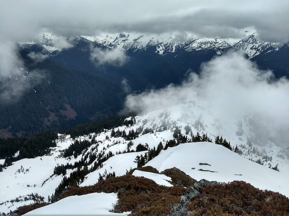
The Goat Mtn trail is in good shape and is a pleasant grade under thick canopy. Consistent snow started around 4100'. From there I skinned up a ridge that accesses the upper bowl on Goat West, but unfortunately the cloud ceiling was around 5500'. This was going to be a problem as the route is more or less all above 5500' once you get up Goat. I skinned up to around 6000' and took a break to see if the clouds would move out, but no luck. I climbed up to Goat's west peak (ca.6600'), still totally socked in, then decided to do a lap down the bowl to see if any clear sky was on the horizon.
The snow was pretty good, about an inch of slush on top of a firm base, but the light was flat so I needed to follow my skin track til I got below the cloud level. The skimo setup was a little squirrelly, but I don't have much time on it off-piste yet.
At this point, it was clear the clouds were not going to be moving anytime soon, so I did another lap then descended back down the trail, stashed my skis and boots, and once again biked back up the road to fetch the car.
I may give the route another shot this season, or just bin it for now and nab some more easily-accessible stuff while it's still there. If anyone is interested in trying out this tour, feel free to reach out. I'm pretty confident it's harder than I'm assuming it will be... a Caltopo route I plotted added up to around 8.5k of gain and 15 miles sticking more or less to the ridge.
Notes on Goat/FR32:
-snowline currently 4100'
-Goat Mtn trail is clear except for 2 or 3 minor trees
-FR32 is driveable to within approx 100yds of the road washout just before the Hannegan TH/campground. In fact I chatted with a FS crew that was clearing the road of all trees from the winter today (road was passable before, but tight in spots)
-Mt Baker ski resort is now closed but appeared to be plenty of snow over there while viewing from Goat Mtn
Pics:
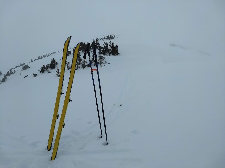
1. looking down
2. looking up
I am going to assume this has been done before, but I'm not super in tune with the ski community so I've never heard of it. Anyway, the name Hannegan High Route seems to fit nicely for this tour.
I ski Goat once or twice each season and had thought about this route before, but the long skin back down the road turned me off, not to mention just doing 1 lap on Goat is around 4.5k of gain. With the road fully melted out now, I figured I could do a bike shuttle and make the whole thing more palatable. I also used my skimo setup since my feet are still pretty tender from our last trip and I figured the light skis might be helpful on a longer day.
A comically late start was made even more tragic when, after having ridden my bike from my stashed car at the end of FR32 (Hannegan Pass TH) back to the Goat Mtn trailhead, I realized I'd left my skins in car while trying to pack quickly. So I biked 20 minutes uphill, retrieved the skins, and hit the trail around noon.
The Goat Mtn trail is in good shape and is a pleasant grade under thick canopy. Consistent snow started around 4100'. From there I skinned up a ridge that accesses the upper bowl on Goat West, but unfortunately the cloud ceiling was around 5500'. This was going to be a problem as the route is more or less all above 5500' once you get up Goat. I skinned up to around 6000' and took a break to see if the clouds would move out, but no luck. I climbed up to Goat's west peak (ca.6600'), still totally socked in, then decided to do a lap down the bowl to see if any clear sky was on the horizon.
The snow was pretty good, about an inch of slush on top of a firm base, but the light was flat so I needed to follow my skin track til I got below the cloud level. The skimo setup was a little squirrelly, but I don't have much time on it off-piste yet.
At this point, it was clear the clouds were not going to be moving anytime soon, so I did another lap then descended back down the trail, stashed my skis and boots, and once again biked back up the road to fetch the car.
I may give the route another shot this season, or just bin it for now and nab some more easily-accessible stuff while it's still there. If anyone is interested in trying out this tour, feel free to reach out. I'm pretty confident it's harder than I'm assuming it will be... a Caltopo route I plotted added up to around 8.5k of gain and 15 miles sticking more or less to the ridge.
Notes on Goat/FR32:
-snowline currently 4100'
-Goat Mtn trail is clear except for 2 or 3 minor trees
-FR32 is driveable to within approx 100yds of the road washout just before the Hannegan TH/campground. In fact I chatted with a FS crew that was clearing the road of all trees from the winter today (road was passable before, but tight in spots)
-Mt Baker ski resort is now closed but appeared to be plenty of snow over there while viewing from Goat Mtn
Pics:
1. looking down
2. looking up
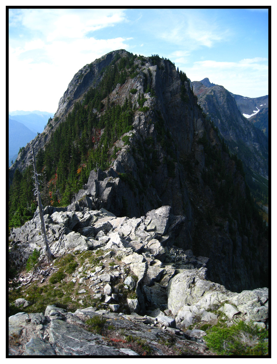
I've done that traverse! And it's was gloriously beautiful and full of blueberries....in September. Obviously getting around Mamie Peak will be the crux of your mission. Pretty deep and steep gullies on the north side will need to be negotiated. Skiing the 4th class knife edge ridge crest will not be an option.
Ah, thanks for the beta! I recognize your name as having put up a climbing route on Mamie - am I correct?
I don't suppose you have any pics you could share of when you traversed it? Was that in summer then?
I went to Hannegan Peak from Hannegan Pass a few winter's back and it was super mellow, but sounds like I'll want to do some Google Earth work before I head back.
Cheers,
Peter
I don't suppose you have any pics you could share of when you traversed it? Was that in summer then?
I went to Hannegan Peak from Hannegan Pass a few winter's back and it was super mellow, but sounds like I'll want to do some Google Earth work before I head back.
Cheers,
Peter
Mamie Peak from the east. I did some serious exposed scrambling to get across this thing.
Old TR Here
Being up on the summit amid some seriously nice granite is what finally inspired me to develop some pitches on the south face.
Old TR Here
Being up on the summit amid some seriously nice granite is what finally inspired me to develop some pitches on the south face.
Reply to this TR
Please login first: