Jan 26-28, 2019, Mt St Helens, Worm Flows True Summit
1/26/19
WA Cascades West Slopes South (Mt Rainier)
1442
1
Just a quick pair of micro TRs, which I originally wrote as part of my reply to CliffedDoubt's Jan 27th St Helens TR, but decided to post separately in a slightly expanded version instead:
January 26, 2019, Mount Saint Helens, Worm Flows to True Summit, Smooth Untracked Corn!!
January 28, 2019, Mount Saint Helens, Worm Flows to Crater Rim, Hard Frozen Corn!@#$%
Skied the Worm Flows route solo in very nice smooth untracked corn snow conditions on Saturday, January 26. Skinned continuously all the way from the climber register at the sno-park up to the true summit at 8333 ft, using ski crampons above 7000 ft and angling leftward away from the standard route starting at 7700 ft (if you want to see or ski the true summit, this way is far better than the up-down traverse along the crater rim from where the standard route tops out). Was the only one to skin up to the true summit on Saturday, putting in a skintrack with a few steep switchbacks in softened corn up the bowl just SE of the summit, and possibly the only one to ski from the summit (or maybe two??, there was a faint ski track visible below the crater rim), out of over 100 skiers.
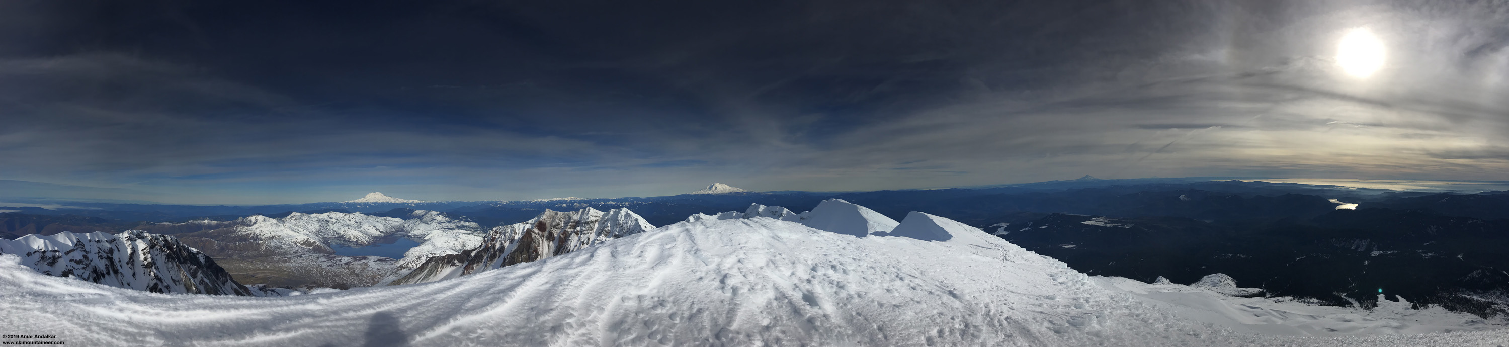
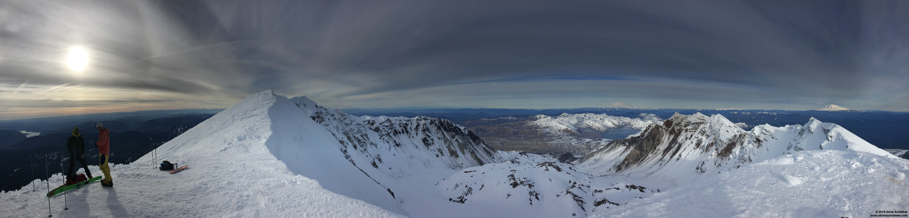
Panorama spanning over 270 ° from the true summit with solar halo at right, with Mounts Rainier, Adams, and Hood visible in the distance to the north, east, and south. (click for triple-size version)
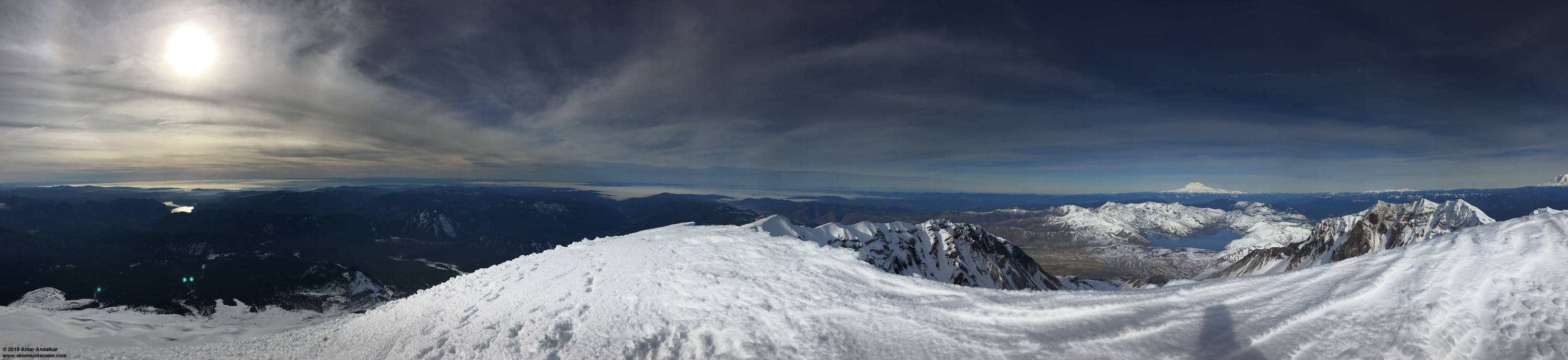
Panorama spanning over 270 ° from the true summit in the opposite direction with solar halo at left, providing a full 360 ° view with the previous shot. (click for triple-size version)
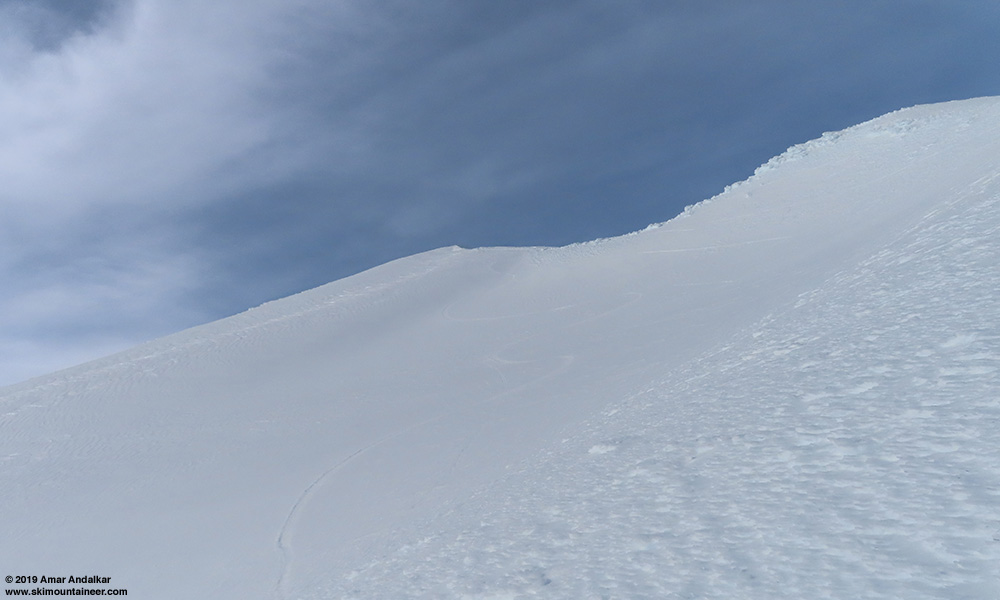
Slightly sketchy to ski off the true summit this time for the uppermost 100 ft, down a narrow 10-20 ft corridor of smoother snow between the huge cliff drop into the crater on the left and a large field of nasty ice fins on the right. Mostly nice corn after that uppermost bit by carefully choosing the optimal aspects, with a few sections of moderate ice fins to cross on the upper slopes above 7700 ft between areas of smooth corn while angling back towards the ascent route.
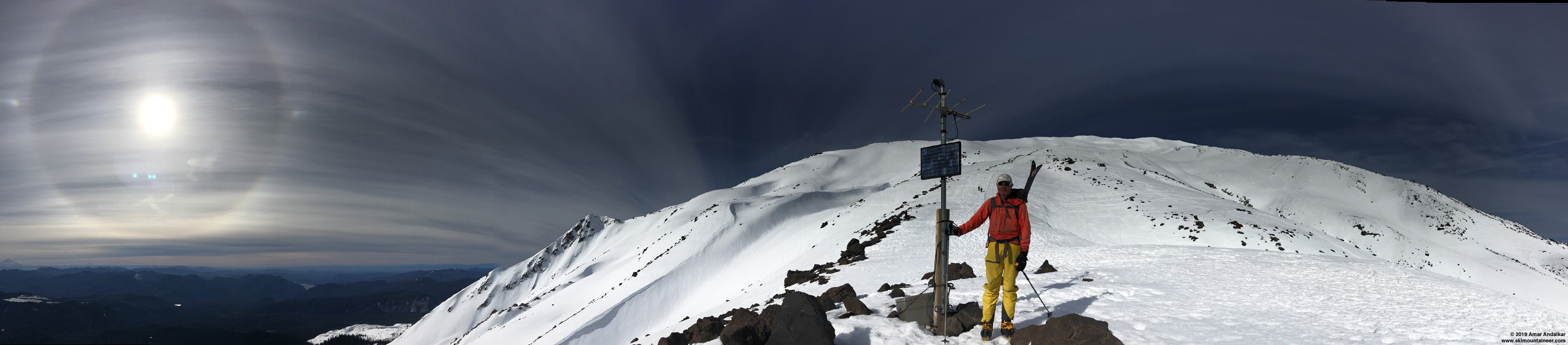
Ski tracks in nice corn in the bowl just SE of the true summit, with my switchbacking skin track faintly visible too. Some high clouds thickened and ruined the lighting.
Crossed over the ascent route and skied a fully untracked line on the most sunlit slopes, via a series of bowls far to the east of the ascent route down to treeline, and then followed the correct gully system to intersect the standard trail at Chocolate Falls 3700 ft. Skied all the way back down to the parking lot too without removing skis, gingerly crossing the few short dirt patches below 2850 ft.
Went back again on Monday, January 28, with 2 partners and was shocked by how much the trail had melted out in the first 0.6 miles to 2850 ft: the loss of only 1-2 inches of compacted snow down there had created lengthy bare patches totaling hundreds of yards! And even worse than that, strong cold easterly pass flow of 20-30mph had arisen overnight, along with a thicker-than-forecast layer of high clouds blocking a large fraction of the much-needed solar radiation. That combination kept the slopes solidly frozen and made skinning difficult even with ski crampons, needing foot crampons even in sections from 4700-6000 ft and then definitely above 7000 ft to reach the crater rim.
Panorama spanning over 240 ° from seismic station HSR at 5600 ft, with a multiple solar halo display at left including the 22-degree circle plus 2 bright sundogs. (click for triple-size version)
Panorama spanning over 270 ° from the crater rim near 8200 ft, with solar halo at left, the true summit far away along the rim at left center, and Mounts Rainier and Adams visible in the distance to the north and east. (click for triple-size version)
And despite delaying our arrival at the rim to 3pm and choosing the sunniest aspects for the descent, the frozen corn never properly softened for good skiing. It was solidly frozen above 6000 ft, and only barely softened in places below that. In fact, by far the best skiing of the day was the smooth corn-like surface of the Swift Ski Trail in the forest below 3600 ft. Very disappointing to not get good ski conditions above treeline, but still a very nice day out on the volcano. Just goes to show once again how a slight change in weather on an otherwise beautiful day can make a huge difference in snow conditions.
As usual in my TRs, here are the weather forecasts for both days, using the NWS Rainier forecast as a nearby proxy:
[tt]
Mount Rainier Recreational Forecast
National Weather Service Seattle WA
405 AM PST Sat Jan 26 2019
SYNOPSIS...An upper level ridge, with the ridge axis offshore, will remain over the park through Tuesday. A weather system will try and move through the ridge Wednesday or Thursday with another system on Friday.
IMPACTS...Strong winds near the summit will make it difficult to move safely and could produce local whiteout conditions on Sunday. A high level of skill and experience in alpine terrain, including use of GPS, is recommended for navigation and camping in these conditions.
SATURDAY...Sunny. Freezing level near 11000 feet.
SATURDAY NIGHT...Partly cloudy. Freezing level near 11000 feet.
SUNDAY...Sunny. Freezing level near 9500 feet.
SUNDAY NIGHT...Partly cloudy. Freezing level near 8500 feet.
MONDAY...Sunny. Freezing level near 6500 feet.
Temperature and wind forecasts for selected locations.
Sat Sat Sun Sun Mon
Night Night
Summit (14411 FT) 17 12 12 9 9
NW 25 W 30 NW 40 NW 20 NW 5
Camp Muir(10188 FT) 37 34 29 28 28
NW 25 W 25 NW 30 NW 10 SE 5
Paradise (5420 FT) 50 38 45 29 39
CALM NW 10 NE 5 E 15 E 15
Longmire (2760 FT) 57 41 53 34 46
SE 5 NW 5 S 5 E 15 E 20
++ Temperatures and wind for the summit and Camp Muir are average
conditions expected in the free air at those elevations.
++ Temperatures for Paradise and Longmire are the expected highs and
lows. Wind is the average wind expected during that period.
Extended Forecast...
MONDAY NIGHT...Mostly clear. Freezing level near 9000 feet.
TUESDAY...Mostly sunny. Freezing level near 8000 feet.
TUESDAY NIGHT...Mostly cloudy. Freezing level near 7500 feet.
WEDNESDAY...Mostly cloudy with a chance of showers. Snow level near 3500 feet.
WEDNESDAY NIGHT...Mostly cloudy with a chance of showers. Snow level near 4000 feet.
THURSDAY...Mostly cloudy with a chance of showers. Snow level near 4500 feet.
THURSDAY NIGHT...Mostly cloudy with a chance of showers. Snow level near 5000 feet.
FRIDAY...Rain and snow likely. Snow level near 6000 feet.
[/tt]
[tt]
Mount Rainier Recreational Forecast
National Weather Service Seattle WA
412 AM PST Mon Jan 28 2019
SYNOPSIS...Upper level ridge remaining over the area through Tuesday. Low level offshore flow increasing Monday then decreasing on Tuesday. Next system moving by far enough to the west and south on Wednesday for another dry day. A front will arrive late Thursday into Friday with cool and unsettled conditions for the weekend.
MONDAY...Sunny. Freezing level near 9000 feet.
MONDAY NIGHT...Mostly clear. Freezing level near 10000 feet decreasing to 8000 feet after midnight.
TUESDAY...Sunny. Freezing level near 5000 feet increasing to 8500 feet in the afternoon.
TUESDAY NIGHT...Partly cloudy in the evening then becoming mostly cloudy. Freezing level near 8500 feet.
WEDNESDAY...Mostly cloudy. Freezing level near 8000 feet.
Temperature and wind forecasts for selected locations.
Mon Mon Tue Tue Wed
Night Night
Summit (14411 FT) 10 10 11 12 13
W 15 NW 20 NW 15 W 10 W 15
Camp Muir(10188 FT) 29 30 28 28 27
W 10 NW 15 NW 10 W 10 W 15
Paradise (5420 FT) 45 26 43 28 44
NE 15 NE 10 E 10 NW 5 W 5
Longmire (2760 FT) 48 32 47 33 48
E 15 E 10 E 5 E 5 SW 5
++ Temperatures and wind for the summit and Camp Muir are average
conditions expected in the free air at those elevations.
++ Temperatures for Paradise and Longmire are the expected highs and
lows. Wind is the average wind expected during that period.
Extended Forecast...
WEDNESDAY NIGHT...Mostly cloudy. Freezing level near 8000 feet.
THURSDAY...Partly sunny in the morning then becoming cloudy. A chance of rain and snow. Snow level near 5000 feet.
THURSDAY NIGHT...Rain and snow. Snow level near 5000 feet.
FRIDAY...Rain and snow. Snow level near 4500 feet.
FRIDAY NIGHT...Showers. Snow level near 4000 feet.
SATURDAY...Showers. Snow level near 3500 feet.
SATURDAY NIGHT...Showers. Snow level near 2500 feet.
SUNDAY...Showers likely. Snow level near 2500 feet.
[/tt]
January 26, 2019, Mount Saint Helens, Worm Flows to True Summit, Smooth Untracked Corn!!
January 28, 2019, Mount Saint Helens, Worm Flows to Crater Rim, Hard Frozen Corn!@#$%
Skied the Worm Flows route solo in very nice smooth untracked corn snow conditions on Saturday, January 26. Skinned continuously all the way from the climber register at the sno-park up to the true summit at 8333 ft, using ski crampons above 7000 ft and angling leftward away from the standard route starting at 7700 ft (if you want to see or ski the true summit, this way is far better than the up-down traverse along the crater rim from where the standard route tops out). Was the only one to skin up to the true summit on Saturday, putting in a skintrack with a few steep switchbacks in softened corn up the bowl just SE of the summit, and possibly the only one to ski from the summit (or maybe two??, there was a faint ski track visible below the crater rim), out of over 100 skiers.
Panorama spanning over 270 ° from the true summit with solar halo at right, with Mounts Rainier, Adams, and Hood visible in the distance to the north, east, and south. (click for triple-size version)
Panorama spanning over 270 ° from the true summit in the opposite direction with solar halo at left, providing a full 360 ° view with the previous shot. (click for triple-size version)
Slightly sketchy to ski off the true summit this time for the uppermost 100 ft, down a narrow 10-20 ft corridor of smoother snow between the huge cliff drop into the crater on the left and a large field of nasty ice fins on the right. Mostly nice corn after that uppermost bit by carefully choosing the optimal aspects, with a few sections of moderate ice fins to cross on the upper slopes above 7700 ft between areas of smooth corn while angling back towards the ascent route.
Ski tracks in nice corn in the bowl just SE of the true summit, with my switchbacking skin track faintly visible too. Some high clouds thickened and ruined the lighting.
Crossed over the ascent route and skied a fully untracked line on the most sunlit slopes, via a series of bowls far to the east of the ascent route down to treeline, and then followed the correct gully system to intersect the standard trail at Chocolate Falls 3700 ft. Skied all the way back down to the parking lot too without removing skis, gingerly crossing the few short dirt patches below 2850 ft.
Went back again on Monday, January 28, with 2 partners and was shocked by how much the trail had melted out in the first 0.6 miles to 2850 ft: the loss of only 1-2 inches of compacted snow down there had created lengthy bare patches totaling hundreds of yards! And even worse than that, strong cold easterly pass flow of 20-30mph had arisen overnight, along with a thicker-than-forecast layer of high clouds blocking a large fraction of the much-needed solar radiation. That combination kept the slopes solidly frozen and made skinning difficult even with ski crampons, needing foot crampons even in sections from 4700-6000 ft and then definitely above 7000 ft to reach the crater rim.
Panorama spanning over 240 ° from seismic station HSR at 5600 ft, with a multiple solar halo display at left including the 22-degree circle plus 2 bright sundogs. (click for triple-size version)
Panorama spanning over 270 ° from the crater rim near 8200 ft, with solar halo at left, the true summit far away along the rim at left center, and Mounts Rainier and Adams visible in the distance to the north and east. (click for triple-size version)
And despite delaying our arrival at the rim to 3pm and choosing the sunniest aspects for the descent, the frozen corn never properly softened for good skiing. It was solidly frozen above 6000 ft, and only barely softened in places below that. In fact, by far the best skiing of the day was the smooth corn-like surface of the Swift Ski Trail in the forest below 3600 ft. Very disappointing to not get good ski conditions above treeline, but still a very nice day out on the volcano. Just goes to show once again how a slight change in weather on an otherwise beautiful day can make a huge difference in snow conditions.
As usual in my TRs, here are the weather forecasts for both days, using the NWS Rainier forecast as a nearby proxy:
[tt]
Mount Rainier Recreational Forecast
National Weather Service Seattle WA
405 AM PST Sat Jan 26 2019
SYNOPSIS...An upper level ridge, with the ridge axis offshore, will remain over the park through Tuesday. A weather system will try and move through the ridge Wednesday or Thursday with another system on Friday.
IMPACTS...Strong winds near the summit will make it difficult to move safely and could produce local whiteout conditions on Sunday. A high level of skill and experience in alpine terrain, including use of GPS, is recommended for navigation and camping in these conditions.
SATURDAY...Sunny. Freezing level near 11000 feet.
SATURDAY NIGHT...Partly cloudy. Freezing level near 11000 feet.
SUNDAY...Sunny. Freezing level near 9500 feet.
SUNDAY NIGHT...Partly cloudy. Freezing level near 8500 feet.
MONDAY...Sunny. Freezing level near 6500 feet.
Temperature and wind forecasts for selected locations.
Sat Sat Sun Sun Mon
Night Night
Summit (14411 FT) 17 12 12 9 9
NW 25 W 30 NW 40 NW 20 NW 5
Camp Muir(10188 FT) 37 34 29 28 28
NW 25 W 25 NW 30 NW 10 SE 5
Paradise (5420 FT) 50 38 45 29 39
CALM NW 10 NE 5 E 15 E 15
Longmire (2760 FT) 57 41 53 34 46
SE 5 NW 5 S 5 E 15 E 20
++ Temperatures and wind for the summit and Camp Muir are average
conditions expected in the free air at those elevations.
++ Temperatures for Paradise and Longmire are the expected highs and
lows. Wind is the average wind expected during that period.
Extended Forecast...
MONDAY NIGHT...Mostly clear. Freezing level near 9000 feet.
TUESDAY...Mostly sunny. Freezing level near 8000 feet.
TUESDAY NIGHT...Mostly cloudy. Freezing level near 7500 feet.
WEDNESDAY...Mostly cloudy with a chance of showers. Snow level near 3500 feet.
WEDNESDAY NIGHT...Mostly cloudy with a chance of showers. Snow level near 4000 feet.
THURSDAY...Mostly cloudy with a chance of showers. Snow level near 4500 feet.
THURSDAY NIGHT...Mostly cloudy with a chance of showers. Snow level near 5000 feet.
FRIDAY...Rain and snow likely. Snow level near 6000 feet.
[/tt]
[tt]
Mount Rainier Recreational Forecast
National Weather Service Seattle WA
412 AM PST Mon Jan 28 2019
SYNOPSIS...Upper level ridge remaining over the area through Tuesday. Low level offshore flow increasing Monday then decreasing on Tuesday. Next system moving by far enough to the west and south on Wednesday for another dry day. A front will arrive late Thursday into Friday with cool and unsettled conditions for the weekend.
MONDAY...Sunny. Freezing level near 9000 feet.
MONDAY NIGHT...Mostly clear. Freezing level near 10000 feet decreasing to 8000 feet after midnight.
TUESDAY...Sunny. Freezing level near 5000 feet increasing to 8500 feet in the afternoon.
TUESDAY NIGHT...Partly cloudy in the evening then becoming mostly cloudy. Freezing level near 8500 feet.
WEDNESDAY...Mostly cloudy. Freezing level near 8000 feet.
Temperature and wind forecasts for selected locations.
Mon Mon Tue Tue Wed
Night Night
Summit (14411 FT) 10 10 11 12 13
W 15 NW 20 NW 15 W 10 W 15
Camp Muir(10188 FT) 29 30 28 28 27
W 10 NW 15 NW 10 W 10 W 15
Paradise (5420 FT) 45 26 43 28 44
NE 15 NE 10 E 10 NW 5 W 5
Longmire (2760 FT) 48 32 47 33 48
E 15 E 10 E 5 E 5 SW 5
++ Temperatures and wind for the summit and Camp Muir are average
conditions expected in the free air at those elevations.
++ Temperatures for Paradise and Longmire are the expected highs and
lows. Wind is the average wind expected during that period.
Extended Forecast...
WEDNESDAY NIGHT...Mostly cloudy. Freezing level near 8000 feet.
THURSDAY...Partly sunny in the morning then becoming cloudy. A chance of rain and snow. Snow level near 5000 feet.
THURSDAY NIGHT...Rain and snow. Snow level near 5000 feet.
FRIDAY...Rain and snow. Snow level near 4500 feet.
FRIDAY NIGHT...Showers. Snow level near 4000 feet.
SATURDAY...Showers. Snow level near 3500 feet.
SATURDAY NIGHT...Showers. Snow level near 2500 feet.
SUNDAY...Showers likely. Snow level near 2500 feet.
[/tt]
Amar,
Thanks as always for the detailed report. I thought about heading to Mt St Helens on Saturday but opted for some southeasterly-facing terrain on Mt Hood (white river canyon environs). It was near windless there and the sun was shining strongly enough to develop great spring-like snow conditions between 5 and 9,000-feet. I was thinking along similar lines to what you found Monday, that seeking spring this time of year is fickle, if the high clouds are a little thicker or the wind a bit stronger, the snow can remain stubbornly frozen, but fortunately things lined up on Saturday.
Thanks as always for the detailed report. I thought about heading to Mt St Helens on Saturday but opted for some southeasterly-facing terrain on Mt Hood (white river canyon environs). It was near windless there and the sun was shining strongly enough to develop great spring-like snow conditions between 5 and 9,000-feet. I was thinking along similar lines to what you found Monday, that seeking spring this time of year is fickle, if the high clouds are a little thicker or the wind a bit stronger, the snow can remain stubbornly frozen, but fortunately things lined up on Saturday.
Reply to this TR
Please login first: