- Posts: 1460
- Thank you received: 16
Feb 25, 2018 - Mirror Lake snowmobile avalanche
- Lowell_Skoog
-
 Topic Author
- User
-

Less
More
8 years 1 month ago - 8 years 1 month ago #160103
by Lowell_Skoog
I'm starting this thread to collect information and thoughts about the snowmobile avalanche accident that occurred on Sunday, Feb 25, 2018 near Mirror Lake, south of Snoqualmie Pass.Â
My condolences go out to family and friends of Joseph Simenstad of Issaquah, identified in media reports as the victim of the fatal avalanche. Early media reports can be found here:
komonews.com/news/local/rescue-underway-...tal-springs-sno-park
www.kiro7.com/news/local/light-snow-fall...-mountains/706344846
www.king5.com/article/news/local/avalanc...e-pass/281-523231343
I also want to acknowledge that there are reports of two teenagers missing after a Sunday snowshoeing trip near Alpental. A search is underway for them. I'm hoping for the best in that search, but won't comment further here. For this thread, I'm going to focus on the Mirror Lake snowmobiling incident.
The main reason I want to discuss this is because the Mirror Lake accident occurred close to the route of the Mountaineers Patrol Race, which took place on Saturday, Feb 24, one day before the snowmobile avalanche. My team raced in the Patrol Race, and other friends were either in the race or took part as organizers.
Avalanche risk was very much a consideration during planning of this year's Patrol Race. Based on field observations and NWAC hazard forecasts, the decision was made late Friday evening to go forward with the race. The NWAC avalanche forecast issued Friday evening (2/23) and updated Saturday morning (2/24) was for Considerable avalanche danger at all elevations on Saturday for the Patrol Race vicinity:
www.nwac.us/avalanche-forecast/avalanche.../cascade-east-south/
www.nwac.us/avalanche-forecast/avalanche.../cascade-west-south/
Sunday's forecast from NWAC raised the avalanche danger rating to High at all elevations:
www.nwac.us/avalanche-forecast/avalanche.../cascade-west-south/
When the decision was made to go forward with Saturday's race, a few teams decided not to run, but most did run (including mine).
The Patrol Race organizers notified all teams that if they decided to stop to dig a pit or otherwise evaluate snow conditions more carefully during the race, they would be allowed to deduct any time spent for this from their race time, by taking digital photos of their group at the start and end of their safety evaluations. Photo timestamps would be used to deduct this time from their race time. I'm not aware that any teams decided to do this during the race.
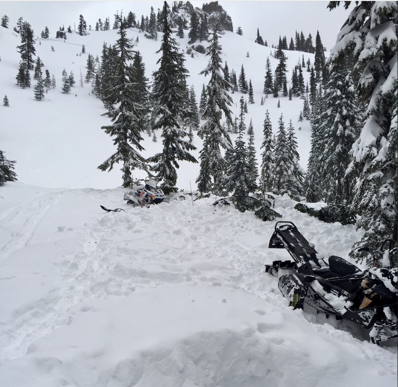
There were no incidents on Saturday during the race. The fatal snowmobile avalanche occurred one day later, on Sunday (after the NWAC forecast raised the hazard rating to High at all elevations). A photograph posted on the KOMO-TV website shows the scene of the avalanche. (See opening photo of this thread.)
At least two snowmobiles can be seen in the photo. Reports indicate that the snowmobile party included five people. Two were caught in the avalanche and one of those was rescued alive.
Near the upper-left corner of the photograph, there appears to be a fracture line visible just below the ridgeline. I don't know for sure if that fracture is associated with the fatal avalanche.
I've skied the Snoqualmie-to-Stampede Pass Patrol Race route through the Mirror Lake area at least 10 times since 2001. I've raced in every Patrol Race since the event was revived in 2014. I'd like to apply that experience to help think about the Patrol Race and our decision-making going forward.
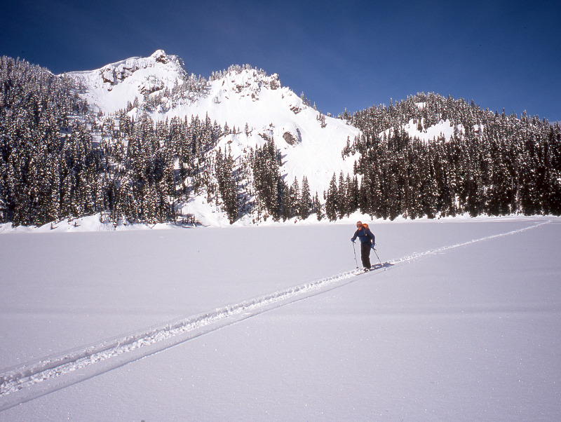
Looking at the photograph above, I'm confident that the site pictured is not actually on the Patrol Race route. The following photo shows John Mauro crossing Mirror Lake on the Patrol Race route in 2004. The above-treeline terrain in this photo does not match the scene of the Feb 25 avalanche, and the normal ski route doesn't go anywhere near that terrain.
While media reports have said that the fatal avalanche occurred near Mirror Lake, I don't think the KOMO-TV photo shows the Mirror Lake basin. My guess is that this may be in or near the Cottonwood Lake basin, which is about 1/2 mile ENE of Mirror Lake and about 300ft lower. It would be good to have more clarity on the location.
The Patrol Race route never crosses terrain as open as that shown in the KOMO-TV photo. It does cross a few, much smaller open slopes, but none as large as what the photo shows. In the vicinity of Tinkham Pass and Mirror Lake (above its outlet) the Patrol Race route travels through old-growth forest. The photo of the Feb 25 avalanche location shows terrain that is considerably more open and alpine than where the Patrol Race route travels.
Media reports indicate that the Feb 25 avalanche occurred while the snowmobile party was eating lunch at the base of the avalanche slope. It's not known whether they had ridden the slope that avalanched.
I'm posting this information to provide a foundation for discussing future planning for the Patrol Race. At this time, I don't have any criticism of the decision to hold the race, and I don't recall any serious misgivings about the conditions I observed while we were skiing the route on Feb 24.
I welcome your thoughts and observations.
Feb 25, 2018 - Mirror Lake snowmobile avalanche was created by Lowell_Skoog
I'm starting this thread to collect information and thoughts about the snowmobile avalanche accident that occurred on Sunday, Feb 25, 2018 near Mirror Lake, south of Snoqualmie Pass.Â
My condolences go out to family and friends of Joseph Simenstad of Issaquah, identified in media reports as the victim of the fatal avalanche. Early media reports can be found here:
komonews.com/news/local/rescue-underway-...tal-springs-sno-park
www.kiro7.com/news/local/light-snow-fall...-mountains/706344846
www.king5.com/article/news/local/avalanc...e-pass/281-523231343
I also want to acknowledge that there are reports of two teenagers missing after a Sunday snowshoeing trip near Alpental. A search is underway for them. I'm hoping for the best in that search, but won't comment further here. For this thread, I'm going to focus on the Mirror Lake snowmobiling incident.
The main reason I want to discuss this is because the Mirror Lake accident occurred close to the route of the Mountaineers Patrol Race, which took place on Saturday, Feb 24, one day before the snowmobile avalanche. My team raced in the Patrol Race, and other friends were either in the race or took part as organizers.
Avalanche risk was very much a consideration during planning of this year's Patrol Race. Based on field observations and NWAC hazard forecasts, the decision was made late Friday evening to go forward with the race. The NWAC avalanche forecast issued Friday evening (2/23) and updated Saturday morning (2/24) was for Considerable avalanche danger at all elevations on Saturday for the Patrol Race vicinity:
www.nwac.us/avalanche-forecast/avalanche.../cascade-east-south/
www.nwac.us/avalanche-forecast/avalanche.../cascade-west-south/
Sunday's forecast from NWAC raised the avalanche danger rating to High at all elevations:
www.nwac.us/avalanche-forecast/avalanche.../cascade-west-south/
When the decision was made to go forward with Saturday's race, a few teams decided not to run, but most did run (including mine).
The Patrol Race organizers notified all teams that if they decided to stop to dig a pit or otherwise evaluate snow conditions more carefully during the race, they would be allowed to deduct any time spent for this from their race time, by taking digital photos of their group at the start and end of their safety evaluations. Photo timestamps would be used to deduct this time from their race time. I'm not aware that any teams decided to do this during the race.
There were no incidents on Saturday during the race. The fatal snowmobile avalanche occurred one day later, on Sunday (after the NWAC forecast raised the hazard rating to High at all elevations). A photograph posted on the KOMO-TV website shows the scene of the avalanche. (See opening photo of this thread.)
At least two snowmobiles can be seen in the photo. Reports indicate that the snowmobile party included five people. Two were caught in the avalanche and one of those was rescued alive.
Near the upper-left corner of the photograph, there appears to be a fracture line visible just below the ridgeline. I don't know for sure if that fracture is associated with the fatal avalanche.
I've skied the Snoqualmie-to-Stampede Pass Patrol Race route through the Mirror Lake area at least 10 times since 2001. I've raced in every Patrol Race since the event was revived in 2014. I'd like to apply that experience to help think about the Patrol Race and our decision-making going forward.
Looking at the photograph above, I'm confident that the site pictured is not actually on the Patrol Race route. The following photo shows John Mauro crossing Mirror Lake on the Patrol Race route in 2004. The above-treeline terrain in this photo does not match the scene of the Feb 25 avalanche, and the normal ski route doesn't go anywhere near that terrain.
While media reports have said that the fatal avalanche occurred near Mirror Lake, I don't think the KOMO-TV photo shows the Mirror Lake basin. My guess is that this may be in or near the Cottonwood Lake basin, which is about 1/2 mile ENE of Mirror Lake and about 300ft lower. It would be good to have more clarity on the location.
The Patrol Race route never crosses terrain as open as that shown in the KOMO-TV photo. It does cross a few, much smaller open slopes, but none as large as what the photo shows. In the vicinity of Tinkham Pass and Mirror Lake (above its outlet) the Patrol Race route travels through old-growth forest. The photo of the Feb 25 avalanche location shows terrain that is considerably more open and alpine than where the Patrol Race route travels.
Media reports indicate that the Feb 25 avalanche occurred while the snowmobile party was eating lunch at the base of the avalanche slope. It's not known whether they had ridden the slope that avalanched.
I'm posting this information to provide a foundation for discussing future planning for the Patrol Race. At this time, I don't have any criticism of the decision to hold the race, and I don't recall any serious misgivings about the conditions I observed while we were skiing the route on Feb 24.
I welcome your thoughts and observations.
Last edit: 8 years 1 month ago by Lowell_Skoog.
Please Log in or Create an account to join the conversation.
- thunderchief
-

- User
-
Less
More
- Posts: 27
- Thank you received: 0
8 years 1 month ago #160104
by thunderchief
Replied by thunderchief on topic Re: Feb 25, 2018 - Mirror Lake snowmobile avalanche
There was a lot more snow and increased wind-loading Sat night into Sunday. Sunday's avy threat(note this is based purely on weather data and I was not out there to dig pits) looked much worse than Saturday, especially on downwind(easterly) aspects. Saturday I could see cautious playing in the hills... Sunday was a big red flag.
Also it sounds like the 2 kids at Alpy didnt make it
Also it sounds like the 2 kids at Alpy didnt make it
Please Log in or Create an account to join the conversation.
- Salal
-
- User
-
Less
More
- Posts: 53
- Thank you received: 0
8 years 1 month ago #160111
by Salal
Replied by Salal on topic Re: Feb 25, 2018 - Mirror Lake snowmobile avalanche
I think you might be right about it being in the cottonwood lake basin. I recognize that ridge as the one that holds the twin lakes couloir. I remember topping out after booting up it and looking down on that basin and seeing a couple groups of sleds in there on a past trip. My condolences to friends and family.
Please Log in or Create an account to join the conversation.
- bbrelje
-
- User
-
Less
More
- Posts: 13
- Thank you received: 0
8 years 1 month ago #160112
by bbrelje
Thanks for starting this discussion. I skied the Patrol Race last year. As a newer backcountry user, my threat filter is certainly set at a lower threshold. I remember thinking through about 6 potential avy areas of concern depending on the wind loading direction and my team felt comfortable passing through them in the conditions last year. I marked them out in this Caltopo map . It looked to me like most of them would require a natural release or a (very) remote trigger.
I was most concerned about the path I marked "SE Silver Peak slide path" since the start zone is high above in the alpine zone which we wouldn't be able to evaluate from deep in the forest. I don't know if it slides very often, but if it did it'd be really bad luck for those below. The satellite view shows the snapped trees extending far below the race route. There are a couple other less-recent and narrower paths further north on the E flank of Silver Peak as well.
If the winds were out of the east/NE, I thought there might be a couple potential trouble spots on the Summit West/Central ridge. The powerline clearcut extends far above the race route to the ridgetop where windloading could happen much more readily. On the west aspect the PCT winds its way through some locally steep and awkward areas - I'm sure those could locally slide given the right conditions even though it is mostly forested. If you took a ride there it could be awkward to travel below the trail for a rescue.
Replied by bbrelje on topic Re: Feb 25, 2018 - Mirror Lake snowmobile avalanche
The Patrol Race route never crosses terrain as open as that shown in the KOMO-TV photo. It does cross a few, much smaller open slopes, but none as large as what the photo shows. In the vicinity of Tinkham Pass and Mirror Lake (above its outlet) the Patrol Race route travels through old-growth forest. The photo of the Feb 25 avalanche location shows terrain that is considerably more open and alpine than where the Patrol Race route travels.
Thanks for starting this discussion. I skied the Patrol Race last year. As a newer backcountry user, my threat filter is certainly set at a lower threshold. I remember thinking through about 6 potential avy areas of concern depending on the wind loading direction and my team felt comfortable passing through them in the conditions last year. I marked them out in this Caltopo map . It looked to me like most of them would require a natural release or a (very) remote trigger.
I was most concerned about the path I marked "SE Silver Peak slide path" since the start zone is high above in the alpine zone which we wouldn't be able to evaluate from deep in the forest. I don't know if it slides very often, but if it did it'd be really bad luck for those below. The satellite view shows the snapped trees extending far below the race route. There are a couple other less-recent and narrower paths further north on the E flank of Silver Peak as well.
If the winds were out of the east/NE, I thought there might be a couple potential trouble spots on the Summit West/Central ridge. The powerline clearcut extends far above the race route to the ridgetop where windloading could happen much more readily. On the west aspect the PCT winds its way through some locally steep and awkward areas - I'm sure those could locally slide given the right conditions even though it is mostly forested. If you took a ride there it could be awkward to travel below the trail for a rescue.
Please Log in or Create an account to join the conversation.
- LangleyBackcountry
-
- User
-
Less
More
- Posts: 3
- Thank you received: 0
8 years 1 month ago #160113
by LangleyBackcountry
Replied by LangleyBackcountry on topic Re: Feb 25, 2018 - Mirror Lake snowmobile avalanche
I can confirm from SAR contacts that the slide was on the S-facing slope above and between the 2 Cottonwood Lakes. I cannot confirm any other details beyond what the news reported (I can't confirm the accuracy of that, either, since it was variously reported "at Crystal Springs Sno Park" and "on Stampede Pass").
As one of the patrollers on the race (I did checkpoint 1 to the finish) I can also assure you we are evaluating the process from our end. I hope I or one of my fellow patrollers will be able to fill in some insight into the decision-making process.
As one of the patrollers on the race (I did checkpoint 1 to the finish) I can also assure you we are evaluating the process from our end. I hope I or one of my fellow patrollers will be able to fill in some insight into the decision-making process.
Please Log in or Create an account to join the conversation.
- spindrift
-
- User
-
Less
More
- Posts: 1
- Thank you received: 0
8 years 1 month ago #160133
by spindrift
Replied by spindrift on topic Re: Feb 25, 2018 - Mirror Lake snowmobile avalanche
Thx for your thoughtful post Lowell. I was part of a five person sweep party from the start, through Windy Pass and to the checkpoint just past Cottonwood Lake. A few observations:
1 - We did see a natural avalanche, albeit small, not far before Tinkham Pass? (NE of Tinkham Peak). There was a 50' wide slide with a 10-12" crown on a convexity 75-100' feet above the skintrack. The slide did not come down to the track as it was stopped by a stand of mature and old growth trees. We saw evidence of two or three other slides away from the track during our sweep.
2 - By the time we came through, the skintrack across Mirror Lake was obliterated by snow machine tracks. There were also multiple ascent and two descent snow machine tracks high on the right side of the open slope just above John Mauro's head in the picture you attached. The slope angle and limited anchor points were optimal for a slide.
3 - For those who stayed on course, the Patrol Race track descended the mature stand of trees at 2:00 behind John in your picture. One party did descend into the Cottonwood Lake drainage instead of to Mirror. They ended up climbing out and then descended to Mirror on the main trail.
Please Log in or Create an account to join the conversation.