- Posts: 125
- Thank you received: 0
East/Norse Peak Fire, Do not wear white up there!
- Eric Lindahl
- [ejlindahl]
-
 Topic Author
- Offline
- Junior Member
-

Less
More
15 Oct 2017 22:28 - 16 Nov 2017 23:09 #230002
by Eric Lindahl
East/Norse Peak Fire, Do not wear white up there! was created by Eric Lindahl
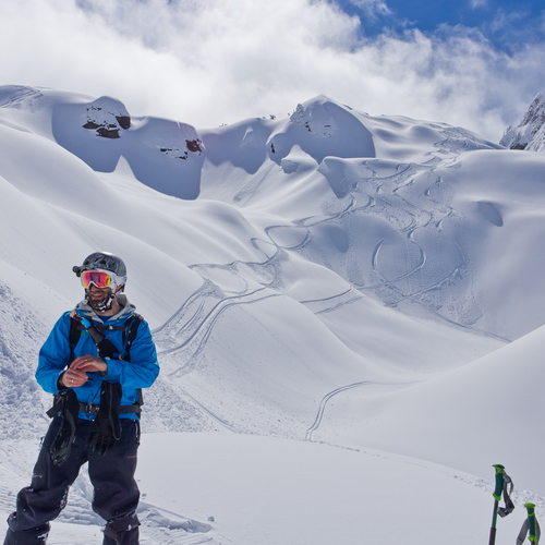
Finally got around to hiking up there to scope out the damage. Â Though our thoughts and prayers should really be turned to those in NorCal and Pueto Rico. Â The Norse Peak fire impact is very bad, and sad. Â You can see from the Crystal parking lot that most of the ~1-2 mile hill side is burnt nearly half way down toward the road. Â The entire hillside where I skin up to E Peak from Bullion Basin is mostly burnt. Â Totally blackened standing trees with straggly, bare, blackened limbs. Â The Basin itself and the trail to Crown Point is thankfully spared. Â Not many trees have actually fallen over but enough to make you look around for any that might be ready to go. Â Most of the summit ridgeline is burnt and ~80% of the trees in the basin on the back side of E. Peak are burnt. Â Lots more beyond that. There's some burnt trees heading down into Union Cr too. Â Some earth is really scorched, other areas not so bad. Â There are isolated pockets of wide spaced trees that were spared but mostly its a waste. Â I wonder how stability and anchoring of the snowpack will be affected now. Â If you are the type who occasionally brushes against tree bows while skiing down (yeah, we all do that) you will want to wear all black! Â What ever touches the soot/char covered trees will turn black. Â Its a mess. Â
Please Log in or Create an account to join the conversation.
- skykilo
- [skykilo]
-
- Offline
- Senior Member
-

Less
More
- Posts: 304
- Thank you received: 0
16 Oct 2017 09:09 - 16 Oct 2017 12:25 #230003
by skykilo
Replied by skykilo on topic Re: East/Norse Peak Fire, Do not wear white up there!
There is plenty of opportunity to ski/recreate in burnt forests here in New Mexico.Â
Are you careful enough to change pants and/or jackets without cross-contaminating your vehicle or couch, etc? It seems like this could lead to domestic conflict. Perhaps it's better to just learn to live with the stains on your ski garments when they happen.
There is an area at about 8,000 ft AMSL just above the lab here where we climb often in the summer. Saw two trees fall across the trail on separate days within the last month or two. This was from a fire in 2011. These hazards persist!
Please Log in or Create an account to join the conversation.
- Pete_H
- [Pete_H]
-
- Offline
- Junior Member
-
Less
More
- Posts: 140
- Thank you received: 0
16 Oct 2017 09:09 #230004
by Pete_H
Replied by Pete_H on topic Re: East/Norse Peak Fire, Do not wear white up there!
I know wildfires on the westside are a bit of an anomaly but wild fires are a natural part of the ecosystem. Plus it will probably open up some more ski terrain. I love skiing the burns over here on the eastside of the mountains.
Please Log in or Create an account to join the conversation.
- RonL
- [RonL]
-
- Offline
- Senior Member
-
Less
More
- Posts: 259
- Thank you received: 0
16 Oct 2017 10:22 #230005
by RonL
Replied by RonL on topic Re: East/Norse Peak Fire, Do not wear white up there!
Domestic conflicts are also part of the ecosystem. My house this weekend;
Wife: there is something really bad and chemically smelling in the laundry room. Did something spill?
RL: it's my socks
Wife: frowny face
Wife: there is something really bad and chemically smelling in the laundry room. Did something spill?
RL: it's my socks
Wife: frowny face
Please Log in or Create an account to join the conversation.
- Lowell_Skoog
- [Lowell_Skoog]
-

- Offline
- Platinum Member
-

Less
More
- Posts: 1460
- Thank you received: 16
16 Oct 2017 11:22 - 16 Oct 2017 13:19 #230006
by Lowell_Skoog
Replied by Lowell_Skoog on topic Re: East/Norse Peak Fire, Do not wear white up there!
Dreaming of the old days....

This photo was taken by Chuck Hessey in 1959 from the shoulder above the run now called Exterminator. A lot fewer trees back then!
I'm guessing there were huge fires in the old days. Fire suppression has enabled the trees to grow back in.
I'm not advocating for that sort of destruction, but you can sure see why folks thought Crystal Mountain was a good place for a ski area!
Please Log in or Create an account to join the conversation.
- Norseman
- [Norseman]
-
- Offline
- Junior Member
-
Less
More
- Posts: 55
- Thank you received: 0
16 Oct 2017 11:40 #229997
by Norseman
Replied by Norseman on topic Re: East/Norse Peak Fire, Do not wear white up there!
^ wow, that is almost unrecognizable. Thanks for drumming up the picture.
Please Log in or Create an account to join the conversation.
- Eric Lindahl
- [ejlindahl]
-
Topic Author
- Offline
- Junior Member
-
Less
More
- Posts: 125
- Thank you received: 0
16 Oct 2017 20:22 #230008
by Eric Lindahl
Replied by Eric Lindahl on topic Re: East/Norse Peak Fire, Do not wear white up there!
I meant to add to bring a garbage sack and spare clothes in case you really get into it.
I have heard that the slopes of the Crystal drainage were denuded of trees for structures and mine supports around the turn of the last century.
I often see really nice slopes where its obvious that fire had done its job of clearing decades before. I usually give thanks for that.
Cool picture Lowell. Thanks.
On another note, psa: There is a ~16" diameter fallen tree across the Bullion Basin trail about 1.5 miles up the trail. Its about hip level at the highest point. Unless we have a better than average snow year I think it will be a pain for every one who skins up there. Might be able to get around it ok once several feet of snow falls. But I am hoping the forest service or who ever is responsible will get up there with a chainsaw and take care of it........
Please Log in or Create an account to join the conversation.
- skibacks
- [skibacks]
-
- Offline
- Junior Member
-
Less
More
- Posts: 62
- Thank you received: 0
16 Oct 2017 23:43 #230010
by skibacks
Replied by skibacks on topic Re: East/Norse Peak Fire, Do not wear white up there!
Great beta Eric and what an awesome photo - thanks for sharing, Lowell. A great vista of Ted's Buttress which is the ridgeline where the shade meets the sun just right of the skier. There are some small trees now where the biggest trees are in the photo, just right of the skier's head. The bigger trees in the photo were "flushed" in a slide which nearly reached Forelaufer's Ski Club, decades ago There have been several avalanche accidents in Ted's over the years - usually just broken legs. The prevailing winds load the area left of the ridge. Kim Kircher noted that quite a few trees higher up were burned which could create a new starting zone. I am interested to see how the old slide path down valley near the Sand Flats will perform. There was a slide in 1972 that went from east to west and covered the BLVD with about 15-20 feet of snow & logs.
Please Log in or Create an account to join the conversation.
- r1de
- [r1de]
-
- Offline
- Junior Member
-
Less
More
- Posts: 90
- Thank you received: 0
16 Nov 2017 06:37 #230088
by r1de
Isn't this whole area still closed?
www.fs.usda.gov/alerts/mbs/alerts-notices
Please tell me I'm wrong.
Replied by r1de on topic Re: East/Norse Peak Fire, Do not wear white up there!
On another note, psa:  There is a ~16" diameter fallen tree across the Bullion Basin trail about 1.5 miles up the trail. Its about hip level at the highest point. Unless we have a better than average snow year I think it will be a pain for every one who skins up there. Might be able to get around it ok once several feet of snow falls. But I am hoping the forest service or who ever is responsible will get up there with a chainsaw and take care of it........
Isn't this whole area still closed?
www.fs.usda.gov/alerts/mbs/alerts-notices
Please tell me I'm wrong.
Please Log in or Create an account to join the conversation.
- Norseman
- [Norseman]
-
- Offline
- Junior Member
-
Less
More
- Posts: 55
- Thank you received: 0
16 Nov 2017 08:04 #230062
by Norseman
That is a closure that will be flat out ignored by the touring crowd (I hope). Good f'n luck enforcing it.
Replied by Norseman on topic Re: East/Norse Peak Fire, Do not wear white up there!
Isn't this whole area still closed?
www.fs.usda.gov/alerts/mbs/alerts-notices
Please tell me I'm wrong.
That is a closure that will be flat out ignored by the touring crowd (I hope). Good f'n luck enforcing it.
Please Log in or Create an account to join the conversation.
- Kiddch
- [Kiddch]
-
- Offline
- New Member
-

Less
More
- Posts: 24
- Thank you received: 0
16 Nov 2017 09:00 #230089
by Kiddch
Replied by Kiddch on topic Re: East/Norse Peak Fire, Do not wear white up there!
Wow. By the letter of the law, between the Baker-Snoqualmie closures in Pierce Co. and the Okanogan-Wenatchee closures in Yakima Co., widespread popular areas to the east and north of Crystal, including Norse Peak, East Peak, Cement Basin, Bullion Basin and Blue Bell, are under closure order.
Lots of interesting questions I can think of here, but maybe don't ask/don't tell is the approach, let people do what they are going to do? I guess we may not see many trip reports (cough....evidence....cough) out of those areas for a while.
Seriously, stay safe. When is the last experience the bc community has with widespread fire damage in that popular of a touring area, and how stability is effected?
Having already toured East Peak and Cement and Bullion Basins I was hoping to check out Blue Bell next. We'll see. Ridge from Crown Point to Three Way may get busier for a little. Hope this doesn't drive too much more traffic into south facing aspects where risks can be harder to manage.....
Please Log in or Create an account to join the conversation.
- CBAlliance
- [CBAlliance]
-
- Offline
- New Member
-
Less
More
- Posts: 29
- Thank you received: 0
16 Nov 2017 18:35 #230097
by CBAlliance
Replied by CBAlliance on topic Re: East/Norse Peak Fire, Do not wear white up there!
Called and talked to the FS office in Enumclaw today. Stated reason for the continued closure was that they need to go in and assess the area for public safety, due to the hazard of burned and weakened trees falling on people. I asked when this would happen, and was told it was weather dependent but they were trying to do it soon, and certainly before the closure expired on Dec 31st.
Not really clear on what would be assessed, or what sort of standards are required to re-open an area. We will come up with some sort of official missive soon to hopefully let the FS know how valuable these areas are to the ski community, but that's the word currently.
Not really clear on what would be assessed, or what sort of standards are required to re-open an area. We will come up with some sort of official missive soon to hopefully let the FS know how valuable these areas are to the ski community, but that's the word currently.
Please Log in or Create an account to join the conversation.
- Robie
- [Robie]
-
- Offline
- Premium Member
-

Less
More
- Posts: 554
- Thank you received: 0
16 Nov 2017 19:52 #230099
by Robie
Replied by Robie on topic Re: East/Norse Peak Fire, Do not wear white up there!
The Closure expires DEC ,31 2018 , more than a year from now. ??
Please Log in or Create an account to join the conversation.
- Norseman
- [Norseman]
-
- Offline
- Junior Member
-
Less
More
- Posts: 55
- Thank you received: 0
16 Nov 2017 20:07 #230100
by Norseman
Replied by Norseman on topic Re: East/Norse Peak Fire, Do not wear white up there!
Sounds like a dodge to me. FS site said the closure would last till December 2018... is that an error? And yeah, what would be "assessed", and over what area? Check out a few trees in Bullion and decide to uphold and enforce the BS closure for a whole year or beyond?
Please Log in or Create an account to join the conversation.
- Kneel Turner
- [Kneel Turner]
-
- Offline
- Senior Member
-
Less
More
- Posts: 379
- Thank you received: 1
16 Nov 2017 21:01 #230101
by Kneel Turner
Replied by Kneel Turner on topic Re: East/Norse Peak Fire, Do not wear white up there!
Trust them. They know what's best for you. They're with the Government.
Please Log in or Create an account to join the conversation.
- Eric Lindahl
- [ejlindahl]
-
Topic Author
- Offline
- Junior Member
-
Less
More
- Posts: 125
- Thank you received: 0
16 Nov 2017 22:11 #230103
by Eric Lindahl
Replied by Eric Lindahl on topic Re: East/Norse Peak Fire, Do not wear white up there!
Well, with an 88 mph gust on the 14th its pretty clear that the FS evaluation is superfluous. Simple, just don't go up there in wind over 40....... I suppose Mother nature will see fit to do random testing and evaluation throughout the season.
Please Log in or Create an account to join the conversation.
- Randito
- [Randito]
-
- Offline
- Elite Member
-

Less
More
- Posts: 960
- Thank you received: 1
17 Nov 2017 15:59 #230118
by Randito
Replied by Randito on topic Re: East/Norse Peak Fire, Do not wear white up there!
Closing burned areas for a few years following a forest fire is standard USFS practice. Risk of injury from falling trees is higher than regular old forest. Risk of flash flooding is higher Sole erosion is more of problem, etc. So there is some legitimacy to such closure orders, more so in summer than winter. However I tend to think a good portion of these closure orders is CYA on their part. More than CYA they probably don't want to expose USFS employees to the above risks patrolling burned areas until most of the weakened trees have fallen, soils stabilised, etc.
Please Log in or Create an account to join the conversation.
- Skier of the Hood
- [Skier of the Hood]
-
- Offline
- New Member
-
Less
More
- Posts: 38
- Thank you received: 3
18 Nov 2017 16:29 #230130
by Skier of the Hood
Replied by Skier of the Hood on topic Re: East/Norse Peak Fire, Do not wear white up there!
Dont ask dont tell?
Please Log in or Create an account to join the conversation.
- rippy
- [rippy]
-
- Offline
- Junior Member
-
Less
More
- Posts: 89
- Thank you received: 1
20 Nov 2017 12:18 #230141
by rippy
Replied by rippy on topic Re: East/Norse Peak Fire, Do not wear white up there!
It is interesting that the Suiattle fire in Tenas creek area closed off access til December 31, 17 but the Norse creek area in Dec. of 18? Equal risks if the tree damage was similar but Tenas creek area is seldomly visited and not a skiers destination. Can't say same about East Peak environs. Much higher number of possible "incidents" in the Norse peak fire area if not restricted. Makes some sense but still unpopular as hell.
Please Log in or Create an account to join the conversation.
- CBAlliance
- [CBAlliance]
-
- Offline
- New Member
-
Less
More
- Posts: 29
- Thank you received: 0
20 Nov 2017 15:56 #230142
by CBAlliance
Replied by CBAlliance on topic Re: East/Norse Peak Fire, Do not wear white up there!
It seems like the FS is mostly concerned about hazards along roads and developed areas, where they do have some protocols for identifying and removing hazard trees. There is a very dense PDF on this I am happy to link anyone to for bedtime reading. The Forest Management plan for Mt. Baker/Snoqualmie NF requires that the FS "Provide for the safety of Forest users (this includes hazard tree
removal in camp and picnic grounds, in administrative sites, and along roads open to the public.)" I can't find much of any official directives on hazard tree management away from developed areas. However, the FS does have some broad "public safety" powers to close areas. The FS guy I spoke with indicated they are specifically concerned with 72 road. I agree with Randy that this appears to be basically a CYA effort.
As far as East Peak/Boullion goes, research reveals that there is no posted signage, there are plenty of people using the area, and the FS seems to have no interest in enforcing the closure.
If anyone thinks we should raise a fuss with the FS, let me know. In the meantime, try not to get hit on the head with any trees.
Please Log in or Create an account to join the conversation.
- Kneel Turner
- [Kneel Turner]
-
- Offline
- Senior Member
-
Less
More
- Posts: 379
- Thank you received: 1
21 Nov 2017 11:19 #230153
by Kneel Turner
Replied by Kneel Turner on topic Re: East/Norse Peak Fire, Do not wear white up there!
Nice work. Thank you CBAlliance.
Please Log in or Create an account to join the conversation.
- Charlie Hagedorn
- [trumpetsailor]
-
- Offline
- Elite Member
-
Less
More
- Posts: 913
- Thank you received: 1
23 Nov 2017 07:10 #230158
by Charlie Hagedorn
Replied by Charlie Hagedorn on topic Re: East/Norse Peak Fire, Do not wear white up there!
Awesome -- thank you CBA!
Please Log in or Create an account to join the conversation.