- Posts: 635
- Thank you received: 0
Strong temp inversion, 12000ft Mt Jefferson mirage
- Amar Andalkar
- [andalkar]
-
 Topic Author
- Offline
- Premium Member
-

Less
More
15 Jan 2017 22:06 - 17 Jan 2017 08:04 #228310
by Amar Andalkar
Strong temp inversion, 12000ft Mt Jefferson mirage was created by Amar Andalkar
Strong temperature inversion causes superior mirage of 12000 ft high Mount Jefferson (and Mount Hood too)
as seen from Camp Muir, January 12-14, 2017
Most people who are familiar with the mountains of the Pacific Northwest know that there are no 12000 ft peaks in Oregon: the highest two are 11249 ft Mount Hood, located just south of the Columbia Gorge, and 10497 ft Mount Jefferson, about 50 miles south of Hood. On clear days, both of these volcanoes are easily visible from elevations above about 9000 ft on the south side of Mount Rainier, at a distance of 102 miles to Mount Hood and 150 miles to Mount Jefferson. With nearly 300 ski trips to Camp Muir over the last 20 years, most of them on clear sunny days, this view of Hood and Jefferson has become very familiar to me. But on certain days with the right atmospheric conditions, this familiar view can take on a strangely surreal appearance, and Mounts Hood and Jefferson can appear to be much taller, well over 12000 ft high! It's hard to tell the difference at first when looking at Hood, but the change in the relative prominence of Jefferson can be rather dramatic.
I first noticed this effect on Thursday, January 12, after breaking trail up to Camp Muir through 24-30" of fresh low-density powder (!!!), by far the deepest powder I have ever encountered on the Muir Snowfield (see TR: January 12-14, 2017, Mount Rainier, Muir Snowfield x3: 2+ ft of DEEP Powder!!! ). Gazing south from Muir, something looked different about this very familiar view, and it seemed like Mount Jefferson looked unusually prominent. Even my 3 acquired ski partners (I had been solo and joined them near 6500 ft), who had been to Muir only a few times before, commented about how amazing the view of Jefferson was. But given our 4:20pm arrival at Camp Muir after hours of extremely arduous trail-breaking, I didn't think too much about it and even forgot to take a nicely zoomed in photo of Jefferson as we quickly transitioned, then skied down in the almost unskiably-deep powder just before sunset.
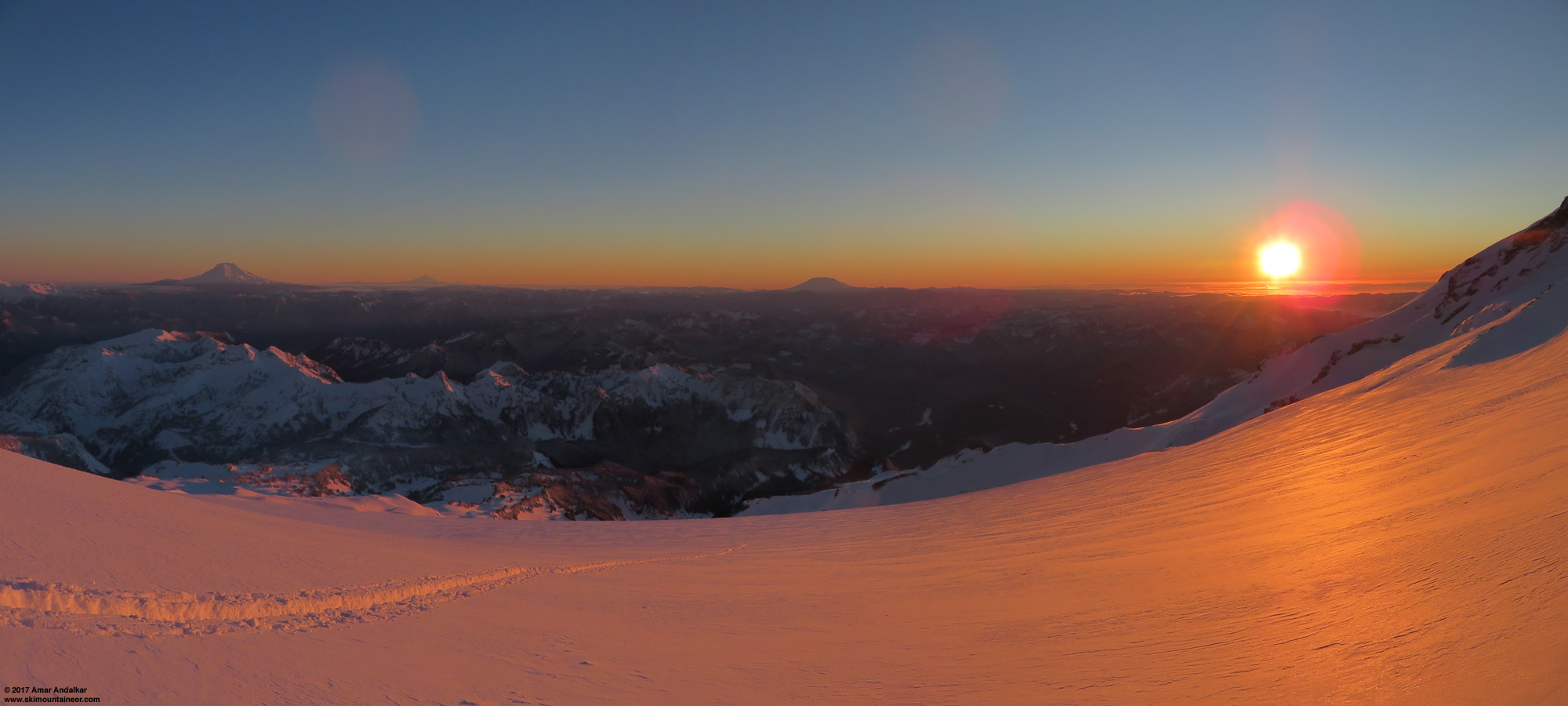
[size=small]Two-shot sunset panorama on January 12 from Camp Muir, with Mounts Adams, Hood, Jefferson, and Saint Helens on the horizon.
Very hard to see in this pic that Jefferson appears more prominent than normal. (click for double-size version)[/size]
The next day I was back for seconds, eager to reuse the skintrack emplaced at great toil the day before and also celebrate my 1000th backcountry ski day, once again solo and acquiring a ski partner in the parking lot this time. We would be the only 2 to reach Muir this Friday, as despite the excellent track already in place, no one else would follow us up there. The strange view of Jefferson the day before was in the back of my mind, and as we skinned up past 8000 ft, I was surprised to look back and see Jefferson already clearly visible, far earlier and lower down than it can normally be seen while ascending to Muir. Upon reaching Camp Muir, it was plainly obvious that something was very strange indeed about the view: Mount Jefferson appeared to be far taller than it normally is, perhaps thousands of feet taller. My ski partner, a veteran of numerous Muir trips and Rainier summits over the past 3-4 decades (plus a number of very difficult summits in Alaska including Mounts Foraker and Saint Elias), agreed that Jefferson looked strangely tall indeed. What on earth was going on?
Well, obviously the answer is already in the title of this post. A superior mirage occurs when the air below the line of sight is colder than the air above it, as happens during a temperature inversion, and light rays passing through the air are bent downwards by the lower index of refraction of the warmer air above. Thus distant objects appear to be higher in the sky than they actually are, and if the image is undistorted and non-inverted, the effect is referred to as "looming". This increases the apparent elevation of distant objects such as mountains, and can allow one to see objects which are normally hidden beyond the horizon or below intervening objects (such as closer ridges or mountains). Here is a decent diagram of the effect from Wikimedia Commons:
https://upload.wikimedia.org/wikipedia/commons/5/54/Superior_and_inferior_mirage.svg
Recent weather conditions have allowed very large, even extreme, temperature inversions to develop along much of the terrain near the Cascade Crest and just east of it in both Washington and Oregon (as shown in the telemetry data at the end of this post). This has provided just the right conditions to give Oregon the appearance of having two 12000 ft peaks!
With no time pressure the second day, I made sure to take several photos at various levels of zoom, to document Jefferson's strange appearance. But a shield of high clouds had moved in during the day, much thicker and darker than expected based on the Rainier forecast and the UW model (although the model did at least predict the high clouds). I was saddened that my pics of Hood and Jefferson would not be sunny ones this day, but the high clouds actually turned out to be a blessing in disguise. Wintertime pics of Hood and Jefferson seen from Rainier are always deeply shadowed on clear sunny days, rendering most details invisible, while the diffusing effect of the thick high clouds ironically allowed much better visibility of the glaciers and other features on the north faces of those peaks.
Here is the view of Hood and Jefferson from Camp Muir on January 13, 2017, taken with a Canon SX720 HS partially-zoomed to an equivalent focal length of 240 mm:
[size=small]View on January 13 from Camp Muir, looking south at Mounts Hood and Jefferson. (click for double-size version)[/size]
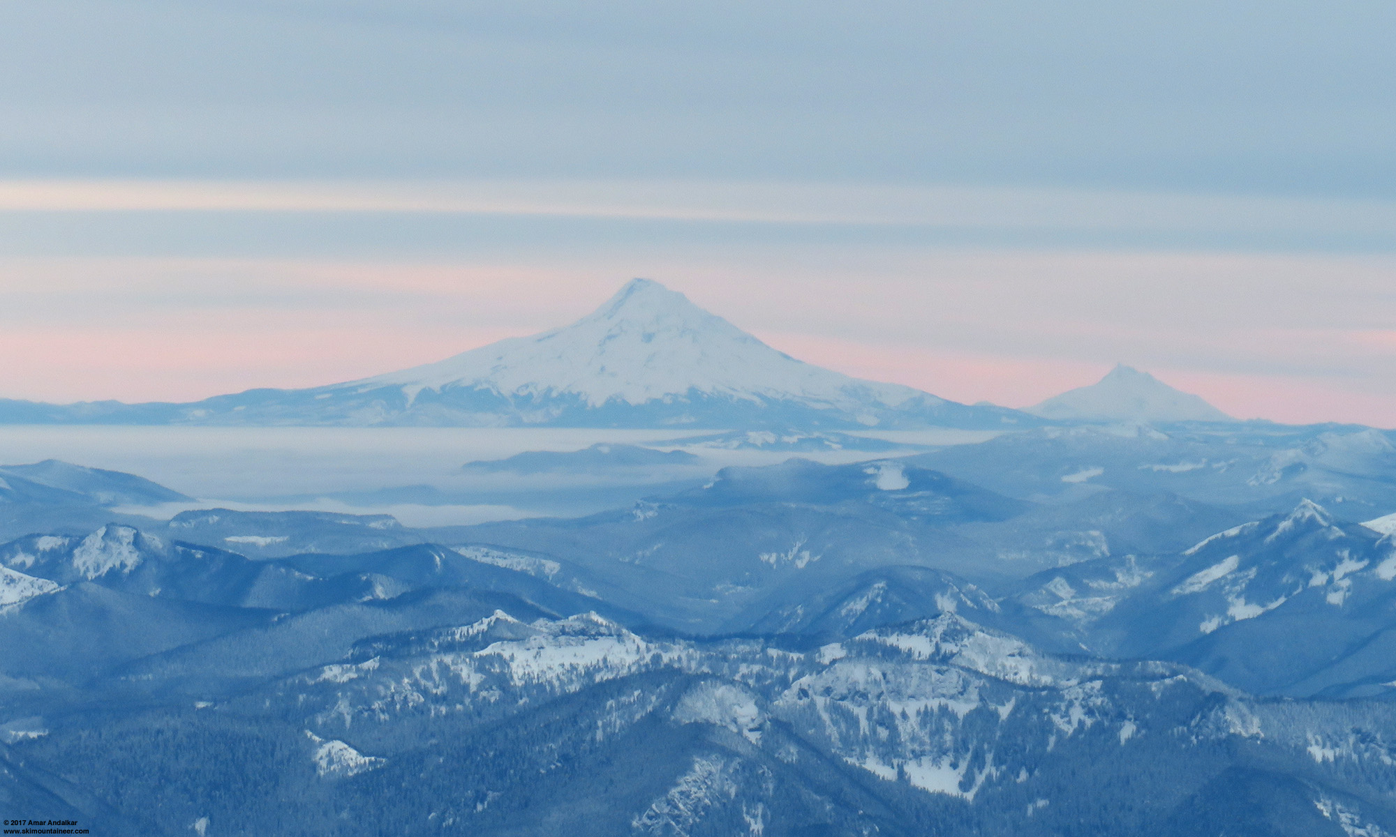
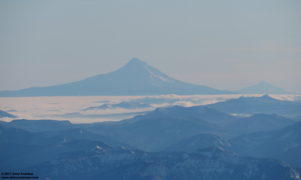
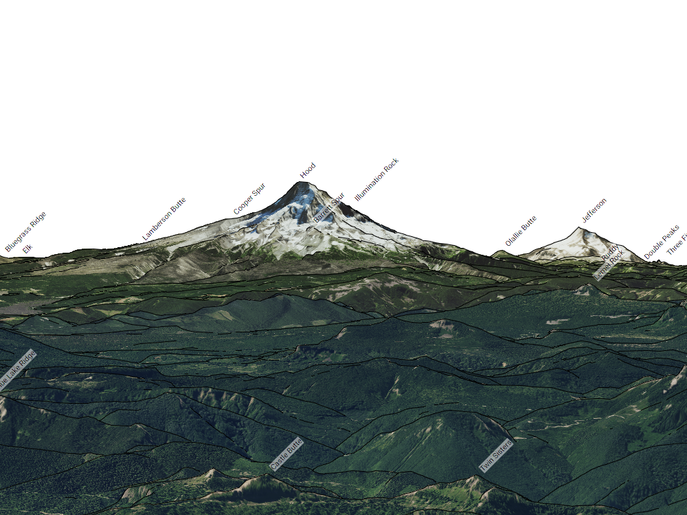
This image shows not only a view which extends much lower down the north slopes of these volcanoes than normal, but also reveals an unexpected interloper between Hood and Jefferson which is normally never seen from Camp Muir. The interloper is Olallie Butte, a 7215 ft shield volcano which is the highest point in the 50-mile span between Hood and Jefferson.
This fully-zoomed view with an equivalent focal length of 960 mm shows Olallie Butte at left poking above the flanks of Hood, along with most of the north face of Jefferson extending down past the termini of the Jefferson Park and Russell Glaciers (center and right) and nearly down to the terminus of the northern lobe of Whitewater Glacier (left center):
The next day I was back again for a third trip to Muir, this time with Khanh and Michelle as partners, and joined by dozens of others too given that it was a sunny Saturday. Crystal clear skies again like Thursday, and Jefferson was once again much more prominent than normal. However, the clear skies made conditions much worse for photos of Hood and Jefferson, with details of their north faces completely lost in the shadows as seen here with an equivalent focal length of 68 mm:
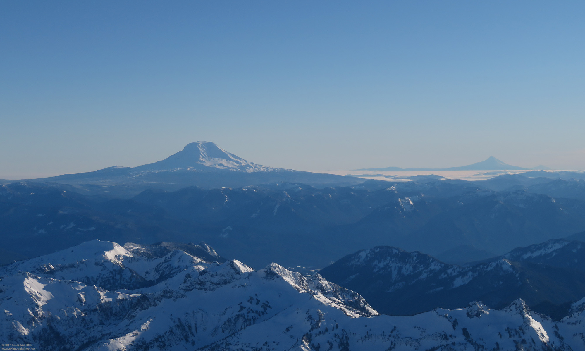
[size=small]View on January 14 from Camp Muir, looking south at Mounts Adams, Hood, and Jefferson. (click for double-size version)[/size]
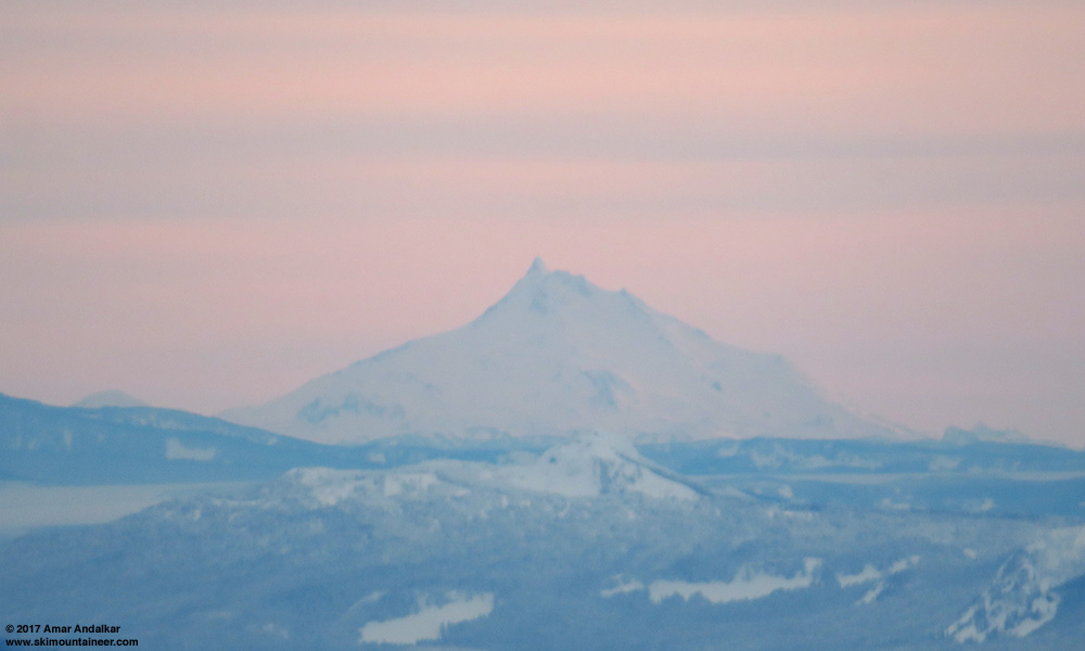
This partially-zoomed view with an equivalent focal length of 370 mm shows Olallie Butte once again rising above the flanks of Mount Hood:
So how does one figure out that Mounts Jefferson and Hood appeared to be over 12000 ft high on these days?
CalTopo provides an excellent tool for simulating the view from any location, and its "WireImagery" setting gives an edge-enhanced, photo-realistic view. Here is the CalTopo simulation of the normal view looking due south from 9000 ft on the Muir Snowfield, with the summit of Mount Jefferson just barely becoming visible above the intervening peak of 5925 ft Lemei Rock, highest point of the massive Indian Heaven volcanic field in southern Washington:
caltopo.com/view#ll=46.8255,-121.7323&e=6&t=,n&z=8&c=-0.64,180
And the normal very familiar view from Camp Muir at 10100 ft, looking due south, with Hood and Jefferson appearing as they normally do:
caltopo.com/view#ll=46.8355,-121.7323&e=6&t=,n&z=8&c=-0.75,180
Here is the CalTopo simulation of the same view, but from a point located 1000 ft directly above Camp Muir, with Olallie Butte now barely visible:
caltopo.com/view#ll=46.8355,-121.7323&e=...t=,n&z=8&c=-0.85,180
And the same view from a point located 2500 ft directly above Camp Muir, with Olallie Butte now clearly visible and Mount Jefferson extending almost twice as high above the horizon as it normally does from Camp Muir:
caltopo.com/view#ll=46.8355,-121.7323&e=762&t=,n&z=8&c=-1,180
This GIF animation combines all 4 of those simulated views, to easily visualize the changes as a function of increasing elevation of the viewpoint (9000, 10100, 11100, and 12600 ft). The view of Mount Hood changes only subtly as seen on its lower flanks, but Mount Jefferson rises up dramatically from the horizon:

The last simulated view provides the closest match to the 2 zoomed images above from January 13 and 14, although a point about 2000 ft above Muir would provide an even better match than 2500 ft does. (For some reason, CalTopo does not let you pick arbitrary values for that vertical offset, even by manually editing the URL, so you're stuck using its preprogrammed values.) Given the reversibility of the optical physics along a line of sight, the view of distant objects from a point 2000 ft higher than Camp Muir is the same as the view from Muir of those same distant objects if they were raised by 2000 ft. So it's as though Mount Jefferson were appearing about 2000 ft higher than it really is, as if it were well over 12000 ft high. And careful inspection of these images reveals that Mount Hood also appears much higher than it actually is, well over 1000 ft higher and thus also easily exceeding 12000 ft in apparent height.
With over 100 ski trips to Camp Muir during the months of November to March, I'm sure that I've been up there before during similar wintertime conditions with upper-level high pressure and a strong temperature inversion, perhaps even sometime with a stronger inversion than this week. It is highly likely that Mount Jefferson had extra prominence due to superior miraging during some of those previous trips too, but somehow I failed to notice it ever before. I'll make sure to look for it and photograph it anytime that conditions are suitable in the future.
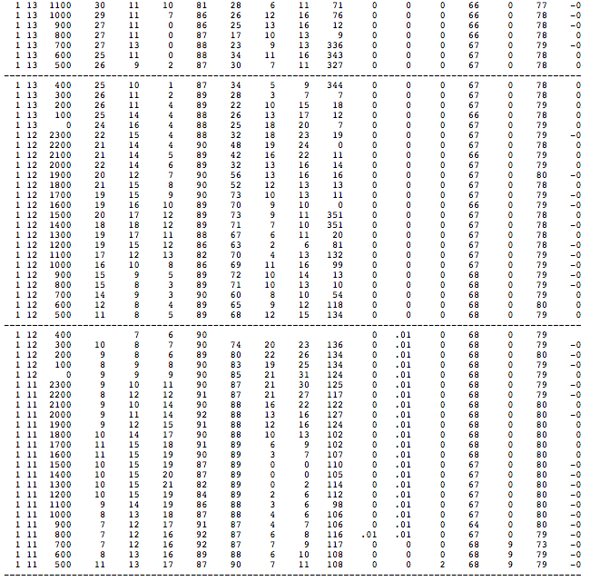
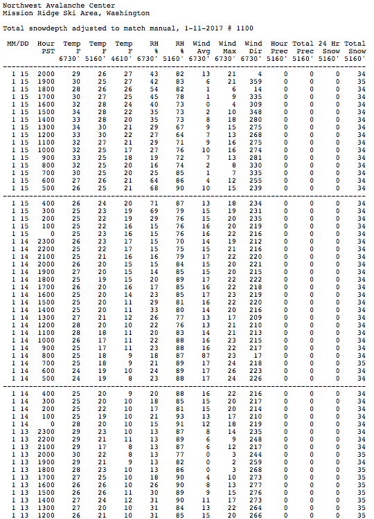
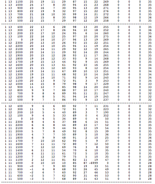
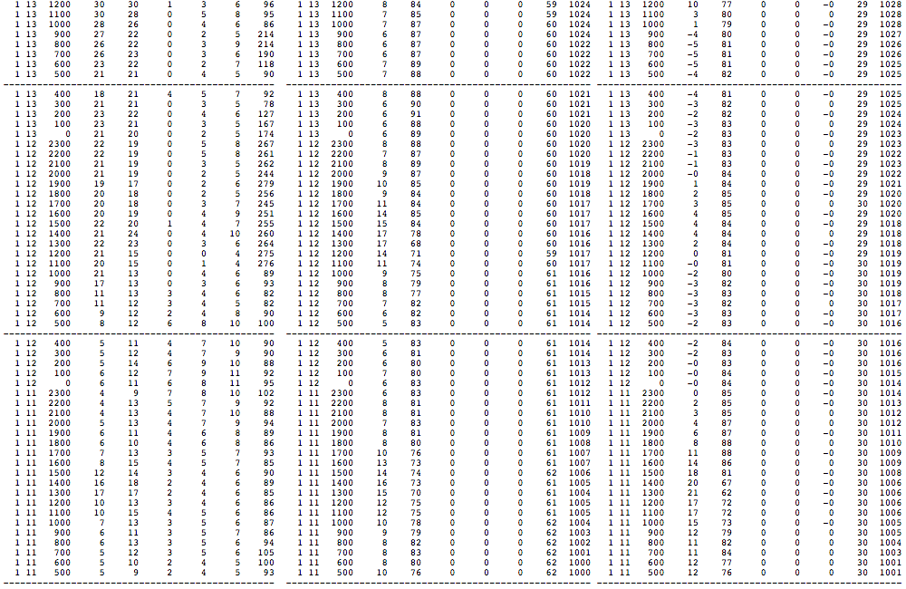
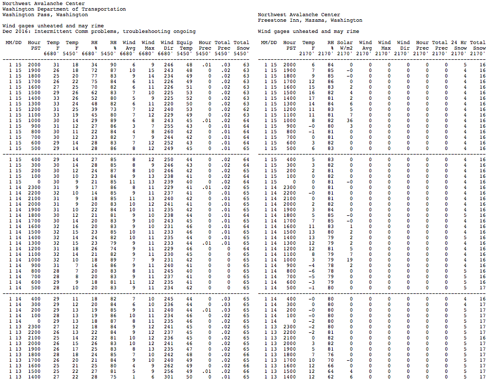
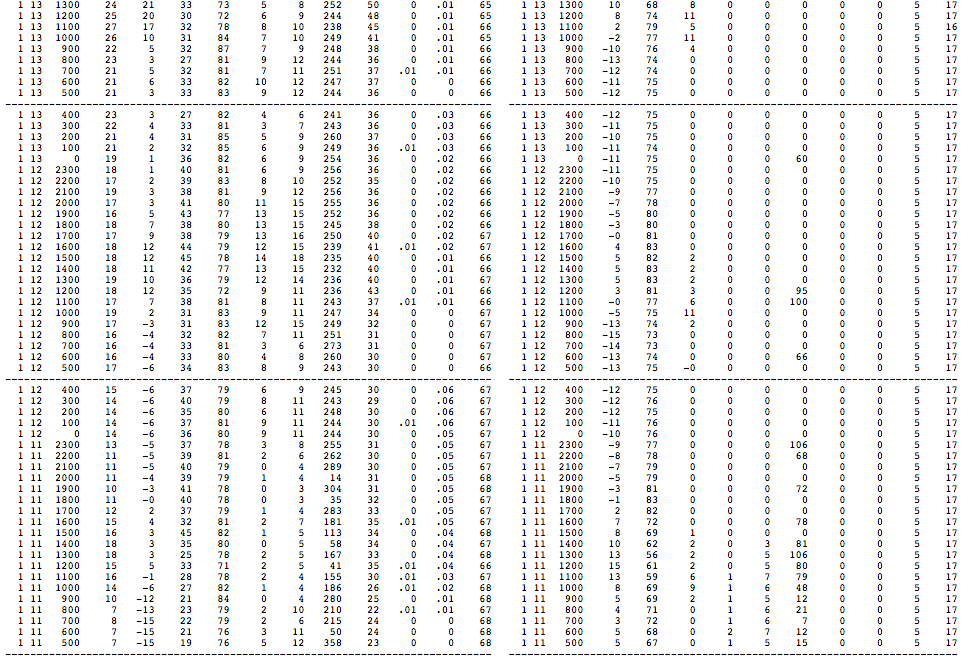
Lastly, here is some telemetry data demonstrating the very strong temperature inversion near the Cascade Crest in both Washington and Oregon which was responsible for this effect. Note that the lapse rate in the standard atmosphere is a decrease of 3.5 °F for every 1000 ft increase in elevation, so temperature increases of 10, 20, even 30 °F over a few thousand feet of elevation gain are very unusually strong inversions indeed.
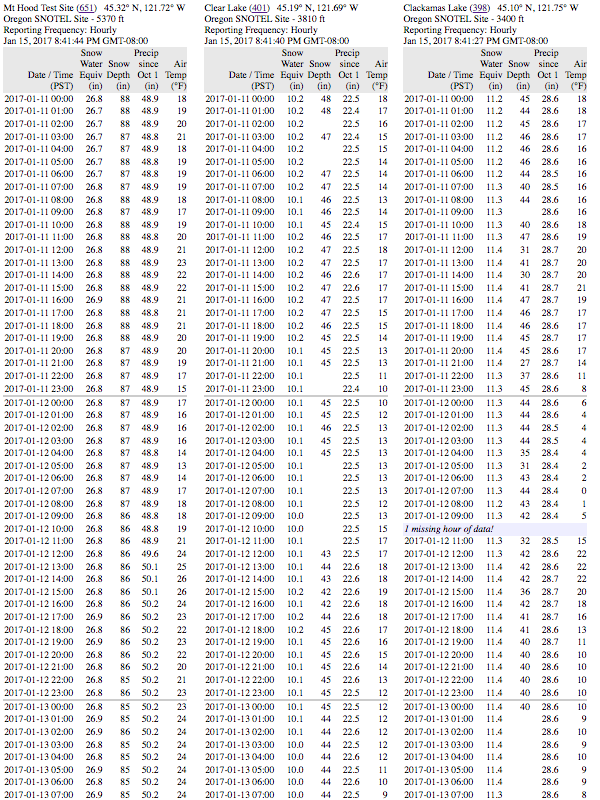
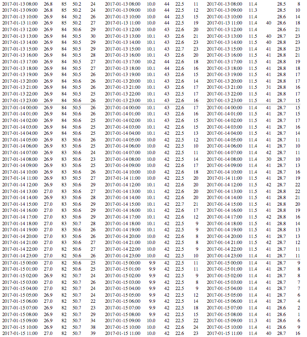
Here are 3 SNOTEL sites between Mounts Hood and Jefferson, with Mt Hood Test Site SNOTEL at 5370 ft on the south side of Mount Hood about 1 mile SSW of Timberline Lodge, Clear Lake SNOTEL at 3810 ft about 12 miles south of Mount Hood, and Clackamas Lake SNOTEL at 3400 ft about 19 miles SSW of Mount Hood. Temperatures are 10-20 °F warmer at 5370 ft on Mount Hood than at 3400 ft in the valleys to its south from January 12-15:
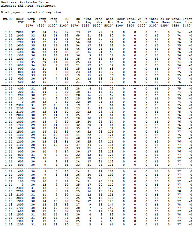
I couldn't find any good sets of vertically-stacked telemetry sites in southern Washington to demonstrate a similar inversion along more of the line of sight between Mounts Hood and Rainier. But farther north in Washington, several groups of NWAC sites which do provide vertical temperature profiles showed an even stronger inversion of 20-30 °F over those same days:

as seen from Camp Muir, January 12-14, 2017
Most people who are familiar with the mountains of the Pacific Northwest know that there are no 12000 ft peaks in Oregon: the highest two are 11249 ft Mount Hood, located just south of the Columbia Gorge, and 10497 ft Mount Jefferson, about 50 miles south of Hood. On clear days, both of these volcanoes are easily visible from elevations above about 9000 ft on the south side of Mount Rainier, at a distance of 102 miles to Mount Hood and 150 miles to Mount Jefferson. With nearly 300 ski trips to Camp Muir over the last 20 years, most of them on clear sunny days, this view of Hood and Jefferson has become very familiar to me. But on certain days with the right atmospheric conditions, this familiar view can take on a strangely surreal appearance, and Mounts Hood and Jefferson can appear to be much taller, well over 12000 ft high! It's hard to tell the difference at first when looking at Hood, but the change in the relative prominence of Jefferson can be rather dramatic.
I first noticed this effect on Thursday, January 12, after breaking trail up to Camp Muir through 24-30" of fresh low-density powder (!!!), by far the deepest powder I have ever encountered on the Muir Snowfield (see TR: January 12-14, 2017, Mount Rainier, Muir Snowfield x3: 2+ ft of DEEP Powder!!! ). Gazing south from Muir, something looked different about this very familiar view, and it seemed like Mount Jefferson looked unusually prominent. Even my 3 acquired ski partners (I had been solo and joined them near 6500 ft), who had been to Muir only a few times before, commented about how amazing the view of Jefferson was. But given our 4:20pm arrival at Camp Muir after hours of extremely arduous trail-breaking, I didn't think too much about it and even forgot to take a nicely zoomed in photo of Jefferson as we quickly transitioned, then skied down in the almost unskiably-deep powder just before sunset.
[size=small]Two-shot sunset panorama on January 12 from Camp Muir, with Mounts Adams, Hood, Jefferson, and Saint Helens on the horizon.
Very hard to see in this pic that Jefferson appears more prominent than normal. (click for double-size version)[/size]
The next day I was back for seconds, eager to reuse the skintrack emplaced at great toil the day before and also celebrate my 1000th backcountry ski day, once again solo and acquiring a ski partner in the parking lot this time. We would be the only 2 to reach Muir this Friday, as despite the excellent track already in place, no one else would follow us up there. The strange view of Jefferson the day before was in the back of my mind, and as we skinned up past 8000 ft, I was surprised to look back and see Jefferson already clearly visible, far earlier and lower down than it can normally be seen while ascending to Muir. Upon reaching Camp Muir, it was plainly obvious that something was very strange indeed about the view: Mount Jefferson appeared to be far taller than it normally is, perhaps thousands of feet taller. My ski partner, a veteran of numerous Muir trips and Rainier summits over the past 3-4 decades (plus a number of very difficult summits in Alaska including Mounts Foraker and Saint Elias), agreed that Jefferson looked strangely tall indeed. What on earth was going on?
Well, obviously the answer is already in the title of this post. A superior mirage occurs when the air below the line of sight is colder than the air above it, as happens during a temperature inversion, and light rays passing through the air are bent downwards by the lower index of refraction of the warmer air above. Thus distant objects appear to be higher in the sky than they actually are, and if the image is undistorted and non-inverted, the effect is referred to as "looming". This increases the apparent elevation of distant objects such as mountains, and can allow one to see objects which are normally hidden beyond the horizon or below intervening objects (such as closer ridges or mountains). Here is a decent diagram of the effect from Wikimedia Commons:
https://upload.wikimedia.org/wikipedia/commons/5/54/Superior_and_inferior_mirage.svg
Recent weather conditions have allowed very large, even extreme, temperature inversions to develop along much of the terrain near the Cascade Crest and just east of it in both Washington and Oregon (as shown in the telemetry data at the end of this post). This has provided just the right conditions to give Oregon the appearance of having two 12000 ft peaks!
With no time pressure the second day, I made sure to take several photos at various levels of zoom, to document Jefferson's strange appearance. But a shield of high clouds had moved in during the day, much thicker and darker than expected based on the Rainier forecast and the UW model (although the model did at least predict the high clouds). I was saddened that my pics of Hood and Jefferson would not be sunny ones this day, but the high clouds actually turned out to be a blessing in disguise. Wintertime pics of Hood and Jefferson seen from Rainier are always deeply shadowed on clear sunny days, rendering most details invisible, while the diffusing effect of the thick high clouds ironically allowed much better visibility of the glaciers and other features on the north faces of those peaks.
Here is the view of Hood and Jefferson from Camp Muir on January 13, 2017, taken with a Canon SX720 HS partially-zoomed to an equivalent focal length of 240 mm:
[size=small]View on January 13 from Camp Muir, looking south at Mounts Hood and Jefferson. (click for double-size version)[/size]
This image shows not only a view which extends much lower down the north slopes of these volcanoes than normal, but also reveals an unexpected interloper between Hood and Jefferson which is normally never seen from Camp Muir. The interloper is Olallie Butte, a 7215 ft shield volcano which is the highest point in the 50-mile span between Hood and Jefferson.
This fully-zoomed view with an equivalent focal length of 960 mm shows Olallie Butte at left poking above the flanks of Hood, along with most of the north face of Jefferson extending down past the termini of the Jefferson Park and Russell Glaciers (center and right) and nearly down to the terminus of the northern lobe of Whitewater Glacier (left center):
The next day I was back again for a third trip to Muir, this time with Khanh and Michelle as partners, and joined by dozens of others too given that it was a sunny Saturday. Crystal clear skies again like Thursday, and Jefferson was once again much more prominent than normal. However, the clear skies made conditions much worse for photos of Hood and Jefferson, with details of their north faces completely lost in the shadows as seen here with an equivalent focal length of 68 mm:
[size=small]View on January 14 from Camp Muir, looking south at Mounts Adams, Hood, and Jefferson. (click for double-size version)[/size]
This partially-zoomed view with an equivalent focal length of 370 mm shows Olallie Butte once again rising above the flanks of Mount Hood:
So how does one figure out that Mounts Jefferson and Hood appeared to be over 12000 ft high on these days?
CalTopo provides an excellent tool for simulating the view from any location, and its "WireImagery" setting gives an edge-enhanced, photo-realistic view. Here is the CalTopo simulation of the normal view looking due south from 9000 ft on the Muir Snowfield, with the summit of Mount Jefferson just barely becoming visible above the intervening peak of 5925 ft Lemei Rock, highest point of the massive Indian Heaven volcanic field in southern Washington:
caltopo.com/view#ll=46.8255,-121.7323&e=6&t=,n&z=8&c=-0.64,180
And the normal very familiar view from Camp Muir at 10100 ft, looking due south, with Hood and Jefferson appearing as they normally do:
caltopo.com/view#ll=46.8355,-121.7323&e=6&t=,n&z=8&c=-0.75,180
Here is the CalTopo simulation of the same view, but from a point located 1000 ft directly above Camp Muir, with Olallie Butte now barely visible:
caltopo.com/view#ll=46.8355,-121.7323&e=...t=,n&z=8&c=-0.85,180
And the same view from a point located 2500 ft directly above Camp Muir, with Olallie Butte now clearly visible and Mount Jefferson extending almost twice as high above the horizon as it normally does from Camp Muir:
caltopo.com/view#ll=46.8355,-121.7323&e=762&t=,n&z=8&c=-1,180
This GIF animation combines all 4 of those simulated views, to easily visualize the changes as a function of increasing elevation of the viewpoint (9000, 10100, 11100, and 12600 ft). The view of Mount Hood changes only subtly as seen on its lower flanks, but Mount Jefferson rises up dramatically from the horizon:
The last simulated view provides the closest match to the 2 zoomed images above from January 13 and 14, although a point about 2000 ft above Muir would provide an even better match than 2500 ft does. (For some reason, CalTopo does not let you pick arbitrary values for that vertical offset, even by manually editing the URL, so you're stuck using its preprogrammed values.) Given the reversibility of the optical physics along a line of sight, the view of distant objects from a point 2000 ft higher than Camp Muir is the same as the view from Muir of those same distant objects if they were raised by 2000 ft. So it's as though Mount Jefferson were appearing about 2000 ft higher than it really is, as if it were well over 12000 ft high. And careful inspection of these images reveals that Mount Hood also appears much higher than it actually is, well over 1000 ft higher and thus also easily exceeding 12000 ft in apparent height.
With over 100 ski trips to Camp Muir during the months of November to March, I'm sure that I've been up there before during similar wintertime conditions with upper-level high pressure and a strong temperature inversion, perhaps even sometime with a stronger inversion than this week. It is highly likely that Mount Jefferson had extra prominence due to superior miraging during some of those previous trips too, but somehow I failed to notice it ever before. I'll make sure to look for it and photograph it anytime that conditions are suitable in the future.
Lastly, here is some telemetry data demonstrating the very strong temperature inversion near the Cascade Crest in both Washington and Oregon which was responsible for this effect. Note that the lapse rate in the standard atmosphere is a decrease of 3.5 °F for every 1000 ft increase in elevation, so temperature increases of 10, 20, even 30 °F over a few thousand feet of elevation gain are very unusually strong inversions indeed.
Here are 3 SNOTEL sites between Mounts Hood and Jefferson, with Mt Hood Test Site SNOTEL at 5370 ft on the south side of Mount Hood about 1 mile SSW of Timberline Lodge, Clear Lake SNOTEL at 3810 ft about 12 miles south of Mount Hood, and Clackamas Lake SNOTEL at 3400 ft about 19 miles SSW of Mount Hood. Temperatures are 10-20 °F warmer at 5370 ft on Mount Hood than at 3400 ft in the valleys to its south from January 12-15:
I couldn't find any good sets of vertically-stacked telemetry sites in southern Washington to demonstrate a similar inversion along more of the line of sight between Mounts Hood and Rainier. But farther north in Washington, several groups of NWAC sites which do provide vertical temperature profiles showed an even stronger inversion of 20-30 °F over those same days:
Please Log in or Create an account to join the conversation.
- davidG
- [davidG]
-
- Offline
- Elite Member
-

Less
More
- Posts: 764
- Thank you received: 0
16 Jan 2017 09:23 #228314
by davidG
Replied by davidG on topic Re: Strong temp inversion, 12000ft Mt Jefferson mirage
Cool! Always wondered about that mechanism when sometimes Baker seems larger than it 'should', when viewed from various places in the Cascades. Also wonder about the 'math' when objects like Rainier seem particularly large or small when viewed from relatively nearby. Explanation forthcoming..? ")
Please Log in or Create an account to join the conversation.
- haggis
- [haggis]
-
- Offline
- Senior Member
-

Less
More
- Posts: 255
- Thank you received: 0
16 Jan 2017 09:37 #228315
by haggis
Replied by haggis on topic Re: Strong temp inversion, 12000ft Mt Jefferson mirage
I noticed the shimmering "mirage" just above the inversion layer recently too with the huge temperature difference. In some cases it was 0F at the base of Alpental and 30F at the top which is truly amazing.
Please Log in or Create an account to join the conversation.
- jilldabeast
- [jillyo]
-
- Offline
- New Member
-

Less
More
- Posts: 1
- Thank you received: 0
16 Jan 2017 10:35 #228316
by jilldabeast
Replied by jilldabeast on topic Re: Strong temp inversion, 12000ft Mt Jefferson mirage
Thanks for your thorough explanation, Amar. Almost feels like I was there with you (minus the stellar downhill part)!
Please Log in or Create an account to join the conversation.
- Micah
- [primate]
-
- Offline
- Moderator
-

Less
More
- Posts: 142
- Thank you received: 0
16 Jan 2017 10:49 #228317
by Micah
Replied by Micah on topic Re: Strong temp inversion, 12000ft Mt Jefferson mirage
Very nice investigation of a fascinating phenomenon! I've played 'name that peak' many times, but it hadn't occurred to me that atmospheric optical effects could materially affect which peaks are visible from a given vantage. Thanks, Amar.
Please Log in or Create an account to join the conversation.
- Martin Mudry
- [Martin Mudry]
-
- Offline
- New Member
-
Less
More
- Posts: 6
- Thank you received: 0
20 Feb 2017 19:19 #228888
by Martin Mudry
Replied by Martin Mudry on topic Re: Strong temp inversion, 12000ft Mt Jefferson mirage
Beautiful pictures and awesome write up + examples!
Please Log in or Create an account to join the conversation.
- swaterfall
- [swaterfall]
-
- Offline
- New Member
-
Less
More
- Posts: 45
- Thank you received: 0
21 Feb 2017 14:39 #228898
by swaterfall
Replied by swaterfall on topic Re: Strong temp inversion, 12000ft Mt Jefferson mirage
Really, really cool post Amar. Thanks!
Please Log in or Create an account to join the conversation.
- rahove
- [h-monster]
-
- Offline
- New Member
-
Less
More
- Posts: 1
- Thank you received: 0
23 Feb 2017 23:03 #228924
by rahove
Replied by rahove on topic Re: Strong temp inversion, 12000ft Mt Jefferson mirage
Thanks for this post--really thoughtful and meticulous, and beautiful shots. I'm going to watch for this!
Please Log in or Create an account to join the conversation.