- Posts: 635
- Thank you received: 0
10-20 ft Snowfall Predicted for CA, 02-13Jan2017!!
- Amar Andalkar
- [andalkar]
-
 Topic Author
- Offline
- Premium Member
-

Less
More
04 Jan 2017 03:47 - 04 Jan 2017 14:51 #228091
by Amar Andalkar
10-20 ft Snowfall Predicted for CA, 02-13Jan2017!! was created by Amar Andalkar
10-20 ft of Snowfall Currently Predicted for California Cascades and Sierra Nevada over the 11-Day Period from January 2-13, 2017!!!
It looks like the New Year of 2017 will start off with quite a bang for skiers in California: weather models are currently predicting over 10-15" of precipitation for much of the Sierra Nevada plus the highest volcanoes in the California Cascades (Mount Shasta and Lassen Peak) during the 11-day period from January 2-13, with maximum precip amounts of up to 25-30" in parts of the Sierra Nevada. Over the last week, weather models have been hinting at a sustained period of very heavy precip and snowfall for California during the first 1-2 weeks of January, and those predictions have now solidified into the National Weather Service's official forecasts. A series of 3 atmospheric river events will feed massive amounts of precip on the West Coast, each aimed primarily into California.
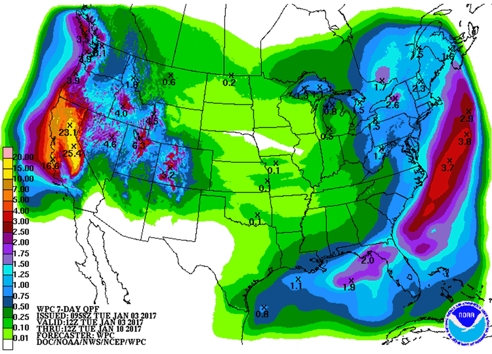
Moderate precip and snowfall began in the northernmost part of the state on January 1 over the coastal Klamath Mountains, extending into the California Cascades and northern Sierra Nevada on January 2 with precip amounts up to 1" and snowfall up to 1 ft, but the really heavy action began on January 3. Here is predicted precip over the 7-day period from 4am January 3 to January 10:
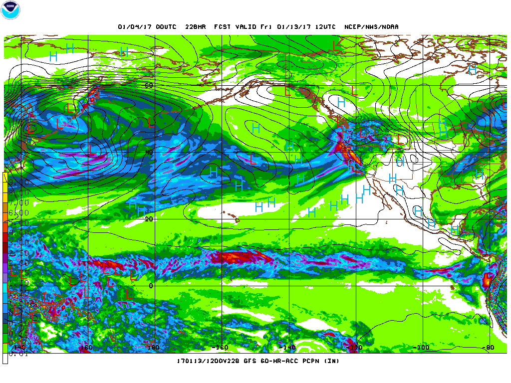
For the period after that, the extended 16-day run of the GFS model shows an additional 5-7" of precip for the Sierra over the next 3 days through 4am January 13, after which the storm cycle is currently expected to peter out (although that could change, 10 days out is a very long time in the world of numerical weather models):
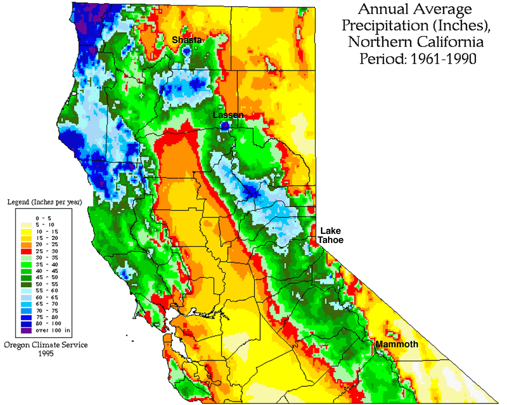
Amazingly, that 7-day precip amount of 25" in the south-central Sierra (not even counting 5-7" more over the next 3 days) is equal to about HALF of the average annual precipitation in that area, which is about 50-60" per year:
So this will truly be an exceptional deluge of precipitation for most of the Sierra!
The mountains in all of these areas of the California Cascades and Sierra Nevada extend far above the predicted snow levels during this period, so the extremely heavy precip will be entirely in the form of snowfall at the mid-to-upper elevations (above 5000 ft in the California Cascades and above 6000-9000 ft along the length of the Sierra from north to south). Snowfall amounts are thus expected to be in excess of 10 ft through January 13 over large areas of the Sierra and on Shasta and Lassen, with perhaps as much as 20 ft (or more?) possible in the most favored areas of the Sierra if the current predictions verify.
Initially, during the first system of the storm cycle on January 2-5, snow levels are very low by California standards, as low as 1000-2000 ft in the north, so heavy snowfall of over a foot is extending far down the west slopes towards the foothills. The subsequent much wetter systems from January 7 onward will have much high snow levels according to current forecasts.
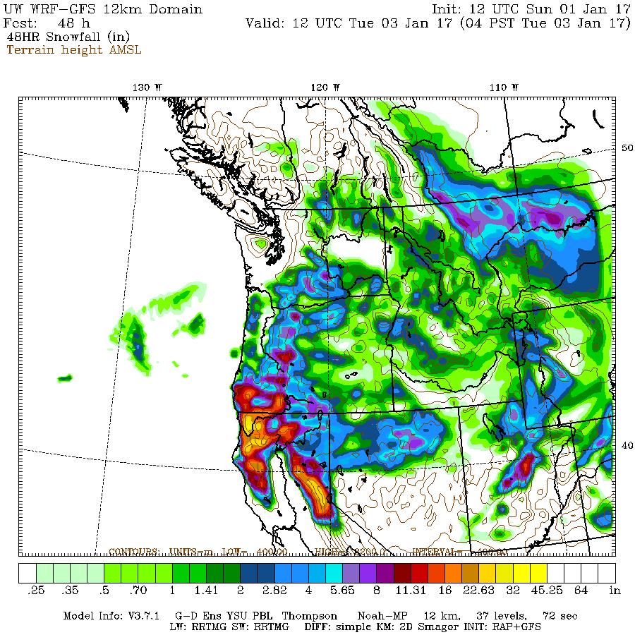
Here is the 2-day predicted snowfall from the UW WRF-GFS weather model starting from the morning of January 1, showing 1-3 ft already in some areas by 4am January 3:
Here is the 3-day predicted snowfall starting from the morning of January 3 through 4am January 6, with over 4 ft for much of the Sierra Nevada, with 1-3 ft in the California Cascades:

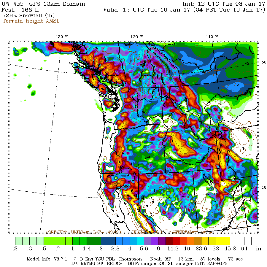
There's expected to be a gap between storm systems on Friday January 6, and then the next much stronger and wetter system arrives by the weekend, fueled by a second even more potent atmospheric river. Here is the 3-day predicted snowfall starting from the morning of January 7 through 4am January 10, with another 4+ ft for much of the Sierra Nevada, with 2-4 ft in the California Cascades, and 1-3 ft extending north throughout the length of the Oregon and Washington Cascades and into the Olympics and southwestern BC:
Snowfall predictions from these models are not available past 7 days out, so the precip graphic above will have to suffice for now for the January 10-13 period.
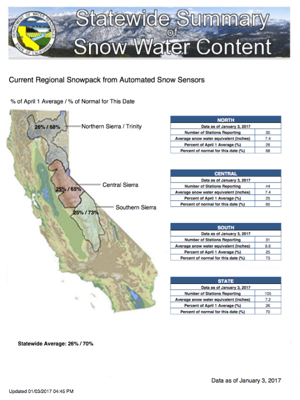
So what does the snowpack in California and the western United States look like as of the New Year prior to this storm cycle? The early season snowpack so far has been substantially below normal throughout California, with the exception of high elevations on Mount Shasta (above 8000 ft, above any snow measurement sites) that built a deep snowpack during the very wet month of October, catching the southern edge of the record-shattering October precip which hit the Pacific Northwest. As of January 3 (there was a data outage from December 30 through January 2), the snowpack throughout the Klamath Mountains, California Cascades, and Sierra Nevada was only about 70% of normal for that date (map from cdec.water.ca.gov/snow/current/snow/):
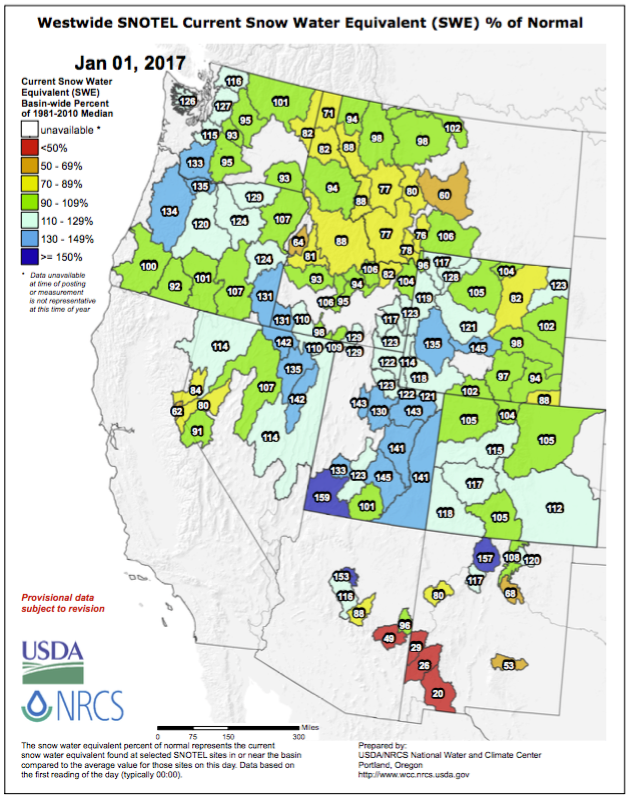
This is in sharp contrast to most other regions of the western United States, which in general have normal to above-normal snowpack (except southern Arizona and New Mexico). California has its own state-run snow survey program unlike all other states (except for basins near Lake Tahoe which flow into Nevada), so unfortunately their data does not appear on the NRCS SNOTEL maps (these maps including a full daily archive back to 2010 are at www.wcc.nrcs.usda.gov/ftpref/data/water/wcs/gis/maps/):
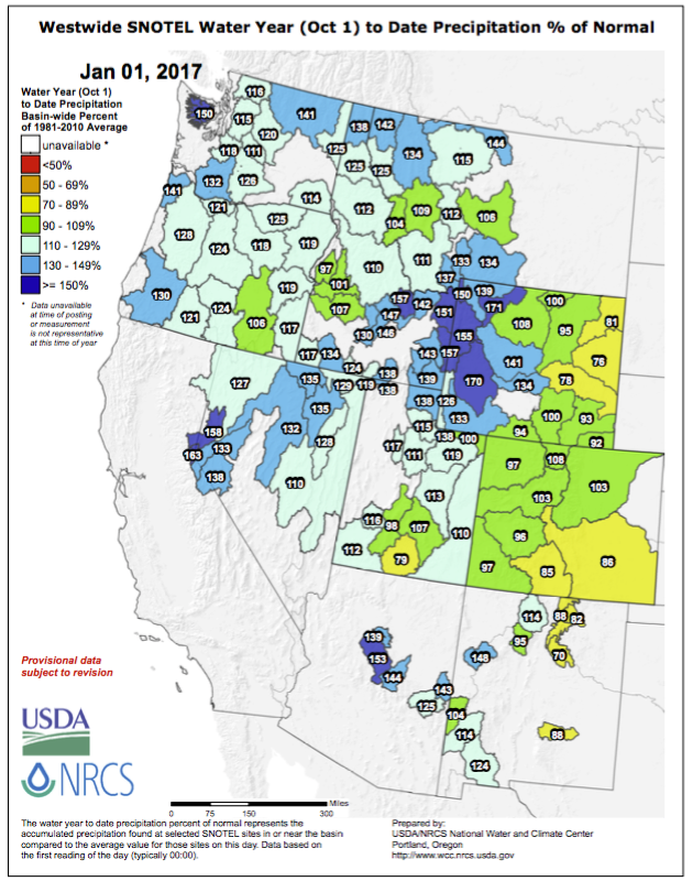
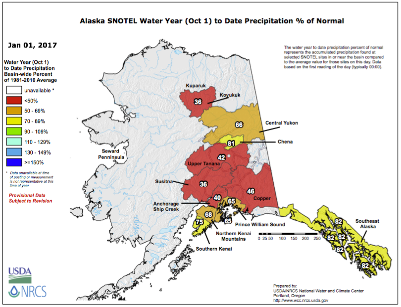
Precipitation for this water year since October 1 has also been above-normal throughout most of the western United States, with the exception eastern side of the Rockies which are somewhat below-normal:
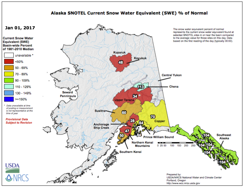
Alaska is doing about as poorly as California, and even much worse in some regions, as both snowpack and precip have been well below-normal except in the southeastern panhandle. There's no help at all on the way for them yet, as current forecasts over the next 2 weeks look very dry up there:
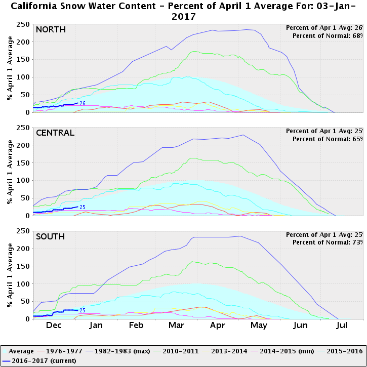
So going back to California: what does this season's below-normal snowpack so far look like compared to the last several years and historical record values? This plot shows overall snowpack for the same 3 regions as the "Statewide Summary of Snow Water Content" map shown above, with several notable seasons included: last year 2015-16 was below-normal but at least in the ballpark of normal, unlike the previous 4 drought years which were far below-normal, capped by 2013-14 which matched the previous record lows of 1976-77, and then 2014-15 which shattered those record lows completely. The last above-normal snowpack in California was 6 seasons ago in 2010-2011, which was a strong La Nina and a huge snow year throughout the western United States.
Over the next 10 days of this extremely wet and snowy storm cycle, it is almost certain that this year's plot lines will turn sharply upward, and that the California snowpack will be far above-normal by mid-January. But in order to actually end up above normal by April 1 when the major accumulation season ends, there will need to be several more storm cycles of at least moderate strength throughout the next 2-3 months.
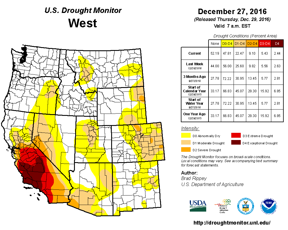
The multi-year drought in all but the northernmost part of California is still ongoing, with extreme and exceptional drought over much of the southern half (see droughtmonitor.unl.edu/MapsAndData/MapArchive.aspx):
But at least the situation has improved remarkably in the northernmost part of California over the last year, along with all of Washington and most of Oregon. Here is what the drought situation looked like only 15 months ago at the start of the 2015-16 water year:
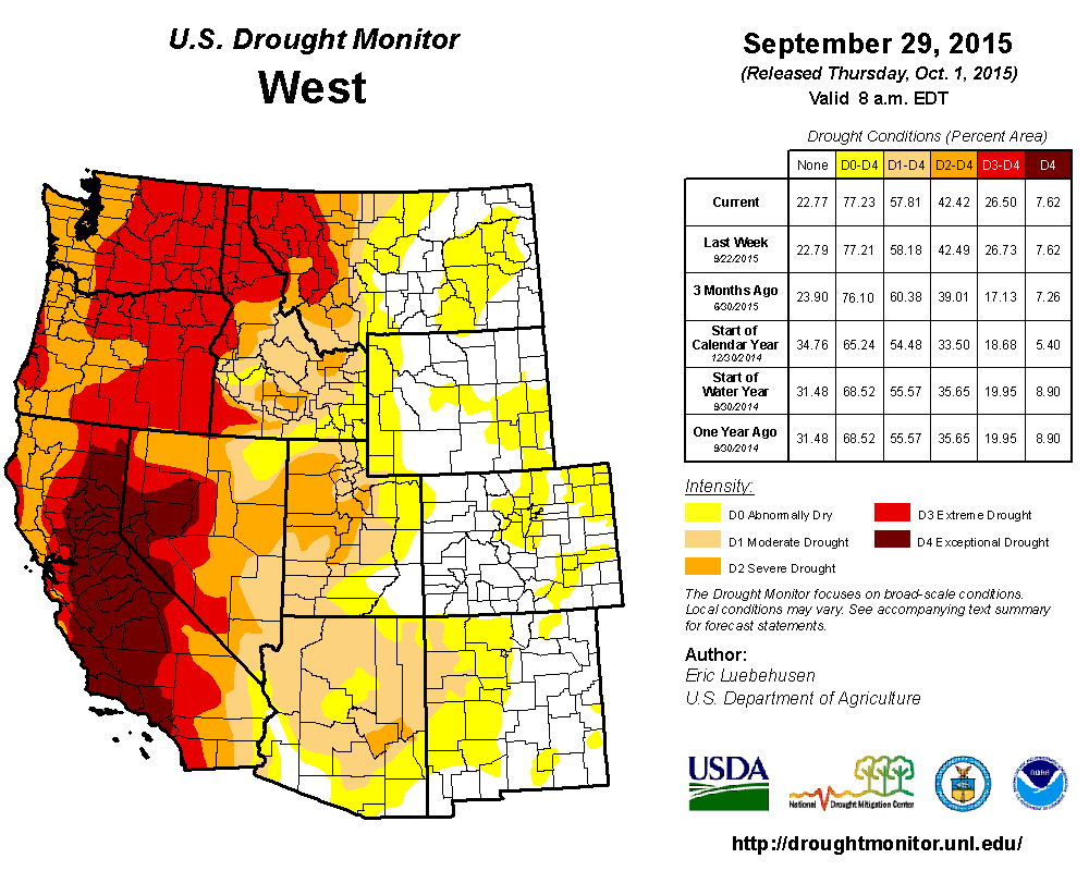
So the 20-30" of expected precip over much of the Sierra should make a substantial dent in the remaining areas of drought. it will be interesting to compare the updated plots of both snowpack and drought about 2 weeks from now.
It looks like the New Year of 2017 will start off with quite a bang for skiers in California: weather models are currently predicting over 10-15" of precipitation for much of the Sierra Nevada plus the highest volcanoes in the California Cascades (Mount Shasta and Lassen Peak) during the 11-day period from January 2-13, with maximum precip amounts of up to 25-30" in parts of the Sierra Nevada. Over the last week, weather models have been hinting at a sustained period of very heavy precip and snowfall for California during the first 1-2 weeks of January, and those predictions have now solidified into the National Weather Service's official forecasts. A series of 3 atmospheric river events will feed massive amounts of precip on the West Coast, each aimed primarily into California.
Moderate precip and snowfall began in the northernmost part of the state on January 1 over the coastal Klamath Mountains, extending into the California Cascades and northern Sierra Nevada on January 2 with precip amounts up to 1" and snowfall up to 1 ft, but the really heavy action began on January 3. Here is predicted precip over the 7-day period from 4am January 3 to January 10:
For the period after that, the extended 16-day run of the GFS model shows an additional 5-7" of precip for the Sierra over the next 3 days through 4am January 13, after which the storm cycle is currently expected to peter out (although that could change, 10 days out is a very long time in the world of numerical weather models):
Amazingly, that 7-day precip amount of 25" in the south-central Sierra (not even counting 5-7" more over the next 3 days) is equal to about HALF of the average annual precipitation in that area, which is about 50-60" per year:
So this will truly be an exceptional deluge of precipitation for most of the Sierra!
The mountains in all of these areas of the California Cascades and Sierra Nevada extend far above the predicted snow levels during this period, so the extremely heavy precip will be entirely in the form of snowfall at the mid-to-upper elevations (above 5000 ft in the California Cascades and above 6000-9000 ft along the length of the Sierra from north to south). Snowfall amounts are thus expected to be in excess of 10 ft through January 13 over large areas of the Sierra and on Shasta and Lassen, with perhaps as much as 20 ft (or more?) possible in the most favored areas of the Sierra if the current predictions verify.
Initially, during the first system of the storm cycle on January 2-5, snow levels are very low by California standards, as low as 1000-2000 ft in the north, so heavy snowfall of over a foot is extending far down the west slopes towards the foothills. The subsequent much wetter systems from January 7 onward will have much high snow levels according to current forecasts.
Here is the 2-day predicted snowfall from the UW WRF-GFS weather model starting from the morning of January 1, showing 1-3 ft already in some areas by 4am January 3:
Here is the 3-day predicted snowfall starting from the morning of January 3 through 4am January 6, with over 4 ft for much of the Sierra Nevada, with 1-3 ft in the California Cascades:
There's expected to be a gap between storm systems on Friday January 6, and then the next much stronger and wetter system arrives by the weekend, fueled by a second even more potent atmospheric river. Here is the 3-day predicted snowfall starting from the morning of January 7 through 4am January 10, with another 4+ ft for much of the Sierra Nevada, with 2-4 ft in the California Cascades, and 1-3 ft extending north throughout the length of the Oregon and Washington Cascades and into the Olympics and southwestern BC:
Snowfall predictions from these models are not available past 7 days out, so the precip graphic above will have to suffice for now for the January 10-13 period.
So what does the snowpack in California and the western United States look like as of the New Year prior to this storm cycle? The early season snowpack so far has been substantially below normal throughout California, with the exception of high elevations on Mount Shasta (above 8000 ft, above any snow measurement sites) that built a deep snowpack during the very wet month of October, catching the southern edge of the record-shattering October precip which hit the Pacific Northwest. As of January 3 (there was a data outage from December 30 through January 2), the snowpack throughout the Klamath Mountains, California Cascades, and Sierra Nevada was only about 70% of normal for that date (map from cdec.water.ca.gov/snow/current/snow/):
This is in sharp contrast to most other regions of the western United States, which in general have normal to above-normal snowpack (except southern Arizona and New Mexico). California has its own state-run snow survey program unlike all other states (except for basins near Lake Tahoe which flow into Nevada), so unfortunately their data does not appear on the NRCS SNOTEL maps (these maps including a full daily archive back to 2010 are at www.wcc.nrcs.usda.gov/ftpref/data/water/wcs/gis/maps/):
Precipitation for this water year since October 1 has also been above-normal throughout most of the western United States, with the exception eastern side of the Rockies which are somewhat below-normal:
Alaska is doing about as poorly as California, and even much worse in some regions, as both snowpack and precip have been well below-normal except in the southeastern panhandle. There's no help at all on the way for them yet, as current forecasts over the next 2 weeks look very dry up there:
So going back to California: what does this season's below-normal snowpack so far look like compared to the last several years and historical record values? This plot shows overall snowpack for the same 3 regions as the "Statewide Summary of Snow Water Content" map shown above, with several notable seasons included: last year 2015-16 was below-normal but at least in the ballpark of normal, unlike the previous 4 drought years which were far below-normal, capped by 2013-14 which matched the previous record lows of 1976-77, and then 2014-15 which shattered those record lows completely. The last above-normal snowpack in California was 6 seasons ago in 2010-2011, which was a strong La Nina and a huge snow year throughout the western United States.
Over the next 10 days of this extremely wet and snowy storm cycle, it is almost certain that this year's plot lines will turn sharply upward, and that the California snowpack will be far above-normal by mid-January. But in order to actually end up above normal by April 1 when the major accumulation season ends, there will need to be several more storm cycles of at least moderate strength throughout the next 2-3 months.
The multi-year drought in all but the northernmost part of California is still ongoing, with extreme and exceptional drought over much of the southern half (see droughtmonitor.unl.edu/MapsAndData/MapArchive.aspx):
But at least the situation has improved remarkably in the northernmost part of California over the last year, along with all of Washington and most of Oregon. Here is what the drought situation looked like only 15 months ago at the start of the 2015-16 water year:
So the 20-30" of expected precip over much of the Sierra should make a substantial dent in the remaining areas of drought. it will be interesting to compare the updated plots of both snowpack and drought about 2 weeks from now.
Please Log in or Create an account to join the conversation.
- MattT
- [MattT]
-
- Offline
- Junior Member
-

Less
More
- Posts: 62
- Thank you received: 0
04 Jan 2017 11:57 #228125
by MattT
Replied by MattT on topic Re: 10-20 ft Snowfall Predicted for CA, 02-13Jan2017!!
Stoked to see Amar's weather posts are back, I've missed them so!
Where ya been?!?
Thanks for bringing em back!
Where ya been?!?
Thanks for bringing em back!
Please Log in or Create an account to join the conversation.
- Pete_H
- [Pete_H]
-
- Offline
- Junior Member
-
Less
More
- Posts: 140
- Thank you received: 0
04 Jan 2017 12:57 #228126
by Pete_H
Replied by Pete_H on topic Re: 10-20 ft Snowfall Predicted for CA, 02-13Jan2017!!
Hope it happens. They could use it.
Please Log in or Create an account to join the conversation.
- Amar Andalkar
- [andalkar]
-
Topic Author
- Offline
- Premium Member
-
Less
More
- Posts: 635
- Thank you received: 0
04 Jan 2017 14:53 - 04 Jan 2017 15:38 #228127
by Amar Andalkar
Replied by Amar Andalkar on topic Re: 10-20 ft Snowfall Predicted for CA, 02-13Jan2017!!
Original post was posted partially complete at 3:45am due to sleepiness, it was still missing all the snowpack and drought maps. Those sections and maps have now been added.
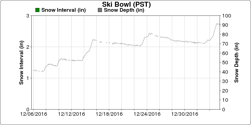
Storm update: As of Wednesday morning January 4, about 2 ft of new snow has already fallen on Mount Shasta at the Old Ski Bowl measurement site at 7600 ft, where snowdepth has increased from 70" to 91" (average January 1 snowdepth is about 76" at this site, increasing to 135" by April 15):
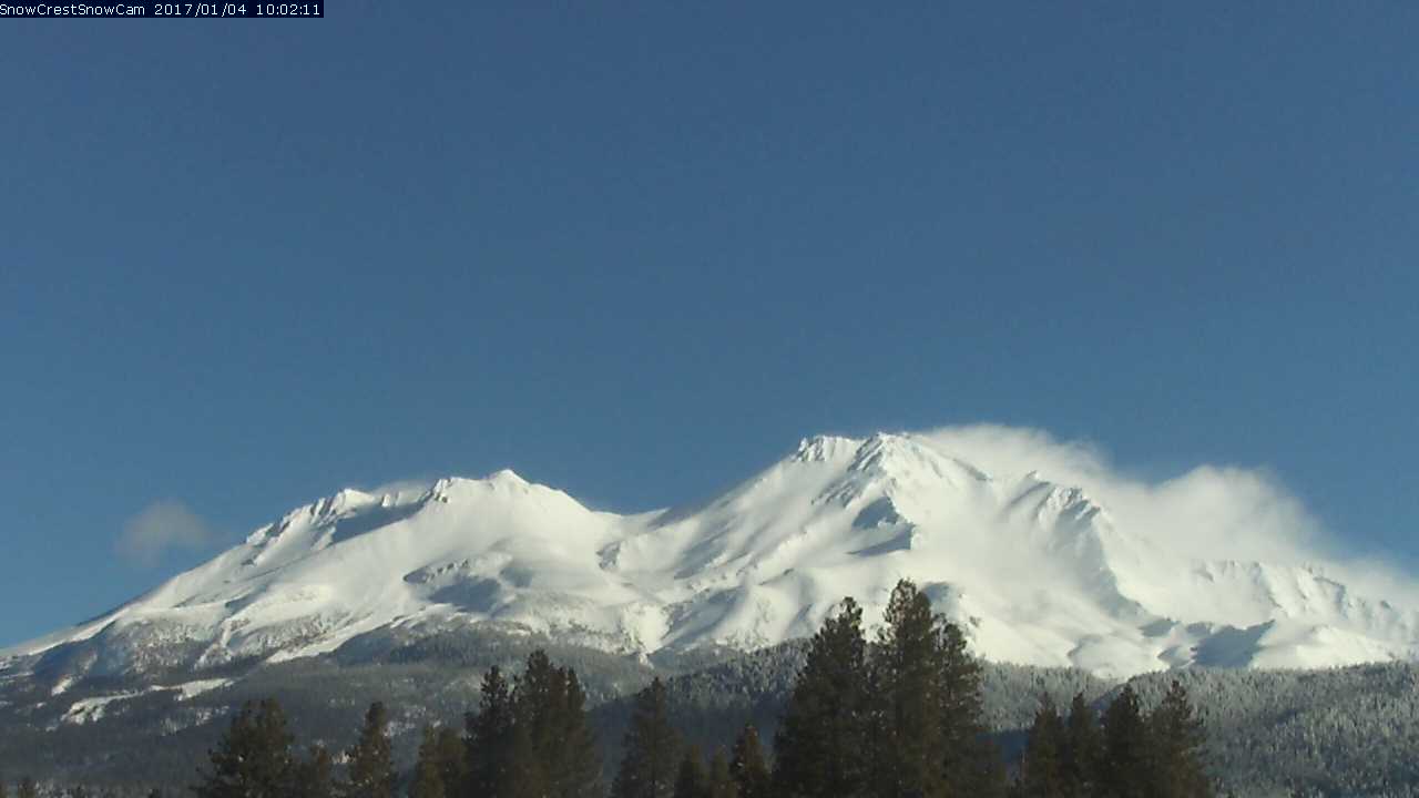
And after several days out of sight, Shasta reappeared once again from the clouds around 10am, in all her wintry glory:
Thanks for the kind words, I appreciate the support. It takes a substantial amount of time, effort, and research to write up these weather posts (and especially to try to make them as error-free as possible!), so I really have to be feeling motivated in order to write them. There also has to be some unusual or important weather event that intrigues me and actually feels worth writing about. I also need to have free time at the just the right time relative to the weather events, and not be off skiing a lot of days, nor on one of my frequent lengthy road trips to the southern end of the Cascade Range. So a lot of factors go into whether any weather posts get written or not.
Storm update: As of Wednesday morning January 4, about 2 ft of new snow has already fallen on Mount Shasta at the Old Ski Bowl measurement site at 7600 ft, where snowdepth has increased from 70" to 91" (average January 1 snowdepth is about 76" at this site, increasing to 135" by April 15):
And after several days out of sight, Shasta reappeared once again from the clouds around 10am, in all her wintry glory:
Stoked to see Amar's weather posts are back, I've missed them so!
Where ya been?!?
Thanks for bringing em back!
Thanks for the kind words, I appreciate the support. It takes a substantial amount of time, effort, and research to write up these weather posts (and especially to try to make them as error-free as possible!), so I really have to be feeling motivated in order to write them. There also has to be some unusual or important weather event that intrigues me and actually feels worth writing about. I also need to have free time at the just the right time relative to the weather events, and not be off skiing a lot of days, nor on one of my frequent lengthy road trips to the southern end of the Cascade Range. So a lot of factors go into whether any weather posts get written or not.
Please Log in or Create an account to join the conversation.
- alpentalcorey
- [alpentalcorey]
-
- Offline
- Junior Member
-
Less
More
- Posts: 180
- Thank you received: 0
05 Jan 2017 12:30 #228141
by alpentalcorey
Replied by alpentalcorey on topic Re: 10-20 ft Snowfall Predicted for CA, 02-13Jan2017!!
Just got off the phone a friend skiing at Kirkwood, he reports deep but ultra windblasted conditions so skiing more like a foot than the forehead-deep blower we could imagine. Hopefully helping a little with the drought.
Please Log in or Create an account to join the conversation.