- Posts: 635
- Thank you received: 0
Freak 2-3ft Snowfall at Mission & Hurricane Ridges
- Amar Andalkar
- [andalkar]
-
 Topic Author
- Offline
- Premium Member
-

Less
More
02 Jan 2017 16:39 - 07 Jan 2017 07:24 #228080
by Amar Andalkar
Freak 2-3ft Snowfall at Mission & Hurricane Ridges was created by Amar Andalkar
January 1-2, 2017: Freak Snowstorm Dumps over 2-3 ft of Snow at Hurricane Ridge and Mission Ridge!!!
but Near-ZERO Elsewhere in the Olympics and North/Central Cascades!?!?
One of the most bizarre snow events ever observed in the Northwest has just occurred on New Year's Day 2017, extending into January 2. Both Hurricane Ridge on the northern side of the Olympic Mountains and Mission Ridge at the easternmost end of the Central Cascades received over 2-3 ft of new snow in a 24 hour period, while many other normally high-snowfall sites in the North Cascades and Central Cascades got zero new snow over the same time period!

[size=small]Three images from the Hurricane Ridge webcam: before the storm on December 31, at the height of the storm on January 1, and after the storm on January 2.
The wind pit in the first image was over 8 ft deep, as some tourists stood inside it a couple hours later.[/size]
How's this for a truly absurd table of new 24-hour snowfall amounts as of January 2, 2017, at a few selected locations in roughly north-south order:
Mt Baker Ski Area 0" ??
Mazama 0" ??
Washington Pass 2" approx
Holden Village 0.5"
Hurricane Ridge 27" !!!
Lake Wenatchee 0" ??
Stevens Pass 0" ??
Snoqualmie Pass 0" ??
Blewett Pass 16"
Mission Ridge, Midway 27" !!!
Mission Ridge, Summit 39" !?!?!
Farther south in the South Washington Cascades and the Oregon Cascades, non-zero snowfall amounts occurred at most sites:
Crystal Mountain 4"
Mt Rainier, Sunrise 6" approx
Mt Rainier, Paradise 4" approx
White Pass 11"
Mt Hood, Timberline 12"
Mt Hood, Meadows 13"
Mt Bachelor Ski Area 10"
Crater Lake Park HQ 13"
Mt Ashland Ski Area 14"
It is almost certain that such an event (or anything even remotely similar) has never occurred before in the entire length of the historical weather records at these locations: combining extreme snowfall at those 2 totally-unrelated sites which are about 150 miles apart and located on opposite sides of the formidable weather barrier of the Cascade Crest (not to mention the waters of Puget Sound), along with near-zero snowfall at almost all other regional sites located between those 2 areas.
It boggles belief that this would even be possible at all. So where's the proof? Did it really happen at all?
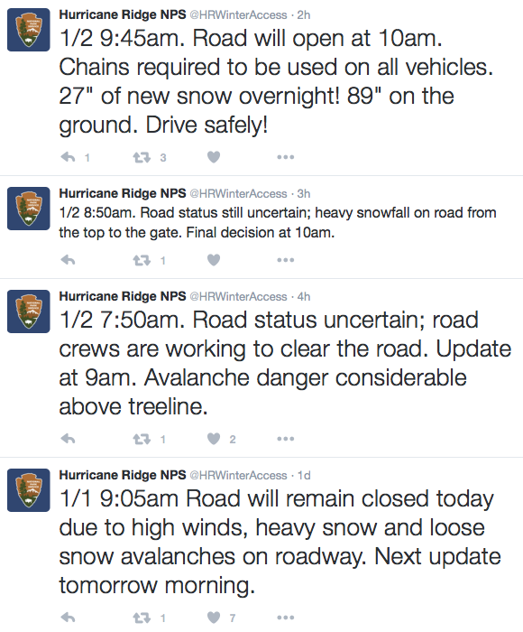
Here are the reports from Olympic NP and the ski areas in the North and Central Cascades. First the huge dumps of 2-3 ft:
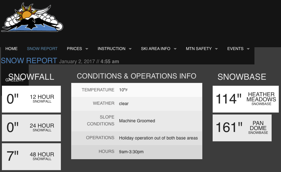
And over the same time period, ZERO at these ski areas which all have average annual snowfalls of 430-650":
And does NWAC telemetry support the manually reported snowfall amounts? It does so quite well as seen below. I first noticed the extreme snowfall at the Hurricane Ridge and Mission Ridge NWAC telemetry sites on the evening of January 1 (after returning from skiing 13" of blower powder in the backcountry near Stevens Pass), and was immediately shocked and intrigued by what was happening.
At Hurricane Ridge, there is no 24-hour snowdepth sensor, so the change in total snowdepth is the best info available. Starting from about 72" at midnight on the New Year, the depth rapidly increases to 89", implying well over 20" of new snow up to that point. The weight of the new snow makes the older snow compact and settle, so a 17" change in a large snowdepth is never only 17" of new snow, unless the older snowpack is either solidly rain-crusted on top, or else a very dense late-spring / summer snowpack. The 234" values are spurious, that's the height of the snow sensor above the ground, so if falling snow or windblown new snow blocks or obscures the ultrasonic distance sensor, it reads that full height until the sensor opening is cleared. It's too bad the sensor did not register any valid totals after 5pm, even as additional snowfall continued to fall. Also note that the total precip amounts are likely to be incorrect, as very light powdery snowfall with moderate to strong winds causes severe undercatch in the precip gauge, so it's very unlikely that the 27" new contained only 0.66" of precip as recorded from midnight onward (that would imply a density under 2.5%, which is not possible in this area). Total precip was likely at least 1.5" or more, with density of 5-6% or greater (still true blower powder if not wind-hammered).
For comparison at Baker Ski Area, 8" new snow fell by 4am on the New Year and almost no additional snowfall was received after that. Ski patrollers at the area obviously forgot to clear off the 24-hour snow board that morning, an omission which has unfortunately happened on a few other days recently at that site too.
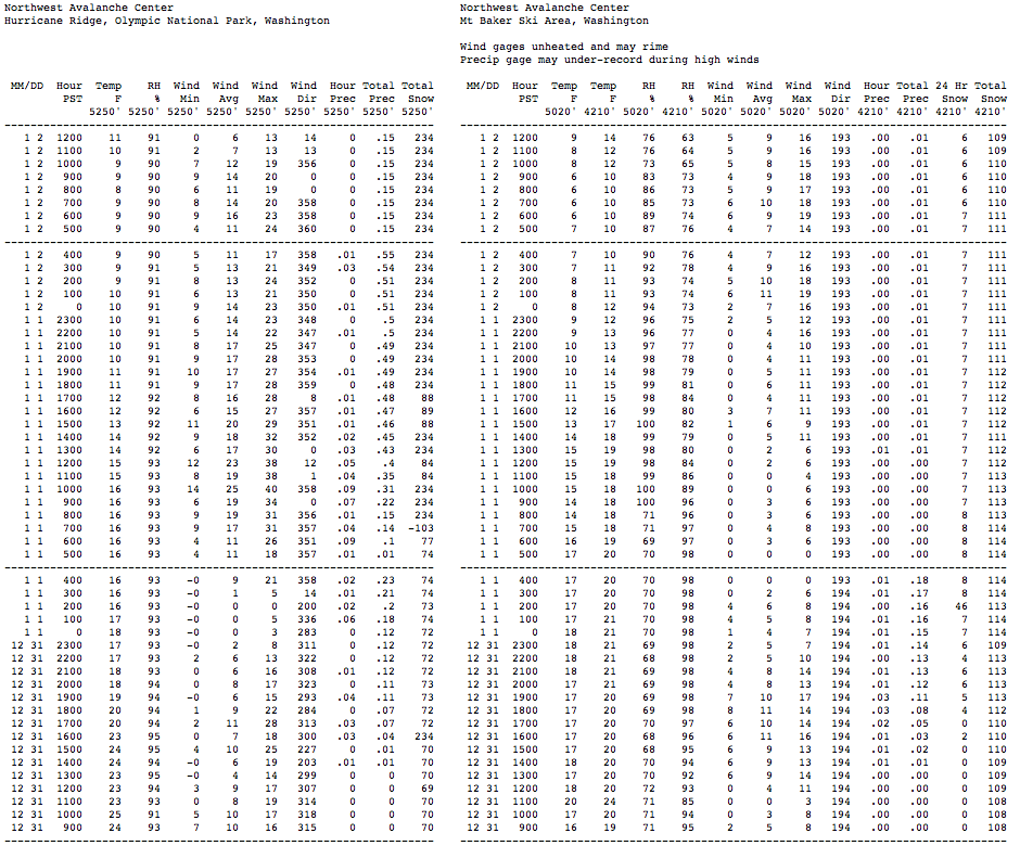
[size=small](These 2-column tables for nearby NWAC sites are generated by my NWAC script .)[/size]
We can also do a comparison with the Waterhole SNOTEL site, located 4 miles SE of Hurricane Ridge along Obstruction Point Road. Like all SNOTEL sites, which are mostly located in remote locations far from daily human activity, there is no 24-hour snow sensor and only total snowdepth. Once again, there is about an 18" increase in snowdepth, implying around 2 ft of new snow or more. The next closest SNOTEL site is the Dungeness SNOTEL, located on the west slope of Mount Townsend, about 21 miles ESE of Hurricane Ridge, and still on the northern slopes of the Olympics. This site shows about an 11" increase in snowdepth, implying perhaps 16" of new snow, so heavy snowfall apparently occurred along much of the northern Olympic slope. The precip amounts at both SNOTEL sites are also much more believable, with 1.8" at Waterhole and 1" at Dungeness, which imply a density of 6-7%, very realistic given the conditions and temperatures.
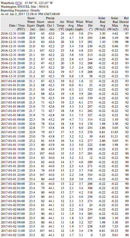

[size=small](Tables generated by my SNOTEL script .)[/size]
In sharp contrast to these sites in the northern Olympics, the 2 SNOTEL sites in other parts of the Olympic Mountains (Mount Crag and Buckinghorse SNOTEL, normally by far the snowiest site in the Olympics) showed very little snowfall during this event.
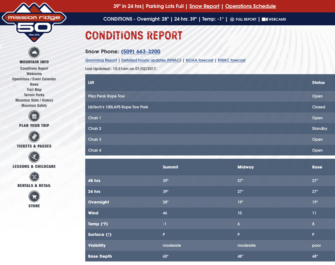
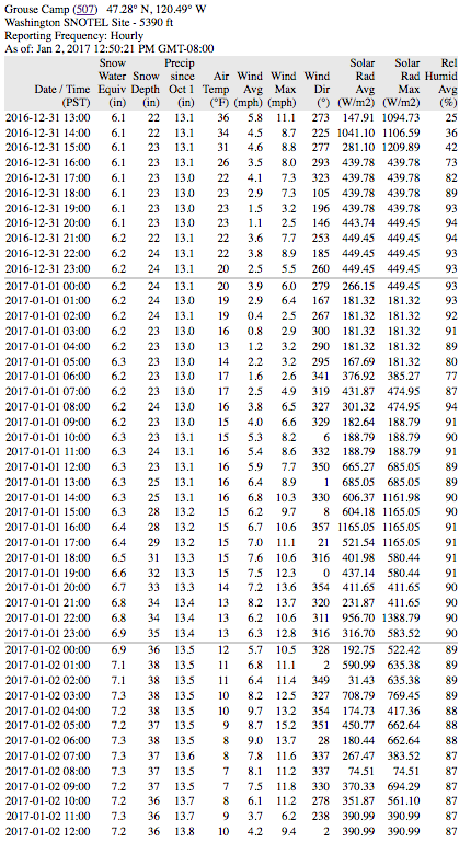
The Mission Ridge NWAC telemetry site is located at Midway, and it shows an increase in snowdepth of 23", from 20" up to 43". Even though there is a 24-hour sensor, the heavy snowfall obscured the sensor after 18" was recorded at midnight on January 2, and the 34" values after that are spurious, equal to the height of the sensor above the 24-hour snowfall board. Regardless, the 23" increase in depth is consistent with the reported 27" new snowfall amount. Once again as at Hurricane Ridge, the precip amount of 0.24" is far too low, and total precip was likely at least 1" or more, with density of 4% or greater. I'm not sure where the summit snowstake at Mission Ridge which showed 39" new is located, but perhaps someone who is very familiar with the area can post here and let me know (or even post a pic of the snowstake site). Note in particular the strong winds at the summit, which exceeded 100 mph during 2 hours at the peak of the storm, and gusted over 80 mph during 12 consecutive hours from 6pm January 1 to 5am January 2.
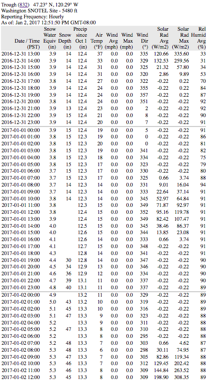
There are also 4 nearby SNOTEL sites which are well worth checking. The closest is the Upper Wheeler SNOTEL, located 1.5 miles east of the Mission Ridge Ski Area base and about 300 ft lower, which shows an increase from 15" up to 42", a 27" increase which given the shallow pre-existing snowpack, implies new snowfall of around 30" or more. The precip amount of 1.3" seems reasonable as it gives a 4% density.
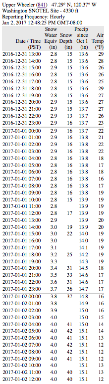
A bit farther eastward is the jackpot: the Trough SNOTEL near Naneum Ridge Rd, located 7 miles SE of the Mission Ridge Ski Area base, and only 9 miles west of the Columbia River, at roughly the same elevation as Midway on Mission. This site shows the largest new snowfall of any telemetry site, with an increase from 14" up to 48", an astonishing 34" increase which given the same shallow pre-existing snowpack, implies new snowfall of almost 40". So this completely matches the number reported from the Mission Ridge summit snowstake. The precip amount of 1" is at least closer to reality than the NWAC site, but is probably still well shy of the true value since it gives a density of only 2.5%, so it's probably over 1.5" which would give a 4% density.
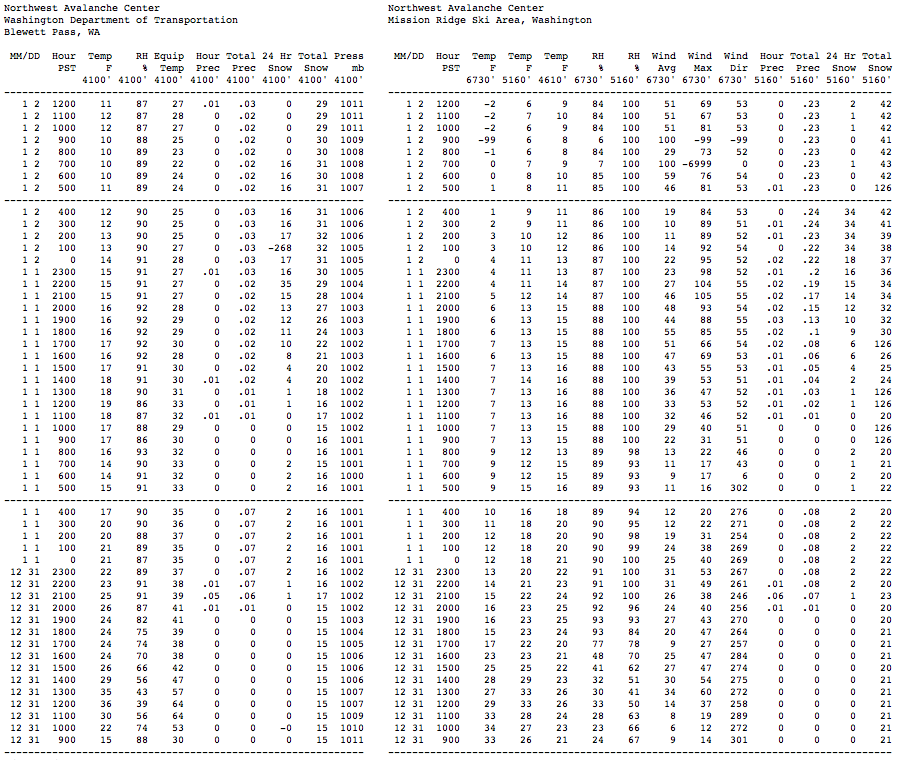
Heading westward, the Grouse Camp SNOTEL, located 3 miles west of the top of Mission Ridge Ski Area and 6 miles SE of Blewett Pass, shows an increase from 23" up to 38", a 15" increase which implies new snowfall near 18". Blewett Pass is only 9 miles WNW of Mission Ridge Ski Area, and the NWAC site there received 17" of snowfall during this event. The Blewett Pass SNOTEL site is actually located near old Blewett Pass, 5 miles WNW of Blewett Pass on US 97 and 14 miles WNW of Mission Ridge Ski Area, and it shows an increase from 22" to 30", implying new snowfall of nearly 1 ft. So there is clearly a gradient of decreasing snowfall heading westward along the Wenatchee Mountains, with maximum amounts near Mission Ridge and extending several miles east of it.
Meanwhile, other locations farther north and west such as the Sasse Ridge SNOTEL, located 1.5 miles east of the Salmon La Sac Road and 23 miles WNW of Blewett Pass, got very little new snowfall, perhaps 2-3" at most, while even farther north and west at Lake Wenatchee, Stevens Pass, and Snoqualmie Pass there was almost none.
So now that it's well verified that this bizzarre snowfall event combining both huge dumps and near-zero amounts actually did occur, the obvious question is what caused it?
The primary cause of both heavy snowfall events was a low-pressure system which moved onto the Pacific Coast and then tracked slowly eastward along roughly the WA-OR border (along the Columbia Gorge, but unrelated to any effects of the Gorge itself), almost stalling during the afternoon and evening hours of January 1. Watching this system on the radar, it was easy to see the obvious counterclockwise swirl of winds and precip around its center as it very slowly crept eastward over several hours. This particular storm track location causes southeasterly upslope winds along the Wenatchee Mountains (an ESE-trending branch of the Cascade Range) and also along the east slopes of the South Washington Cascades. It's the primary (perhaps only?) storm track which produces heavy snowfall in the usually snow-starved eastern end of the Wenatchee Mountains, in particular from around Mission Ridge towards the Columbia River. The non-zero snowfall amounts of a few inches to about 1 ft in the South Washington Cascades and the Oregon Cascades were just regular storm snowfall from this otherwise very typical wintertime low-pressure system.
Here's a plot from the UW WRF-GFS weather model showing the storm system at 4pm January 1, as the period of maximum snowfall intensity was underway at Mission Ridge and winding down at Hurricane Ridge. This graphic shows the initial pressure, temperature, and wind fields at the start of that model run on the 850 mb pressure surface, which is normally about 5000 ft elevation, but more like 4400 ft at this time due to low pressure (the central L of 1332 m = 4370 ft).
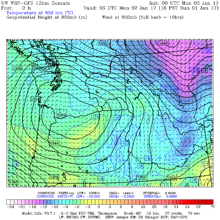
But how did a low-pressure system way down south along the Columbia Gorge cause the heavy snowfall on the northern slope of the Olympics? The very presence of low pressure in that region, combined with incoming extremely cold high pressure far to the northeast over the interior of BC, caused a strong pressure gradient and an increase in northeasterly outflow winds from the Frasier River canyon. This arctic outflow ends up aimed almost directly onto the northern slopes of the Olympic Mountains, and the cold dry air can entrain moisture as it crosses the relatively warm waters of the Salish Sea (Straits of Georgia and Juan de Fuca), resulting in heavy snowfall as the outflow is forced to rise up the northern slopes. Basically, it's ocean effect snowfall, very akin to lake effect snowfall such as on the Great Lakes, and similarly the snowfall rates can be very high at 2-4" per hour, easily producing 2 ft totals or more in favored locations such as Hurricane Ridge. In addition, the graphic shows that the wind field around the low-pressure system in this area is also aimed in the same northeasterly direction as the outflow, further enhancing the effect.
These are my own interpretations of the likely causes, and since I'm no meteorologist, they may have errors in some ways. Please post any corrections or other insights into the causes of this event. It's probably unusual enough to be worth someone writing it up as a published journal article.
Another question of great interest is whether any of this freakish snowfall was predicted at all by any weather forecast: the answer to that is pretty much a solid NO! No forecast was even hinting at these kind of snowfall amounts prior to the onset of the heavy snowfall, or even during the height of the heavy snowfall. As of the morning of January 1, the usually quite-reliable NWS zone forecast (www.wrh.noaa.gov/total_forecast/getprod....=sew&sid=sew&pil=zfp) for the Olympics said the following:
OLYMPICS-
400 AM PST SUN JAN 1 2017
TODAY...MOSTLY CLOUDY. A CHANCE OF SNOW SHOWERS IN THE MORNING... THEN A SLIGHT CHANCE OF SNOW SHOWERS IN THE AFTERNOON.
SNOW ACCUMULATION NEAR HURRICANE RIDGE AROUND 1 INCH.
Quite a difference between 1" predicted and 27" received!! Just before noon, after heavy snowfall had been occurring for hours, a Winter Weather Advisory was issued, and forecast snowfall amounts increased substantially:
OLYMPICS-
1148 AM PST SUN JAN 1 2017
...WINTER WEATHER ADVISORY IN EFFECT UNTIL 6 PM PST THIS EVENING...
REST OF TODAY...NUMEROUS SNOW SHOWERS. NEW SNOW ACCUMULATION NEAR HURRICANE RIDGE OF 4 TO 6 INCHES.
By that time, a foot of new had already fallen at Hurricane Ridge, and over another foot was on the way. Even the late afternoon update was still not really predicting that the heavy snowfall would continue as it did until well past midnight:
OLYMPICS-
343 PM PST SUN JAN 1 2017
...WINTER WEATHER ADVISORY IN EFFECT UNTIL 6 PM PST THIS EVENING...
TONIGHT...SNOW SHOWERS LIKELY. SNOW ACCUMULATION NEAR HURRICANE RIDGE OF 3 TO 5 INCHES.
So pretty much a solid miss on those forecasts for the Olympics.
What about near Mission Ridge? Unfortunately, the crest of the Wenatchee Mountains along the Chelan-Kittatas county line forms the border between the county forecast areas covered by the NWS Spokane and NWS Pendleton (OR) forecast offices, and neither office provides a zone forecast that really covers that area to even a minimal standard. They are on the border of the "East Slopes Northern Cascades" and "East Slopes of the Washington Cascades" zones from those 2 offices respectively, and the forecasts for each of those zones have little applicability to the type of highly-specific weather conditions in the Wenatchee Mountains which produce (the very rare) large snowfalls there. Didn't realize that until trying to look up the previous days zone forecasts now, that's a severe omission. So nothing to check there.
What about the UW WRF-GFS weather model , the fabled gold standard of Northwest weather prediction (especially mountain weather prediction) for the last decade or more. Did it see the heavy snowfall coming? Here's the final prediction for 24-hour snowfall through 4am January 2 over Washington, from the highest resolution 4/3-km run made on the morning of January 1:
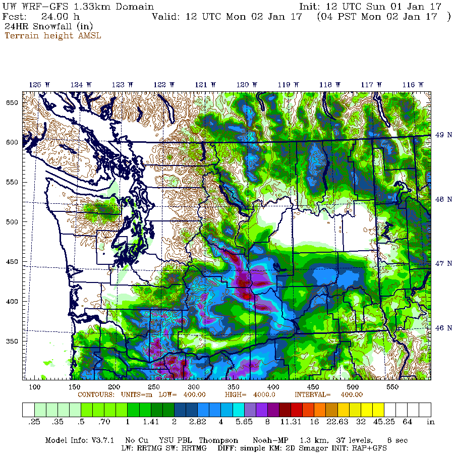
The same graphic, but showing the full 4/3-km domain which was recently expanded to include Oregon:

It certainly has the general idea correct, that there will be snowfall along the northern slopes of the Olympics and heavy snowfall along the crest of the Wenatchee Mountains, along with moderate snowfall throughout much of the South Washington Cascades and heavier snowfall up to 1 ft for the Oregon Cascades, and almost no snowfall for the North and Central Cascades, with amounts of 0-1" for most of that region. But the predicted snowfall amounts in what ended up as the heaviest snowfall areas are grossly incorrect, with only 2" predicted near Hurricane Ridge which turned into 27" and a maximum of 1 ft along the crest of the eastern Wenatchee Mountains near Mission Ridge which turned into over 3 ft.
As an interesting postscript, NWAC just posted their semimonthly snowdepth table for January 1, which showed snowdepths above normal at all sites listed except Mission Ridge, which was sadly well below normal. But only 1 day later, the snowdepth has doubled there, and the new depth of 42" is now about 135% of normal!
CLIMATOLOGICAL SNOWDEPTH INFORMATION
NORTHWEST AVALANCHE CENTER SEATTLE WASHINGTON
DAY 1 MONTH 1 YEAR 2017
DATA IN INCHES, -99 DENOTES MISSING DATA
CURRENT CLIMATE PER CENT LAST THRU 2016 THRU 2016
DEPTH AVERAGE OF NORMAL YEAR MAX/YEAR MIN/YEAR
HURRICANE 74 57 130 81 97/2013 11/1981
MT BAKER 114 88 130 105 190/1949 1/1928
STEVENS 76 61 125 56 117/1956 10/1981
SNOQUALMIE 63 53 119 77 136/1949 0/1981
STAMPEDE 61 57 107 68 132/1949 0/1981
MISSION22 42 31 71 135 37 56/1997 6/1976
CRYSTAL 47 42 112 51 72/2007 5/1981
PARADISE 111 91 122 116 163/1969 20/1977
WHITE PASS 49 36 136 59 84/1997 2/2014
TIMBERLINE 104 79 132 90 173/1985 8/1977
MEADOWS 79 71 111 79 145/1985 6/1981
but Near-ZERO Elsewhere in the Olympics and North/Central Cascades!?!?
One of the most bizarre snow events ever observed in the Northwest has just occurred on New Year's Day 2017, extending into January 2. Both Hurricane Ridge on the northern side of the Olympic Mountains and Mission Ridge at the easternmost end of the Central Cascades received over 2-3 ft of new snow in a 24 hour period, while many other normally high-snowfall sites in the North Cascades and Central Cascades got zero new snow over the same time period!
[size=small]Three images from the Hurricane Ridge webcam: before the storm on December 31, at the height of the storm on January 1, and after the storm on January 2.
The wind pit in the first image was over 8 ft deep, as some tourists stood inside it a couple hours later.[/size]
How's this for a truly absurd table of new 24-hour snowfall amounts as of January 2, 2017, at a few selected locations in roughly north-south order:
Mt Baker Ski Area 0" ??
Mazama 0" ??
Washington Pass 2" approx
Holden Village 0.5"
Hurricane Ridge 27" !!!
Lake Wenatchee 0" ??
Stevens Pass 0" ??
Snoqualmie Pass 0" ??
Blewett Pass 16"
Mission Ridge, Midway 27" !!!
Mission Ridge, Summit 39" !?!?!
Farther south in the South Washington Cascades and the Oregon Cascades, non-zero snowfall amounts occurred at most sites:
Crystal Mountain 4"
Mt Rainier, Sunrise 6" approx
Mt Rainier, Paradise 4" approx
White Pass 11"
Mt Hood, Timberline 12"
Mt Hood, Meadows 13"
Mt Bachelor Ski Area 10"
Crater Lake Park HQ 13"
Mt Ashland Ski Area 14"
It is almost certain that such an event (or anything even remotely similar) has never occurred before in the entire length of the historical weather records at these locations: combining extreme snowfall at those 2 totally-unrelated sites which are about 150 miles apart and located on opposite sides of the formidable weather barrier of the Cascade Crest (not to mention the waters of Puget Sound), along with near-zero snowfall at almost all other regional sites located between those 2 areas.
It boggles belief that this would even be possible at all. So where's the proof? Did it really happen at all?
Here are the reports from Olympic NP and the ski areas in the North and Central Cascades. First the huge dumps of 2-3 ft:
And over the same time period, ZERO at these ski areas which all have average annual snowfalls of 430-650":
And does NWAC telemetry support the manually reported snowfall amounts? It does so quite well as seen below. I first noticed the extreme snowfall at the Hurricane Ridge and Mission Ridge NWAC telemetry sites on the evening of January 1 (after returning from skiing 13" of blower powder in the backcountry near Stevens Pass), and was immediately shocked and intrigued by what was happening.
At Hurricane Ridge, there is no 24-hour snowdepth sensor, so the change in total snowdepth is the best info available. Starting from about 72" at midnight on the New Year, the depth rapidly increases to 89", implying well over 20" of new snow up to that point. The weight of the new snow makes the older snow compact and settle, so a 17" change in a large snowdepth is never only 17" of new snow, unless the older snowpack is either solidly rain-crusted on top, or else a very dense late-spring / summer snowpack. The 234" values are spurious, that's the height of the snow sensor above the ground, so if falling snow or windblown new snow blocks or obscures the ultrasonic distance sensor, it reads that full height until the sensor opening is cleared. It's too bad the sensor did not register any valid totals after 5pm, even as additional snowfall continued to fall. Also note that the total precip amounts are likely to be incorrect, as very light powdery snowfall with moderate to strong winds causes severe undercatch in the precip gauge, so it's very unlikely that the 27" new contained only 0.66" of precip as recorded from midnight onward (that would imply a density under 2.5%, which is not possible in this area). Total precip was likely at least 1.5" or more, with density of 5-6% or greater (still true blower powder if not wind-hammered).
For comparison at Baker Ski Area, 8" new snow fell by 4am on the New Year and almost no additional snowfall was received after that. Ski patrollers at the area obviously forgot to clear off the 24-hour snow board that morning, an omission which has unfortunately happened on a few other days recently at that site too.
[size=small](These 2-column tables for nearby NWAC sites are generated by my NWAC script .)[/size]
We can also do a comparison with the Waterhole SNOTEL site, located 4 miles SE of Hurricane Ridge along Obstruction Point Road. Like all SNOTEL sites, which are mostly located in remote locations far from daily human activity, there is no 24-hour snow sensor and only total snowdepth. Once again, there is about an 18" increase in snowdepth, implying around 2 ft of new snow or more. The next closest SNOTEL site is the Dungeness SNOTEL, located on the west slope of Mount Townsend, about 21 miles ESE of Hurricane Ridge, and still on the northern slopes of the Olympics. This site shows about an 11" increase in snowdepth, implying perhaps 16" of new snow, so heavy snowfall apparently occurred along much of the northern Olympic slope. The precip amounts at both SNOTEL sites are also much more believable, with 1.8" at Waterhole and 1" at Dungeness, which imply a density of 6-7%, very realistic given the conditions and temperatures.
[size=small](Tables generated by my SNOTEL script .)[/size]
In sharp contrast to these sites in the northern Olympics, the 2 SNOTEL sites in other parts of the Olympic Mountains (Mount Crag and Buckinghorse SNOTEL, normally by far the snowiest site in the Olympics) showed very little snowfall during this event.
The Mission Ridge NWAC telemetry site is located at Midway, and it shows an increase in snowdepth of 23", from 20" up to 43". Even though there is a 24-hour sensor, the heavy snowfall obscured the sensor after 18" was recorded at midnight on January 2, and the 34" values after that are spurious, equal to the height of the sensor above the 24-hour snowfall board. Regardless, the 23" increase in depth is consistent with the reported 27" new snowfall amount. Once again as at Hurricane Ridge, the precip amount of 0.24" is far too low, and total precip was likely at least 1" or more, with density of 4% or greater. I'm not sure where the summit snowstake at Mission Ridge which showed 39" new is located, but perhaps someone who is very familiar with the area can post here and let me know (or even post a pic of the snowstake site). Note in particular the strong winds at the summit, which exceeded 100 mph during 2 hours at the peak of the storm, and gusted over 80 mph during 12 consecutive hours from 6pm January 1 to 5am January 2.
There are also 4 nearby SNOTEL sites which are well worth checking. The closest is the Upper Wheeler SNOTEL, located 1.5 miles east of the Mission Ridge Ski Area base and about 300 ft lower, which shows an increase from 15" up to 42", a 27" increase which given the shallow pre-existing snowpack, implies new snowfall of around 30" or more. The precip amount of 1.3" seems reasonable as it gives a 4% density.
A bit farther eastward is the jackpot: the Trough SNOTEL near Naneum Ridge Rd, located 7 miles SE of the Mission Ridge Ski Area base, and only 9 miles west of the Columbia River, at roughly the same elevation as Midway on Mission. This site shows the largest new snowfall of any telemetry site, with an increase from 14" up to 48", an astonishing 34" increase which given the same shallow pre-existing snowpack, implies new snowfall of almost 40". So this completely matches the number reported from the Mission Ridge summit snowstake. The precip amount of 1" is at least closer to reality than the NWAC site, but is probably still well shy of the true value since it gives a density of only 2.5%, so it's probably over 1.5" which would give a 4% density.
Heading westward, the Grouse Camp SNOTEL, located 3 miles west of the top of Mission Ridge Ski Area and 6 miles SE of Blewett Pass, shows an increase from 23" up to 38", a 15" increase which implies new snowfall near 18". Blewett Pass is only 9 miles WNW of Mission Ridge Ski Area, and the NWAC site there received 17" of snowfall during this event. The Blewett Pass SNOTEL site is actually located near old Blewett Pass, 5 miles WNW of Blewett Pass on US 97 and 14 miles WNW of Mission Ridge Ski Area, and it shows an increase from 22" to 30", implying new snowfall of nearly 1 ft. So there is clearly a gradient of decreasing snowfall heading westward along the Wenatchee Mountains, with maximum amounts near Mission Ridge and extending several miles east of it.
Meanwhile, other locations farther north and west such as the Sasse Ridge SNOTEL, located 1.5 miles east of the Salmon La Sac Road and 23 miles WNW of Blewett Pass, got very little new snowfall, perhaps 2-3" at most, while even farther north and west at Lake Wenatchee, Stevens Pass, and Snoqualmie Pass there was almost none.
So now that it's well verified that this bizzarre snowfall event combining both huge dumps and near-zero amounts actually did occur, the obvious question is what caused it?
The primary cause of both heavy snowfall events was a low-pressure system which moved onto the Pacific Coast and then tracked slowly eastward along roughly the WA-OR border (along the Columbia Gorge, but unrelated to any effects of the Gorge itself), almost stalling during the afternoon and evening hours of January 1. Watching this system on the radar, it was easy to see the obvious counterclockwise swirl of winds and precip around its center as it very slowly crept eastward over several hours. This particular storm track location causes southeasterly upslope winds along the Wenatchee Mountains (an ESE-trending branch of the Cascade Range) and also along the east slopes of the South Washington Cascades. It's the primary (perhaps only?) storm track which produces heavy snowfall in the usually snow-starved eastern end of the Wenatchee Mountains, in particular from around Mission Ridge towards the Columbia River. The non-zero snowfall amounts of a few inches to about 1 ft in the South Washington Cascades and the Oregon Cascades were just regular storm snowfall from this otherwise very typical wintertime low-pressure system.
Here's a plot from the UW WRF-GFS weather model showing the storm system at 4pm January 1, as the period of maximum snowfall intensity was underway at Mission Ridge and winding down at Hurricane Ridge. This graphic shows the initial pressure, temperature, and wind fields at the start of that model run on the 850 mb pressure surface, which is normally about 5000 ft elevation, but more like 4400 ft at this time due to low pressure (the central L of 1332 m = 4370 ft).
But how did a low-pressure system way down south along the Columbia Gorge cause the heavy snowfall on the northern slope of the Olympics? The very presence of low pressure in that region, combined with incoming extremely cold high pressure far to the northeast over the interior of BC, caused a strong pressure gradient and an increase in northeasterly outflow winds from the Frasier River canyon. This arctic outflow ends up aimed almost directly onto the northern slopes of the Olympic Mountains, and the cold dry air can entrain moisture as it crosses the relatively warm waters of the Salish Sea (Straits of Georgia and Juan de Fuca), resulting in heavy snowfall as the outflow is forced to rise up the northern slopes. Basically, it's ocean effect snowfall, very akin to lake effect snowfall such as on the Great Lakes, and similarly the snowfall rates can be very high at 2-4" per hour, easily producing 2 ft totals or more in favored locations such as Hurricane Ridge. In addition, the graphic shows that the wind field around the low-pressure system in this area is also aimed in the same northeasterly direction as the outflow, further enhancing the effect.
These are my own interpretations of the likely causes, and since I'm no meteorologist, they may have errors in some ways. Please post any corrections or other insights into the causes of this event. It's probably unusual enough to be worth someone writing it up as a published journal article.
Another question of great interest is whether any of this freakish snowfall was predicted at all by any weather forecast: the answer to that is pretty much a solid NO! No forecast was even hinting at these kind of snowfall amounts prior to the onset of the heavy snowfall, or even during the height of the heavy snowfall. As of the morning of January 1, the usually quite-reliable NWS zone forecast (www.wrh.noaa.gov/total_forecast/getprod....=sew&sid=sew&pil=zfp) for the Olympics said the following:
OLYMPICS-
400 AM PST SUN JAN 1 2017
TODAY...MOSTLY CLOUDY. A CHANCE OF SNOW SHOWERS IN THE MORNING... THEN A SLIGHT CHANCE OF SNOW SHOWERS IN THE AFTERNOON.
SNOW ACCUMULATION NEAR HURRICANE RIDGE AROUND 1 INCH.
Quite a difference between 1" predicted and 27" received!! Just before noon, after heavy snowfall had been occurring for hours, a Winter Weather Advisory was issued, and forecast snowfall amounts increased substantially:
OLYMPICS-
1148 AM PST SUN JAN 1 2017
...WINTER WEATHER ADVISORY IN EFFECT UNTIL 6 PM PST THIS EVENING...
REST OF TODAY...NUMEROUS SNOW SHOWERS. NEW SNOW ACCUMULATION NEAR HURRICANE RIDGE OF 4 TO 6 INCHES.
By that time, a foot of new had already fallen at Hurricane Ridge, and over another foot was on the way. Even the late afternoon update was still not really predicting that the heavy snowfall would continue as it did until well past midnight:
OLYMPICS-
343 PM PST SUN JAN 1 2017
...WINTER WEATHER ADVISORY IN EFFECT UNTIL 6 PM PST THIS EVENING...
TONIGHT...SNOW SHOWERS LIKELY. SNOW ACCUMULATION NEAR HURRICANE RIDGE OF 3 TO 5 INCHES.
So pretty much a solid miss on those forecasts for the Olympics.
What about near Mission Ridge? Unfortunately, the crest of the Wenatchee Mountains along the Chelan-Kittatas county line forms the border between the county forecast areas covered by the NWS Spokane and NWS Pendleton (OR) forecast offices, and neither office provides a zone forecast that really covers that area to even a minimal standard. They are on the border of the "East Slopes Northern Cascades" and "East Slopes of the Washington Cascades" zones from those 2 offices respectively, and the forecasts for each of those zones have little applicability to the type of highly-specific weather conditions in the Wenatchee Mountains which produce (the very rare) large snowfalls there. Didn't realize that until trying to look up the previous days zone forecasts now, that's a severe omission. So nothing to check there.
What about the UW WRF-GFS weather model , the fabled gold standard of Northwest weather prediction (especially mountain weather prediction) for the last decade or more. Did it see the heavy snowfall coming? Here's the final prediction for 24-hour snowfall through 4am January 2 over Washington, from the highest resolution 4/3-km run made on the morning of January 1:
The same graphic, but showing the full 4/3-km domain which was recently expanded to include Oregon:
It certainly has the general idea correct, that there will be snowfall along the northern slopes of the Olympics and heavy snowfall along the crest of the Wenatchee Mountains, along with moderate snowfall throughout much of the South Washington Cascades and heavier snowfall up to 1 ft for the Oregon Cascades, and almost no snowfall for the North and Central Cascades, with amounts of 0-1" for most of that region. But the predicted snowfall amounts in what ended up as the heaviest snowfall areas are grossly incorrect, with only 2" predicted near Hurricane Ridge which turned into 27" and a maximum of 1 ft along the crest of the eastern Wenatchee Mountains near Mission Ridge which turned into over 3 ft.
As an interesting postscript, NWAC just posted their semimonthly snowdepth table for January 1, which showed snowdepths above normal at all sites listed except Mission Ridge, which was sadly well below normal. But only 1 day later, the snowdepth has doubled there, and the new depth of 42" is now about 135% of normal!
CLIMATOLOGICAL SNOWDEPTH INFORMATION
NORTHWEST AVALANCHE CENTER SEATTLE WASHINGTON
DAY 1 MONTH 1 YEAR 2017
DATA IN INCHES, -99 DENOTES MISSING DATA
CURRENT CLIMATE PER CENT LAST THRU 2016 THRU 2016
DEPTH AVERAGE OF NORMAL YEAR MAX/YEAR MIN/YEAR
HURRICANE 74 57 130 81 97/2013 11/1981
MT BAKER 114 88 130 105 190/1949 1/1928
STEVENS 76 61 125 56 117/1956 10/1981
SNOQUALMIE 63 53 119 77 136/1949 0/1981
STAMPEDE 61 57 107 68 132/1949 0/1981
MISSION
CRYSTAL 47 42 112 51 72/2007 5/1981
PARADISE 111 91 122 116 163/1969 20/1977
WHITE PASS 49 36 136 59 84/1997 2/2014
TIMBERLINE 104 79 132 90 173/1985 8/1977
MEADOWS 79 71 111 79 145/1985 6/1981
Please Log in or Create an account to join the conversation.
- flowing alpy
- [flowing alpy]
-
- Offline
- Platinum Member
-

Less
More
- Posts: 1272
- Thank you received: 0
02 Jan 2017 16:54 #228081
by flowing alpy
Replied by flowing alpy on topic Re: Freak 2-3ft Snowfall at Mission & Hurricane Ridges
Thanks Amar! totally makes sense when you explain it like that.
Please Log in or Create an account to join the conversation.
- aaron_wright
- [aaron_wright]
-
- Offline
- Senior Member
-

Less
More
- Posts: 429
- Thank you received: 0
02 Jan 2017 18:14 #228082
by aaron_wright
Replied by aaron_wright on topic Re: Freak 2-3ft Snowfall at Mission & Hurricane Ridges
This happens infrequently here at Mission Amar but the cyclonic low pressure systems that track through the Columbia Gorge are well know snow makers here. If they spin up into the basin and get sandwiched between an advancing arctic front and warm front to the south we get these "freak" snowfalls. Last one I remember was 1/10-11/07.
When I drove up yesterday around noon, there were patches of blue sky to the north in town and as I drove further up the canyon the snow steadily increase to near blizzard conditions by the time I got to the lot. I had 8"+ on my car from noon to 4:45 when I left.
When I drove up yesterday around noon, there were patches of blue sky to the north in town and as I drove further up the canyon the snow steadily increase to near blizzard conditions by the time I got to the lot. I had 8"+ on my car from noon to 4:45 when I left.
Please Log in or Create an account to join the conversation.
- Amar Andalkar
- [andalkar]
-
Topic Author
- Offline
- Premium Member
-
Less
More
- Posts: 635
- Thank you received: 0
02 Jan 2017 19:45 - 03 Jan 2017 22:55 #228086
by Amar Andalkar
Replied by Amar Andalkar on topic Re: Freak 2-3ft Snowfall at Mission & Hurricane Ridges
Edited the original post to add an analysis of the forecast predictions, which obviously did not see this heavy snowfall coming very well at all . . .
And also added the three-image animation from the Hurricane Ridge webcam.
Later added the 850 mb graphic, the 2nd model snowfall graphic covering both OR and WA, and made several other tweaks.
Note that there was some kind of major data outage around midnight on January 2 which affected all of the over 1100 SNOTEL and SCAN telemetry sites run by NRCS nationwide, so all those sites were missing 6-7 hours of data at the time the original post was written. On January 3, the missing data reappeared, and so the 5 SNOTEL data tables in the original post were updated to include that missing data.
Please Log in or Create an account to join the conversation.
- jtack
- [jtack]
-
- Offline
- Junior Member
-

Less
More
- Posts: 126
- Thank you received: 1
03 Jan 2017 07:46 - 03 Jan 2017 08:02 #228092
by jtack
Replied by jtack on topic Re: Freak 2-3ft Snowfall at Mission & Hurricane Ridges
Amar, while it is unprecedented to get the amount of snow we had yesterday, events like this, all be it much shorter in length happen almost every year. (a non scientific observation of similar conditions)
Jan 1, at the top of the lift, you could see the sun shining through the obscuration formed by the weather piling in from the east. In Wenatchee ten air miles east, we had two inches accumulation from Jan 1 and 2.
The skiing was deep.
Jan 1, at the top of the lift, you could see the sun shining through the obscuration formed by the weather piling in from the east. In Wenatchee ten air miles east, we had two inches accumulation from Jan 1 and 2.
The skiing was deep.
Please Log in or Create an account to join the conversation.
- Stormking
- [Stormking]
-
- Offline
- Junior Member
-
Less
More
- Posts: 83
- Thank you received: 0
03 Jan 2017 11:05 - 03 Jan 2017 12:50 #228095
by Stormking
Replied by Stormking on topic Re: Freak 2-3ft Snowfall at Mission & Hurricane Ridges
Nice write up. I did a paper about the northern Olympic Peninsula strait effect snow phenomena while at UW in the early '90s. I was inspired after a similar storm that happened then which dumped 30" of snow at the 500+ foot level in the PA area, while the rest of the PNW was clear and cold. At that time, I did not think to see if there was a connection to Mission Ridge snowfall.
I've noticed that the NWS has mentioned strait effect snow as a possibility a few times in recent years with Fraser Outflow events. Enough that I didn't expect it to happen this time because it wasn't mentioned and figured they had a handle on why it wouldn't.
Also of note was that on the 30th, when the outflow was first beginning, the band of moisture was more at the 4,000' level. Above that elevation was clear, but a fairly heavy snowfall in the band of clouds that changed to rain just at sea level, and then clear again out over the Strait. I have some pictures of that if I can figure out to get them from my phone to this site. Made for a beautiful alpenglow sunset. Also, the snow continued to fall all day on the 2nd at the Ridge, while it was pretty much clear in town.
BTW the skiing was fantastic. (And very unfortunate that the road is now closed at the gate with all that blower pow up there).
Please Log in or Create an account to join the conversation.
- ski_photomatt
- [ski_photomatt]
-
- Offline
- Junior Member
-
Less
More
- Posts: 141
- Thank you received: 0
03 Jan 2017 11:38 #228096
by ski_photomatt
Replied by ski_photomatt on topic Re: Freak 2-3ft Snowfall at Mission & Hurricane Ridges
Super interesting, thanks for the write up Amar and additional context everyone. Stormking do you have a link to the paper, I'd like to see it.
Does anyone (Amar?) have access to the historical telemetry data in an easy to analyze form? I think it would be interesting to quantify how frequently this occurs. It should be easy to write a few simple rules to find events like this in the historical data once it is in an easy to analyze form.
Does anyone (Amar?) have access to the historical telemetry data in an easy to analyze form? I think it would be interesting to quantify how frequently this occurs. It should be easy to write a few simple rules to find events like this in the historical data once it is in an easy to analyze form.
Please Log in or Create an account to join the conversation.
- RonL
- [RonL]
-
- Offline
- Senior Member
-
Less
More
- Posts: 259
- Thank you received: 0
03 Jan 2017 12:50 #228099
by RonL
Replied by RonL on topic Re: Freak 2-3ft Snowfall at Mission & Hurricane Ridges
Cool stuff. The cliff mass blog has a bit about the mission ridge part, I think he mentioned the Pendleton site showed an update that hinted toward it but was still not expecting quite that much.
Please Log in or Create an account to join the conversation.
- Stormking
- [Stormking]
-
- Offline
- Junior Member
-
Less
More
- Posts: 83
- Thank you received: 0
03 Jan 2017 12:53 - 03 Jan 2017 12:59 #228100
by Stormking
Replied by Stormking on topic Re: Freak 2-3ft Snowfall at Mission & Hurricane Ridges
Haha. No link for sure. I'm old and this was before the age of computers. My recollection is that I hand wrote it, for sure hand typed. I might still have it laying around somewhere. Not sure I'm brave enough to post a sample of my freshman year writing though, even if I did get an A+ as I recall.
Please Log in or Create an account to join the conversation.
- Amar Andalkar
- [andalkar]
-
Topic Author
- Offline
- Premium Member
-
Less
More
- Posts: 635
- Thank you received: 0
03 Jan 2017 19:31 - 04 Jan 2017 11:47 #228114
by Amar Andalkar
Jtack, maybe you're looking at this in a way that's too Mission-Ridge-specific. And maybe I wasn't clear enough in the original post, so I'll try to clarify in case others are also thinking that this event is only slightly unusual, and I'm making a big deal over nothing.
The unprecedented thing about this event is not the 3+ ft of snow at Mission, even though that may be a record 24-hour snowfall at that site (does anyone know what their record is?). It's the combination of 3+ ft at Mission, 2+ ft at Hurricane, and ZERO at almost all sites along the line connecting those 2 regions and also north of that line, over a vast mountainous region that typically gets heavy snowfalls throughout whenever it snows at both Hurricane and Mission. That is the total "event" that I'm writing about, and such an event basically never occurs, I wouldn't be surprised if its statistical period-of-return (if that could even be estimated in the most approximate way) were far beyond a 1-in-100 year event, perhaps even 1-in-1000 years or more. It's the zero snowfall between the 2 huge snowfalls that makes it so bizarre, improbable, and unprecedented. Certainly I can't recall seeing anything remotely like this 2ft-ZERO-3ft combination over the 23 winters since I moved to Seattle.
A very specific set of circumstances was required to allow this event to happen: in addition to needing (1) a strong-enough, wet-enough low-pressure system tracking eastward on a specific path along the Columbia Gorge which is conducive to heavy upslope snowfall near Mission Ridge and (2) then slowing/stalling in just the right place along that path to dump heavy snowfall for many hours at Mission, there needs to be (3) a large mass of cold Arctic air already in place over the interior of BC to allow the very strong Fraser outflow to develop, and (4) that outflow needs to continue for roughly the same period of many hours on the same day in order to simultaneously dump heavy snowfall at Hurricane Ridge. But in order to get zero snowfall over the North and Central Cascades during the same day, (5) the cold Arctic air must also have leaked south on both sides of the Cascades by the time that low comes ashore, at least down past the latitude of Snoqualmie Pass and not just be sitting up in BC, and then (6) that cold Arctic air needs to have arrived in large enough quantity to completely shut off and prevent snowfall over that entire North-Central Cascades region as the storm system slowly tracks eastward just to the south.
The hard part about figuring out how unlikely this event is, is that (as you say) there may be some degree of correlation between some of these 6 circumstances which are required. But it may not be much correlation, as the low-pressure systems that do follow that specific track and do give heavy snowfall to Mission every few years can readily occur irrespective of any Arctic air mass in place over the Northwest or BC. The eastern Cascades are easily cold enough throughout winter to have snowfall at the 4600-6800 ft elevations of Mission Ridge even during normal seasonable temperatures.
My gut feeling (and it's only a guess as of now, since I haven't had time to even try to look through older data) is that any previous time in the historical record that both Mission Ridge and Hurricane Ridge have gotten heavy snowfall on the same day (let's say both got at least a foot in 24 hours), that large areas of the North and Central Cascades would have gotten at least a few inches of snowfall during the same day too. Certainly the same SE upslope winds which dump snow at Mission can easily reach the Snoqualmie Pass region up the Kittitas Valley and simultaneously produce snowfall there, unless enough cold Arctic air is already in place there to prevent that like this time.
Cliff mentions the Pendleton radar data in his blog, but not the NWS Pendleton forecast office, which was probably just as completely blindsided by the extreme snowfall totals at Mission Ridge as the NWS Seattle office was by the extreme snowfall at Hurricane Ridge.
I do have the complete archive of NWAC telemetry data extending back to the 1980s, which Garth was kind enough to send to me on CD-ROM way back in 2005 (what's a CD-ROM? the kids will soon say). However, it's not exactly in an easy to use format, it's just raw CSV files for each site and year, and looks nothing like the current 10 days of telemetry data posted on the NWAC website. But it wouldn't be hard to write a script to analyze it for the simple purposes of looking at snowfall at Mission and Hurricane. Since my version is 12 years old, it would be best to get the full data set from Garth or other forecasters at NWAC.
The real issue (as always with snow sensor data) is getting rid of the data spikes which go up to the maximum snowdepth or some other high value, which are always going to occur with an ultrasonic distance sensor in a snow-stormy environment, and especially tend to occur most often during heavy snowfall accompanied by high winds. There is no way other than manually going through and looking at the data to mask those out, or at least I can't think of a 100% robust way to program such spike removal without some chance of accidentally excluding valid high-snowfall data.
Since October 2004, I have manually saved the current 10 days of NWAC telemetry data (data.nwac.us/ files ALL.x) at least once every 10 days. This was eventually supplemented by a script which saves the NWAC data.nwac.us/ALL data file every hour, which helps me to manually fill in missing hours of data from the daily ALL.x files caused by the all-too-frequent NWAC data computer crashes. In 2011, I wrote a script which concatenates the data for any single NWAC site for an entire snow year (Oct-Sept), and extracts hours with maximum winds above a chosen value, for use in various TAY threads about high winds at Mission and Camp Muir. Although not intended for public use, my script does provide an easy way to get the data for a full year for any site in a very easy to use format, same as the daily NWAC data, but only back to the 2004-5 season:
www.skimountaineer.com/NWAC/NWAC-SeasonData.php
I've been planning to add several other capabilities to this script at some point (precip totals and max, snowfall totals and max), but haven't gotten around to that yet. Happy to hear any suggestions for improvements to my various telemetry scripts such as this one, or my NWAC 10-day script , or my SNOTEL script .
For the SNOTEL sites near Hurricane and Mission, my SNOTEL script can spit out up to 3 years of hourly data at a time, which was a limitation in the NRCS Report Generator which provides the actual data. Daily snowfall would have to be calculated/estimated from the change in snowdepth.
The Dungeness SNOTEL site was installed in 1998, and Waterhole SNOTEL in 1999, and both included a snowdepth sensor from the start, quite unusually for SNOTEL sites of that era. Most SNOTEL sites did not get snowdepth sensors until the mid-2000s, prior to that there was only a SWE (snow water equivalent) pillow sensor at most sites, which is totally useless for figuring out snowfall. The Trough SNOTEL site was installed way back in 1978, but the snowdepth sensor was not installed until 2001. Similarly the Upper Wheeler SNOTEL and Grouse Camp SNOTEL were both installed in 1980, and got snowdepth sensors in 2002 and 2003. So snowfall data and any information about large snowfall events extends back only 15-20 years for the SNOTEL sites in the northern Olympics and eastern Wenatchee Mountains.
Replied by Amar Andalkar on topic Re: Freak 2-3ft Snowfall at Mission & Hurricane Ridges
Amar, while it is unprecedented to get the amount of snow we had yesterday, events like this, all be it much shorter in length happen almost every year. (a non scientific observation of similar conditions)
Jtack, maybe you're looking at this in a way that's too Mission-Ridge-specific. And maybe I wasn't clear enough in the original post, so I'll try to clarify in case others are also thinking that this event is only slightly unusual, and I'm making a big deal over nothing.
The unprecedented thing about this event is not the 3+ ft of snow at Mission, even though that may be a record 24-hour snowfall at that site (does anyone know what their record is?). It's the combination of 3+ ft at Mission, 2+ ft at Hurricane, and ZERO at almost all sites along the line connecting those 2 regions and also north of that line, over a vast mountainous region that typically gets heavy snowfalls throughout whenever it snows at both Hurricane and Mission. That is the total "event" that I'm writing about, and such an event basically never occurs, I wouldn't be surprised if its statistical period-of-return (if that could even be estimated in the most approximate way) were far beyond a 1-in-100 year event, perhaps even 1-in-1000 years or more. It's the zero snowfall between the 2 huge snowfalls that makes it so bizarre, improbable, and unprecedented. Certainly I can't recall seeing anything remotely like this 2ft-ZERO-3ft combination over the 23 winters since I moved to Seattle.
Amar, it seems to be that the only way this (lots of snow at Hurricane and Mission and none elsewhere)happens is with a specific set of weather circumstances, i.e. Fraser outflow events. I don't think it is that uncommon for those to be associated with a low down in Oregon somewhere- that is what sucks the cold air out of Canada. The wrap around moisture falling on the east slopes of the Cascades (Mission)may often be a part of the whole set up.
A very specific set of circumstances was required to allow this event to happen: in addition to needing (1) a strong-enough, wet-enough low-pressure system tracking eastward on a specific path along the Columbia Gorge which is conducive to heavy upslope snowfall near Mission Ridge and (2) then slowing/stalling in just the right place along that path to dump heavy snowfall for many hours at Mission, there needs to be (3) a large mass of cold Arctic air already in place over the interior of BC to allow the very strong Fraser outflow to develop, and (4) that outflow needs to continue for roughly the same period of many hours on the same day in order to simultaneously dump heavy snowfall at Hurricane Ridge. But in order to get zero snowfall over the North and Central Cascades during the same day, (5) the cold Arctic air must also have leaked south on both sides of the Cascades by the time that low comes ashore, at least down past the latitude of Snoqualmie Pass and not just be sitting up in BC, and then (6) that cold Arctic air needs to have arrived in large enough quantity to completely shut off and prevent snowfall over that entire North-Central Cascades region as the storm system slowly tracks eastward just to the south.
The hard part about figuring out how unlikely this event is, is that (as you say) there may be some degree of correlation between some of these 6 circumstances which are required. But it may not be much correlation, as the low-pressure systems that do follow that specific track and do give heavy snowfall to Mission every few years can readily occur irrespective of any Arctic air mass in place over the Northwest or BC. The eastern Cascades are easily cold enough throughout winter to have snowfall at the 4600-6800 ft elevations of Mission Ridge even during normal seasonable temperatures.
My gut feeling (and it's only a guess as of now, since I haven't had time to even try to look through older data) is that any previous time in the historical record that both Mission Ridge and Hurricane Ridge have gotten heavy snowfall on the same day (let's say both got at least a foot in 24 hours), that large areas of the North and Central Cascades would have gotten at least a few inches of snowfall during the same day too. Certainly the same SE upslope winds which dump snow at Mission can easily reach the Snoqualmie Pass region up the Kittitas Valley and simultaneously produce snowfall there, unless enough cold Arctic air is already in place there to prevent that like this time.
Cool stuff. The cliff mass blog has a bit about the mission ridge part, I think he mentioned the Pendleton site showed an update that hinted toward it but was still not expecting quite that much.
Cliff mentions the Pendleton radar data in his blog, but not the NWS Pendleton forecast office, which was probably just as completely blindsided by the extreme snowfall totals at Mission Ridge as the NWS Seattle office was by the extreme snowfall at Hurricane Ridge.
Does anyone (Amar?) have access to the historical telemetry data in an easy to analyze form? I think it would be interesting to quantify how frequently this occurs. It should be easy to write a few simple rules to find events like this in the historical data once it is in an easy to analyze form.
I do have the complete archive of NWAC telemetry data extending back to the 1980s, which Garth was kind enough to send to me on CD-ROM way back in 2005 (what's a CD-ROM? the kids will soon say). However, it's not exactly in an easy to use format, it's just raw CSV files for each site and year, and looks nothing like the current 10 days of telemetry data posted on the NWAC website. But it wouldn't be hard to write a script to analyze it for the simple purposes of looking at snowfall at Mission and Hurricane. Since my version is 12 years old, it would be best to get the full data set from Garth or other forecasters at NWAC.
The real issue (as always with snow sensor data) is getting rid of the data spikes which go up to the maximum snowdepth or some other high value, which are always going to occur with an ultrasonic distance sensor in a snow-stormy environment, and especially tend to occur most often during heavy snowfall accompanied by high winds. There is no way other than manually going through and looking at the data to mask those out, or at least I can't think of a 100% robust way to program such spike removal without some chance of accidentally excluding valid high-snowfall data.
Since October 2004, I have manually saved the current 10 days of NWAC telemetry data (data.nwac.us/ files ALL.x) at least once every 10 days. This was eventually supplemented by a script which saves the NWAC data.nwac.us/ALL data file every hour, which helps me to manually fill in missing hours of data from the daily ALL.x files caused by the all-too-frequent NWAC data computer crashes. In 2011, I wrote a script which concatenates the data for any single NWAC site for an entire snow year (Oct-Sept), and extracts hours with maximum winds above a chosen value, for use in various TAY threads about high winds at Mission and Camp Muir. Although not intended for public use, my script does provide an easy way to get the data for a full year for any site in a very easy to use format, same as the daily NWAC data, but only back to the 2004-5 season:
www.skimountaineer.com/NWAC/NWAC-SeasonData.php
I've been planning to add several other capabilities to this script at some point (precip totals and max, snowfall totals and max), but haven't gotten around to that yet. Happy to hear any suggestions for improvements to my various telemetry scripts such as this one, or my NWAC 10-day script , or my SNOTEL script .
For the SNOTEL sites near Hurricane and Mission, my SNOTEL script can spit out up to 3 years of hourly data at a time, which was a limitation in the NRCS Report Generator which provides the actual data. Daily snowfall would have to be calculated/estimated from the change in snowdepth.
The Dungeness SNOTEL site was installed in 1998, and Waterhole SNOTEL in 1999, and both included a snowdepth sensor from the start, quite unusually for SNOTEL sites of that era. Most SNOTEL sites did not get snowdepth sensors until the mid-2000s, prior to that there was only a SWE (snow water equivalent) pillow sensor at most sites, which is totally useless for figuring out snowfall. The Trough SNOTEL site was installed way back in 1978, but the snowdepth sensor was not installed until 2001. Similarly the Upper Wheeler SNOTEL and Grouse Camp SNOTEL were both installed in 1980, and got snowdepth sensors in 2002 and 2003. So snowfall data and any information about large snowfall events extends back only 15-20 years for the SNOTEL sites in the northern Olympics and eastern Wenatchee Mountains.
Please Log in or Create an account to join the conversation.
- rbtree
- [rbtree]
-
- Offline
- New Member
-

Less
More
- Posts: 16
- Thank you received: 0
03 Jan 2017 20:19 #228116
by rbtree
I'm not about official snowfall records, but two events like this happened back in the early '90's. In both of them, an Alaska Low had brushed the coast, not turning inland until in Cali, iirc. In each case, the storm tracked north all the way to the Mission area. I'm not sure, but I don't think Bachelor got a similar dump either time. I was there for one day, doing a photo shoot. 44" of snow had fallen overnight.... and it rivaled the 3-4% that I've skied once or twice at Crystal.
I had a couple shots published of Paul Jones, who, many years ago, was on the PSIA Demo Team for 12 years..... In one, he is almost submerged. I also saw an image from the previous storm, which was just as deep, which mission used in an ad, and the snow might have been even lighter. I saw those SWE totals yesterday and figured they were way low, but. But 1" SWE is possible for 39" of snow. The snow that day was certainly among the lightest I've ever skied.
Replied by rbtree on topic Re: Freak 2-3ft Snowfall at Mission & Hurricane Ridges
The unprecedented thing about this event is not the 3+ ft of snow at Mission, even though that may be a record 24-hour snowfall at that site (does anyone know what their record is?).
I'm not about official snowfall records, but two events like this happened back in the early '90's. In both of them, an Alaska Low had brushed the coast, not turning inland until in Cali, iirc. In each case, the storm tracked north all the way to the Mission area. I'm not sure, but I don't think Bachelor got a similar dump either time. I was there for one day, doing a photo shoot. 44" of snow had fallen overnight.... and it rivaled the 3-4% that I've skied once or twice at Crystal.
I had a couple shots published of Paul Jones, who, many years ago, was on the PSIA Demo Team for 12 years..... In one, he is almost submerged. I also saw an image from the previous storm, which was just as deep, which mission used in an ad, and the snow might have been even lighter. I saw those SWE totals yesterday and figured they were way low, but. But 1" SWE is possible for 39" of snow. The snow that day was certainly among the lightest I've ever skied.
Please Log in or Create an account to join the conversation.
- avajane
- [avajane]
-
- Offline
- Premium Member
-
Less
More
- Posts: 638
- Thank you received: 1
03 Jan 2017 22:07 #228117
by avajane
Replied by avajane on topic Re: Freak 2-3ft Snowfall at Mission & Hurricane Ridges
I was In my Valley Hi cabin about 15 miles nort of Blewitt Pass and got 2". Drove to Blewitt and didn't really notice much extra snow except at the pass so that was pretty much the northern limit. When we get big snows at my cabin, they usually seem to come in late November - December. The big dumps for us usually just creep out of the Enchantments and get stuck over us. I just snowblew for the first one this year and was able to clear out 3' without any of the usual frozen layers from warm ups. No crusts at all. This weekend could be some memorable skiing in places that don't often have lots of snow. Maybe every snow year is odd and unpredictable.
Thanks for the write up Amar.
Thanks for the write up Amar.
Please Log in or Create an account to join the conversation.
- jtack
- [jtack]
-
- Offline
- Junior Member
-
Less
More
- Posts: 126
- Thank you received: 1
04 Jan 2017 07:12 #228121
by jtack
Replied by jtack on topic Re: Freak 2-3ft Snowfall at Mission & Hurricane Ridges
Thanks Amar, I was thinking more Mission specific, and I do appreciate the unique event, thanks for the fascinating report.
Please Log in or Create an account to join the conversation.
- Stormking
- [Stormking]
-
- Offline
- Junior Member
-
Less
More
- Posts: 83
- Thank you received: 0
04 Jan 2017 09:27 #228122
by Stormking
Replied by Stormking on topic Re: Freak 2-3ft Snowfall at Mission & Hurricane Ridges
Amar, it seems to be that the only way this (lots of snow at Hurricane and Mission and none elsewhere)happens is with a specific set of weather circumstances, i.e. Fraser outflow events. I don't think it is that uncommon for those to be associated with a low down in Oregon somewhere- that is what sucks the cold air out of Canada. The wrap around moisture falling on the east slopes of the Cascades (Mission)may often be a part of the whole set up.
Possibly, rather than look through all the years of mountain data, the more direct route would be get information from the NWS or perhaps local PA newspaper about Fraser outflow events and then cross check with Mission ridge data. It would almost always be associated with lowland snow on the north Olympic Peninsula. I'm guessing this happens about once a year on average, probably less going as far back as records are kept, and for huge snow totals like this more like once every 10 years. If I recall, my study looked back at previous similar events, but unless I find the paper no way I can remember. I can recall a few dates though... November/December 1985,January 1989 or 90, and maybe late December 2006. Note that the current storm created only moderate snowfall at lower elevations, whereas the above storms were significant at sea level ish.
Possibly, rather than look through all the years of mountain data, the more direct route would be get information from the NWS or perhaps local PA newspaper about Fraser outflow events and then cross check with Mission ridge data. It would almost always be associated with lowland snow on the north Olympic Peninsula. I'm guessing this happens about once a year on average, probably less going as far back as records are kept, and for huge snow totals like this more like once every 10 years. If I recall, my study looked back at previous similar events, but unless I find the paper no way I can remember. I can recall a few dates though... November/December 1985,January 1989 or 90, and maybe late December 2006. Note that the current storm created only moderate snowfall at lower elevations, whereas the above storms were significant at sea level ish.
Please Log in or Create an account to join the conversation.
- Amar Andalkar
- [andalkar]
-
Topic Author
- Offline
- Premium Member
-
Less
More
- Posts: 635
- Thank you received: 0
04 Jan 2017 11:35 #228123
by Amar Andalkar
That's a good point. I've expanded my reply #10 above to discuss the set of circumstances and possible correlations, since the discussion seems to fit nicely there.
Replied by Amar Andalkar on topic Re: Freak 2-3ft Snowfall at Mission & Hurricane Ridges
Amar, it seems to be that the only way this (lots of snow at Hurricane and Mission and none elsewhere)happens is with a specific set of weather circumstances, i.e. Fraser outflow events. I don't think it is that uncommon for those to be associated with a low down in Oregon somewhere- that is what sucks the cold air out of Canada. The wrap around moisture falling on the east slopes of the Cascades (Mission)may often be a part of the whole set up.
That's a good point. I've expanded my reply #10 above to discuss the set of circumstances and possible correlations, since the discussion seems to fit nicely there.
Please Log in or Create an account to join the conversation.
- Micah
- [primate]
-
- Offline
- Moderator
-

Less
More
- Posts: 142
- Thank you received: 0
04 Jan 2017 15:17 #228128
by Micah
Replied by Micah on topic Re: Freak 2-3ft Snowfall at Mission & Hurricane Ridges
To explore hypotheses like these it would be nice to be able to compare correlations among the various measurements (e.g. 24 hr snowfall at Mission Ridge and temps in the lower Fraser R valley). If one could find other observables that were correlated with the fabled 'big days' at Mission, it might suggest a physical explanation.
Are Hurricane Ridge snowfall and Mission Ridge snowfall more correlated than generic locations?
Thanks for the very interesting discussion, Amar.
Are Hurricane Ridge snowfall and Mission Ridge snowfall more correlated than generic locations?
Thanks for the very interesting discussion, Amar.
Please Log in or Create an account to join the conversation.
- Stormking
- [Stormking]
-
- Offline
- Junior Member
-
Less
More
- Posts: 83
- Thank you received: 0
04 Jan 2017 15:42 #228129
by Stormking
Replied by Stormking on topic Re: Freak 2-3ft Snowfall at Mission & Hurricane Ridges
Amar wrote:
"(1) a strong-enough, wet-enough low-pressure system tracking eastward on a specific path along the Columbia Gorge which is conducive to heavy upslope snowfall near Mission Ridge and (2) then slowing/stalling in just the right place along that path to dump heavy snowfall for many hours at Mission, there needs to be (3) a large mass of cold Arctic air already in place over the interior of BC to allow the very strong Fraser outflow to develop, and (4) that outflow needs to continue for roughly the same period of many hours on the same day in order to simultaneously dump heavy snowfall at Hurricane Ridge. But in order to get zero snowfall over the North and Central Cascades during the same day, (5) the cold Arctic air must also have leaked south on both sides of the Cascades by the time that low comes ashore, at least down past the latitude of Snoqualmie Pass and not just be sitting up in BC, and then (6) that cold Arctic air needs to have arrived in large enough quantity to completely shut off and prevent snowfall over that entire North-Central Cascades region as the storm system slowly tracks eastward just to the south."
Just to be clear, my understanding of a strait effect snow by definition includes your points 3-6. The most common set of circumstances is a moist air mass in place as the arctic front sweeps down from central BC. This will often result in a synoptic widespread snow event somewhere in the Puget Sound area followed by dry, clear, and cold. Except on the north Olympic Peninsula where moisture is picked up from the strait and dumped in a narrow band somewhere between Port Townsend and Twin River area, depending on the exact direction of the wind. The wind direction is a function of the track of the departing low, which will be to the south and could as I said produce the wrap around moisture and snow at Mission more frequently than it would seem at first glimpse.
This snow will continue for a day or so after the cold front and the rest of the PNW is only clear and cold. I also have a hunch that the snow falls in a relatively narrow elevation band, so that sometimes Hurricane Ridge may be above the moisture, which would also add to the rarity of the Mission/Hurricane combo that we saw 1/1.
Unlike true lake effect snowfall in the Great Lakes region, which I have also been able to enjoy as a phenomenon, at some point relatively soon in the process the contrast between the cold air and the warm water is no longer sufficient to continue to evaporate and transport moisture and the snow shuts off. So it is rare for the local event to last much more than a day or two in contrast to the Midwest where it can last much longer. In the great lakes the meteorologists have a pretty good handle on the necessary contrast in temperature and can predict the occurrence and severity quite well (even flake size), although it too can be very localized. Also the lakes have a much longer fetch than our set up. (Haha- Just looked at northern Michigan forecast, and it's lake effect snow for the foreseeable future).
The storm that piqued my interest in January 1989 dumped 6" or so of snow in Seattle (enough to close the UW) so I hopped on a bus to get to PA. The day was clear and cold in Seattle, I could start to see the clouds at the Hood Canal Bridge, and very snowy by Sequim. Downtown PA was windy with moderate snow, but at 500' it was dumping hard and stayed that way for at least another day, with total snow 30" while the clear and cold weather held throughout the rest of the PNW. It would be interesting to see if that storm was connected to a Mission Ridge dump as well.
Of course Mission can get upsloping winds and a resulting huge snowfall without the connection to the Fraser outflow, and Hurricane can get large dumps with a normal snow from the southwest pattern also, so your overall point that the combination is rare is absolutely correct. And this one may have been much larger amounts of snow than any previous event.
Please Log in or Create an account to join the conversation.
- Stormking
- [Stormking]
-
- Offline
- Junior Member
-
Less
More
- Posts: 83
- Thank you received: 0
04 Jan 2017 18:07 #228130
by Stormking
Replied by Stormking on topic Re: Freak 2-3ft Snowfall at Mission & Hurricane Ridges
Looking at archived Seattle weather, the storm I am referring to was the first week of February 1989. Seattle's low was 7*F.
Please Log in or Create an account to join the conversation.
- Amar Andalkar
- [andalkar]
-
Topic Author
- Offline
- Premium Member
-
Less
More
- Posts: 635
- Thank you received: 0
04 Jan 2017 19:46 - 04 Jan 2017 19:57 #228131
by Amar Andalkar
Replied by Amar Andalkar on topic Re: Freak 2-3ft Snowfall at Mission & Hurricane Ridges
100+ mph Easterly Pass Flow Winds at Crystal and Mount Hood, 04Jan2017!
Another somewhat freakish weather event event occurred today: 100+ mph easterly pass flow winds atop Crystal Mountain and at both upper NWAC sites on Mount Hood! Among the strongest easterly winds I've ever seen at those sites, although normal SW storm winds can exceed that mark a few times per year.
And the extreme easterly winds are related to both the event which is the subject of this thread, and also to the first storm system hitting California as part of their huge storm cycle (see the other thread: 10-20 ft Snowfall Predicted for CA, 02-13Jan2017!! ). I don't want to start a 3rd weather post at the same time now, so I'll just discuss the high wind event here.
First, here's the telemetry from those NWAC sites, showing the rapid increase in easterly wind starting late on the evening of January 3 and continuing until evening the next day:
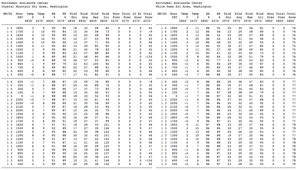
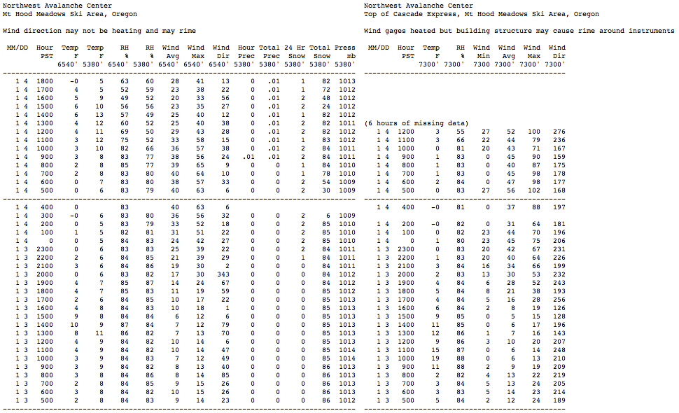
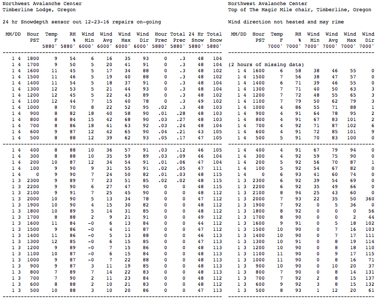
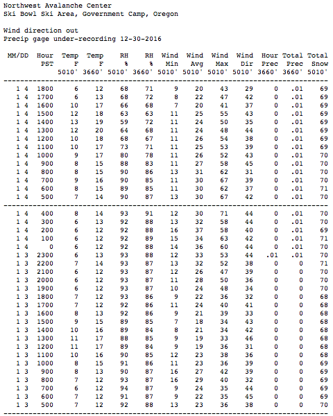
Winds were much less (albeit still quite strong) atop White Pass than atop Crystal, and similarly less at Ski Bowl versus the higher sites on Mount Hood itself. Passes farther north in Washington had even more moderate easterly winds. I also checked several RAWS and AgriMet telemetry sites located in the Columbia Gorge which have wind data, and only light to moderate winds were seen at any of those sites.
So what caused the extreme winds at Crystal and Hood?
The best tool I've found for viewing the distribution of easterly pass flow winds is the UW WRF-GFS weather model , specifically the 4km 850mb "Temp, winds, heights" plots, since 850mb is right about at the 5000 ft level, which is in the middle of the typical elevation span of such winds (3000 ft at the lowest pass, up to about 8000 ft maximum). The higher resolution 4/3 km version of the same plot is much too hard to read, and not useful. I usually use the zoomed in 4km 850mb "Western WA Temp, winds, heights" for the local winds at my common ski destinations, but the plots below all show the full state of WA in order to see winds down near Mount Hood.
As of early Tuesday morning, the plot shows moderate easterly pass flow winds of 10-20 mph (1 knot = 1.15 mph) across the Cascade Crest:

By Tuesday afternoon, winds have increased only slightly, to 20-30 mph:
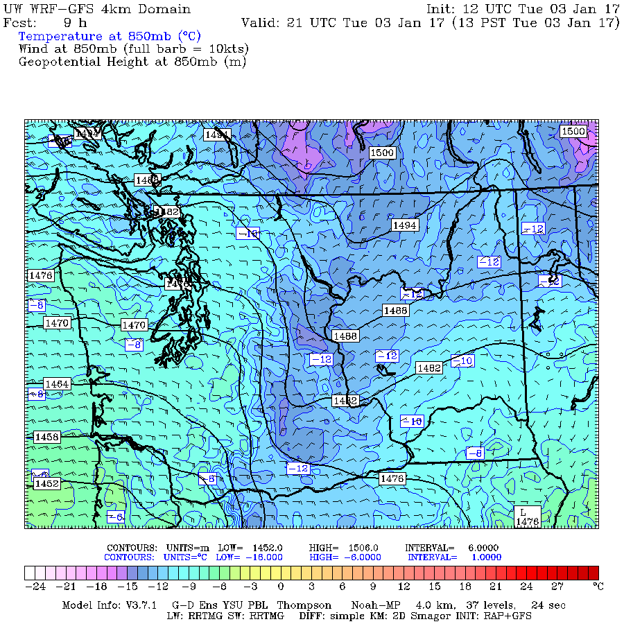
By late Tuesday evening, winds have increased substantially to 40-50 mph in spots, driven by a sharp increase in the pressure gradient as seen by the closely spaced black contours:
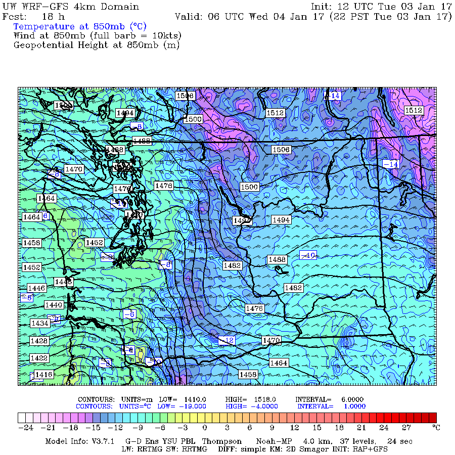
By Wednesday morning, the pressure gradient and winds have reached a maximum, with 50-60 mph winds in spots (the triangular barbs on the wind arrows are 50 knots, almost 60 mph), the same hours that the highest winds are seen in the telemetry data:
By late Wednesday afternoon (a few hours before this was written), the pressure gradient and winds have begun to diminish substantially:

By Thursday morning, the pressure gradient is forecast to vanish almost completely, and winds will diminish to near zero over the northern half of the Crest, and only 10-20 mph farther south near Oregon. Note that temperatures just east of the Crest have will also warm substantially by about 8-10 °C (almost 15-20 °F) from only 24 hours earlier:
So the link from the high winds to the subject of this thread is the cold Arctic air trapped east of the barrier of the Cascade Range. And the link to the storm system affecting California can be seen by zooming out on the same 850mb plots to show the full domain of the lower 12km resolution. By Tuesday afternoon, a low-pressure center has developed off the California coast:
By late Tuesday evening, the low has intensified greatly and moved onto the coast at the Oregon-California border, causing the sharp increase in the pressure gradient:
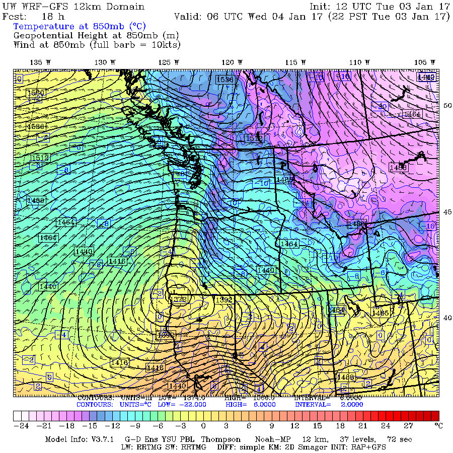
By Wednesday morning, this low has intensified slightly more and tracked northward along the coast to its most northern position, which increased the pressure gradient even more up to its maximum value:

By late Wednesday afternoon, the low has weakened substantially and even moved in a retrograde direction, back west and south of its previous position:
By Thursday morning, the low is forecast to weaken further and move SE into northern California. Over the previous 48 hours, it will have moved in a complete loop! A substantial pressure gradient and easterly pass flow winds exist only over the crest of the Oregon Cascades by that time:
Pretty interesting stuff, especially its connections to the other two major weather events of early January 2017!
Another somewhat freakish weather event event occurred today: 100+ mph easterly pass flow winds atop Crystal Mountain and at both upper NWAC sites on Mount Hood! Among the strongest easterly winds I've ever seen at those sites, although normal SW storm winds can exceed that mark a few times per year.
And the extreme easterly winds are related to both the event which is the subject of this thread, and also to the first storm system hitting California as part of their huge storm cycle (see the other thread: 10-20 ft Snowfall Predicted for CA, 02-13Jan2017!! ). I don't want to start a 3rd weather post at the same time now, so I'll just discuss the high wind event here.
First, here's the telemetry from those NWAC sites, showing the rapid increase in easterly wind starting late on the evening of January 3 and continuing until evening the next day:
Winds were much less (albeit still quite strong) atop White Pass than atop Crystal, and similarly less at Ski Bowl versus the higher sites on Mount Hood itself. Passes farther north in Washington had even more moderate easterly winds. I also checked several RAWS and AgriMet telemetry sites located in the Columbia Gorge which have wind data, and only light to moderate winds were seen at any of those sites.
So what caused the extreme winds at Crystal and Hood?
The best tool I've found for viewing the distribution of easterly pass flow winds is the UW WRF-GFS weather model , specifically the 4km 850mb "Temp, winds, heights" plots, since 850mb is right about at the 5000 ft level, which is in the middle of the typical elevation span of such winds (3000 ft at the lowest pass, up to about 8000 ft maximum). The higher resolution 4/3 km version of the same plot is much too hard to read, and not useful. I usually use the zoomed in 4km 850mb "Western WA Temp, winds, heights" for the local winds at my common ski destinations, but the plots below all show the full state of WA in order to see winds down near Mount Hood.
As of early Tuesday morning, the plot shows moderate easterly pass flow winds of 10-20 mph (1 knot = 1.15 mph) across the Cascade Crest:
By Tuesday afternoon, winds have increased only slightly, to 20-30 mph:
By late Tuesday evening, winds have increased substantially to 40-50 mph in spots, driven by a sharp increase in the pressure gradient as seen by the closely spaced black contours:
By Wednesday morning, the pressure gradient and winds have reached a maximum, with 50-60 mph winds in spots (the triangular barbs on the wind arrows are 50 knots, almost 60 mph), the same hours that the highest winds are seen in the telemetry data:
By late Wednesday afternoon (a few hours before this was written), the pressure gradient and winds have begun to diminish substantially:
By Thursday morning, the pressure gradient is forecast to vanish almost completely, and winds will diminish to near zero over the northern half of the Crest, and only 10-20 mph farther south near Oregon. Note that temperatures just east of the Crest have will also warm substantially by about 8-10 °C (almost 15-20 °F) from only 24 hours earlier:
So the link from the high winds to the subject of this thread is the cold Arctic air trapped east of the barrier of the Cascade Range. And the link to the storm system affecting California can be seen by zooming out on the same 850mb plots to show the full domain of the lower 12km resolution. By Tuesday afternoon, a low-pressure center has developed off the California coast:
By late Tuesday evening, the low has intensified greatly and moved onto the coast at the Oregon-California border, causing the sharp increase in the pressure gradient:
By Wednesday morning, this low has intensified slightly more and tracked northward along the coast to its most northern position, which increased the pressure gradient even more up to its maximum value:
By late Wednesday afternoon, the low has weakened substantially and even moved in a retrograde direction, back west and south of its previous position:
By Thursday morning, the low is forecast to weaken further and move SE into northern California. Over the previous 48 hours, it will have moved in a complete loop! A substantial pressure gradient and easterly pass flow winds exist only over the crest of the Oregon Cascades by that time:
Pretty interesting stuff, especially its connections to the other two major weather events of early January 2017!
Please Log in or Create an account to join the conversation.
- Gary_H
- [GaryJan]
-
- Offline
- Junior Member
-
Less
More
- Posts: 55
- Thank you received: 0
04 Jan 2017 20:42 #228132
by Gary_H
Replied by Gary_H on topic Re: Freak 2-3ft Snowfall at Mission & Hurricane Ridges
Outstanding analysis Amar!
My wife Jan and I experienced the Hurricane Ridge storm first hand. We do an annual New Year's Eve/New Year's Day overnight snow camping trip each year. Based on the weather forecast, we elected to stay near the base of Hurricane Hill in an area protected from both strong north and south winds. We set up camp mid-afternoon on the 31st. Weather at the time was similar to the forecast, breezy and light snow showers. The evening NOAA weather radio broadcast still predicted light snow showers tapering off by mid morning.
Snow and wind intensity increased through the night requiring periodic forays out to shovel out the tent site. Again, the morning weather broadcast indicated diminishing snowfall by mid day. Our first hand observations indicated otherwise.............. :")
We debated whether to ski out or sit tight for another night. After learning that the ski area operations team would be working until late afternoon on 1/1/17, we elected to break camp and meet up with them. The ski out from our camp to the parking area (less than 3 miles along the ridge line) took about 4 hours. Strong north winds, blowing snow and white out conditions made for slow travel. This unique weather event also created some unusual travel conditions;
1. Cornice formations on the south facing side of the ridge line, some significant in size by mid-afternoon. These forced us off of the normal travel route.
2. Wind slab formation, again on the south facing side of the ridge line.
3. On a few occasions, when forced off of the ridge line onto steeper south facing slopes, we did experience whomping and related collapse, likely indicating the 12/17/16 weak layer is still active. No evidence of shooting cracks.
4. Ski penetration was about 12" in areas with no wind affect. I agree with your estimate of snow density.
No pictures, as we were more focused on the tasks at hand.
Again, thanks for your in depth analysis,
Gary
My wife Jan and I experienced the Hurricane Ridge storm first hand. We do an annual New Year's Eve/New Year's Day overnight snow camping trip each year. Based on the weather forecast, we elected to stay near the base of Hurricane Hill in an area protected from both strong north and south winds. We set up camp mid-afternoon on the 31st. Weather at the time was similar to the forecast, breezy and light snow showers. The evening NOAA weather radio broadcast still predicted light snow showers tapering off by mid morning.
Snow and wind intensity increased through the night requiring periodic forays out to shovel out the tent site. Again, the morning weather broadcast indicated diminishing snowfall by mid day. Our first hand observations indicated otherwise.............. :
We debated whether to ski out or sit tight for another night. After learning that the ski area operations team would be working until late afternoon on 1/1/17, we elected to break camp and meet up with them. The ski out from our camp to the parking area (less than 3 miles along the ridge line) took about 4 hours. Strong north winds, blowing snow and white out conditions made for slow travel. This unique weather event also created some unusual travel conditions;
1. Cornice formations on the south facing side of the ridge line, some significant in size by mid-afternoon. These forced us off of the normal travel route.
2. Wind slab formation, again on the south facing side of the ridge line.
3. On a few occasions, when forced off of the ridge line onto steeper south facing slopes, we did experience whomping and related collapse, likely indicating the 12/17/16 weak layer is still active. No evidence of shooting cracks.
4. Ski penetration was about 12" in areas with no wind affect. I agree with your estimate of snow density.
No pictures, as we were more focused on the tasks at hand.
Again, thanks for your in depth analysis,
Gary
Please Log in or Create an account to join the conversation.