January 1, 2017, Snoqualmie Pass
1/1/17
WA Snoqualmie Pass
4115
10
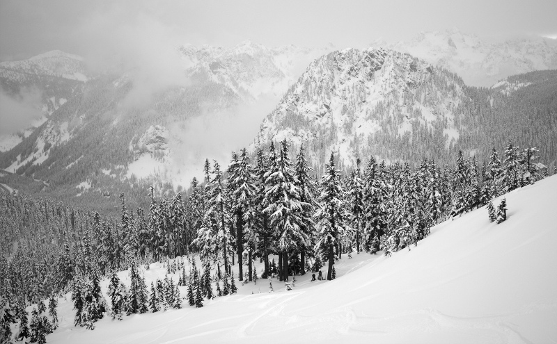
Kendall trap being the thin stand of trees lookers right of the open slope below Kendall where Monty was found? I can't tell you how many times I've been up in those and figured it was fairly safe. Granted we are usually first up there so nobody is above but still, it shows how slides can happen down to the top part of those trees.
I think he meant as things get tracked the action gradually shifts skier's right into and below more hazardous terrain.
Gotcha, we never go over there, that part scares me.
Natefred's got it -- the nature of Kendall's terrain is that protected terrain moves smoothly to wind-affected and more-alpine terrain.
On Kendall, it is easy to convince yourself of snow quality and stability in one spot and use that information to justify moving into more-aggressive terrain without noting that snowpack is subject to completely different influences, especially wind and wind-loading. The distance over which the snowpack can make a profound change can be as small as tens of meters. It is my belief that, in both recent Kendall accidents, the movement to more-exposed terrain based upon less-relevant, but comforting, information was a contributing factor.
The increasing density of skiers on Kendall and elsewhere means that skiers above and below each of us, and the decisions they're making, must be considered when making route choices. I'm now extremely gunshy about skiers above, which has constrained my terrain choices further throughout the Cascades.
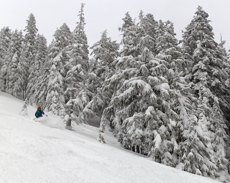
I feel the pull into riskier terrain almost every time I ski, which is why I'm so ardent about explicitly ruling out terrain with the AvySticker (or on a piece of duct tape; just get it where you can see it). On Sunday, the snow was so good, we pushed right up against, but did not cross, our ruled-out threshold for the day.
I hope to write up a longer-form bit about the 'Trap', but wanted to get the concept out there for others to consider. Thanks for taking the bait, haggis :).
On Kendall, it is easy to convince yourself of snow quality and stability in one spot and use that information to justify moving into more-aggressive terrain without noting that snowpack is subject to completely different influences, especially wind and wind-loading. The distance over which the snowpack can make a profound change can be as small as tens of meters. It is my belief that, in both recent Kendall accidents, the movement to more-exposed terrain based upon less-relevant, but comforting, information was a contributing factor.
The increasing density of skiers on Kendall and elsewhere means that skiers above and below each of us, and the decisions they're making, must be considered when making route choices. I'm now extremely gunshy about skiers above, which has constrained my terrain choices further throughout the Cascades.
I feel the pull into riskier terrain almost every time I ski, which is why I'm so ardent about explicitly ruling out terrain with the AvySticker (or on a piece of duct tape; just get it where you can see it). On Sunday, the snow was so good, we pushed right up against, but did not cross, our ruled-out threshold for the day.
I hope to write up a longer-form bit about the 'Trap', but wanted to get the concept out there for others to consider. Thanks for taking the bait, haggis :).
+1 on the longer form bit. Would also love to see a diagram/map along with it, as I'm not very familiar with that area.
Regarding the trees on the upper west slopes of Kendall: they may offer less protection than one might expect. Many of them are flagged from slide activity. The trees may offer some protection, but they also amplify the consequence of any slide that manages to reach a skier.
My perspective on the slide-resistance of the Kendall Trees as a storm-skiing venue in general changed substantially when I learned that the "main slide path" was formed in the mid-nineties. Most of us are older than that slide path.
My perspective on the slide-resistance of the Kendall Trees as a storm-skiing venue in general changed substantially when I learned that the "main slide path" was formed in the mid-nineties. Most of us are older than that slide path.
I think it's very important for folks to know where Monty was found, well into one of those upper tree bands. Whether he was skinning up above or the slide hit him while he was in the trees, we'll never know, but the Kendall terrain can push slides well into "protected" terrain that people use to skin up the slopes.
I felt echoes of that same feeling of safety in Bullion last week, touring through the thick trees where, 9 years ago, three snowboarders hunkered down for the night in apparent safety from the terrain above. Know what's above you.
I felt echoes of that same feeling of safety in Bullion last week, touring through the thick trees where, 9 years ago, three snowboarders hunkered down for the night in apparent safety from the terrain above. Know what's above you.
It sounds like Charlie revised his earlier answer to include most of the ridge... I agree.
Trap is a good term for it. We can easily be lulled by the relative safety and goodness of the Kendall glades. But lurking right above that is the Kendall ridge-line, both steeper and more convoluted (attractive!) in terms of terrain and subject to much more radical weather events, i.e. the formation of slicker running surfaces paired with exponential wind loading. Much like Charlie described.
I think both Haggis and Natefred are right; in my estimation and experience the whole ridge-line can be potentially dangerous. Especially the ridge-line right above the glades because there's more sense of security there, and more people there...
And more trees to get raked through if it does go. I've seen that whole ridge-line release right down into the trees, right where the main skin track usually goes up.

Some of you may recognize this rock, dividing two of the upper 'bowls'.
From 04.13.2013.

looking south, you can see the skin track along the upper tree boundary
Putting this up for general knowledge and because it's good to refresh our memories; memory is fallible. I know mine is.
are words of wisdom.
I will also add: A skin track does not equate safety.
Think before following a fresh skin track into potentially hazardous terrain, especially if you can't see who is above you... or evidence of down tracks.
If there is any instability in the snow-pack, having people above you impacting the slope just made it even more unstable.
Trap is a good term for it. We can easily be lulled by the relative safety and goodness of the Kendall glades. But lurking right above that is the Kendall ridge-line, both steeper and more convoluted (attractive!) in terms of terrain and subject to much more radical weather events, i.e. the formation of slicker running surfaces paired with exponential wind loading. Much like Charlie described.
I think both Haggis and Natefred are right; in my estimation and experience the whole ridge-line can be potentially dangerous. Especially the ridge-line right above the glades because there's more sense of security there, and more people there...
And more trees to get raked through if it does go. I've seen that whole ridge-line release right down into the trees, right where the main skin track usually goes up.
Some of you may recognize this rock, dividing two of the upper 'bowls'.
From 04.13.2013.
looking south, you can see the skin track along the upper tree boundary
Putting this up for general knowledge and because it's good to refresh our memories; memory is fallible. I know mine is.
author=Marcus link=topic=37458.msg151866#msg151866 date=1483470416]
Know what's above you.
are words of wisdom.
I will also add: A skin track does not equate safety.
Think before following a fresh skin track into potentially hazardous terrain, especially if you can't see who is above you... or evidence of down tracks.
If there is any instability in the snow-pack, having people above you impacting the slope just made it even more unstable.
author=cumulus link=topic=37458.msg151872#msg151872 date=1483476240]I will also add: A skin track does not equate safety.
So true. My wife described to me the decision making that she and her crew went through on Sunday, touring up to Bryant Col. A track was in, but they just didn't like the feel of the terrain, so they pulled the plugged, bailed around Pineapple and continued on the circumnav, adding a good chunk of climbing and distance to the tour. I was pretty impressed to hear it and I always wonder if I'd have made the same choice or just followed with my head down.
author=Marcus link=topic=37458.msg151889#msg151889 date=1483486769]
So true. My wife described to me the decision making that she and her crew went through on Sunday, touring up to Bryant Col. A track was in, but they just didn't like the feel of the terrain, so they pulled the plugged, bailed around Pineapple and continued on the circumnav, adding a good chunk of climbing and distance to the tour. I was pretty impressed to hear it and I always wonder if I'd have made the same choice or just followed with my head down.
A few more details why we took the long way around... yup, there was a skin track going over Bryant already Sunday AM, but as we approached clouds rapidly obscured our view- viz was probably 50ft...like standing in a snowglobe - it was impossible to tell where the track went unless you were right on it. On the skin up, we saw the thin layer of graupel mixed in with the new snow had pooled on lower angle terrain below steeps into a thick layer of ball bearings with new snow on top, so we were concerned that the skin track wrapping below the cliffs above would have similar pools of buried graupel. The final straw was as two of us futzed about in front, the others heard active sluffing coming from the cliffy terrain above obscured in the clouds...those were enough warnings for us to collectively agree lets keep trucking on the safer and longer route around. I was very glad that party members spoke up and we were all agreeable to tweak the tour accordingly. Plenty of folks obviously climbed to Bryant Col that day and the next day and had no issues at all....we just weren't feeling it.
Reply to this TR
Please login first: