Nov 29, 2016, Mt Rainier, Muir Solitude + Powder!
11/29/16
WA Cascades West Slopes South (Mt Rainier)
16255
9
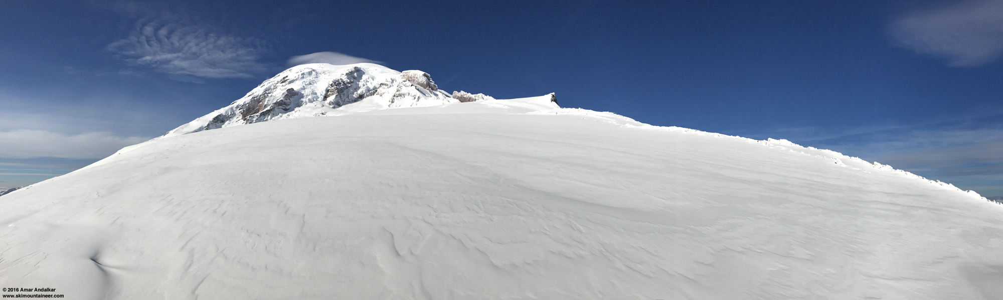
Nowadays, people who meet me at events or recognize me on ski days in the mountains often ask me why I don't write trip reports any more. I'm not sure of the answer, given that I used to post trip reports here quite frequently in previous years, and given that 2016 has been one of my best ski years. But somehow I haven't written almost any trip reports this year, for unknown reasons really. Just this one TR for an amazing 8-day trip in May (![]() http://www.skimountaineer.com/TR/Images2016/RainierMuirUntrackedPano3000-29Nov2016.jpg" />
http://www.skimountaineer.com/TR/Images2016/RainierMuirUntrackedPano3000-29Nov2016.jpg" />
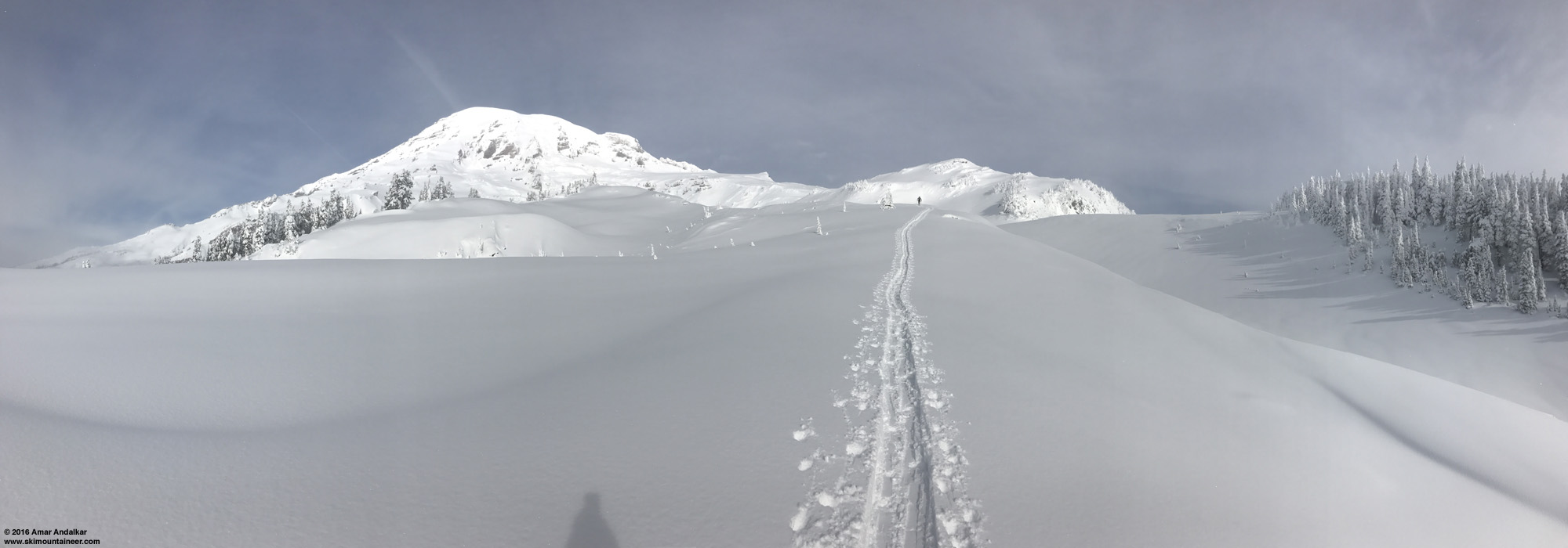
Untracked powder on the Muir Snowfield. (iPhone 7 Plus panorama spanning about 240°, click for triple-size version)
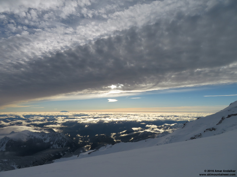
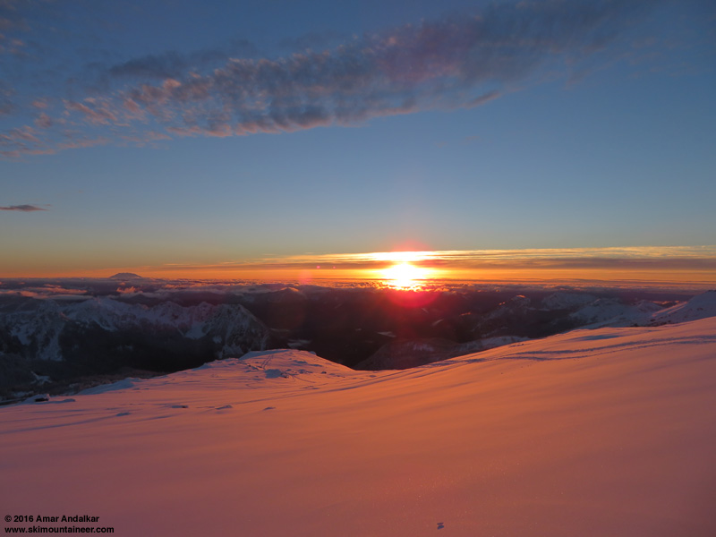
Took advantage of an unexpectedly fine weather window on Tuesday, and skied from Camp Muir to the parking lot in nearly 100% powder conditions. Just 4-6" of silky smooth dense powder atop a thick base of several feet of concrete which plastered over almost all the rocks, and mostly not wind-affected at all either, other than a short section from 9700-9200 ft. No avalanche activity seen anywhere along the route. Pretty rare to find top-to-bottom powder on that route, although surprisingly it was very similar only 12 days earlier too the last time I'd been up to Muir. Both trips probably rank among my top 10 or 15 winter-conditions Muir ski descents over the last 20 years, out of now 280 times skiing from Camp Muir since June 1996, including 101 times during the months of November-March when winter conditions are most likely (although I've often found corn up there even during the wintry months too). So the conditions really were exceptional by some objective standard.
The forecast was a bit uncertain this time: the highly reliable cloud forecast had indicated mostly sunny skies at upper elevations with low clouds below, with a thick band of high clouds passing overhead after 1pm but then clearing out completely by 4pm:
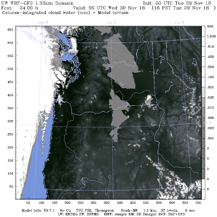
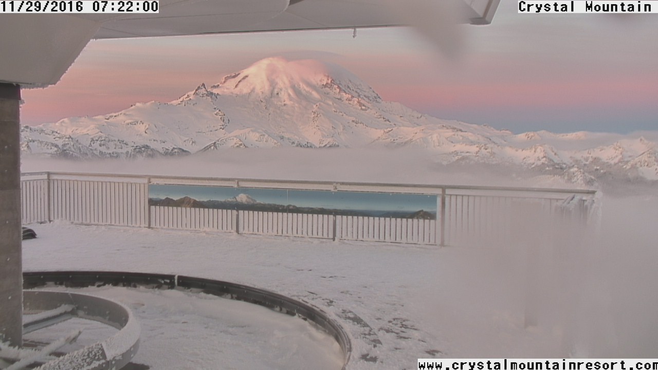
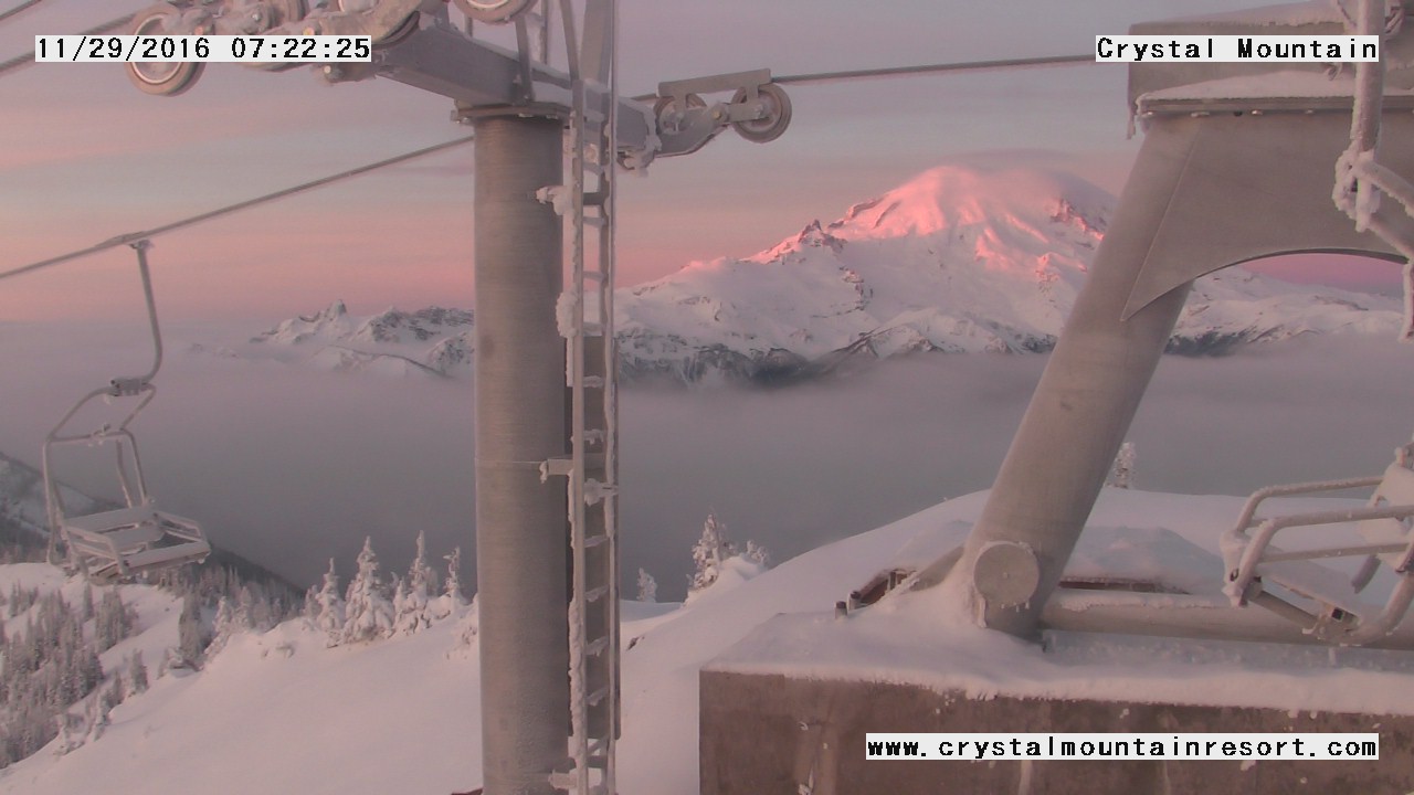
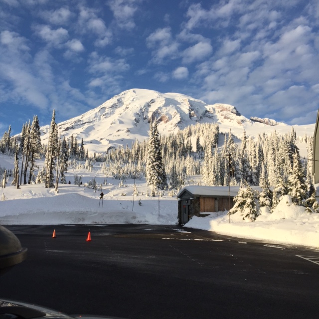
Winds at the 700 mb level near 10000 ft were also forecast to decrease during the day to only 10 mph or so. I decided to take a chance on the UW model's prediction and head high instead of just going to Crystal. But I figured I could get a late start and check the first dawn webcam views before leaving Seattle, since with new snow overnight the Longmire gate was unlikely to open at 9am sharp, with 10am more likely. The morning webcam from Paradise was totally socked in, with light snow still falling in the parking lot, but both of the cams atop Crystal Mountain which occasionally point towards Rainier (gondola upper terminal and the new cam at the top of Chair 6) showed that the UW model had been correct:
Time to get ready and hit the road! The park's 7:30am Twitter update unexpectedly said the gate would open at 9am, but I would be leaving far too late to make it for that, at 8am from Seattle. Turns out the gate did open on time despite their having to plow 5" of new snow overnight (good to see that!), but I passed through it at 10am and wasn't skinning until 10:50am, in a mix of partial sunshine and light snow.
Despite the late start, only a handful of skiers were ahead of me and a few more behind me, very deserted even for a midweek day. Of course, now suddenly there are lots of other locations for accessible ski touring after the last week of heavy snowfall down to 4000 ft, even 3000 ft. Broke out above the cloud deck by 6100 ft, to a glorious vista of smooth powder covering everything.
Breaking out above the clouds near 6100 ft. (iPhone 7 Plus panorama, click for double-size version)
Easy skinning up Panorama Face on 4-6" new well-bonded to a deep base, with ski crampons not even needed. The previous time 12 days earlier, the summer trail route was still far preferable for skinning and skiing, compared to the very thin coverage up Pan Face.
![]() http://www.skimountaineer.com/TR/Images2016/RainierPanFaceCloudsPano2000-29Nov2016.jpg" />
http://www.skimountaineer.com/TR/Images2016/RainierPanFaceCloudsPano2000-29Nov2016.jpg" />
Very wintry panorama of Rainier and Panorama Point. (click for double-size version)
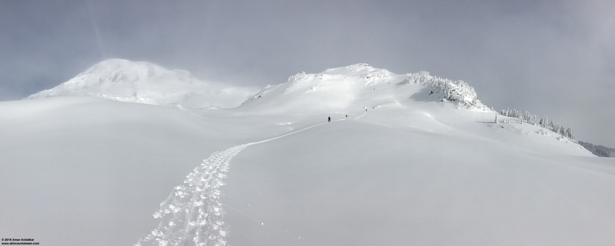
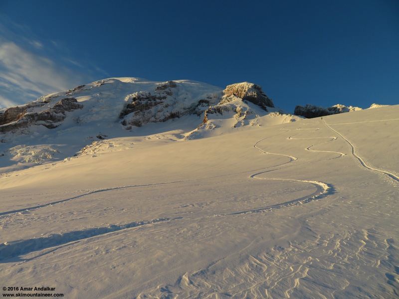
The first 10-15 ft high snow roll atop Pan Point was a different story, though, with its wind-sculpted face oversteepened to 50-60° and variable amounts of 6-36" deep powder making it very hard to put in a skintrack as it sluffed down the steep face. The other 4 ahead of me were all switching to booting, but even that was no easy task, and soon they were making 4 separate boot packs up the roll (?!?!) in an attempt to find the path of least resistance. I really should have put on the ski crampons (for their anchoring effect) and somehow forged a skin track up it, at the right end where there's a partial ramp, but figured it would be quicker to just boot in one of the other tracks. NOT! Not at all! I tried climbing up at the left end, gave up after wallowing in the previous bootpack for a couple minutes, then skinned back to the right end and tried one of those tracks instead. Ugh! It took almost 10 minutes of unpleasant effort to climb those 10 ft, even in a previous bootpack. Just miserable. It might be the single worst spot of difficulty I've had during any of my Muir ascents! Just reinforcing my longstanding belief that the skis belong on your feet, not in your hands, and that it's almost always best to skin if it's even remotely possible to do so without serious risk. The slope was sluffing but not slabbing in any way, and the runout is flat, so trying to skin here involved little risk this day.
![]() http://www.skimountaineer.com/TR/Images2016/RainierPanPointRollPano2000-29Nov2016.jpg" />
http://www.skimountaineer.com/TR/Images2016/RainierPanPointRollPano2000-29Nov2016.jpg" />
Quandary at the Pan Point roll. (click for double-size version)
Anyway, no more issues after that spot, the next roll and the last steep slope near 7000 ft were easy skinning to reach the rightward traverse of the winter route. As we cruised along, I glanced to my right and was amazed by this sight:
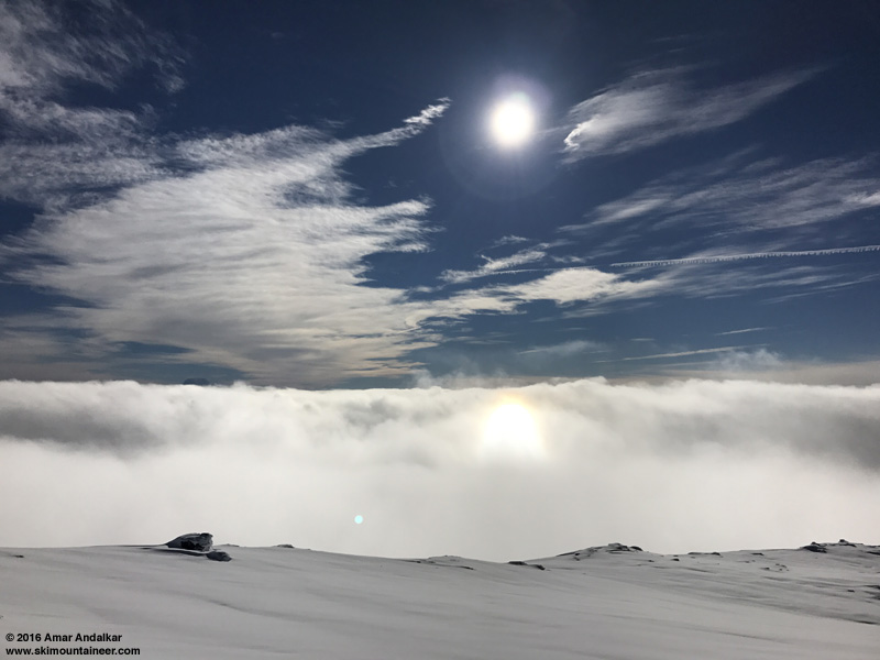
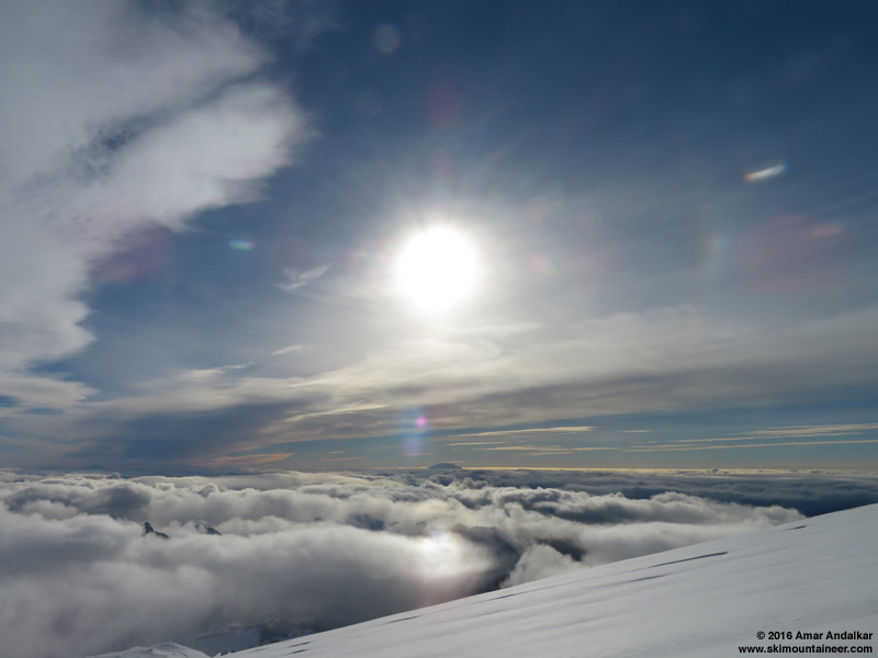
12:30pm: First views of the very unusual solar halo in the clouds below. (iPhone 7 Plus pic)
I'm fascinated by solar halos, and have written about them extensively in several previous trip reports. This one I assumed was a "subsun", a bright reflection of the sun from ice crystals in a cloud deck located beneath the observer. It's a halo that can only be seen from elevated locations, and I've seen it a few times before, even seen it on the 7th Heaven webcam at Whistler (see TAY post:![]() http://www.skimountaineer.com/TR/Images2016/RainierCloudsHaloPano3000-29Nov2016.jpg" />
http://www.skimountaineer.com/TR/Images2016/RainierCloudsHaloPano3000-29Nov2016.jpg" />
12:45pm: Panorama spanning about 260° along the winter route, with the solar halo at left. (click for triple-size version)
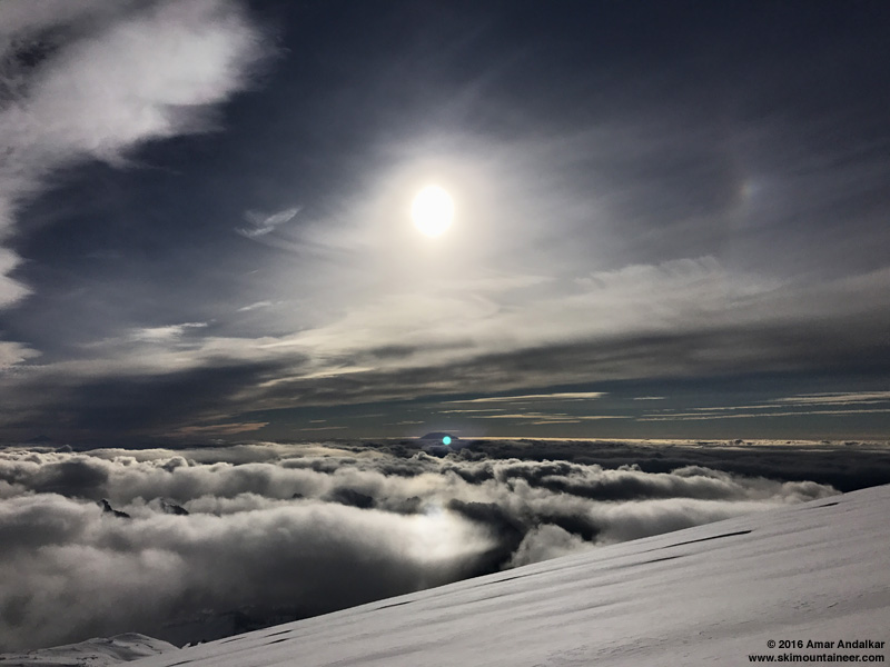
After I got home, I decided to do some research, and discovered that this halo was in fact a new one that I had never seen before (in this form): the lower tangent arc! That halo can occur as part of the same group of halos which produces the subsun, but it's located above the sunsun and is a lovely rainbow-colored downward-facing arc, just as I had seen. The excellent Atmospheric Optics website has several pages with useful info and photos, see for a nifty user-changeable simulated image. As you can see by mousing over the slider, the sharply-curved arc seen in these photos only occurs for a solar elevation of about 20°, with the halo located just below the horizon:
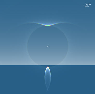
This almost exactly matches the halo seen in my photos. The maximum solar elevation this time of year is only 21° at Mount Rainier, which occurs at solar noon of 11:55am PST (see my
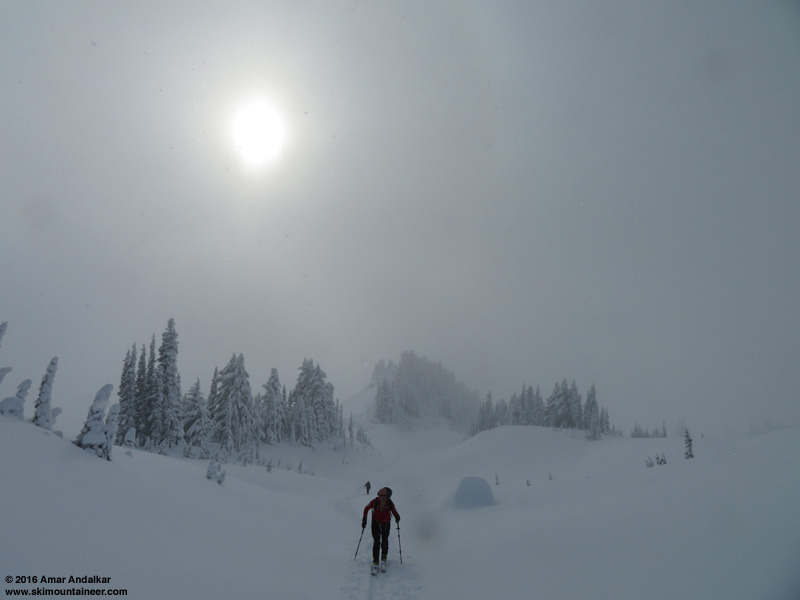
Kurt Hummel breaking trail up the untracked powder of the Muir Snowfield.
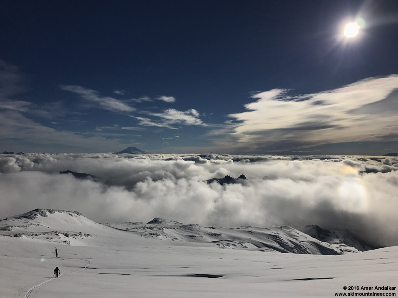
1:25pm: Still an awesome lower tangent arc an hour later from above 8000 ft on the Muir Snowfield. (iPhone 7 Plus pic)
I unexpectedly passed all the others by 8000 ft, and soon I was skinning up all alone on a gleaming smooth untracked slope.
![]() http://www.skimountaineer.com/TR/Images2016/RainierMuirUntrackedPano2000-29Nov2016.jpg" />
http://www.skimountaineer.com/TR/Images2016/RainierMuirUntrackedPano2000-29Nov2016.jpg" />
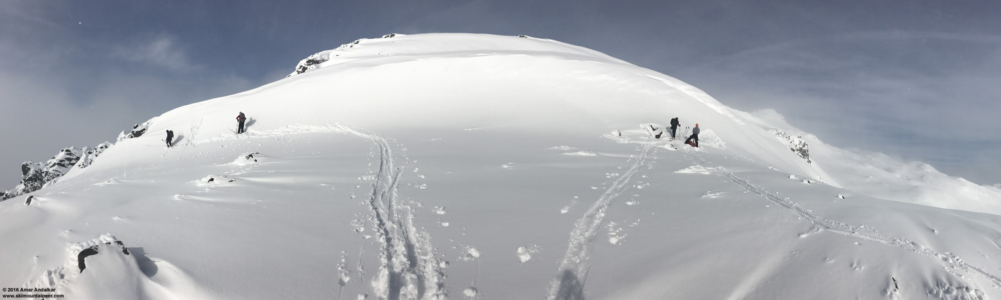
An untracked canvas awaits my skin track. So stoked! Note the incipient lenticular cloud atop the summit. (click for double-size version)
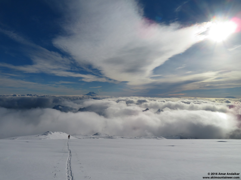
Breaking trail up the untracked powder of the Muir Snowfield, looking back at Goat Rocks, Mount Adams, Mount Hood, and Mount Saint Helens in the distance (left to right).
As 2pm approached and the sun dropped lower, thin high clouds overhead caused the halo display to grow to include the common 22° circular halo around the sun, with the also-common parhelion (sundog) superimposed just outside that arc. See
1:45pm: The halo display grows to include the 22° halo, seen as a partial arc at right, with a sundog superimposed just outside that arc. (Canon SX720 HS pic)
Same view. (iPhone 7 Plus pic)
As predicted by the UW model, a thick band of high clouds soon blotted out the sun, and temperatures dropped quickly, with an extra hoody immediately going on. (See the Muir telemetry below, which shows a drop from 32 °F to 24°F between 2-3pm, as solar radiation dropped from over 400 watts per square meter to only 170.) Breaking trail up the Snowfield still felt like an easy cruise, but I realized by the altimeter watch that I wasn't moving very fast, barely over 1000 ft/hr as I continued above 9000 ft. Not a big deal as I wasn't in a rush this day, but I just can't be fast at my current excessive weight, despite very good underlying fitness.
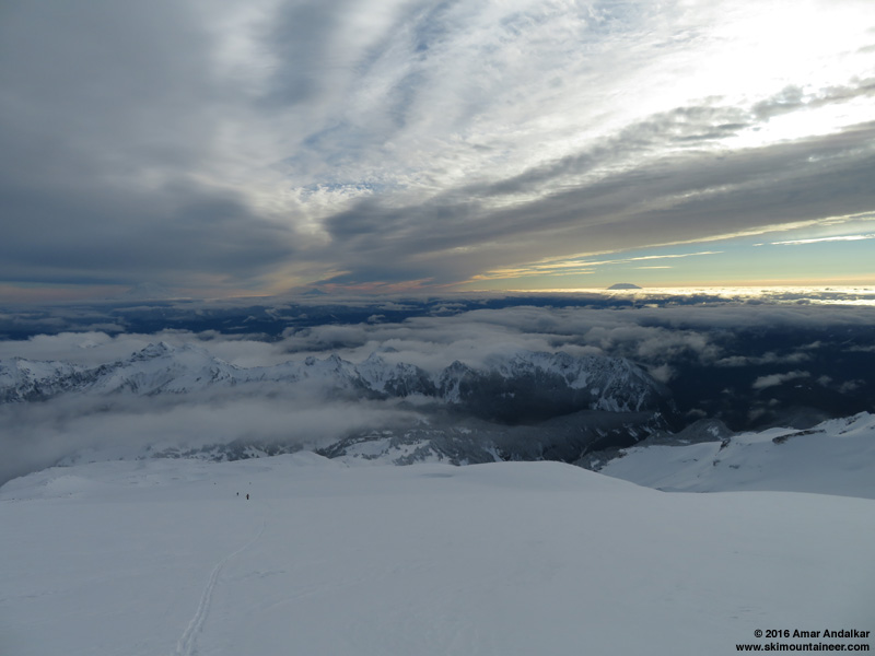
2:45pm: High clouds blotting out the sun, but hope for a brighter future is visible at far right.
I looked back at the others trailing me, and was surprised to see that all of them were switching over, most by 9000 ft and one around 9300 ft, and soon skiing down well before 3pm. Maybe they were worried about the thickening clouds overhead? But I knew, given both the UW model forecast and my own observations of approaching conditions to the SW, that it would soon be completely sunny and glorious once again, as the sun continued to drop lower and the thick high cloud band continued to drift slowly eastward. There was no reason for me to bail.
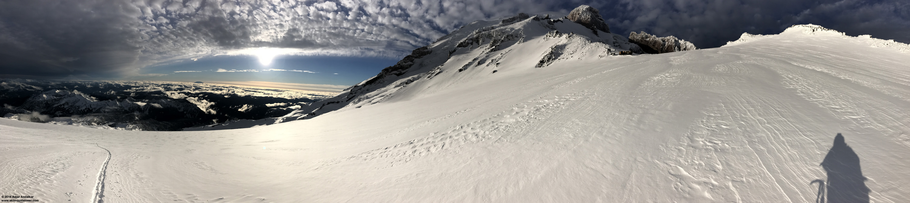
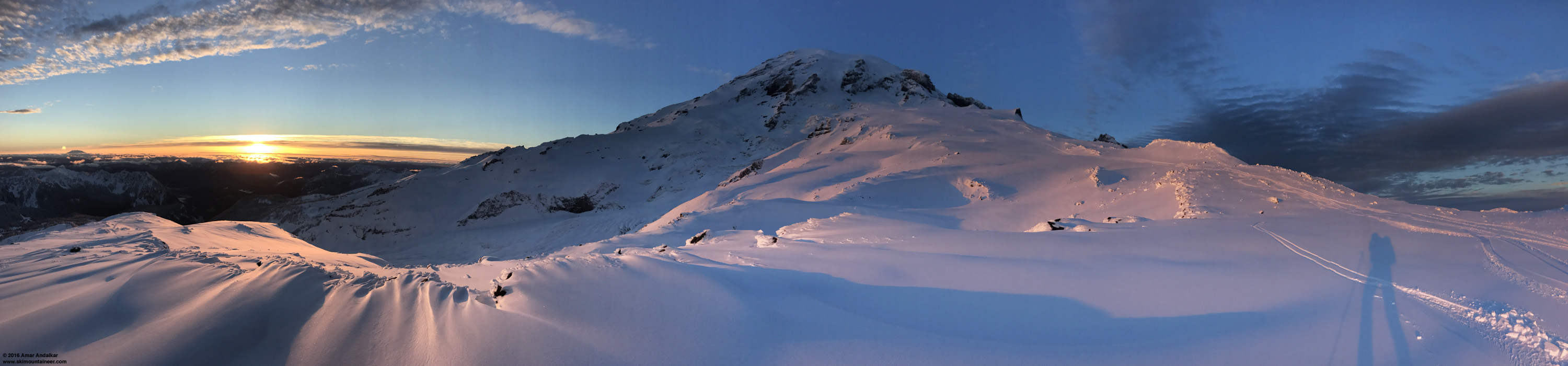
3:00pm: Here comes the sun ...
After enduring an hour of semi-darkness, it was truly glorious when the sun finally began to drop below the shifting high cloud deck, like a strange new dawn returning from below. Intense slanting sunlight, combined with winds that were almost calm at about 0-2 mph, rapidly warmed things back up to a comfortable temperature.
![]() http://www.skimountaineer.com/TR/Images2016/RainierMuirHighCloudsSunPano3000-29Nov2016.jpg" />
http://www.skimountaineer.com/TR/Images2016/RainierMuirHighCloudsSunPano3000-29Nov2016.jpg" />
3:20pm: Sun, sun, sun, here it comes! Panorama spanning about 220° along the Muir Snowfield near 9800 ft. (click for triple-size version)
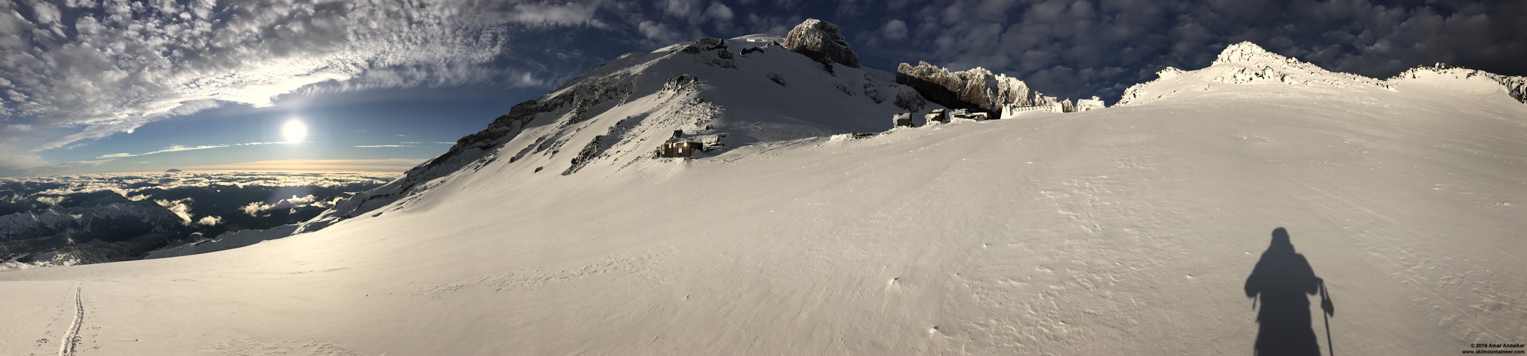
![]() http://www.skimountaineer.com/TR/Images2016/RainierMuirAlmostTherePano3000-29Nov2016.jpg" />
http://www.skimountaineer.com/TR/Images2016/RainierMuirAlmostTherePano3000-29Nov2016.jpg" />
3:30pm: Almost there, only a couple minutes from Camp Muir. Panorama spanning about 220° near 10000 ft. (click for triple-size version)
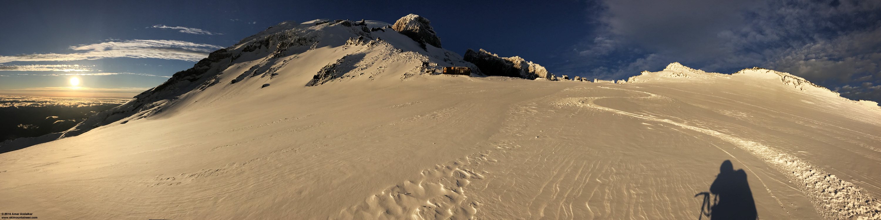
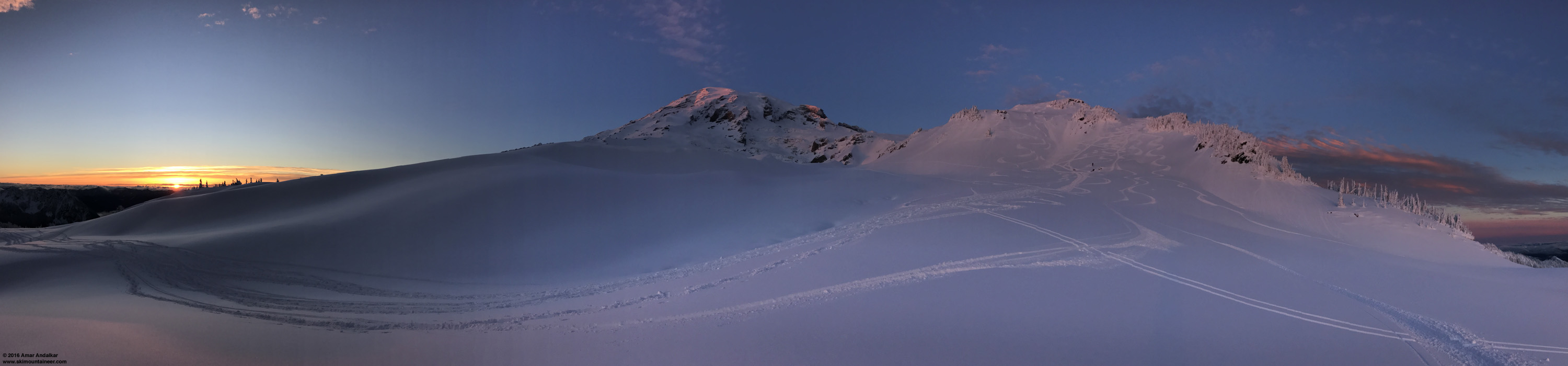
At Camp Muir itself, there was a bit of a SW wind, maybe 5-15mph. So I went to the far right end of camp and the most wind-protected but still brightly sunlit spot, located behind a wind lip at the new (not yet completed) restroom building.
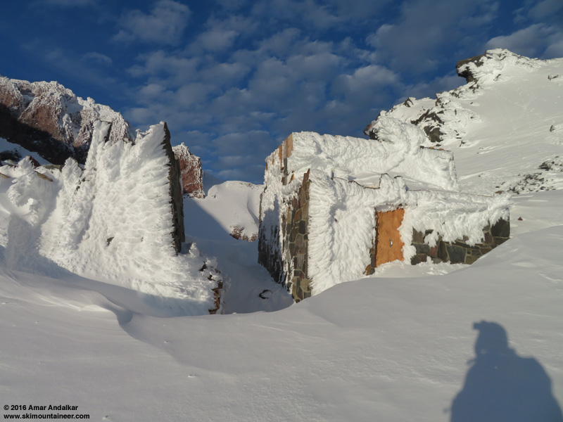
Lovely rime formations adorn the Muir public shelter at left, the new restroom building at right. Lovely ski slope below Cathedral Gap at center.
![]() http://www.skimountaineer.com/TR/Images2016/RainierMuirSkinTrackPano2000-29Nov2016.jpg" />
http://www.skimountaineer.com/TR/Images2016/RainierMuirSkinTrackPano2000-29Nov2016.jpg" />
3:50pm: Looking out from the wind lip changeover spot, just about ready to ski back down the Muir Snowfield. (click for double-size version)
The ski down was glorious, as expected given the conditions while skinning up, and also the cold temps + high elevation to preserve the powder despite full sun most of the day. Silky smooth fast powder. Not very deep, but it didn't need to be.

![]() http://www.skimountaineer.com/TR/Images2016/RainierMuirSkiTrackPano3000-29Nov2016.jpg" />
http://www.skimountaineer.com/TR/Images2016/RainierMuirSkiTrackPano3000-29Nov2016.jpg" />
Silky smooth fast powder. Panorama spanning about 240° near 9900 ft. (click for triple-size version)
Also as expected from the skin up, the most variable conditions were from about 9700-9200 ft where a bit of wind had affected the new snow as it fell, but even on that part the conditions were not bad at all, with minimal breakable crust. But at 4pm I was surprised to see another skier still skinning up at 9300 ft. I mentioned to him that he would miss the 5pm gate closing time for sure if he continued up, given that he was still 800 ft from Muir, but he seemed unconcerned and went on his way.
Continued in next post, exceeded 20,000 character limit . . .
Untracked powder on the Muir Snowfield. (iPhone 7 Plus panorama spanning about 240°, click for triple-size version)
Took advantage of an unexpectedly fine weather window on Tuesday, and skied from Camp Muir to the parking lot in nearly 100% powder conditions. Just 4-6" of silky smooth dense powder atop a thick base of several feet of concrete which plastered over almost all the rocks, and mostly not wind-affected at all either, other than a short section from 9700-9200 ft. No avalanche activity seen anywhere along the route. Pretty rare to find top-to-bottom powder on that route, although surprisingly it was very similar only 12 days earlier too the last time I'd been up to Muir. Both trips probably rank among my top 10 or 15 winter-conditions Muir ski descents over the last 20 years, out of now 280 times skiing from Camp Muir since June 1996, including 101 times during the months of November-March when winter conditions are most likely (although I've often found corn up there even during the wintry months too). So the conditions really were exceptional by some objective standard.
The forecast was a bit uncertain this time: the highly reliable cloud forecast had indicated mostly sunny skies at upper elevations with low clouds below, with a thick band of high clouds passing overhead after 1pm but then clearing out completely by 4pm:
Winds at the 700 mb level near 10000 ft were also forecast to decrease during the day to only 10 mph or so. I decided to take a chance on the UW model's prediction and head high instead of just going to Crystal. But I figured I could get a late start and check the first dawn webcam views before leaving Seattle, since with new snow overnight the Longmire gate was unlikely to open at 9am sharp, with 10am more likely. The morning webcam from Paradise was totally socked in, with light snow still falling in the parking lot, but both of the cams atop Crystal Mountain which occasionally point towards Rainier (gondola upper terminal and the new cam at the top of Chair 6) showed that the UW model had been correct:
Time to get ready and hit the road! The park's 7:30am Twitter update unexpectedly said the gate would open at 9am, but I would be leaving far too late to make it for that, at 8am from Seattle. Turns out the gate did open on time despite their having to plow 5" of new snow overnight (good to see that!), but I passed through it at 10am and wasn't skinning until 10:50am, in a mix of partial sunshine and light snow.
Despite the late start, only a handful of skiers were ahead of me and a few more behind me, very deserted even for a midweek day. Of course, now suddenly there are lots of other locations for accessible ski touring after the last week of heavy snowfall down to 4000 ft, even 3000 ft. Broke out above the cloud deck by 6100 ft, to a glorious vista of smooth powder covering everything.
Breaking out above the clouds near 6100 ft. (iPhone 7 Plus panorama, click for double-size version)
Easy skinning up Panorama Face on 4-6" new well-bonded to a deep base, with ski crampons not even needed. The previous time 12 days earlier, the summer trail route was still far preferable for skinning and skiing, compared to the very thin coverage up Pan Face.
 http://www.skimountaineer.com/TR/Images2016/RainierPanFaceCloudsPano2000-29Nov2016.jpg" />
Very wintry panorama of Rainier and Panorama Point. (click for double-size version)
The first 10-15 ft high snow roll atop Pan Point was a different story, though, with its wind-sculpted face oversteepened to 50-60° and variable amounts of 6-36" deep powder making it very hard to put in a skintrack as it sluffed down the steep face. The other 4 ahead of me were all switching to booting, but even that was no easy task, and soon they were making 4 separate boot packs up the roll (?!?!) in an attempt to find the path of least resistance. I really should have put on the ski crampons (for their anchoring effect) and somehow forged a skin track up it, at the right end where there's a partial ramp, but figured it would be quicker to just boot in one of the other tracks. NOT! Not at all! I tried climbing up at the left end, gave up after wallowing in the previous bootpack for a couple minutes, then skinned back to the right end and tried one of those tracks instead. Ugh! It took almost 10 minutes of unpleasant effort to climb those 10 ft, even in a previous bootpack. Just miserable. It might be the single worst spot of difficulty I've had during any of my Muir ascents! Just reinforcing my longstanding belief that the skis belong on your feet, not in your hands, and that it's almost always best to skin if it's even remotely possible to do so without serious risk. The slope was sluffing but not slabbing in any way, and the runout is flat, so trying to skin here involved little risk this day.
 http://www.skimountaineer.com/TR/Images2016/RainierPanPointRollPano2000-29Nov2016.jpg" />
Quandary at the Pan Point roll. (click for double-size version)
Anyway, no more issues after that spot, the next roll and the last steep slope near 7000 ft were easy skinning to reach the rightward traverse of the winter route. As we cruised along, I glanced to my right and was amazed by this sight:
12:30pm: First views of the very unusual solar halo in the clouds below. (iPhone 7 Plus pic)
I'm fascinated by solar halos, and have written about them extensively in several previous trip reports. This one I assumed was a "subsun", a bright reflection of the sun from ice crystals in a cloud deck located beneath the observer. It's a halo that can only be seen from elevated locations, and I've seen it a few times before, even seen it on the 7th Heaven webcam at Whistler (see TAY post:
12:45pm: Panorama spanning about 260° along the winter route, with the solar halo at left. (click for triple-size version)
After I got home, I decided to do some research, and discovered that this halo was in fact a new one that I had never seen before (in this form): the lower tangent arc! That halo can occur as part of the same group of halos which produces the subsun, but it's located above the sunsun and is a lovely rainbow-colored downward-facing arc, just as I had seen. The excellent Atmospheric Optics website has several pages with useful info and photos, see for a nifty user-changeable simulated image. As you can see by mousing over the slider, the sharply-curved arc seen in these photos only occurs for a solar elevation of about 20°, with the halo located just below the horizon:
This almost exactly matches the halo seen in my photos. The maximum solar elevation this time of year is only 21° at Mount Rainier, which occurs at solar noon of 11:55am PST (see my
Kurt Hummel breaking trail up the untracked powder of the Muir Snowfield.
1:25pm: Still an awesome lower tangent arc an hour later from above 8000 ft on the Muir Snowfield. (iPhone 7 Plus pic)
I unexpectedly passed all the others by 8000 ft, and soon I was skinning up all alone on a gleaming smooth untracked slope.
 http://www.skimountaineer.com/TR/Images2016/RainierMuirUntrackedPano2000-29Nov2016.jpg" />
An untracked canvas awaits my skin track. So stoked! Note the incipient lenticular cloud atop the summit. (click for double-size version)
Breaking trail up the untracked powder of the Muir Snowfield, looking back at Goat Rocks, Mount Adams, Mount Hood, and Mount Saint Helens in the distance (left to right).
As 2pm approached and the sun dropped lower, thin high clouds overhead caused the halo display to grow to include the common 22° circular halo around the sun, with the also-common parhelion (sundog) superimposed just outside that arc. See
1:45pm: The halo display grows to include the 22° halo, seen as a partial arc at right, with a sundog superimposed just outside that arc. (Canon SX720 HS pic)
Same view. (iPhone 7 Plus pic)
As predicted by the UW model, a thick band of high clouds soon blotted out the sun, and temperatures dropped quickly, with an extra hoody immediately going on. (See the Muir telemetry below, which shows a drop from 32 °F to 24°F between 2-3pm, as solar radiation dropped from over 400 watts per square meter to only 170.) Breaking trail up the Snowfield still felt like an easy cruise, but I realized by the altimeter watch that I wasn't moving very fast, barely over 1000 ft/hr as I continued above 9000 ft. Not a big deal as I wasn't in a rush this day, but I just can't be fast at my current excessive weight, despite very good underlying fitness.
2:45pm: High clouds blotting out the sun, but hope for a brighter future is visible at far right.
I looked back at the others trailing me, and was surprised to see that all of them were switching over, most by 9000 ft and one around 9300 ft, and soon skiing down well before 3pm. Maybe they were worried about the thickening clouds overhead? But I knew, given both the UW model forecast and my own observations of approaching conditions to the SW, that it would soon be completely sunny and glorious once again, as the sun continued to drop lower and the thick high cloud band continued to drift slowly eastward. There was no reason for me to bail.
3:00pm: Here comes the sun ...
After enduring an hour of semi-darkness, it was truly glorious when the sun finally began to drop below the shifting high cloud deck, like a strange new dawn returning from below. Intense slanting sunlight, combined with winds that were almost calm at about 0-2 mph, rapidly warmed things back up to a comfortable temperature.
 http://www.skimountaineer.com/TR/Images2016/RainierMuirHighCloudsSunPano3000-29Nov2016.jpg" />
3:20pm: Sun, sun, sun, here it comes! Panorama spanning about 220° along the Muir Snowfield near 9800 ft. (click for triple-size version)
 http://www.skimountaineer.com/TR/Images2016/RainierMuirAlmostTherePano3000-29Nov2016.jpg" />
3:30pm: Almost there, only a couple minutes from Camp Muir. Panorama spanning about 220° near 10000 ft. (click for triple-size version)
At Camp Muir itself, there was a bit of a SW wind, maybe 5-15mph. So I went to the far right end of camp and the most wind-protected but still brightly sunlit spot, located behind a wind lip at the new (not yet completed) restroom building.
Lovely rime formations adorn the Muir public shelter at left, the new restroom building at right. Lovely ski slope below Cathedral Gap at center.
 http://www.skimountaineer.com/TR/Images2016/RainierMuirSkinTrackPano2000-29Nov2016.jpg" />
3:50pm: Looking out from the wind lip changeover spot, just about ready to ski back down the Muir Snowfield. (click for double-size version)
The ski down was glorious, as expected given the conditions while skinning up, and also the cold temps + high elevation to preserve the powder despite full sun most of the day. Silky smooth fast powder. Not very deep, but it didn't need to be.
 http://www.skimountaineer.com/TR/Images2016/RainierMuirSkiTrackPano3000-29Nov2016.jpg" />
Silky smooth fast powder. Panorama spanning about 240° near 9900 ft. (click for triple-size version)
Also as expected from the skin up, the most variable conditions were from about 9700-9200 ft where a bit of wind had affected the new snow as it fell, but even on that part the conditions were not bad at all, with minimal breakable crust. But at 4pm I was surprised to see another skier still skinning up at 9300 ft. I mentioned to him that he would miss the 5pm gate closing time for sure if he continued up, given that he was still 800 ft from Muir, but he seemed unconcerned and went on his way.
Continued in next post, exceeded 20,000 character limit . . .
Continued from previous post . . .
Not bad looking turns, even on the worst part of the snow, looking up from 9200 ft.
Ski conditions were back to outstanding the rest of the way below 9200 ft, so smooth and fast, carving GS turns in the glow of sunset.

A minute later I was again surprised to see a pair of snowshoers ascending up my skintrack near 8500 ft, with heavy overnight packs and largely destroying the skintrack as usual. I asked them if they were running a GPS track, since a storm was coming in overnight which would bury the skintrack completely, they would be descending in whiteout conditions the next day, and I had intentionally placed the skintrack far away from the "handrail", the rocks along the east edge of the Muir Snowfield which are commonly used by parties on foot to navigate in whiteout. I also mentioned, although it didn't matter this time since the track would be buried shortly anyway, in general it was good etiquette to not destroy skintracks and instead make a separate foot track to the side. They thanked me for my advice.
[img width=1000 height=233">http://www.skimountaineer.com/TR/Images2016/RainierMuirSunsetPano3000-29Nov2016.jpg" />
Sunset panorama spanning about 260° near 7300 ft along the winter route. (click for triple-size version)
Even along the traverse of the winter route, ski conditions remained outstanding, and the numerous rock outcrops were well plastered with enough hard-frozen base to make ski damage unlikely. Could have also skied via Pebble Creek, which would have had equally good snow (or better) and far less rock outcrops.
4:15pm: Almost sunset from 7200 ft along the winter route.
The one area where the sun had affected the snow was on Pan Face, which had a bit of suncrust on the most sun-exposed SW aspect in the middle. A lone telemarker was still traversing slowly down that crusty part. But that was easy to avoid by hugging the skier's left edge, which faces more directly west and therefore gets little sun until almost sunset this time of year. Still lovely smooth powder on that side.
[img width=1000 height=233">http://www.skimountaineer.com/TR/Images2016/RainierPanFaceSunsetPano3000-29Nov2016.jpg" />
4:25pm: Sunset panorama of Rainier and Pan Face, with my tracks at farthest looker's right on the steep part of the face. (click for triple-size version)
Back to Paradise at 4:30pm, where the wet parts of the parking lot had rapidly refrozen into a hazardous sheet of ice. I realized that the upper parts of the road were likely to have similar ice and had no wish to rush down it to try to make the 5pm gate closing. Luckily, the LE ranger on duty was super friendly, and he even recognized me from this February, when he had very kindly given me and a friend a ride back up from Nisqually Bridge after we skied down to it from Muir. We had a nice chat about the park's winter nordic patrol as I changed over in the twilight, and I told him about the 2 skiers still not yet down, as well as the snowshoers headed up. He said there was no need for me to rush, as he had to call in the remaining vehicles in the lot to park dispatch anyway before heading down to lock the gate. So that worked out perfect!
Just another outstanding, inspiring day on the great Mountain, with stellar views, solar halos, and stunning ski conditions!
MOUNT RAINIER RECREATIONAL FORECAST
NATIONAL WEATHER SERVICE SEATTLE WA
520 AM PST TUE NOV 29 2016
SYNOPSIS...HIGH ALOFT WILL PREVAIL DURING THE DAY TODAY FOR MOSTLY DRY CONDITIONS. A WEAK LOW PRESSURE SYSTEM WILL BRING RAIN AND MOUNTAIN SNOW TO THE AREA STARTING TONIGHT AND CONTINUING INTO WEDNESDAY. THE REMNANTS OF A WARM FRONT MAY BRING A SLIGHT CHANCE FOR SHOWERS ON AN OTHERWISE DRY THURSDAY.
IMPACTS...STORMY WEATHER TONIGHT AND WEDNESDAY WILL CREATE DIFFICULT MOUNTAINEERING CONDITIONS NEAR THE SUMMIT WITH LOCAL BLIZZARD- LIKE CONDITIONS...STRONG WINDS...AND NEAR ZERO VISIBILITY. A HIGH LEVEL OF SKILL AND EXPERIENCE IN ALPINE TERRAIN, INCLUDING USE OF GPS...IS RECOMMENDED FOR NAVIGATION AND CAMPING IN THESE CONDITIONS.
TUESDAY...MOSTLY CLOUDY. FREEZING LEVEL NEAR 4500 FEET.
TUESDAY NIGHT...MOSTLY CLOUDY WITH A CHANCE OF RAIN AND SNOW IN THE EVENING...THEN RAIN AND SNOW AFTER MIDNIGHT. SNOW ACCUMULATION NEAR PARADISE OF 2 TO 4 INCHES. SNOW LEVEL NEAR 4000 FEET.
WEDNESDAY...SHOWERS. SNOW ACCUMULATION NEAR PARADISE OF 2 TO 3 INCHES. SNOW LEVEL NEAR 2500 FEET.
WEDNESDAY NIGHT...SHOWERS LIKELY. LIGHT SNOW ACCUMULATIONS. SNOW LEVEL NEAR 2500 FEET.
THURSDAY...MOSTLY CLOUDY. A SLIGHT CHANCE OF SHOWERS IN THE MORNING...THEN A CHANCE OF SHOWERS IN THE AFTERNOON. SNOW LEVEL NEAR 2000 FEET.
TEMPERATURE AND WIND FORECASTS FOR SELECTED LOCATIONS.
TUE TUE WED WED THU
NIGHT NIGHT
SUMMIT (14411 FT) 11 5 -9 -3 -2
NW 25 SW 40 W 35 NW 45 NW 35
CAMP MUIR(10188 FT) 23 20 8 8 9
NW 15 SW 30 W 30 NW 25 NW 30
PARADISE (5420 FT) 31 25 29 24 30
W 10 S 10 W 15 W 10 W 10
LONGMIRE (2760 FT) 37 33 36 33 36
S 5 E 5 W 10 W 10 W 10
++ TEMPERATURES AND WIND FOR THE SUMMIT AND CAMP MUIR ARE AVERAGE
CONDITIONS EXPECTED IN THE FREE AIR AT THOSE ELEVATIONS.
++ TEMPERATURES FOR PARADISE AND LONGMIRE ARE THE EXPECTED HIGHS AND
LOWS. WIND IS THE AVERAGE WIND EXPECTED DURING THAT PERIOD.
EXTENDED FORECAST...
THURSDAY NIGHT...MOSTLY CLOUDY WITH A SLIGHT CHANCE OF RAIN AND SNOW. SNOW LEVEL NEAR 2500 FEET.
FRIDAY...RAIN AND SNOW LIKELY. SNOW LEVEL NEAR 3500 FEET.
FRIDAY NIGHT...RAIN AND SNOW. SNOW LEVEL NEAR 4500 FEET.
SATURDAY...RAIN AND SNOW LIKELY. SNOW LEVEL NEAR 3500 FEET.
SATURDAY NIGHT...RAIN AND SNOW. SNOW LEVEL NEAR 3000 FEET.
SUNDAY...RAIN AND SNOW. SNOW LEVEL NEAR 2000 FEET.
SUNDAY NIGHT...SHOWERS LIKELY. SNOW LEVEL NEAR 500 FEET.
MONDAY...CLOUDY WITH A CHANCE OF SNOW SHOWERS.
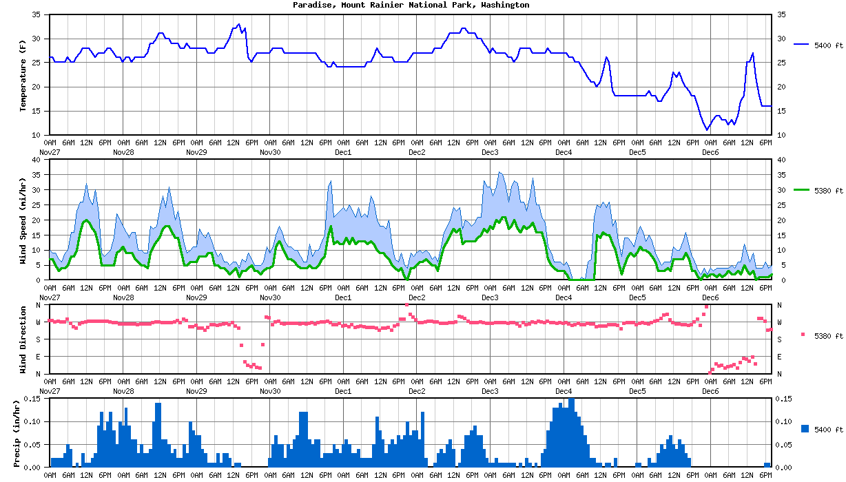
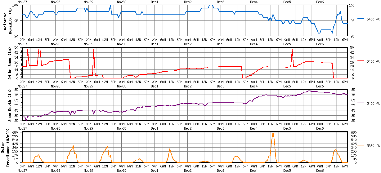
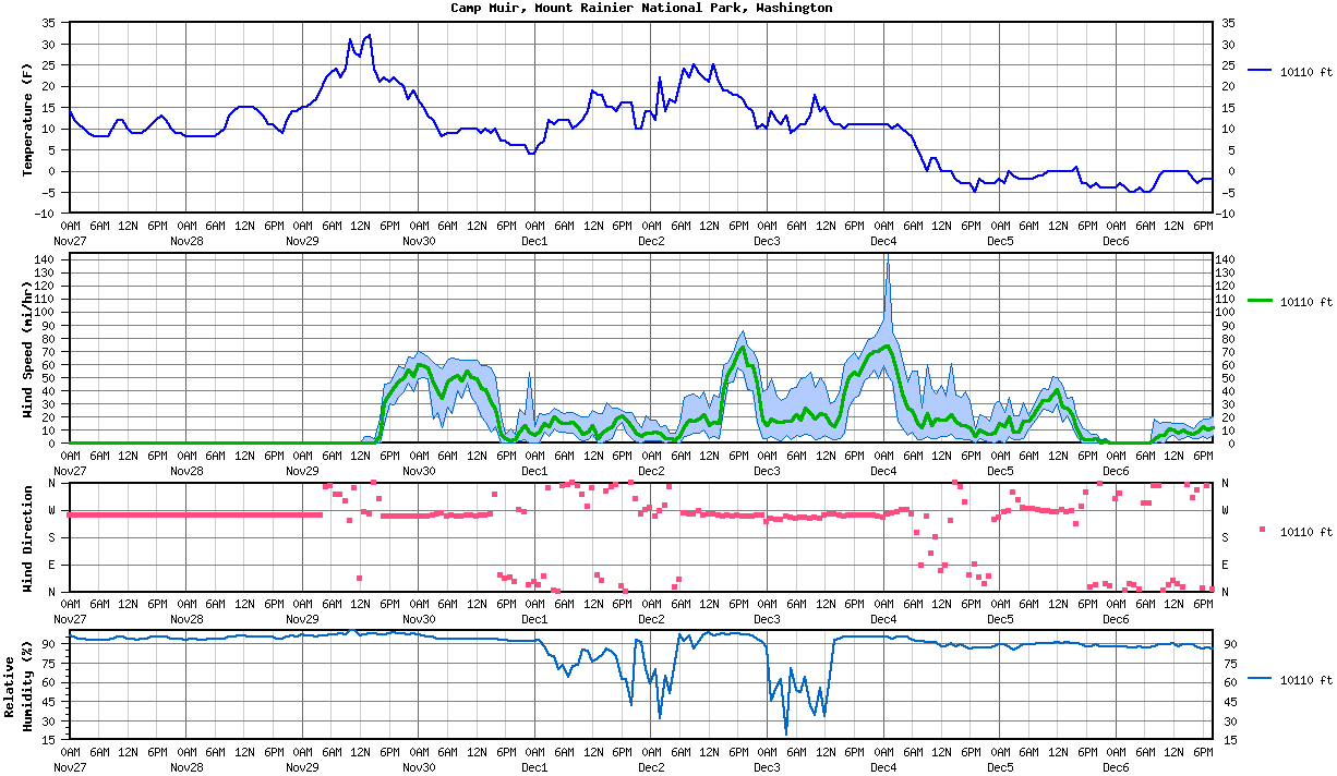
Plots of NWAC telemetry data from Paradise and Camp Muir over the previous 8 days and into the next day. Note in particular the rapid increase in snowdepth starting November 23, as about 4-5 ft of new snow fell from that day through the morning of November 29 (unfortunately the 24-hour snowdepth board was not cleared off for 4 days in the middle of that, so the new snow amount was under-recorded due to settlement). Also note the sudden change in conditions at Camp Muir shortly after I skied down, with winds rapidly increasing to 40 mph and then 60+ mph, along with a sharp drop in temperature by the next morning, and almost a foot of new snow at Paradise by the next afternoon. Hope those 2 snowshoers did OK in all that!!
[img width=1000 height=570">http://www.skimountaineer.com/TR/Images2016/osopvc1-29Nov2016.png" />
[img width=1000 height=454">http://www.skimountaineer.com/TR/Images2016/osopvc2-29Nov2016.png" />
[img width=1000 height=580">http://www.skimountaineer.com/TR/Images2016/osomur-29Nov2016.png" />
And the actual telemetry data for the last 3+ days of those plots. The wind speed at Muir was rimed and frozen for many days prior to melting free after noon on November 29:
Northwest Avalanche Center Northwest Avalanche Center
Paradise, Mt Rainier National Park, Washington Camp Muir, Mt Rainier National Park, Washington
Wind gages unheated and may rime
MM/DD Hour Temp RH Wind Wind Wind Hour Total 24 Hr Total Solar MM/DD Hour Temp RH Wind Wind Wind Wind Solar
PST F % Avg Max Dir Prec Prec Snow Snow W/m2 PST F % Min Avg Max Dir w/m2
5400' 5400' 5380' 5380' 5380' 5400' 5400' 5400' 5400' 5380' 10110' 10110' 10110' 10110' 10110' 10110' 10110'
------------------------------------------------------------------------ ---------------------------------------------------------------
11 30 1400 27 97 4 8 263 .05 .71 6 51 67 11 30 1400 10 94 16 41 59 249 139
11 30 1300 27 97 5 12 262 .06 .66 5 50 87 11 30 1300 9 94 20 42 59 249 170
11 30 1200 27 97 4 6 258 .12 .6 4 51 60 11 30 1200 10 94 29 49 63 247 144
11 30 1100 27 97 4 6 260 .12 .48 2 48 61 11 30 1100 10 94 35 50 63 249 147
11 30 1000 27 98 4 8 258 .12 .36 0 44 48 11 30 1000 10 94 46 55 63 251 114
11 30 900 27 98 5 10 261 .07 .24 5 46 20 11 30 900 10 94 34 48 63 248 46
11 30 800 27 98 6 10 260 .06 .17 4 46 3 11 30 800 9 94 40 52 64 248 17
11 30 700 27 98 7 11 260 .04 .11 4 46 0 11 30 700 9 94 23 49 65 249 0
11 30 600 27 98 7 11 260 .05 .07 4 45 0 11 30 600 9 94 28 47 63 248 0
11 30 500 27 98 9 13 257 .02 .02 4 45 0 11 30 500 8 94 12 34 57 256 0
------------------------------------------------------------------------ ---------------------------------------------------------------
11 30 400 28 98 11 16 262 .05 .4 3 45 0 11 30 400 10 94 24 39 59 255 0
11 30 300 28 98 13 18 270 .05 .35 2 42 0 11 30 300 12 95 19 46 62 250 0
11 30 200 28 98 11 15 267 .07 .3 2 43 0 11 30 200 13 95 49 58 66 247 0
11 30 100 28 98 5 11 252 .05 .23 0 41 0 11 30 100 15 96 50 59 68 246 0
11 30 0 27 98 4 9 290 .02 .18 0 42 0 11 30 0 17 97 49 60 70 247 0
11 29 2300 27 97 4 11 293 0 .16 0 41 0 11 29 2300 19 98 39 51 65 248 0
11 29 2200 27 96 3 6 151 0 .16 0 42 0 11 29 2200 17 97 46 56 66 247 0
11 29 2100 27 97 2 5 26 0 .16 0 42 0 11 29 2100 20 98 39 50 57 247 0
11 29 2000 27 97 3 5 31 0 .16 0 43 0 11 29 2000 21 98 35 47 59 247 0
11 29 1900 26 97 3 5 44 0 .16 0 42 0 11 29 1900 22 99 29 43 52 248 0
11 29 1800 25 97 5 7 35 0 .16 0 42 0 11 29 1800 21 98 30 38 46 248 0
11 29 1700 26 97 4 9 43 0 .16 0 41 8 11 29 1700 22 97 15 31 45 247 12
11 29 1600 32 100 3 6 61 0 .16 0 41 155 11 29 1600 21 97 0 5 19 303 159
11 29 1500 31 98 3 7 147 0 .16 0 41 140 11 29 1500 24 98 0 0 4 357 171
11 29 1400 33 98 1 4 234 .01 .16 0 41 362 11 29 1400 32 98 0 0 5 255 418
11 29 1300 32 98 4 6 246 .01 .15 0 43 314 11 29 1300 31 97 0 0 5 262 460
11 29 1200 32 98 3 6 266 0 .14 0 43 258 11 29 1200 27 96 0 0 0 41 416
11 29 1100 30 98 2 5 254 .02 .14 0 44 211 11 29 1100 28 100 0 0 0 340 306
11 29 1000 29 98 3 6 262 .03 .12 5 44 153 11 29 1000 31 100 0 0 0 231 137
11 29 900 28 98 4 6 259 .03 .09 5 42 57 11 29 900 24 97 0 0 0 296 129
11 29 800 28 98 4 9 254 .01 .06 5 45 8 11 29 800 22 98 0 0 0 320 21
11 29 700 28 98 5 8 250 .03 .05 5 45 0 11 29 700 24 97 0 0 0 320 0
11 29 600 27 98 5 10 254 .01 .02 4 45 0 11 29 600 23 97 0 0 0 347 0
11 29 500 27 98 9 13 255 .01 .01 4 45 0 11 29 500 22 96 0 0 0 343 0
------------------------------------------------------------------------ ---------------------------------------------------------------
11 29 400 27 98 9 16 240 .01 1.32 47 37 0 11 29 400 19 96 0 0 0 251 0
11 29 300 28 98 8 14 226 .03 1.31 4 45 0 11 29 300 17 95 0 0 0 251 0
11 29 200 28 98 8 15 235 .04 1.28 4 45 0 11 29 200 16 96 0 0 0 251 0
11 29 100 28 98 8 17 236 .07 1.24 4 45 0 11 29 100 15 96 0 0 0 251 0
11 29 0 28 98 6 11 251 .07 1.17 4 45 0 11 29 0 15 97 0 0 0 251 0
11 28 2300 28 99 6 11 244 .08 1.1 3 45 0 11 28 2300 14 95 0 0 0 251 0
11 28 2200 28 98 6 10 242 .1 1.02 3 45 0 11 28 2200 14 96 0 0 0 251 0
11 28 2100 29 99 5 9 275 .03 .92 3 45 0 11 28 2100 12 95 0 0 0 251 0
11 28 2000 28 99 5 12 282 .05 .89 3 45 0 11 28 2000 9 94 0 0 0 251 0
11 28 1900 28 99 10 18 266 .02 .84 2 44 0 11 28 1900 10 94 0 0 0 251 0
11 28 1800 29 99 14 23 275 .02 .82 2 45 0 11 28 1800 11 95 0 0 0 251 0
11 28 1700 29 99 14 20 268 .04 .8 2 44 2 11 28 1700 11 95 0 0 0 251 2
11 28 1600 29 99 16 26 263 .03 .76 2 44 36 11 28 1600 13 95 0 0 0 251 17
11 28 1500 30 98 18 31 265 .05 .73 2 43 196 11 28 1500 14 95 0 0 0 251 72
11 28 1400 30 98 18 24 264 .06 .68 0 38 201 11 28 1400 15 95 0 0 0 251 85
11 28 1300 31 98 17 28 265 .06 .62 0 42 380 11 28 1300 15 95 0 0 0 251 105
11 28 1200 31 98 14 23 267 .14 .56 0 42 287 11 28 1200 15 96 0 0 0 251 124
11 28 1100 30 98 13 18 269 .14 .42 0 36 271 11 28 1100 15 96 0 0 0 251 141
11 28 1000 29 98 11 17 264 .1 .28 30 43 171 11 28 1000 14 95 0 0 0 251 90
11 28 900 29 98 9 18 258 .04 .18 30 42 144 11 28 900 13 95 0 0 0 251 164
11 28 800 27 98 4 9 259 .03 .14 30 43 7 11 28 800 10 94 0 0 0 251 61
11 28 700 26 98 5 9 258 .03 .11 30 43 0 11 28 700 9 94 0 0 0 251 0
11 28 600 26 98 5 10 256 .05 .08 30 43 0 11 28 600 8 94 0 0 0 251 0
11 28 500 26 98 6 10 255 .03 .03 29 42 0 11 28 500 8 94 0 0 0 251 0
------------------------------------------------------------------------ ---------------------------------------------------------------
11 28 400 26 98 7 16 257 .06 1.4 29 42 0 11 28 400 8 93 0 0 0 251 0
11 28 300 25 98 9 16 259 .06 1.34 29 43 0 11 28 300 8 93 0 0 0 251 0
11 28 200 26 98 9 14 259 .09 1.28 29 43 0 11 28 200 8 94 0 0 0 251 0
11 28 100 26 97 9 16 258 .13 1.19 29 42 0 11 28 100 8 94 0 0 0 251 0
11 28 0 25 97 11 18 259 .09 1.06 28 40 0 11 28 0 8 93 0 0 0 251 0
11 27 2300 26 98 10 20 257 .1 .97 28 41 0 11 27 2300 9 94 0 0 0 251 0
11 27 2200 26 98 9 22 265 .05 .87 27 42 0 11 27 2200 9 94 0 0 0 251 0
11 27 2100 27 98 5 14 266 .08 .82 27 42 0 11 27 2100 10 94 0 0 0 251 0
11 27 2000 28 98 5 10 267 .12 .74 27 40 0 11 27 2000 12 95 0 0 0 251 0
11 27 1900 28 98 5 9 271 .1 .62 25 37 0 11 27 1900 13 95 0 0 0 251 0
11 27 1800 27 98 5 8 270 .08 .52 23 36 0 11 27 1800 12 95 0 0 0 251 0
11 27 1700 27 98 5 9 271 .12 .44 22 37 0 11 27 1700 11 95 0 0 0 251 1
11 27 1600 27 98 11 22 271 .09 .32 23 36 6 11 27 1600 10 94 0 0 0 251 17
11 27 1500 26 97 16 30 271 .03 .23 21 35 21 11 27 1500 9 94 0 0 0 251 44
11 27 1400 27 97 17 25 271 .02 .2 21 34 52 11 27 1400 9 93 0 0 0 251 82
11 27 1300 28 97 19 27 273 .01 .18 47 32 102 11 27 1300 9 94 0 0 0 251 126
11 27 1200 28 97 20 32 269 .01 .17 47 32 174 11 27 1200 10 94 0 0 0 251 233
11 27 1100 28 96 19 26 266 .03 .16 21 34 143 11 27 1100 12 95 0 0 0 251 189
11 27 1000 27 96 16 26 258 0 .13 21 34 139 11 27 1000 12 95 0 0 0 251 65
Not bad looking turns, even on the worst part of the snow, looking up from 9200 ft.
Ski conditions were back to outstanding the rest of the way below 9200 ft, so smooth and fast, carving GS turns in the glow of sunset.
A minute later I was again surprised to see a pair of snowshoers ascending up my skintrack near 8500 ft, with heavy overnight packs and largely destroying the skintrack as usual. I asked them if they were running a GPS track, since a storm was coming in overnight which would bury the skintrack completely, they would be descending in whiteout conditions the next day, and I had intentionally placed the skintrack far away from the "handrail", the rocks along the east edge of the Muir Snowfield which are commonly used by parties on foot to navigate in whiteout. I also mentioned, although it didn't matter this time since the track would be buried shortly anyway, in general it was good etiquette to not destroy skintracks and instead make a separate foot track to the side. They thanked me for my advice.
[img width=1000 height=233">http://www.skimountaineer.com/TR/Images2016/RainierMuirSunsetPano3000-29Nov2016.jpg" />
Sunset panorama spanning about 260° near 7300 ft along the winter route. (click for triple-size version)
Even along the traverse of the winter route, ski conditions remained outstanding, and the numerous rock outcrops were well plastered with enough hard-frozen base to make ski damage unlikely. Could have also skied via Pebble Creek, which would have had equally good snow (or better) and far less rock outcrops.
4:15pm: Almost sunset from 7200 ft along the winter route.
The one area where the sun had affected the snow was on Pan Face, which had a bit of suncrust on the most sun-exposed SW aspect in the middle. A lone telemarker was still traversing slowly down that crusty part. But that was easy to avoid by hugging the skier's left edge, which faces more directly west and therefore gets little sun until almost sunset this time of year. Still lovely smooth powder on that side.
[img width=1000 height=233">http://www.skimountaineer.com/TR/Images2016/RainierPanFaceSunsetPano3000-29Nov2016.jpg" />
4:25pm: Sunset panorama of Rainier and Pan Face, with my tracks at farthest looker's right on the steep part of the face. (click for triple-size version)
Back to Paradise at 4:30pm, where the wet parts of the parking lot had rapidly refrozen into a hazardous sheet of ice. I realized that the upper parts of the road were likely to have similar ice and had no wish to rush down it to try to make the 5pm gate closing. Luckily, the LE ranger on duty was super friendly, and he even recognized me from this February, when he had very kindly given me and a friend a ride back up from Nisqually Bridge after we skied down to it from Muir. We had a nice chat about the park's winter nordic patrol as I changed over in the twilight, and I told him about the 2 skiers still not yet down, as well as the snowshoers headed up. He said there was no need for me to rush, as he had to call in the remaining vehicles in the lot to park dispatch anyway before heading down to lock the gate. So that worked out perfect!
Just another outstanding, inspiring day on the great Mountain, with stellar views, solar halos, and stunning ski conditions!
MOUNT RAINIER RECREATIONAL FORECAST
NATIONAL WEATHER SERVICE SEATTLE WA
520 AM PST TUE NOV 29 2016
SYNOPSIS...HIGH ALOFT WILL PREVAIL DURING THE DAY TODAY FOR MOSTLY DRY CONDITIONS. A WEAK LOW PRESSURE SYSTEM WILL BRING RAIN AND MOUNTAIN SNOW TO THE AREA STARTING TONIGHT AND CONTINUING INTO WEDNESDAY. THE REMNANTS OF A WARM FRONT MAY BRING A SLIGHT CHANCE FOR SHOWERS ON AN OTHERWISE DRY THURSDAY.
IMPACTS...STORMY WEATHER TONIGHT AND WEDNESDAY WILL CREATE DIFFICULT MOUNTAINEERING CONDITIONS NEAR THE SUMMIT WITH LOCAL BLIZZARD- LIKE CONDITIONS...STRONG WINDS...AND NEAR ZERO VISIBILITY. A HIGH LEVEL OF SKILL AND EXPERIENCE IN ALPINE TERRAIN, INCLUDING USE OF GPS...IS RECOMMENDED FOR NAVIGATION AND CAMPING IN THESE CONDITIONS.
TUESDAY...MOSTLY CLOUDY. FREEZING LEVEL NEAR 4500 FEET.
TUESDAY NIGHT...MOSTLY CLOUDY WITH A CHANCE OF RAIN AND SNOW IN THE EVENING...THEN RAIN AND SNOW AFTER MIDNIGHT. SNOW ACCUMULATION NEAR PARADISE OF 2 TO 4 INCHES. SNOW LEVEL NEAR 4000 FEET.
WEDNESDAY...SHOWERS. SNOW ACCUMULATION NEAR PARADISE OF 2 TO 3 INCHES. SNOW LEVEL NEAR 2500 FEET.
WEDNESDAY NIGHT...SHOWERS LIKELY. LIGHT SNOW ACCUMULATIONS. SNOW LEVEL NEAR 2500 FEET.
THURSDAY...MOSTLY CLOUDY. A SLIGHT CHANCE OF SHOWERS IN THE MORNING...THEN A CHANCE OF SHOWERS IN THE AFTERNOON. SNOW LEVEL NEAR 2000 FEET.
TEMPERATURE AND WIND FORECASTS FOR SELECTED LOCATIONS.
TUE TUE WED WED THU
NIGHT NIGHT
SUMMIT (14411 FT) 11 5 -9 -3 -2
NW 25 SW 40 W 35 NW 45 NW 35
CAMP MUIR(10188 FT) 23 20 8 8 9
NW 15 SW 30 W 30 NW 25 NW 30
PARADISE (5420 FT) 31 25 29 24 30
W 10 S 10 W 15 W 10 W 10
LONGMIRE (2760 FT) 37 33 36 33 36
S 5 E 5 W 10 W 10 W 10
++ TEMPERATURES AND WIND FOR THE SUMMIT AND CAMP MUIR ARE AVERAGE
CONDITIONS EXPECTED IN THE FREE AIR AT THOSE ELEVATIONS.
++ TEMPERATURES FOR PARADISE AND LONGMIRE ARE THE EXPECTED HIGHS AND
LOWS. WIND IS THE AVERAGE WIND EXPECTED DURING THAT PERIOD.
EXTENDED FORECAST...
THURSDAY NIGHT...MOSTLY CLOUDY WITH A SLIGHT CHANCE OF RAIN AND SNOW. SNOW LEVEL NEAR 2500 FEET.
FRIDAY...RAIN AND SNOW LIKELY. SNOW LEVEL NEAR 3500 FEET.
FRIDAY NIGHT...RAIN AND SNOW. SNOW LEVEL NEAR 4500 FEET.
SATURDAY...RAIN AND SNOW LIKELY. SNOW LEVEL NEAR 3500 FEET.
SATURDAY NIGHT...RAIN AND SNOW. SNOW LEVEL NEAR 3000 FEET.
SUNDAY...RAIN AND SNOW. SNOW LEVEL NEAR 2000 FEET.
SUNDAY NIGHT...SHOWERS LIKELY. SNOW LEVEL NEAR 500 FEET.
MONDAY...CLOUDY WITH A CHANCE OF SNOW SHOWERS.
Plots of NWAC telemetry data from Paradise and Camp Muir over the previous 8 days and into the next day. Note in particular the rapid increase in snowdepth starting November 23, as about 4-5 ft of new snow fell from that day through the morning of November 29 (unfortunately the 24-hour snowdepth board was not cleared off for 4 days in the middle of that, so the new snow amount was under-recorded due to settlement). Also note the sudden change in conditions at Camp Muir shortly after I skied down, with winds rapidly increasing to 40 mph and then 60+ mph, along with a sharp drop in temperature by the next morning, and almost a foot of new snow at Paradise by the next afternoon. Hope those 2 snowshoers did OK in all that!!
[img width=1000 height=570">http://www.skimountaineer.com/TR/Images2016/osopvc1-29Nov2016.png" />
[img width=1000 height=454">http://www.skimountaineer.com/TR/Images2016/osopvc2-29Nov2016.png" />
[img width=1000 height=580">http://www.skimountaineer.com/TR/Images2016/osomur-29Nov2016.png" />
And the actual telemetry data for the last 3+ days of those plots. The wind speed at Muir was rimed and frozen for many days prior to melting free after noon on November 29:
Northwest Avalanche Center Northwest Avalanche Center
Paradise, Mt Rainier National Park, Washington Camp Muir, Mt Rainier National Park, Washington
Wind gages unheated and may rime
MM/DD Hour Temp RH Wind Wind Wind Hour Total 24 Hr Total Solar MM/DD Hour Temp RH Wind Wind Wind Wind Solar
PST F % Avg Max Dir Prec Prec Snow Snow W/m2 PST F % Min Avg Max Dir w/m2
5400' 5400' 5380' 5380' 5380' 5400' 5400' 5400' 5400' 5380' 10110' 10110' 10110' 10110' 10110' 10110' 10110'
------------------------------------------------------------------------ ---------------------------------------------------------------
11 30 1400 27 97 4 8 263 .05 .71 6 51 67 11 30 1400 10 94 16 41 59 249 139
11 30 1300 27 97 5 12 262 .06 .66 5 50 87 11 30 1300 9 94 20 42 59 249 170
11 30 1200 27 97 4 6 258 .12 .6 4 51 60 11 30 1200 10 94 29 49 63 247 144
11 30 1100 27 97 4 6 260 .12 .48 2 48 61 11 30 1100 10 94 35 50 63 249 147
11 30 1000 27 98 4 8 258 .12 .36 0 44 48 11 30 1000 10 94 46 55 63 251 114
11 30 900 27 98 5 10 261 .07 .24 5 46 20 11 30 900 10 94 34 48 63 248 46
11 30 800 27 98 6 10 260 .06 .17 4 46 3 11 30 800 9 94 40 52 64 248 17
11 30 700 27 98 7 11 260 .04 .11 4 46 0 11 30 700 9 94 23 49 65 249 0
11 30 600 27 98 7 11 260 .05 .07 4 45 0 11 30 600 9 94 28 47 63 248 0
11 30 500 27 98 9 13 257 .02 .02 4 45 0 11 30 500 8 94 12 34 57 256 0
------------------------------------------------------------------------ ---------------------------------------------------------------
11 30 400 28 98 11 16 262 .05 .4 3 45 0 11 30 400 10 94 24 39 59 255 0
11 30 300 28 98 13 18 270 .05 .35 2 42 0 11 30 300 12 95 19 46 62 250 0
11 30 200 28 98 11 15 267 .07 .3 2 43 0 11 30 200 13 95 49 58 66 247 0
11 30 100 28 98 5 11 252 .05 .23 0 41 0 11 30 100 15 96 50 59 68 246 0
11 30 0 27 98 4 9 290 .02 .18 0 42 0 11 30 0 17 97 49 60 70 247 0
11 29 2300 27 97 4 11 293 0 .16 0 41 0 11 29 2300 19 98 39 51 65 248 0
11 29 2200 27 96 3 6 151 0 .16 0 42 0 11 29 2200 17 97 46 56 66 247 0
11 29 2100 27 97 2 5 26 0 .16 0 42 0 11 29 2100 20 98 39 50 57 247 0
11 29 2000 27 97 3 5 31 0 .16 0 43 0 11 29 2000 21 98 35 47 59 247 0
11 29 1900 26 97 3 5 44 0 .16 0 42 0 11 29 1900 22 99 29 43 52 248 0
11 29 1800 25 97 5 7 35 0 .16 0 42 0 11 29 1800 21 98 30 38 46 248 0
11 29 1700 26 97 4 9 43 0 .16 0 41 8 11 29 1700 22 97 15 31 45 247 12
11 29 1600 32 100 3 6 61 0 .16 0 41 155 11 29 1600 21 97 0 5 19 303 159
11 29 1500 31 98 3 7 147 0 .16 0 41 140 11 29 1500 24 98 0 0 4 357 171
11 29 1400 33 98 1 4 234 .01 .16 0 41 362 11 29 1400 32 98 0 0 5 255 418
11 29 1300 32 98 4 6 246 .01 .15 0 43 314 11 29 1300 31 97 0 0 5 262 460
11 29 1200 32 98 3 6 266 0 .14 0 43 258 11 29 1200 27 96 0 0 0 41 416
11 29 1100 30 98 2 5 254 .02 .14 0 44 211 11 29 1100 28 100 0 0 0 340 306
11 29 1000 29 98 3 6 262 .03 .12 5 44 153 11 29 1000 31 100 0 0 0 231 137
11 29 900 28 98 4 6 259 .03 .09 5 42 57 11 29 900 24 97 0 0 0 296 129
11 29 800 28 98 4 9 254 .01 .06 5 45 8 11 29 800 22 98 0 0 0 320 21
11 29 700 28 98 5 8 250 .03 .05 5 45 0 11 29 700 24 97 0 0 0 320 0
11 29 600 27 98 5 10 254 .01 .02 4 45 0 11 29 600 23 97 0 0 0 347 0
11 29 500 27 98 9 13 255 .01 .01 4 45 0 11 29 500 22 96 0 0 0 343 0
------------------------------------------------------------------------ ---------------------------------------------------------------
11 29 400 27 98 9 16 240 .01 1.32 47 37 0 11 29 400 19 96 0 0 0 251 0
11 29 300 28 98 8 14 226 .03 1.31 4 45 0 11 29 300 17 95 0 0 0 251 0
11 29 200 28 98 8 15 235 .04 1.28 4 45 0 11 29 200 16 96 0 0 0 251 0
11 29 100 28 98 8 17 236 .07 1.24 4 45 0 11 29 100 15 96 0 0 0 251 0
11 29 0 28 98 6 11 251 .07 1.17 4 45 0 11 29 0 15 97 0 0 0 251 0
11 28 2300 28 99 6 11 244 .08 1.1 3 45 0 11 28 2300 14 95 0 0 0 251 0
11 28 2200 28 98 6 10 242 .1 1.02 3 45 0 11 28 2200 14 96 0 0 0 251 0
11 28 2100 29 99 5 9 275 .03 .92 3 45 0 11 28 2100 12 95 0 0 0 251 0
11 28 2000 28 99 5 12 282 .05 .89 3 45 0 11 28 2000 9 94 0 0 0 251 0
11 28 1900 28 99 10 18 266 .02 .84 2 44 0 11 28 1900 10 94 0 0 0 251 0
11 28 1800 29 99 14 23 275 .02 .82 2 45 0 11 28 1800 11 95 0 0 0 251 0
11 28 1700 29 99 14 20 268 .04 .8 2 44 2 11 28 1700 11 95 0 0 0 251 2
11 28 1600 29 99 16 26 263 .03 .76 2 44 36 11 28 1600 13 95 0 0 0 251 17
11 28 1500 30 98 18 31 265 .05 .73 2 43 196 11 28 1500 14 95 0 0 0 251 72
11 28 1400 30 98 18 24 264 .06 .68 0 38 201 11 28 1400 15 95 0 0 0 251 85
11 28 1300 31 98 17 28 265 .06 .62 0 42 380 11 28 1300 15 95 0 0 0 251 105
11 28 1200 31 98 14 23 267 .14 .56 0 42 287 11 28 1200 15 96 0 0 0 251 124
11 28 1100 30 98 13 18 269 .14 .42 0 36 271 11 28 1100 15 96 0 0 0 251 141
11 28 1000 29 98 11 17 264 .1 .28 30 43 171 11 28 1000 14 95 0 0 0 251 90
11 28 900 29 98 9 18 258 .04 .18 30 42 144 11 28 900 13 95 0 0 0 251 164
11 28 800 27 98 4 9 259 .03 .14 30 43 7 11 28 800 10 94 0 0 0 251 61
11 28 700 26 98 5 9 258 .03 .11 30 43 0 11 28 700 9 94 0 0 0 251 0
11 28 600 26 98 5 10 256 .05 .08 30 43 0 11 28 600 8 94 0 0 0 251 0
11 28 500 26 98 6 10 255 .03 .03 29 42 0 11 28 500 8 94 0 0 0 251 0
------------------------------------------------------------------------ ---------------------------------------------------------------
11 28 400 26 98 7 16 257 .06 1.4 29 42 0 11 28 400 8 93 0 0 0 251 0
11 28 300 25 98 9 16 259 .06 1.34 29 43 0 11 28 300 8 93 0 0 0 251 0
11 28 200 26 98 9 14 259 .09 1.28 29 43 0 11 28 200 8 94 0 0 0 251 0
11 28 100 26 97 9 16 258 .13 1.19 29 42 0 11 28 100 8 94 0 0 0 251 0
11 28 0 25 97 11 18 259 .09 1.06 28 40 0 11 28 0 8 93 0 0 0 251 0
11 27 2300 26 98 10 20 257 .1 .97 28 41 0 11 27 2300 9 94 0 0 0 251 0
11 27 2200 26 98 9 22 265 .05 .87 27 42 0 11 27 2200 9 94 0 0 0 251 0
11 27 2100 27 98 5 14 266 .08 .82 27 42 0 11 27 2100 10 94 0 0 0 251 0
11 27 2000 28 98 5 10 267 .12 .74 27 40 0 11 27 2000 12 95 0 0 0 251 0
11 27 1900 28 98 5 9 271 .1 .62 25 37 0 11 27 1900 13 95 0 0 0 251 0
11 27 1800 27 98 5 8 270 .08 .52 23 36 0 11 27 1800 12 95 0 0 0 251 0
11 27 1700 27 98 5 9 271 .12 .44 22 37 0 11 27 1700 11 95 0 0 0 251 1
11 27 1600 27 98 11 22 271 .09 .32 23 36 6 11 27 1600 10 94 0 0 0 251 17
11 27 1500 26 97 16 30 271 .03 .23 21 35 21 11 27 1500 9 94 0 0 0 251 44
11 27 1400 27 97 17 25 271 .02 .2 21 34 52 11 27 1400 9 93 0 0 0 251 82
11 27 1300 28 97 19 27 273 .01 .18 47 32 102 11 27 1300 9 94 0 0 0 251 126
11 27 1200 28 97 20 32 269 .01 .17 47 32 174 11 27 1200 10 94 0 0 0 251 233
11 27 1100 28 96 19 26 266 .03 .16 21 34 143 11 27 1100 12 95 0 0 0 251 189
11 27 1000 27 96 16 26 258 0 .13 21 34 139 11 27 1000 12 95 0 0 0 251 65
Welcome back. ;)
Well, I really am rusty on this whole TR-writing thing -- accidentally posted this in December! I've asked the moderators to move it.
Looks beautiful, Amar. Glad to hear you got no grief from the LE's, too.
Glad to see an Amar TR!
Alpine!
Thanks for the amazing TR/Pic's from the epic day.
I was one of the skiers you passed on the up and turned at 9000'.
Definitely felt like I got a high five from the Universe.
I was one of the skiers you passed on the up and turned at 9000'.
Definitely felt like I got a high five from the Universe.
Nice seeing you in the parking lot, Amar. We followed you up a ways, but still conditioning the old legs and joints:

author=Amar Andalkar link=topic=37188.msg150892#msg150892 date=1480736100]
A minute later I was again surprised to see a pair of snowshoers ascending up my skintrack near 8500 ft, with heavy overnight packs and largely destroying the skintrack as usual. I asked them if they were running a GPS track, since a storm was coming in overnight which would bury the skintrack completely, they would be descending in whiteout conditions the next day, and I had intentionally placed the skintrack far away from the "handrail", the rocks along the east edge of the Muir Snowfield which are commonly used by parties on foot to navigate in whiteout. I also mentioned, although it didn't matter this time since the track would be buried shortly anyway, in general it was good etiquette to not destroy skintracks and instead make a separate foot track to the side. They thanked me for my advice.
.
.
.
... Also note the sudden change in conditions at Camp Muir shortly after I skied down, with winds rapidly increasing to 40 mph and then 60+ mph, along with a sharp drop in temperature by the next morning, and almost a foot of new snow at Paradise by the next afternoon. Hope those 2 snowshoers did OK in all that!!
Well, it turns out the snowshoers did NOT do OK in the stormy whiteout conditions! Found out from the climbing rangers today in the Paradise parking lot that there was a rescue last Wednesday, and I knew instantly it had to be those snowshoers. It was. Apparently they had no goggles or eye protection with them, so were unable to descend from Muir in the wind-driven snow and whiteout on Wednesday, and called for help. Although I'm glad I checked on them to make sure they were running a GPS track, that's of little use if you can't open your eyes enough to see the GPS and walk down. Climbing rangers went up to the Muir hut that afternoon with goggles for them, and they all descended safely. Lucky guys!
About 30" of new light powder at Paradise today (Dec 6) atop the previous base. That low-density snow fell from Saturday night through Monday afternoon (Dec 3-5), on top of the 25"+ of much denser snow which fell after my trip to Muir from Nov 30 to Dec 2. Skied great with minimal wind affect under partly sunny skies, although pole penetration was often 24-30" (deeper in spots) and ski penetration generally 12"+, so trail breaking was serious work. Far too cold to even consider going up into the alpine regions, with temps below 0 °F at Muir, so just powder laps up to treeline. Snowing again at times by late afternoon.
Reply to this TR
Please login first: