May 9, 2015, Mt Adams South Route/Crescent Glacier
5/9/15
WA Cascades West Slopes South (Mt Rainier)
2259
0
After summiting Adams last June (2014) for the first time, and having one of the greatest runs of my life on the Southwest Chutes, I decided another trip was in order. Since it's basically June right now I figured this would be the right time of year for a repeat. I had wanted to go in March but had inconclusive information about the status of the road, and ended up doing Hood for the first time instead, only to find out the road had opened that weekend...in hindsight I'm glad we didn't find out until after doing Hood.
Interestingly, I overheard some guys say that the snow pack is 8 weeks ahead of schedule on and around Adams. I'd say the levels may be two months ahead but I would imagine that the July snow on Adams would be more deeply runneled and suncupped, so snow quality is probably more like a month ahead, as opposed to two...
Anyways, due to obligations Saturday evening, and the fact that I convinced my girlfriend to hike at least to the lunch counter, I decided to make Piker's my high point. Also, the south route had looked like a pretty appealing descent last year so I decided I would give that a try, down to the Crescent, and save myself the additional hour and a half or so it took us last year to traverse back around and find a suitable place to drop in and reconnect to the climbing route.
We camped at the last bend in the road before the section where most cars park and positioned the car to block the tent from most of the road dust stirred up by cars coming in after us. Unlike Timberline, where we rolled in around 1AM to start our climb and were able to park away from any potential parking lot sleepers without disturbing them, each car that drove by, the last one I was aware of was about 2:30, woke me up. I can't actually fault anyone for the early morning strategy, I just blame myself for not backpacking up the trail a mile or so past the burn, or bringing earplugs. Just goes with the territory.
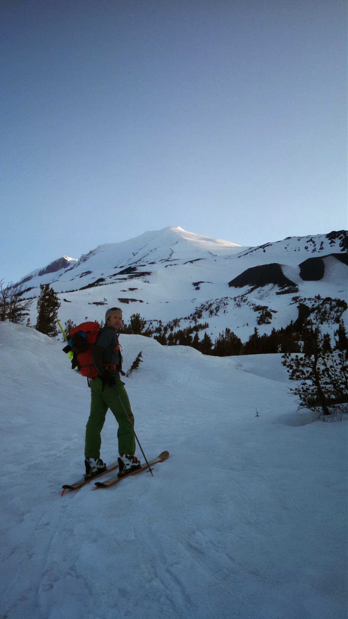
We woke at 4AM and in no particular rush hit the trail approximately 5:15 after several trips back to the car from up the road. I can't leave anywhere without forgetting at least a few things.
We stayed lower and lefter longer than we probably should have and ended up in the big canyon/gulley that the crescent empties into, passing another couple who was unsure of exactly how to get back onto the climbing route. I told them we'd likely have to boot back up somewhere to gain the trail near what I think is South Butte? As I figured I skinned up a ways and then took my skis off and booted up through some small trees and boulders back to the trail. It was a little more effort but fun route finding.
Once back on route we steadily made our way to the lunch counter and were sitting with boots off in the warm sun eating a snack by about 8:45. At 9 I left my girlfriend to hang and explore the lunch counter and headed up the steep slope towards Piker's. I was determined to skin to the top, despite not having ski crampons, but gave up about 200 feet below the false summit as I was slipping, sweating, exhausted, and perhaps a little more scared than I care to admit about one of those super awkward kickturn slides. I sat down, put on my crampons, had some water, and was up top huffing and puffing in no time. Hard to think crampons wouldn't be more efficient for most of that stretch but I think it's a pride thing.
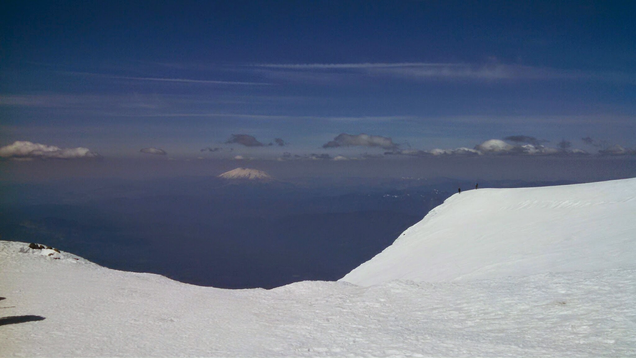
I rested and enjoyed the stellar, though slightly hazy, views from the false summit, ate a burrito my gf had made me, and then heeded the advice of a recently arrived gentlemen who felt the climbing route was just about prime (about 11:30AM). Then off I went. First couple turns were a hair glassy but then the skiing was great. It wasn't the silky smooth corn turns from last year in the chutes but it was great, soft, carvable snow all the way back to the lunch counter. There were a few spots of leftover iciness, and a couple heavier snow spots, but all in all a whoooop worthy descent. Though I hadn't descended the Crescent before, I felt confident in picking my way through if need be. I knew it was early enough to not be too concerned about anything wet sliding, other than maybe a boulder. There wasn't another soul on that part of the mountain and I cut wide-arcing, low-angle turns while smiling widely. I easily caught back up with the climbing trail and made heavy snow turns, connecting patches with a few dirt steps probably an eighth to quarter of a mile past where I had put my skins on. The trail through the burn section is pretty brutal after a long day with the large amount of golf ball plus sized rocks all over the path.
On the way to the car I stopped and put out a deserted fire that clearly had started back up in the dry, warm, wind. A flame had kicked up on one of the logs and I poured the rest of my water from my camel back onto the log and then spent 10 minutes shoveling dirt over the logs with a stick. The fire wasn't all that far from other dry wood and grass and is in a burn zone...
Anyways, my gf had gotten a little lost coming down, I blame myself, but got back on track and back to the car after seeing what she surmises were mountain lion tracks, and more disconcerting, snowmobile tracks that crossed onto both sides of the Wilderness boundary (I know there was talk of this in an earlier thread). Not too cool. Anyways, awesome day and I dare say the South Face and Crescent glacier rivals the sw chutes as a great descent after factoring in the traverse.
Link to more pics: https://plus.google.com/photos/112962300745423553434/albums/6147752960926780817
Interestingly, I overheard some guys say that the snow pack is 8 weeks ahead of schedule on and around Adams. I'd say the levels may be two months ahead but I would imagine that the July snow on Adams would be more deeply runneled and suncupped, so snow quality is probably more like a month ahead, as opposed to two...
Anyways, due to obligations Saturday evening, and the fact that I convinced my girlfriend to hike at least to the lunch counter, I decided to make Piker's my high point. Also, the south route had looked like a pretty appealing descent last year so I decided I would give that a try, down to the Crescent, and save myself the additional hour and a half or so it took us last year to traverse back around and find a suitable place to drop in and reconnect to the climbing route.
We camped at the last bend in the road before the section where most cars park and positioned the car to block the tent from most of the road dust stirred up by cars coming in after us. Unlike Timberline, where we rolled in around 1AM to start our climb and were able to park away from any potential parking lot sleepers without disturbing them, each car that drove by, the last one I was aware of was about 2:30, woke me up. I can't actually fault anyone for the early morning strategy, I just blame myself for not backpacking up the trail a mile or so past the burn, or bringing earplugs. Just goes with the territory.
We woke at 4AM and in no particular rush hit the trail approximately 5:15 after several trips back to the car from up the road. I can't leave anywhere without forgetting at least a few things.
We stayed lower and lefter longer than we probably should have and ended up in the big canyon/gulley that the crescent empties into, passing another couple who was unsure of exactly how to get back onto the climbing route. I told them we'd likely have to boot back up somewhere to gain the trail near what I think is South Butte? As I figured I skinned up a ways and then took my skis off and booted up through some small trees and boulders back to the trail. It was a little more effort but fun route finding.
Once back on route we steadily made our way to the lunch counter and were sitting with boots off in the warm sun eating a snack by about 8:45. At 9 I left my girlfriend to hang and explore the lunch counter and headed up the steep slope towards Piker's. I was determined to skin to the top, despite not having ski crampons, but gave up about 200 feet below the false summit as I was slipping, sweating, exhausted, and perhaps a little more scared than I care to admit about one of those super awkward kickturn slides. I sat down, put on my crampons, had some water, and was up top huffing and puffing in no time. Hard to think crampons wouldn't be more efficient for most of that stretch but I think it's a pride thing.
I rested and enjoyed the stellar, though slightly hazy, views from the false summit, ate a burrito my gf had made me, and then heeded the advice of a recently arrived gentlemen who felt the climbing route was just about prime (about 11:30AM). Then off I went. First couple turns were a hair glassy but then the skiing was great. It wasn't the silky smooth corn turns from last year in the chutes but it was great, soft, carvable snow all the way back to the lunch counter. There were a few spots of leftover iciness, and a couple heavier snow spots, but all in all a whoooop worthy descent. Though I hadn't descended the Crescent before, I felt confident in picking my way through if need be. I knew it was early enough to not be too concerned about anything wet sliding, other than maybe a boulder. There wasn't another soul on that part of the mountain and I cut wide-arcing, low-angle turns while smiling widely. I easily caught back up with the climbing trail and made heavy snow turns, connecting patches with a few dirt steps probably an eighth to quarter of a mile past where I had put my skins on. The trail through the burn section is pretty brutal after a long day with the large amount of golf ball plus sized rocks all over the path.
On the way to the car I stopped and put out a deserted fire that clearly had started back up in the dry, warm, wind. A flame had kicked up on one of the logs and I poured the rest of my water from my camel back onto the log and then spent 10 minutes shoveling dirt over the logs with a stick. The fire wasn't all that far from other dry wood and grass and is in a burn zone...
Anyways, my gf had gotten a little lost coming down, I blame myself, but got back on track and back to the car after seeing what she surmises were mountain lion tracks, and more disconcerting, snowmobile tracks that crossed onto both sides of the Wilderness boundary (I know there was talk of this in an earlier thread). Not too cool. Anyways, awesome day and I dare say the South Face and Crescent glacier rivals the sw chutes as a great descent after factoring in the traverse.
Link to more pics: https://plus.google.com/photos/112962300745423553434/albums/6147752960926780817
Reply to this TR
Please login first: