- Posts: 635
- Thank you received: 0
Mt Shasta gets 3 ft new snow in 24 hrs!! 07Feb2015
- Amar Andalkar
-
 Topic Author
- User
-

Less
More
11 years 2 months ago - 11 years 2 months ago #223756
by Amar Andalkar
Mt Shasta gets 3 ft new snow in 24 hrs!! 07Feb2015 was created by Amar Andalkar
See also two similar snowfall & snowpack threads earlier this season:
Lassen Peak CA reaches 100" snowdepth!! 17Dec2014
Lyman Lake SNOTEL hits 100" snowdepth!?! 05Jan2015
[hr]I'm still actively looking for positive snowpack news amid all the gloom and rain and negativity so far during this highly unusual season in the Pacific Northwest and the entire West Coast. Despite a snowpack which remains well below-normal at almost all measurement sites, making it thus far the worst season since 2005 in the Northwest, it's really nowhere near the record lows of 2005 or 1977. And the ski conditions were actually good to excellent throughout most of January as long as one went to the right places on the numerous sunny days (awesome south-facing corn from 6000 to as high as 11000 ft on many of the volcanoes from Rainier all the way south to Shasta and Lassen, outstanding smooth fast empty groomers at Crystal, etc.), and avoided obvious pitfalls like non-south-facing slopes and cloudy days and places with clearly inadequate snowpack.
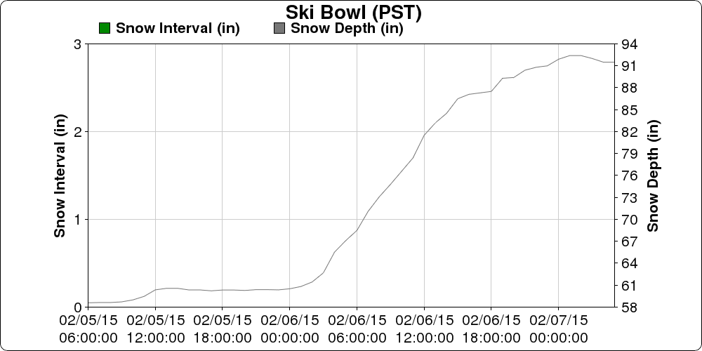
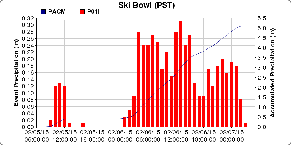
So here is some more good news in the midst of yet another series of strong, wet, and warm atmospheric rivers: Mount Shasta Old Ski Bowl at 7600 ft just received 3 ft of new snow in a 24-hour period ending around 1am on Saturday, February 7, with snowdepth increasing from 60" to 92" over that period and about 4.5" of precip falling. About 24" of new snow fell in 12 hours from 3am to 3pm Friday during the most intense phase of the storm:
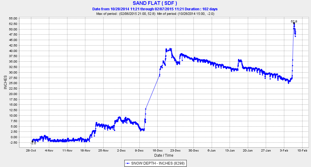
Lower down on Mount Shasta, the CCSS telemetry site at Sand Flat at 6750 ft also got over 2 ft of new snow in 24 hours, with snowdepth nearly doubling from 27" to 53", and there was 5" new down to the base of the Mount Shasta Ski Park at 5500 ft, which fell atop mostly bare ground at the closed ski area. Here is the snowdepth at Sand Flat over this season, unfortunately there was a data outage during the huge December snowstorm, but thankfully the site came back online afterwards:
A bit of new snow even fell down to about 4500 ft at Lassen and Shasta as colder air got pulled in around the low on Friday, while frustratingly the snow level still remained higher than that at 6000-7000 ft over much of the Washington Cascades and northern Oregon Cascades as much warmer air ended up farther north, very similar to what happened in the huge mid-December storm which dumped 4-5 ft in 36 hours on Lassen and Shasta. The region of heavy snowfall this time extended north through most of the southern Oregon Cascades as far north as Mount Bachelor, with 11-14" new reported in 24 hours at Mount Bachelor's 6300 and 7300 ft measurement sites, while Crater Lake got about 22" at the Crater Lake Rim telemetry site (7050 ft) and 18" at Crater Lake Park HQ (6400 ft) in 36 hours. There was also 19" new at Mount Ashland ski area (6500 ft) in the Siskiyous, allowing that community-owned non-profit ski area to reopen after a month-long closure due to lack of snow.
The current depth of over 90" at Mount Shasta Old Ski Bowl is just about 100% of normal for this date, although this telemetry site was only installed in December 2002, so the period of record is quite short. And it's astronomically better than last year, which had only 4" on the ground (!!) on 06Feb2014 prior to the huge February storm cycle . Yes, last year Shasta and Lassen were mostly bare ground even at high elevations into early February, an unprecedented situation in the historical record extending back over 80 years.
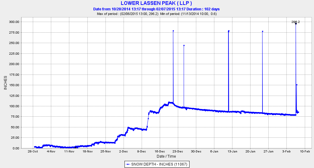
Surprisingly, the Shasta site has also now passed the California Cooperative Snow Surveys telemetry site on Lassen Peak at 8250 ft near Lake Helen for the deepest current snowpack of any measurement site in California. The Lassen site had settled from its late-December high of almost 110" to barely 80" prior to this storm, and only got about 10" new snow yesterday followed by rain, leaving the depth at about 86". Here is the snowdepth at Lassen over this season (ignore the 200+" data glitches), of particular note is the almost complete lack of snowfall from December 21 throughout the entire month of January and up to yesterday:
Overall, the Lyman Lake SNOTEL site at 5980 ft in the North Cascades still has the deepest snowpack of any measurement site in the United States as far as I know, with a mix of snow and rain during the past 2 days and perhaps a foot of new, with 106" on the ground as of midday Saturday. Its closest competitors in the Cascades are the Brown Top SNOTEL (5830 ft) in the North Cascades which stayed mostly snow despite temps well above freezing and got over 20" new bringing it up to 97", along with Harts Pass SNOTEL (6490 ft) which stayed mostly snow but didn't get much precip, and now has 87". In the Rockies, the Moss Peak (6780 ft), North Fork Jocko (6330 ft), and Noisy Basin (6040 ft) SNOTEL sites in Montana all have about 87-90", while the Grand Targhee SNOTEL (9260 ft) in Wyoming had 94" this morning before suddenly dropping several inches.
Update 08Feb2015: A high-elevation telemetry site in British Columbia has passed Lyman Lake over the past couple of days, and is now the clear leader in snowdepth among telemetry sites in North America as far as I can find: the Redfish Creek BCRFC site at 6840 ft in the Selkirk Mountains, located on the southern border of Kokanee Glacier Provincial Park just NW of Kootenay Lake. This is the 2nd highest snow telemetry site in BC, and has stayed all-snow during this atmospheric river event with temps remaining just below freezing. It had 96" of snowdepth on the morning of February 5, but has since received over 8" of snow-water (probably 4-5 ft of snowfall) bringing the depth up to almost 130" as of midday Sunday, February 8. This is the greatest snowdepth at any telemetry site in North America thus far this season that I've been able to find. A few other BCRFC telemetry sites also topped 100" over the past couple days, Mount Cook (5160 ft) and Azure River (5330 ft) located about 200 miles farther north in the Cariboo Mountains, and Tsai Creek (4490 ft) located just east of Terrace in the Coast Mountains over 400 miles NNW of Vancouver, but all have since settled back below that mark as of midday Sunday. (Link to view the last 7 days data at all 4 of these sites .)
There's one more major atmospheric river to come during the current storm cycle, which actually looks slightly more promising for snowfall than what has already passed during the last 2 days. Here's the prediction from a few days ago for total precip during this storm cycle through Tuesday afternoon, with max amounts of 16-18" in the Olympics and the Klamath Mountains of northern California:
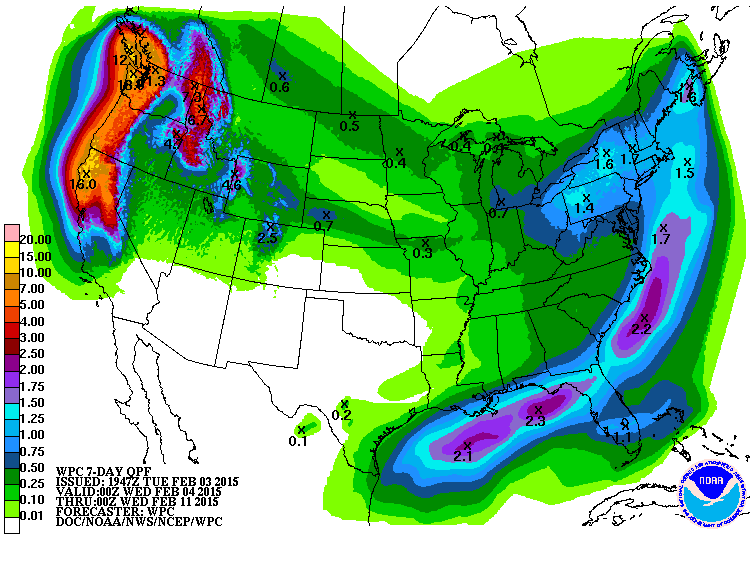
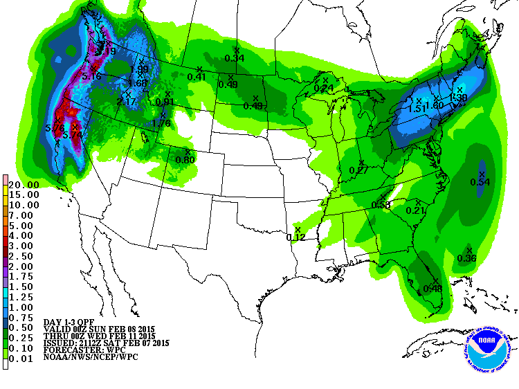
And here's the current forecast for what's still to come over the next 72 hours through Tuesday afternoon, with max precip of over 5" in the south Washington Cascades and northern California:
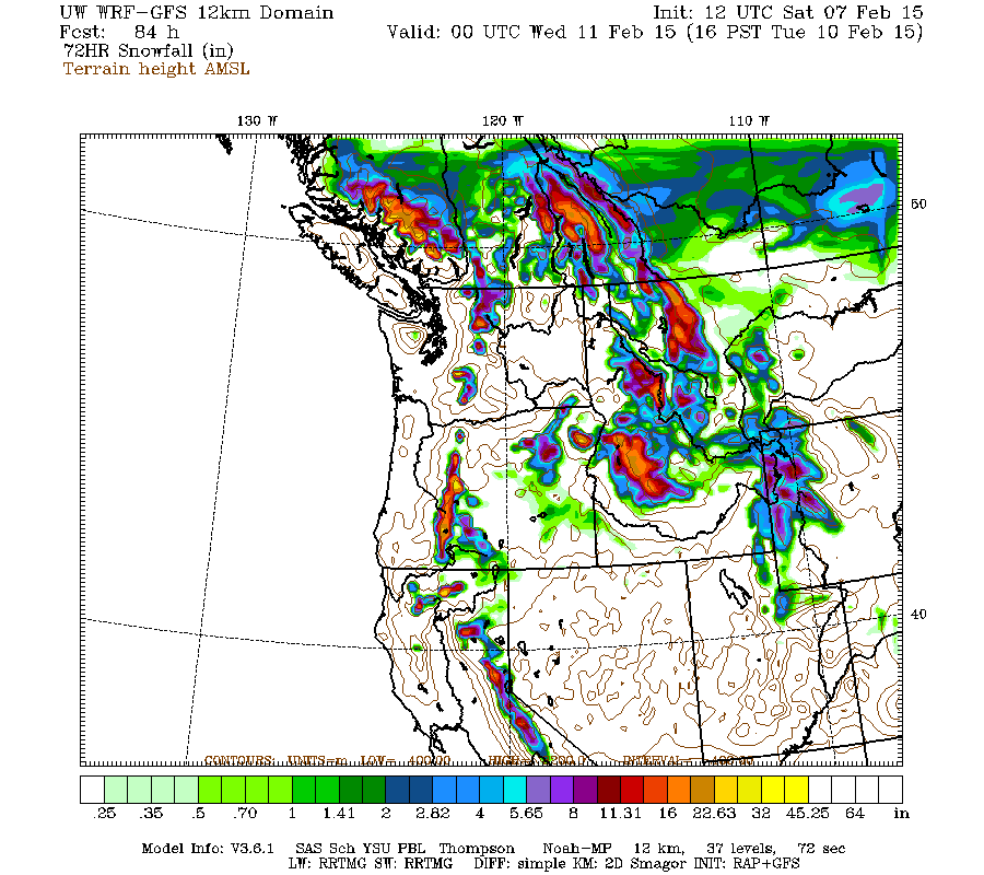
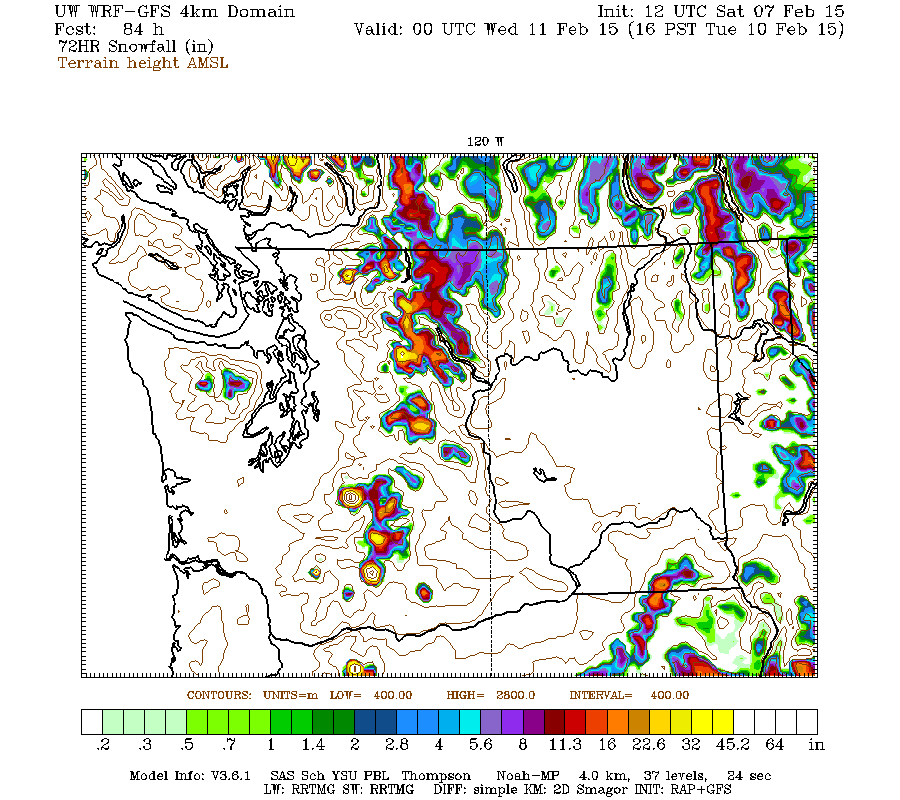
The high-resolution UW WRF-GFS model is predicting new snowfall amounts of up to 1-4 ft over the next 72 hours through Tuesday afternoon for the entire Cascade Range at sufficient altitudes (mostly above 5000-6000 ft), with amounts up to 1-2 ft extending through the Sierra Nevada:
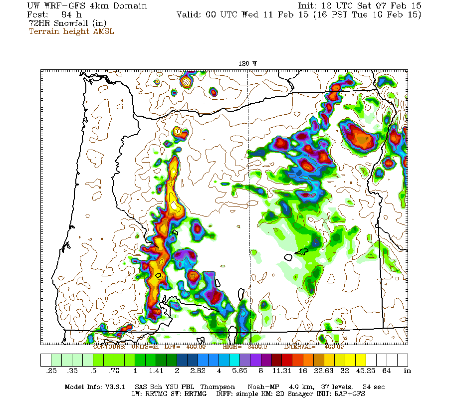
Higher resolution version of that, showing the Pacific Northwest and also zoomed in on Washington and Oregon:
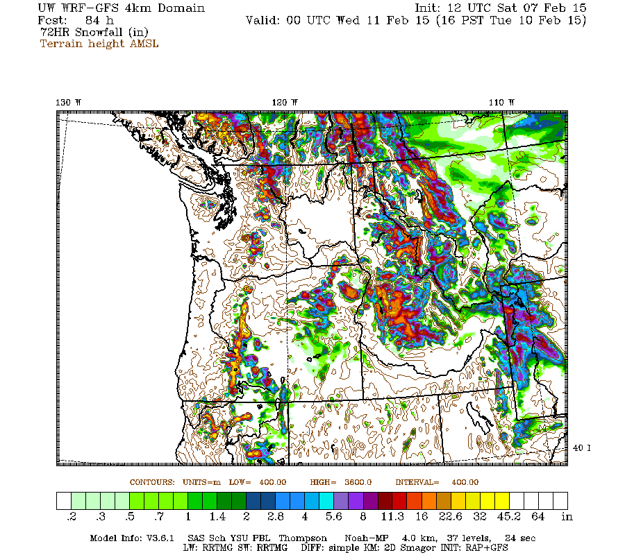
Maximum amounts of 4+ ft (marked by white inside yellow) are shown on Mount Baker, Glacier Peak, Rainier, Adams, and Saint Helens in Washington, plus Mount Hood, Jefferson, and the Three Sisters in Oregon:
Hopefully that should provide another much-needed boost to the snowpack, even if lower elevations will miss out yet again.
Lassen Peak CA reaches 100" snowdepth!! 17Dec2014
Lyman Lake SNOTEL hits 100" snowdepth!?! 05Jan2015
[hr]I'm still actively looking for positive snowpack news amid all the gloom and rain and negativity so far during this highly unusual season in the Pacific Northwest and the entire West Coast. Despite a snowpack which remains well below-normal at almost all measurement sites, making it thus far the worst season since 2005 in the Northwest, it's really nowhere near the record lows of 2005 or 1977. And the ski conditions were actually good to excellent throughout most of January as long as one went to the right places on the numerous sunny days (awesome south-facing corn from 6000 to as high as 11000 ft on many of the volcanoes from Rainier all the way south to Shasta and Lassen, outstanding smooth fast empty groomers at Crystal, etc.), and avoided obvious pitfalls like non-south-facing slopes and cloudy days and places with clearly inadequate snowpack.
So here is some more good news in the midst of yet another series of strong, wet, and warm atmospheric rivers: Mount Shasta Old Ski Bowl at 7600 ft just received 3 ft of new snow in a 24-hour period ending around 1am on Saturday, February 7, with snowdepth increasing from 60" to 92" over that period and about 4.5" of precip falling. About 24" of new snow fell in 12 hours from 3am to 3pm Friday during the most intense phase of the storm:
Lower down on Mount Shasta, the CCSS telemetry site at Sand Flat at 6750 ft also got over 2 ft of new snow in 24 hours, with snowdepth nearly doubling from 27" to 53", and there was 5" new down to the base of the Mount Shasta Ski Park at 5500 ft, which fell atop mostly bare ground at the closed ski area. Here is the snowdepth at Sand Flat over this season, unfortunately there was a data outage during the huge December snowstorm, but thankfully the site came back online afterwards:
A bit of new snow even fell down to about 4500 ft at Lassen and Shasta as colder air got pulled in around the low on Friday, while frustratingly the snow level still remained higher than that at 6000-7000 ft over much of the Washington Cascades and northern Oregon Cascades as much warmer air ended up farther north, very similar to what happened in the huge mid-December storm which dumped 4-5 ft in 36 hours on Lassen and Shasta. The region of heavy snowfall this time extended north through most of the southern Oregon Cascades as far north as Mount Bachelor, with 11-14" new reported in 24 hours at Mount Bachelor's 6300 and 7300 ft measurement sites, while Crater Lake got about 22" at the Crater Lake Rim telemetry site (7050 ft) and 18" at Crater Lake Park HQ (6400 ft) in 36 hours. There was also 19" new at Mount Ashland ski area (6500 ft) in the Siskiyous, allowing that community-owned non-profit ski area to reopen after a month-long closure due to lack of snow.
The current depth of over 90" at Mount Shasta Old Ski Bowl is just about 100% of normal for this date, although this telemetry site was only installed in December 2002, so the period of record is quite short. And it's astronomically better than last year, which had only 4" on the ground (!!) on 06Feb2014 prior to the huge February storm cycle . Yes, last year Shasta and Lassen were mostly bare ground even at high elevations into early February, an unprecedented situation in the historical record extending back over 80 years.
Surprisingly, the Shasta site has also now passed the California Cooperative Snow Surveys telemetry site on Lassen Peak at 8250 ft near Lake Helen for the deepest current snowpack of any measurement site in California. The Lassen site had settled from its late-December high of almost 110" to barely 80" prior to this storm, and only got about 10" new snow yesterday followed by rain, leaving the depth at about 86". Here is the snowdepth at Lassen over this season (ignore the 200+" data glitches), of particular note is the almost complete lack of snowfall from December 21 throughout the entire month of January and up to yesterday:
Overall, the Lyman Lake SNOTEL site at 5980 ft in the North Cascades still has the deepest snowpack of any measurement site in the United States as far as I know, with a mix of snow and rain during the past 2 days and perhaps a foot of new, with 106" on the ground as of midday Saturday. Its closest competitors in the Cascades are the Brown Top SNOTEL (5830 ft) in the North Cascades which stayed mostly snow despite temps well above freezing and got over 20" new bringing it up to 97", along with Harts Pass SNOTEL (6490 ft) which stayed mostly snow but didn't get much precip, and now has 87". In the Rockies, the Moss Peak (6780 ft), North Fork Jocko (6330 ft), and Noisy Basin (6040 ft) SNOTEL sites in Montana all have about 87-90", while the Grand Targhee SNOTEL (9260 ft) in Wyoming had 94" this morning before suddenly dropping several inches.
Update 08Feb2015: A high-elevation telemetry site in British Columbia has passed Lyman Lake over the past couple of days, and is now the clear leader in snowdepth among telemetry sites in North America as far as I can find: the Redfish Creek BCRFC site at 6840 ft in the Selkirk Mountains, located on the southern border of Kokanee Glacier Provincial Park just NW of Kootenay Lake. This is the 2nd highest snow telemetry site in BC, and has stayed all-snow during this atmospheric river event with temps remaining just below freezing. It had 96" of snowdepth on the morning of February 5, but has since received over 8" of snow-water (probably 4-5 ft of snowfall) bringing the depth up to almost 130" as of midday Sunday, February 8. This is the greatest snowdepth at any telemetry site in North America thus far this season that I've been able to find. A few other BCRFC telemetry sites also topped 100" over the past couple days, Mount Cook (5160 ft) and Azure River (5330 ft) located about 200 miles farther north in the Cariboo Mountains, and Tsai Creek (4490 ft) located just east of Terrace in the Coast Mountains over 400 miles NNW of Vancouver, but all have since settled back below that mark as of midday Sunday. (Link to view the last 7 days data at all 4 of these sites .)
There's one more major atmospheric river to come during the current storm cycle, which actually looks slightly more promising for snowfall than what has already passed during the last 2 days. Here's the prediction from a few days ago for total precip during this storm cycle through Tuesday afternoon, with max amounts of 16-18" in the Olympics and the Klamath Mountains of northern California:
And here's the current forecast for what's still to come over the next 72 hours through Tuesday afternoon, with max precip of over 5" in the south Washington Cascades and northern California:
The high-resolution UW WRF-GFS model is predicting new snowfall amounts of up to 1-4 ft over the next 72 hours through Tuesday afternoon for the entire Cascade Range at sufficient altitudes (mostly above 5000-6000 ft), with amounts up to 1-2 ft extending through the Sierra Nevada:
Higher resolution version of that, showing the Pacific Northwest and also zoomed in on Washington and Oregon:
Maximum amounts of 4+ ft (marked by white inside yellow) are shown on Mount Baker, Glacier Peak, Rainier, Adams, and Saint Helens in Washington, plus Mount Hood, Jefferson, and the Three Sisters in Oregon:
Hopefully that should provide another much-needed boost to the snowpack, even if lower elevations will miss out yet again.
Please Log in or Create an account to join the conversation.
- lrudholm
-
- User
-
Less
More
- Posts: 83
- Thank you received: 0
11 years 2 months ago #223757
by lrudholm
Replied by lrudholm on topic Re: Mt Shasta gets 3 ft new snow in 24 hrs!! 07Feb2015
Yep, good up high, but you have to work for it ")
Please Log in or Create an account to join the conversation.
- powhound
-
- User
-
Less
More
- Posts: 52
- Thank you received: 0
11 years 2 months ago #223765
by powhound
Replied by powhound on topic Re: Mt Shasta gets 3 ft new snow in 24 hrs!! 07Feb2015
I hate to tell you Amar, but corn in January is not good to excellent :
Please Log in or Create an account to join the conversation.
- Floater
-
- User
-
Less
More
- Posts: 23
- Thank you received: 0
11 years 2 months ago #223778
by Floater
Replied by Floater on topic Re: Mt Shasta gets 3 ft new snow in 24 hrs!! 07Feb2015
This is what is weird this is happening in a year that is not an El Nino. We should be fearful of that. We had the warmest December on record. We had the 5th warmest January on record. February is just as amazing. This could become the warmest winter on record. I call it for the months of Dec through March the winter ski season. For the last decade despite some great ski years Januarys have been unusually warm. Something weird is happening with our weather.
I really did not become aware of it until the last two La Ninya cycles. We had great skiing lots of fresh snow but very few major lowland snow events. La Ninyas in the past were marked by lots of lowland snow events and longer lowland cold spells. In the past there is a lake next to us where we would be able to ice skate for a week or so. That has not happened in years. It may get a thin ice cover, but is too dangerous to try it. No our weather is changing big time. Tiger Pass used to be a real hassle due to snowfall to use in La Ninya years getting from my house in Port Orchard to Snoq. During the last La Ninyas it was a breeze most of the time getting through there. Despite the good skiing I was worried real worried.
This year I believe is a harbinger of things to come. Yes we are still getting snow but it is in intense short periods and when it is good it is awesome. Last year the season of good winter skiing was all compressed into a four week period. Oh and the January just plain sucked last year as well. All we can hope for is another weird redemption like last year. This is not your stable jet stream of the past bringing us cool wet weather to the lowlands and moderate snowfall to the mountains high 20s to low 30s for days on end during normal years. Now it is very warm periods punctuated by very intense snowfalls in shorter periods. The problem is for how much longer folks will we even get a snowpack. I would be worried.
I also think our glaciers are rapidly decreasing. I made a climb of Glacier Peak two years ago in August by a route I used 45 years ago. I was with a friend who was a mountaineer and who had done over 50 years of climbing in the Cascades. I personally am not a mountaineer. We were aghast at how much the glaciers have shrunk. They almost all have disappeared or markedly shrunk in size. It was so sad to see. I actually think this process although expected is actually accelerating.
Here is the sad thing we need the pack not so much for face shots and floating, but for water to drink and for our farms and hydro. No this is scary stuff. Our weather is getting like the SF Bay area in the winter lots of inversions heavy fog and then the occasional major rain event sometimes cold but often a pineapple. What is also scary is Northern Cali is getting like Suthern Cali use to be.
I will be honest with you folks you can look at tons of data, but the times they are a changin. Take it from someone who has lived in this area for 64 of his 66 years. Three or four years ago in what became a good snow year in January I was in a Tshirt on the top of what is left of Mount St Helens in January. Every year I have done that since then at Camp Muir and it is frequent. That happened in the past but rarely. For example 1981, but not for so many days in a row.
Buying a lawnmower and will be mowing next weekend. It is the earliest start ever at this house in 40 years and I hate mowing the lawn but it is growing like crazy. Go figure folks ....... if you can not see it happenin you are taking way too many 4:20s....LOL.
Please Log in or Create an account to join the conversation.
- aaron_wright
-
- User
-
Less
More
- Posts: 429
- Thank you received: 0
11 years 2 months ago #223785
by aaron_wright
Replied by aaron_wright on topic Re: Mt Shasta gets 3 ft new snow in 24 hrs!! 07Feb2015
The idea of a "January Thaw" has been around forever. I'm not as old as Floater, I'm 47, but I grew up in Western WA and I don't remember big winters except for rain. I grew up on a lake and as a kid we were lucky if we could skate on it once in five years. Big lowland snowstorms were the exception not the rule.
Yes the climate is changing, but things aren't that much different and don't fall very far outside historical norms except for a few outliers years. It's been accepted that Cascade glaciers have been receding for some time. A decade or so of some really good winters fools us into thinking we'll be skiing powder every day from November through April and that it is normal.
Yes the climate is changing, but things aren't that much different and don't fall very far outside historical norms except for a few outliers years. It's been accepted that Cascade glaciers have been receding for some time. A decade or so of some really good winters fools us into thinking we'll be skiing powder every day from November through April and that it is normal.
Please Log in or Create an account to join the conversation.
- HillsHaveEyes
-
- User
-
Less
More
- Posts: 32
- Thank you received: 0
11 years 2 months ago #223786
by HillsHaveEyes
Replied by HillsHaveEyes on topic Re: Mt Shasta gets 3 ft new snow in 24 hrs!! 07Feb2015
Bring back the Little Ice Age!
Please Log in or Create an account to join the conversation.