- Posts: 635
- Thank you received: 0
Lassen Peak CA reaches 100" snowdepth!! 17Dec2014
- Amar Andalkar
- [andalkar]
-
 Topic Author
- Offline
- Premium Member
-

Less
More
17 Dec 2014 17:19 - 22 Dec 2014 18:43 #223260
by Amar Andalkar
Lassen Peak CA reaches 100" snowdepth!! 17Dec2014 was created by Amar Andalkar
Given all the negative gloom-and-doom talk about the Northwest's very wet but not-very-snowy fall of 2014, with snow depths at record or near-record lows for December 15 at many sites and many people wondering (again) if the entire season will be a disaster, I've decided to post some positive snow news instead.
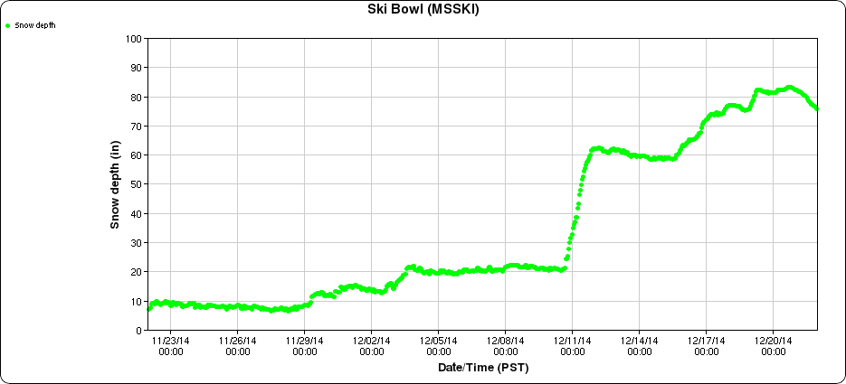
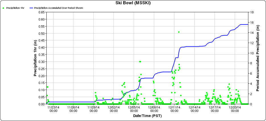
Following nearly 7 ft of new snowfall over the past 7 days, the snowdepth on Lassen Peak in the California Cascades topped 100" this morning at the California Cooperative Snow Surveys telemetry site near Lake Helen at 8250 ft. Current snowdepth is 104" as of Wednesday afternoon, December 17, an increase of 60" from 7 days earlier, and about 150% of normal for this date. This is (almost certainly, unless I really missed something someplace) by far the deepest snowpack of any measurement site in North America now, with its closest competitor being Mount Shasta Old Ski Bowl at 7600 ft which reached 74" today, an increase of 53" there in 7 days, and also about 150% of normal.
The largest snowdepths at any snow telemetry sites in the Sierra Nevada, Rockies, Tetons, or BC appear to be in the 50-60" range now, although unfortunately there is no easy way to get a list of which sites have the largest snowdepth, other than manually checking the data from a large number of SNOTEL, CCSS, and BCRFC sites which might be potential candidates for large snowdepths (a huge annoyance, so I could have missed some sites). The largest I could find were Tenquille Lake (5500 ft) north of Pemberton BC with 57", Leavitt Lake (9600 ft) in the Sierra with 57", and Grand Targhee (9260 ft) in Wyoming with 54".
How did the snowpack on Lassen and Shasta end up so far above normal now? Mostly due to a single huge snowstorm last Wednesday evening to Friday morning, which produced a 45" increase in snowdepth in 36 hours from 44" to 89" at the 8250 ft Lassen site. This implies an actual new snowfall of closer to 60" given settlement and compaction of the previous snowpack, and about 8" of precip was recorded nearby at Mineral (5000 ft) during that same period. Over 70 miles away on Mount Shasta, the same storm produced a 42" increase in snowdepth in 36 hours from 21" to 63" at the 7600 ft site, implying about 50" of actual new snowfall with precip of about 6" at nearby lower elevation sites.
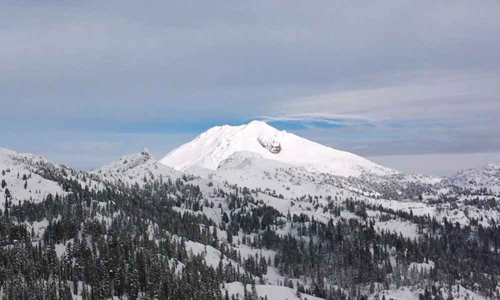
[size=small]Lassen Peak with a wispy lenticular cloud, seen from the flanks of Brokeoff Mountain a few days after the huge snowstorm. (screen capture from this video by my friends shred and snoholic)[/size]
That storm was the intense windstorm which capped a series of 3 wet systems last week, but its track and rapid intensification as it moved northward along the Northwest coast produced some unusual effects (and unwelcome ones in the Northwest). A few inches of new snow fell down to below 4500 ft at Lassen and 5000 ft at Shasta as colder air got pulled in around the low on Thursday evening, while frustratingly the snow level still remained higher than that at 6000-7000 ft over much of the Washington Cascades and northern Oregon Cascades as much warmer air ended up farther north closer to the occluding low. The Sierra got as much as 12-24" new above 7000-8000 ft on Thursday into Friday, but unfortunately Washington and Oregon recorded only a few inches of new snow even at the highest measurement sites once the snow level finally dropped to 4000-5000 ft at the tail end.
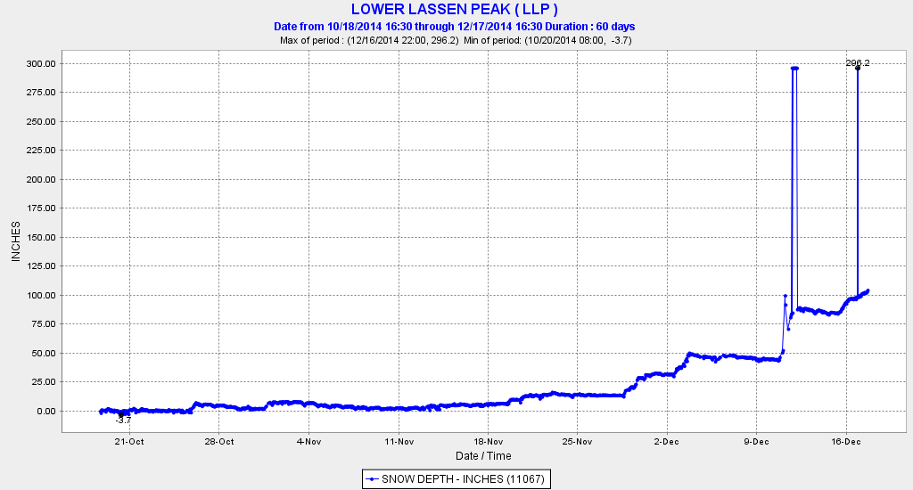
Somewhat weaker storms the last 2 days have brought an additional 18-24" of new snowfall to both the Lassen and Shasta sites, and more snowfall is expected over the next 2-3 days. Here is a plot of snowfall at the Lassen site throughout this fall (ignore the 296" data glitches), showing the huge storm last week and further snowfall this week:
For those who aren't well versed in Cascades snow climatology, it may come as a surprise that the 8250 ft Lassen Peak site has by far the greatest average snowdepth of any measurement site in California, exceeding any site in the Sierra Nevada or on Mount Shasta by over 30%. In fact, its average April 1 snowdepth of 177" (with records back to 1930) is essentially equal to that of both Mount Rainier Paradise (5400 ft) and Mount Baker Ski Area (4200 ft), which each average 175" on April 1 and are famed as the only sites anywhere in the world at which more than 1000" of snowfall has been recorded in any year. Obviously the Lassen site appears to be unfairly much higher, but the comparison is actually more fair than it seems, as all 3 sites are located in open meadows about 1000 ft below local treeline. The average annual snowfall at the Rainier and Baker sites is about 650-680" inches (depending on period of record), implying a comparable average annual snowfall at the Lassen site (which has no daily snowfall records).
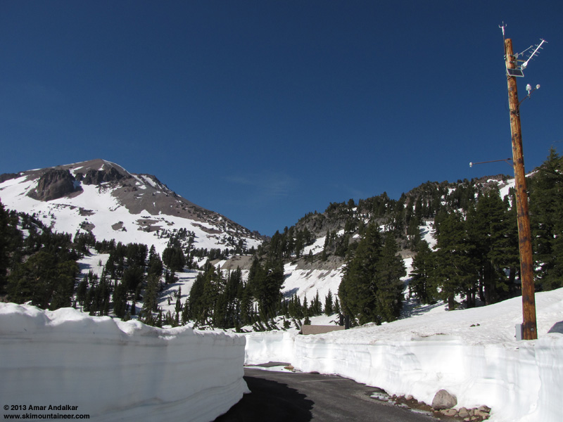
Just for fun, here is some more info about the Lassen telemetry site. This picture of the site (with Lassen Peak at left) is from early June 2013, showing two independent snowdepth sensors mounted on the same telephone pole, at 297" and 357" above ground level (the tilt of the pole is due to the camera lens, and the parking lot is not plowed during the winter, typically until June or even July in fat years):
The Lassen telemetry site was installed in November 2003, and is co-located with a manual snow course site which has monthly data back to 1930 (February 1, March 1, April 1, and May 1, plus January 1 from 1973-1997 only). The current snow depth of over 100" is the earliest that threshold has been reached during those 12 seasons since 2003, although several years have topped 100" before January 1. The manual snow course data shows January 1 snowdepths over 100" in about 25% of the seasons from 1973-1997 for which January 1 data is available.
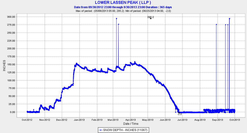
Here are plots of Lassen's hourly snowdepth for several entire seasons, since the CCSS website has the very nice capability to easily generate these. Sadly there was a data outage at the Lassen site for the entire 2013-14 season (the driest in California since 1976-77), but here is the previous drought season of 2012-13. Of particular note is the huge snowstorm which brought about 10 ft of snowfall and a 75" increase in snowdepth to reach 155" during the 3rd week of December, followed by minimal snowfall throughout the entire winter until March:
The first year of the current California drought was 2011-12, but prior to that was the amazing 2010-11 season, with huge snowdepths throughout the West Coast and record snowfalls at several Cascade and Sierra ski areas. At Lassen the snowdepth reached 275" in late March, and a cool snowy spring kept the snowpack fat, with 230" still on the ground in early June (!!) and snowpack lingering into the final days of August:
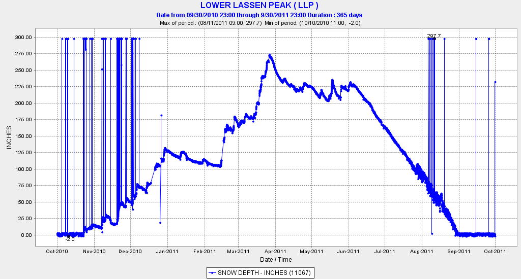
(The 297" numbers are data glitches which reveal the height of the sensor above ground, ignore them.)
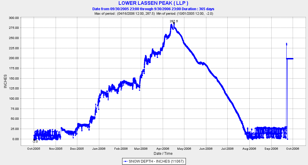
Another huge season was 2005-6, which also set snowfall records at some Sierra ski areas. The Lassen snowpack peaked at 287" in mid-April, but a more normal spring and summer resulted in 180" by the start of June and melt-out by the end of July, a month earlier than 2011:
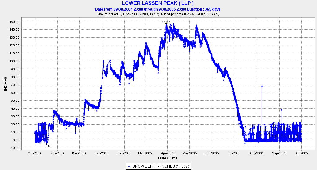
The previous 2004-5 season was well below normal reaching only 148", but a snowy spring still found over 100" on the ground in early June:
That 2004-5 season was also the worst for snowfall in most of the Washington and Oregon Cascades since 1940-41, and marked the only season in 90+ years of records that Mount Rainier Paradise failed to reach 100" of snow depth, topping out at 95" in mid-April. Which brings us to the current snowpack situation in the Northwest, which some have feared may be heading for a repeat of that brutal season. In contrast to the California Cascades where the snowpack is now well above normal (at least at higher elevations), Washington and Oregon are not doing well at any elevations which have measurement sites (with one exception noted below). Here is the latest CLISNO report from NWAC ( current and older reports are archived here ), showing the bleak situation with record or near-record lows at several sites:
CLIMATOLOGICAL SNOWDEPTH INFORMATION
NORTHWEST AVALANCHE CENTER SEATTLE WASHINGTON
DAY 15 MONTH 12 YEAR 2014
DATA IN INCHES, -99 DENOTES MISSING DATA
CURRENT CLIMATE PER CENT LAST THRU 2013 THRU 2013
DEPTH AVERAGE OF NORMAL YEAR MAX/YEAR MIN/YEAR
HURRICANE 4 48 8 10 83/2006 10/2013
MT BAKER 6 68 9 43 168/1948 16/1976
STEVENS 11 44 25 26 80/1973 5/1976
SNOQUALMIE 6 36 17 9 116/1948 0/1976
STAMPEDE -99 42 -99 10 119/1948 9/1976
MISSION 2 23 9 14 49/2006 4/1975
CRYSTAL 2 34 6 9 72/1996 9/2013
PARADISE 22 68 32 42 170/1948 4/1976
WHITE PASS 0 28 0 4 73/1996 2/1989
TIMBERLINE 11 63 17 27 145/1984 0/1976
MEADOWS 2 54 4 24 118/1984 8/1989
THIS TABLE PRODUCED ON THE 1ST AND 15TH BETWEEN 15 NOVEMBER AND 1 MAY.
AVERAGES, MAXIMUMS AND MINIMUMS EARLY AND LATE IN THE SEASON MAY BE
INACCURATE DUE TO LIMITED DATA.
IF THERE IS TIE FOR THE MAXIMUM OR MINIMUM SNOW DEPTH THEN THE LATEST
YEAR IS INDICATED.
RECORDS BEGIN: HURRICANE 1979, MT BAKER 1926, STEVENS 1939,
SNOQUALMIE 1929, STAMPEDE 1943, MISSION RIDGE 1970,
CRYSTAL 1967, PARADISE 1926, WHITE PASS 1976,
TIMBERLINE 1973, MT HOOD MEADOWS 1974.
NOTE: NRCS DATA USED AT STAMPEDE STARTING 2006-2007 SEASON.
The largest current snowdepth at any site in Washington or Oregon is at the Harts Pass SNOTEL at 6500 ft, which had 52" yesterday (snowdepth currently not reporting) and had reached a seasonal maximum thus far of 70" on November 28, after another Pineapple Express which stayed mostly snow at this high-elevation inland site. The next day on November 29, the second major cold snap of the fall sent temperatures plummeting to -13 °F at that site, quite representative of the wild swings from warm and wet to very cold and dry several times this fall. Normal values for snowdepth on December 15 or 17 are not known for the Harts Pass site, but it is almost certainly above 100% of normal at this time, and the snow water equivalent there is about 115% of normal for this date. The fact that Harts Pass has 52" while the normally much-snowier Mount Baker Ski Area site has only 6" is quite stunning, and a perfect reflection of what has gone wrong thus far this season.
The next 3 plots summarize the story of the fall season thus far in the Northwest, very wet but not-very-snowy at the elevations which have measurement sites or ski areas. Here is a plot of current snowdepths from the SNOTEL network, which shows almost nothing over 48" anywhere in the western US and many sites in the Northwest with zero or near-zero amounts:
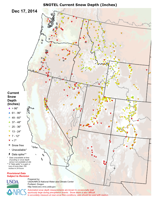
(Unfortunately most sites in California are not included in this plot, since they are in the separate state-run CCSS network, and sites in BC and Alberta are obviously not included either. Too bad that agencies can't properly share all this data with each other.)
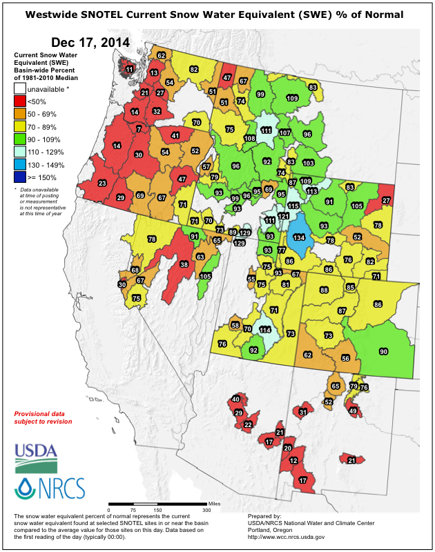
Current snowpack (snow water equivalent) as a percent of normal, looking bleak in the Northwest:
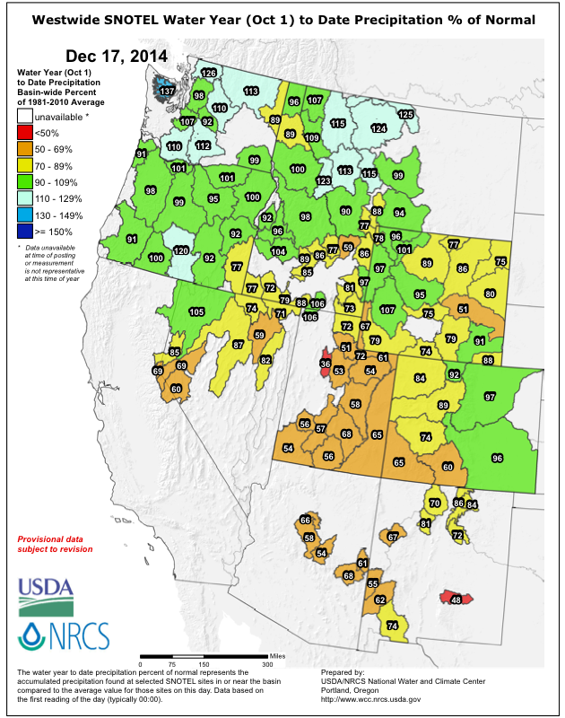
Water year to date precipitation (since Oct 1) as a percent of normal, which in sharp contrast to SWE is normal to above normal throughout the Northwest:
What does the rest of the season hold? It's hard to say, although there are no indications that it will be similar to 2004-5 or to any other season (such "season similarity" comparisons have no statistical validity for determining expected snowfall and snowpack). Although a repeat of that type of extreme low snowpack is possible, it is highly unlikely, with less than a few percent chance statistically of matching that year's lows by spring. The same very-low early-season snowpack situation last year resulted in quite a good snow year overall, quite close to normal values by March and April, and also produced one of my best ski mountaineering seasons ever. See this post from 366 days ago for more discussion of the implications of low early-season snowpack:
How unusual is the current low PNW snowpack?
Following nearly 7 ft of new snowfall over the past 7 days, the snowdepth on Lassen Peak in the California Cascades topped 100" this morning at the California Cooperative Snow Surveys telemetry site near Lake Helen at 8250 ft. Current snowdepth is 104" as of Wednesday afternoon, December 17, an increase of 60" from 7 days earlier, and about 150% of normal for this date. This is (almost certainly, unless I really missed something someplace) by far the deepest snowpack of any measurement site in North America now, with its closest competitor being Mount Shasta Old Ski Bowl at 7600 ft which reached 74" today, an increase of 53" there in 7 days, and also about 150% of normal.
The largest snowdepths at any snow telemetry sites in the Sierra Nevada, Rockies, Tetons, or BC appear to be in the 50-60" range now, although unfortunately there is no easy way to get a list of which sites have the largest snowdepth, other than manually checking the data from a large number of SNOTEL, CCSS, and BCRFC sites which might be potential candidates for large snowdepths (a huge annoyance, so I could have missed some sites). The largest I could find were Tenquille Lake (5500 ft) north of Pemberton BC with 57", Leavitt Lake (9600 ft) in the Sierra with 57", and Grand Targhee (9260 ft) in Wyoming with 54".
How did the snowpack on Lassen and Shasta end up so far above normal now? Mostly due to a single huge snowstorm last Wednesday evening to Friday morning, which produced a 45" increase in snowdepth in 36 hours from 44" to 89" at the 8250 ft Lassen site. This implies an actual new snowfall of closer to 60" given settlement and compaction of the previous snowpack, and about 8" of precip was recorded nearby at Mineral (5000 ft) during that same period. Over 70 miles away on Mount Shasta, the same storm produced a 42" increase in snowdepth in 36 hours from 21" to 63" at the 7600 ft site, implying about 50" of actual new snowfall with precip of about 6" at nearby lower elevation sites.
[size=small]Lassen Peak with a wispy lenticular cloud, seen from the flanks of Brokeoff Mountain a few days after the huge snowstorm. (screen capture from this video by my friends shred and snoholic)[/size]
That storm was the intense windstorm which capped a series of 3 wet systems last week, but its track and rapid intensification as it moved northward along the Northwest coast produced some unusual effects (and unwelcome ones in the Northwest). A few inches of new snow fell down to below 4500 ft at Lassen and 5000 ft at Shasta as colder air got pulled in around the low on Thursday evening, while frustratingly the snow level still remained higher than that at 6000-7000 ft over much of the Washington Cascades and northern Oregon Cascades as much warmer air ended up farther north closer to the occluding low. The Sierra got as much as 12-24" new above 7000-8000 ft on Thursday into Friday, but unfortunately Washington and Oregon recorded only a few inches of new snow even at the highest measurement sites once the snow level finally dropped to 4000-5000 ft at the tail end.
Somewhat weaker storms the last 2 days have brought an additional 18-24" of new snowfall to both the Lassen and Shasta sites, and more snowfall is expected over the next 2-3 days. Here is a plot of snowfall at the Lassen site throughout this fall (ignore the 296" data glitches), showing the huge storm last week and further snowfall this week:
For those who aren't well versed in Cascades snow climatology, it may come as a surprise that the 8250 ft Lassen Peak site has by far the greatest average snowdepth of any measurement site in California, exceeding any site in the Sierra Nevada or on Mount Shasta by over 30%. In fact, its average April 1 snowdepth of 177" (with records back to 1930) is essentially equal to that of both Mount Rainier Paradise (5400 ft) and Mount Baker Ski Area (4200 ft), which each average 175" on April 1 and are famed as the only sites anywhere in the world at which more than 1000" of snowfall has been recorded in any year. Obviously the Lassen site appears to be unfairly much higher, but the comparison is actually more fair than it seems, as all 3 sites are located in open meadows about 1000 ft below local treeline. The average annual snowfall at the Rainier and Baker sites is about 650-680" inches (depending on period of record), implying a comparable average annual snowfall at the Lassen site (which has no daily snowfall records).
Just for fun, here is some more info about the Lassen telemetry site. This picture of the site (with Lassen Peak at left) is from early June 2013, showing two independent snowdepth sensors mounted on the same telephone pole, at 297" and 357" above ground level (the tilt of the pole is due to the camera lens, and the parking lot is not plowed during the winter, typically until June or even July in fat years):
The Lassen telemetry site was installed in November 2003, and is co-located with a manual snow course site which has monthly data back to 1930 (February 1, March 1, April 1, and May 1, plus January 1 from 1973-1997 only). The current snow depth of over 100" is the earliest that threshold has been reached during those 12 seasons since 2003, although several years have topped 100" before January 1. The manual snow course data shows January 1 snowdepths over 100" in about 25% of the seasons from 1973-1997 for which January 1 data is available.
Here are plots of Lassen's hourly snowdepth for several entire seasons, since the CCSS website has the very nice capability to easily generate these. Sadly there was a data outage at the Lassen site for the entire 2013-14 season (the driest in California since 1976-77), but here is the previous drought season of 2012-13. Of particular note is the huge snowstorm which brought about 10 ft of snowfall and a 75" increase in snowdepth to reach 155" during the 3rd week of December, followed by minimal snowfall throughout the entire winter until March:
The first year of the current California drought was 2011-12, but prior to that was the amazing 2010-11 season, with huge snowdepths throughout the West Coast and record snowfalls at several Cascade and Sierra ski areas. At Lassen the snowdepth reached 275" in late March, and a cool snowy spring kept the snowpack fat, with 230" still on the ground in early June (!!) and snowpack lingering into the final days of August:
(The 297" numbers are data glitches which reveal the height of the sensor above ground, ignore them.)
Another huge season was 2005-6, which also set snowfall records at some Sierra ski areas. The Lassen snowpack peaked at 287" in mid-April, but a more normal spring and summer resulted in 180" by the start of June and melt-out by the end of July, a month earlier than 2011:
The previous 2004-5 season was well below normal reaching only 148", but a snowy spring still found over 100" on the ground in early June:
That 2004-5 season was also the worst for snowfall in most of the Washington and Oregon Cascades since 1940-41, and marked the only season in 90+ years of records that Mount Rainier Paradise failed to reach 100" of snow depth, topping out at 95" in mid-April. Which brings us to the current snowpack situation in the Northwest, which some have feared may be heading for a repeat of that brutal season. In contrast to the California Cascades where the snowpack is now well above normal (at least at higher elevations), Washington and Oregon are not doing well at any elevations which have measurement sites (with one exception noted below). Here is the latest CLISNO report from NWAC ( current and older reports are archived here ), showing the bleak situation with record or near-record lows at several sites:
CLIMATOLOGICAL SNOWDEPTH INFORMATION
NORTHWEST AVALANCHE CENTER SEATTLE WASHINGTON
DAY 15 MONTH 12 YEAR 2014
DATA IN INCHES, -99 DENOTES MISSING DATA
CURRENT CLIMATE PER CENT LAST THRU 2013 THRU 2013
DEPTH AVERAGE OF NORMAL YEAR MAX/YEAR MIN/YEAR
HURRICANE 4 48 8 10 83/2006 10/2013
MT BAKER 6 68 9 43 168/1948 16/1976
STEVENS 11 44 25 26 80/1973 5/1976
SNOQUALMIE 6 36 17 9 116/1948 0/1976
STAMPEDE -99 42 -99 10 119/1948 9/1976
MISSION 2 23 9 14 49/2006 4/1975
CRYSTAL 2 34 6 9 72/1996 9/2013
PARADISE 22 68 32 42 170/1948 4/1976
WHITE PASS 0 28 0 4 73/1996 2/1989
TIMBERLINE 11 63 17 27 145/1984 0/1976
MEADOWS 2 54 4 24 118/1984 8/1989
THIS TABLE PRODUCED ON THE 1ST AND 15TH BETWEEN 15 NOVEMBER AND 1 MAY.
AVERAGES, MAXIMUMS AND MINIMUMS EARLY AND LATE IN THE SEASON MAY BE
INACCURATE DUE TO LIMITED DATA.
IF THERE IS TIE FOR THE MAXIMUM OR MINIMUM SNOW DEPTH THEN THE LATEST
YEAR IS INDICATED.
RECORDS BEGIN: HURRICANE 1979, MT BAKER 1926, STEVENS 1939,
SNOQUALMIE 1929, STAMPEDE 1943, MISSION RIDGE 1970,
CRYSTAL 1967, PARADISE 1926, WHITE PASS 1976,
TIMBERLINE 1973, MT HOOD MEADOWS 1974.
NOTE: NRCS DATA USED AT STAMPEDE STARTING 2006-2007 SEASON.
The largest current snowdepth at any site in Washington or Oregon is at the Harts Pass SNOTEL at 6500 ft, which had 52" yesterday (snowdepth currently not reporting) and had reached a seasonal maximum thus far of 70" on November 28, after another Pineapple Express which stayed mostly snow at this high-elevation inland site. The next day on November 29, the second major cold snap of the fall sent temperatures plummeting to -13 °F at that site, quite representative of the wild swings from warm and wet to very cold and dry several times this fall. Normal values for snowdepth on December 15 or 17 are not known for the Harts Pass site, but it is almost certainly above 100% of normal at this time, and the snow water equivalent there is about 115% of normal for this date. The fact that Harts Pass has 52" while the normally much-snowier Mount Baker Ski Area site has only 6" is quite stunning, and a perfect reflection of what has gone wrong thus far this season.
The next 3 plots summarize the story of the fall season thus far in the Northwest, very wet but not-very-snowy at the elevations which have measurement sites or ski areas. Here is a plot of current snowdepths from the SNOTEL network, which shows almost nothing over 48" anywhere in the western US and many sites in the Northwest with zero or near-zero amounts:
(Unfortunately most sites in California are not included in this plot, since they are in the separate state-run CCSS network, and sites in BC and Alberta are obviously not included either. Too bad that agencies can't properly share all this data with each other.)
Current snowpack (snow water equivalent) as a percent of normal, looking bleak in the Northwest:
Water year to date precipitation (since Oct 1) as a percent of normal, which in sharp contrast to SWE is normal to above normal throughout the Northwest:
What does the rest of the season hold? It's hard to say, although there are no indications that it will be similar to 2004-5 or to any other season (such "season similarity" comparisons have no statistical validity for determining expected snowfall and snowpack). Although a repeat of that type of extreme low snowpack is possible, it is highly unlikely, with less than a few percent chance statistically of matching that year's lows by spring. The same very-low early-season snowpack situation last year resulted in quite a good snow year overall, quite close to normal values by March and April, and also produced one of my best ski mountaineering seasons ever. See this post from 366 days ago for more discussion of the implications of low early-season snowpack:
How unusual is the current low PNW snowpack?
Please Log in or Create an account to join the conversation.
- Pinch
- [Pinch]
-
- Offline
- Senior Member
-

Less
More
- Posts: 289
- Thank you received: 0
17 Dec 2014 19:26 #223254
by Pinch
Replied by Pinch on topic Re: Lassen Peak CA reaches 100" snowdepth!! 17Dec2014
Lots of info there!
I have been watching that Harts Pass data all Fall.
Here are a couple of data points for BC.
www.solmountain.com/ (see web cam) and gah.ca/index.php?id=10 (see web cam)
Both are currently near 72" after settling out from the last warm up.
I have personally seen a solid 6-7' sub-alpine snowpack in other areas of BC as well this season. North of Revelstoke and near Valemount. But no data stations that I know of...
I am thankful for those locations this year, given the lack of snow locally.
Please Log in or Create an account to join the conversation.
- snoholic
- [snoholic]
-
- Offline
- Junior Member
-

Less
More
- Posts: 119
- Thank you received: 1
17 Dec 2014 21:48 - 17 Dec 2014 21:55 #223261
by snoholic
Replied by snoholic on topic Re: Lassen Peak CA reaches 100" snowdepth!! 17Dec2014
I can verify, Lassen was (is) good. Go south, party on.
Please Log in or Create an account to join the conversation.
- flowing alpy
- [flowing alpy]
-
- Offline
- Platinum Member
-

Less
More
- Posts: 1272
- Thank you received: 0
18 Dec 2014 18:28 #223264
by flowing alpy
Replied by flowing alpy on topic Re: Lassen Peak CA reaches 100" snowdepth!! 17Dec2014
i'm getting an urge to travel to my first ski hill, spinning bull-wheels at lassen ski are in the early 70's. one rope one poma no lines gorgeous lodge.
Please Log in or Create an account to join the conversation.
- Dustin_B
- [Dustin_B]
-
- Offline
- New Member
-

Less
More
- Posts: 23
- Thank you received: 0
18 Dec 2014 21:58 #223268
by Dustin_B
Replied by Dustin_B on topic Re: Lassen Peak CA reaches 100" snowdepth!! 17Dec2014
And there's Mt Bachelor. 52" at 7300', although its only a total snow stake and has no telemetry.
Please Log in or Create an account to join the conversation.
- Floater
- [Floater]
-
- Offline
- New Member
-
Less
More
- Posts: 23
- Thank you received: 0
19 Dec 2014 21:29 #223278
by Floater
Replied by Floater on topic Re: Lassen Peak CA reaches 100" snowdepth!! 17Dec2014
Let's be honest things are changing. Yes last year finally produced snow but a huge portion of the season sucked until a few monster dumps in February. This one locally could be a real treat with a very skimpy snowpack. Again essentially know decent skiing before Christmas. As the decades wear on this is what you can expect more sparse snowpacks for the PNW with you having to rush out to get the goods during a week or so of big dumps.
For those of us who can remember normally when you rolled by Skykomish on the way to from mid December until Mid march there would be 3' to 5' feet on the ground. Now it is rare if the ground there even stays covered during the winter months. We are losing our lower elevation snowpack. Yep the times they are a changing. Here we sit again you better be skiing before tomorrow noon because after that another pineapple. Snoqualimie to be honest was marginal for most of last year, this year it will probably be worse. Welcome to climate change.
For those of us who can remember normally when you rolled by Skykomish on the way to from mid December until Mid march there would be 3' to 5' feet on the ground. Now it is rare if the ground there even stays covered during the winter months. We are losing our lower elevation snowpack. Yep the times they are a changing. Here we sit again you better be skiing before tomorrow noon because after that another pineapple. Snoqualimie to be honest was marginal for most of last year, this year it will probably be worse. Welcome to climate change.
Please Log in or Create an account to join the conversation.
- Amar Andalkar
- [andalkar]
-
Topic Author
- Offline
- Premium Member
-
Less
More
- Posts: 635
- Thank you received: 0
22 Dec 2014 01:20 - 22 Dec 2014 09:45 #223301
by Amar Andalkar
Replied by Amar Andalkar on topic Re: Lassen Peak CA reaches 100" snowdepth!! 17Dec2014
Just a little bit of ongoing snowpack news...
Moderate snowfall continued in the California Cascades during the next 4 days after the original post above, producing an additional foot or so of new snow and one notable milestone on Mount Shasta. The snowdepth at Mount Shasta Old Ski Bowl at 7600 ft reached 83" on December 21, which easily surpasses the maximum depth reached at any point during last season's ongoing drought. The 2013-14 season's snowdepth topped out at only 77" on April 4, 2014, about 55% of the normal early April depth of almost 140" at this site over the 12 years since it was installed. Here are plots of snowdepth and precip over the past 30 days at Mount Shasta Old Ski Bowl, showing the huge December 10-12 storm and ongoing snowfall since then:
Almost 16" of precipitation in the last 3 weeks (actually about 2" more than that, since some precip was missed by the gauge in the middle of the huge snowstorm) should go a long way toward easing drought conditions. Down in Mount Shasta city at 3500 ft, there has been about 12.5" of precip thus far in December, about 250% of the normal of 5" by this time of the month.
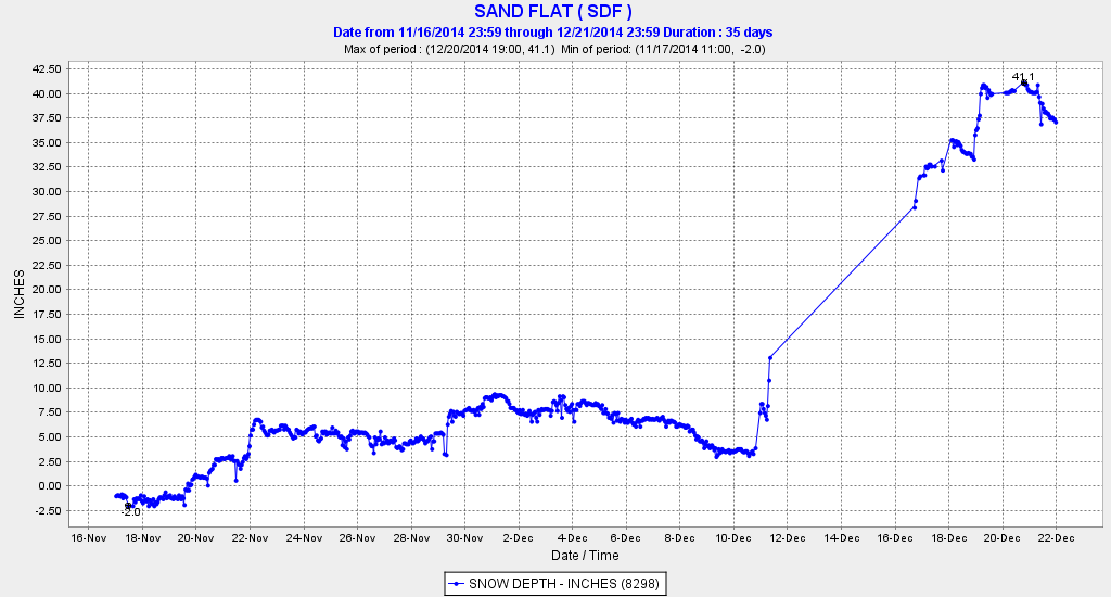
Lower down on the mountain, the snowpack has built up rapidly down to about 5500 ft during the most recent storms, after getting mostly rain during the huge December 10-12 system. The snowdepth reached 41" on December 21 at the CCSS telemetry site at Sand Flat at 6750 ft, and 25" at the base of the Mount Shasta Ski Park at 5500 ft. Here is the snowdepth at Sand Flat over the past month, unfortunately there was a data outage during the huge snowstorm, but thankfully the site came back online afterwards:
The Ski Park opened for the season on December 20, and things look much more hopeful than last year, during which the ski area only operated for about 3 days from December 26-28 and apparently never reopened the rest of the season. Although that was a truly nightmarish season by any standard, the nearby Mt Ashland Ski Area about 70 miles north up I-5 just over the Oregon border had an even worse year, never opening at all for the first time in its 50 year history. It's nice to see that this community-owned non-profit ski area managed to open for skiing on December 19 through the weekend, although snowpack remains marginal there and continued operation depends on additional snowfall.
The ongoing snowfall brought snowdepth at the 8250 ft Lassen Peak site up to 109" on December 20, which is within striking distance of the maximum depth reached last year. Although as mentioned above that site suffered a season-long data outage last year, the monthly snow course measurements showed 122" on April 2, 2014, which should have been fairly close to the seasonal maximum. Current snowdepth at the southwest entrance visitor center of Lassen Volcanic National Park (6700 ft) is about 60", with 14" at the very rain-shadowed Manzanita Lake (5800 ft) near the northwest entrance of the park and 6" at park headquarters in Mineral (5000 ft), several miles SW of the park itself.
And closer to home, although there's still a long way to go to reach normal depths, at least there's a real snowpack now at most measurement sites above 3000-4000 ft in the Washington Cascades and 5000-6000 ft in the Oregon Cascades, a sharp contrast to only a week ago when the bleak December 15 numbers came out. Mount Rainier Paradise reached 44" on December 20 (about 60% of normal for that date) and Mount Baker Ski Area reached 34" (still only 45% of normal, but vastly better than 6" last week). The SNOTEL data server has been offline all weekend, so there's been no way to check the snowpack at the Harts Pass SNOTEL site which had Washington's deepest snowpack a few days ago.
The deepest snowpack in Oregon is at Mount Bachelor, which reached 45" at its 6350 ft base and 73" at its 7300 ft mid-mountain snow stake on December 20 following 2 ft of recent snowfall. At Crater Lake National Park headquarters (6400 ft), snowdepth reached 40" on December 20 (78% of normal for the date) also after 2 ft of recent snowfall, with 50" at the Crater Lake Rim site (7050 ft).
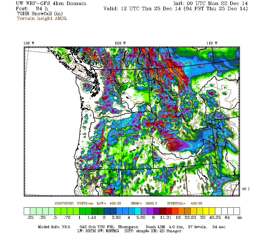
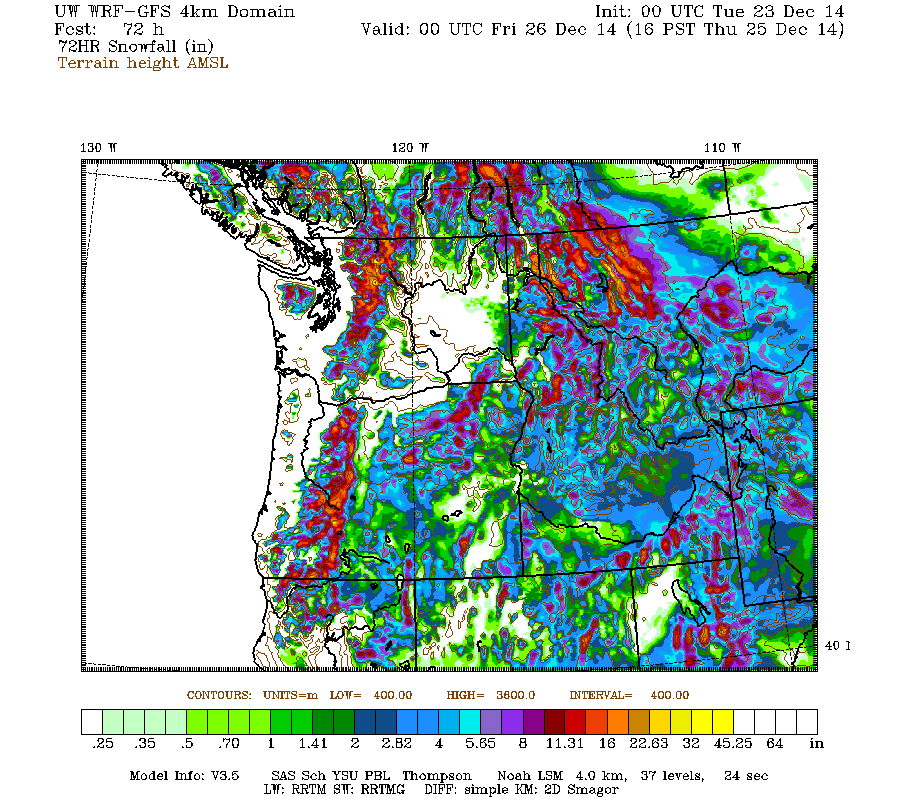
There has been some settlement during the rainy portion of the system Saturday overnight into Sunday, but renewed snowfall late Sunday is once again building snowdepths in the Washington and northern Oregon Cascades, and additional snowfall is expected on Tuesday-Wednesday. The current run of the high-resolution UW WRF-GFS model predicts moderate snowfall amounts of up to 1 ft over the entire length of the Cascade Range and into the northern Sierra Nevada during the 72-hour period through Thursday morning:
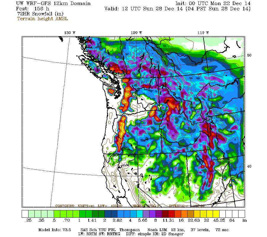
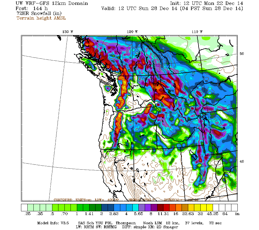
There's also the chance of a more potent snowstorm on Friday-Saturday, although models remain uncertain and confidence is not high yet. Snowfall amounts of up to 2-3 ft over the Washington and Oregon Cascades are predicted for the next 72-hour period through Sunday morning:
If that prediction actually pans out, then snowdepths will have recovered to near-normal values throughout most of the Cascade Range by the end of that storm.
Moderate snowfall continued in the California Cascades during the next 4 days after the original post above, producing an additional foot or so of new snow and one notable milestone on Mount Shasta. The snowdepth at Mount Shasta Old Ski Bowl at 7600 ft reached 83" on December 21, which easily surpasses the maximum depth reached at any point during last season's ongoing drought. The 2013-14 season's snowdepth topped out at only 77" on April 4, 2014, about 55% of the normal early April depth of almost 140" at this site over the 12 years since it was installed. Here are plots of snowdepth and precip over the past 30 days at Mount Shasta Old Ski Bowl, showing the huge December 10-12 storm and ongoing snowfall since then:
Almost 16" of precipitation in the last 3 weeks (actually about 2" more than that, since some precip was missed by the gauge in the middle of the huge snowstorm) should go a long way toward easing drought conditions. Down in Mount Shasta city at 3500 ft, there has been about 12.5" of precip thus far in December, about 250% of the normal of 5" by this time of the month.
Lower down on the mountain, the snowpack has built up rapidly down to about 5500 ft during the most recent storms, after getting mostly rain during the huge December 10-12 system. The snowdepth reached 41" on December 21 at the CCSS telemetry site at Sand Flat at 6750 ft, and 25" at the base of the Mount Shasta Ski Park at 5500 ft. Here is the snowdepth at Sand Flat over the past month, unfortunately there was a data outage during the huge snowstorm, but thankfully the site came back online afterwards:
The Ski Park opened for the season on December 20, and things look much more hopeful than last year, during which the ski area only operated for about 3 days from December 26-28 and apparently never reopened the rest of the season. Although that was a truly nightmarish season by any standard, the nearby Mt Ashland Ski Area about 70 miles north up I-5 just over the Oregon border had an even worse year, never opening at all for the first time in its 50 year history. It's nice to see that this community-owned non-profit ski area managed to open for skiing on December 19 through the weekend, although snowpack remains marginal there and continued operation depends on additional snowfall.
The ongoing snowfall brought snowdepth at the 8250 ft Lassen Peak site up to 109" on December 20, which is within striking distance of the maximum depth reached last year. Although as mentioned above that site suffered a season-long data outage last year, the monthly snow course measurements showed 122" on April 2, 2014, which should have been fairly close to the seasonal maximum. Current snowdepth at the southwest entrance visitor center of Lassen Volcanic National Park (6700 ft) is about 60", with 14" at the very rain-shadowed Manzanita Lake (5800 ft) near the northwest entrance of the park and 6" at park headquarters in Mineral (5000 ft), several miles SW of the park itself.
And closer to home, although there's still a long way to go to reach normal depths, at least there's a real snowpack now at most measurement sites above 3000-4000 ft in the Washington Cascades and 5000-6000 ft in the Oregon Cascades, a sharp contrast to only a week ago when the bleak December 15 numbers came out. Mount Rainier Paradise reached 44" on December 20 (about 60% of normal for that date) and Mount Baker Ski Area reached 34" (still only 45% of normal, but vastly better than 6" last week). The SNOTEL data server has been offline all weekend, so there's been no way to check the snowpack at the Harts Pass SNOTEL site which had Washington's deepest snowpack a few days ago.
The deepest snowpack in Oregon is at Mount Bachelor, which reached 45" at its 6350 ft base and 73" at its 7300 ft mid-mountain snow stake on December 20 following 2 ft of recent snowfall. At Crater Lake National Park headquarters (6400 ft), snowdepth reached 40" on December 20 (78% of normal for the date) also after 2 ft of recent snowfall, with 50" at the Crater Lake Rim site (7050 ft).
There has been some settlement during the rainy portion of the system Saturday overnight into Sunday, but renewed snowfall late Sunday is once again building snowdepths in the Washington and northern Oregon Cascades, and additional snowfall is expected on Tuesday-Wednesday. The current run of the high-resolution UW WRF-GFS model predicts moderate snowfall amounts of up to 1 ft over the entire length of the Cascade Range and into the northern Sierra Nevada during the 72-hour period through Thursday morning:
There's also the chance of a more potent snowstorm on Friday-Saturday, although models remain uncertain and confidence is not high yet. Snowfall amounts of up to 2-3 ft over the Washington and Oregon Cascades are predicted for the next 72-hour period through Sunday morning:
If that prediction actually pans out, then snowdepths will have recovered to near-normal values throughout most of the Cascade Range by the end of that storm.
Please Log in or Create an account to join the conversation.
- snoholic
- [snoholic]
-
- Offline
- Junior Member
-
Less
More
- Posts: 119
- Thank you received: 1
22 Dec 2014 06:31 #223302
by snoholic
Replied by snoholic on topic Re: Lassen Peak CA reaches 100" snowdepth!! 17Dec2014
Sounds promising, fingers crossed.
Please Log in or Create an account to join the conversation.
- Amar Andalkar
- [andalkar]
-
Topic Author
- Offline
- Premium Member
-
Less
More
- Posts: 635
- Thank you received: 0
22 Dec 2014 19:40 - 22 Dec 2014 21:31 #223311
by Amar Andalkar
Replied by Amar Andalkar on topic Re: Lassen Peak CA reaches 100" snowdepth!! 17Dec2014
The SNOTEL data server finally started working again on Monday afternoon, following an extended outage throughout the weekend, so some of the data missing from last night's post can now be found.
The greatest current snowdepth of any telemetry site in Washington or Oregon is still at the Harts Pass SNOTEL at 6500 ft, which reached 73" early on Monday December 22 after continued light snowfall overnight. In close 2nd place is the Lyman Lake SNOTEL at 5900 ft, which reached 70" around the same time. The Harts Pass site remains among the very few sites with above-normal snowpack with about 120% of normal SWE, while the Lyman Lake site is at about 85% of normal SWE (it is normally much snowier than Harts Pass).
The reasonably fat snowpack in the eastern North Cascades is not confined only to higher elevations either, as several sites at lower elevations have substantial snowpacks too. The Trinity SNOTEL at 2900 ft reached 41" early Sunday, roughly the same snowpack as Mount Rainier Paradise right now (!), and probably above-normal for this date -- but the Trinity SNOTEL was just installed in 2010, so normal values are not yet known. Holden Village at 3200 ft had 30" on Sunday (manual measurement), about 80% of normal for that date, while Mazama at 2200 ft reported 21" on the manual measurement (115% of normal) with the NWAC telemetry site briefly reaching 20".
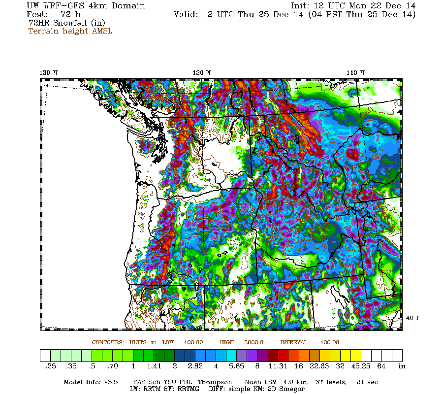
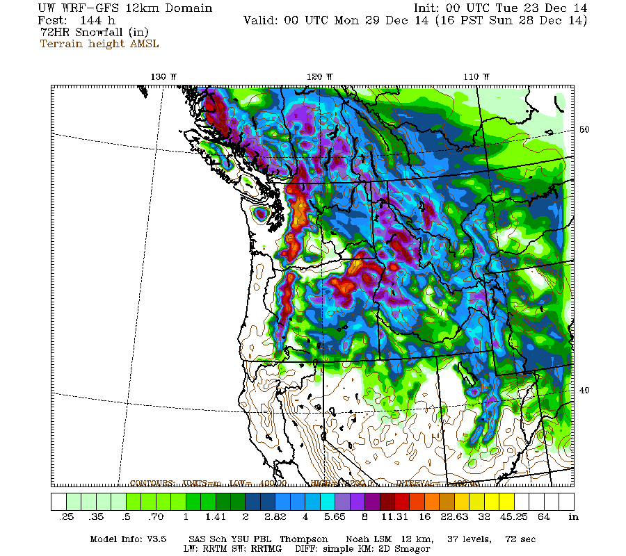
The upcoming weather forecast continues to look promising! This morning's run of the UW WRF-GFS model continued to predict heavy snowfall for the Cascades on Tuesday night into Wednesday (after some warm rain on Tuesday), and an even stronger system for Friday-Saturday, with much lower snow levels and no warm rain. Here are the same plots as the previous post, from this morning's model run, both looking very similar to yesterday:
Late evening update: The evening model run is still showing the same general story, with perhaps a bit more snow now predicted during the first system, and maybe a bit less during the second, especially in Oregon (note that these graphics are shifted forward by 12 hours from the previous 2 pairs above):
Overall, the consistency over the past 3 UW model runs since yesterday has been fairly good, although the NWS forecast discussion mentions other issues far out over the Pacific which are causing problems for the global weather models.
The greatest current snowdepth of any telemetry site in Washington or Oregon is still at the Harts Pass SNOTEL at 6500 ft, which reached 73" early on Monday December 22 after continued light snowfall overnight. In close 2nd place is the Lyman Lake SNOTEL at 5900 ft, which reached 70" around the same time. The Harts Pass site remains among the very few sites with above-normal snowpack with about 120% of normal SWE, while the Lyman Lake site is at about 85% of normal SWE (it is normally much snowier than Harts Pass).
The reasonably fat snowpack in the eastern North Cascades is not confined only to higher elevations either, as several sites at lower elevations have substantial snowpacks too. The Trinity SNOTEL at 2900 ft reached 41" early Sunday, roughly the same snowpack as Mount Rainier Paradise right now (!), and probably above-normal for this date -- but the Trinity SNOTEL was just installed in 2010, so normal values are not yet known. Holden Village at 3200 ft had 30" on Sunday (manual measurement), about 80% of normal for that date, while Mazama at 2200 ft reported 21" on the manual measurement (115% of normal) with the NWAC telemetry site briefly reaching 20".
The upcoming weather forecast continues to look promising! This morning's run of the UW WRF-GFS model continued to predict heavy snowfall for the Cascades on Tuesday night into Wednesday (after some warm rain on Tuesday), and an even stronger system for Friday-Saturday, with much lower snow levels and no warm rain. Here are the same plots as the previous post, from this morning's model run, both looking very similar to yesterday:
Late evening update: The evening model run is still showing the same general story, with perhaps a bit more snow now predicted during the first system, and maybe a bit less during the second, especially in Oregon (note that these graphics are shifted forward by 12 hours from the previous 2 pairs above):
Overall, the consistency over the past 3 UW model runs since yesterday has been fairly good, although the NWS forecast discussion mentions other issues far out over the Pacific which are causing problems for the global weather models.
Please Log in or Create an account to join the conversation.