SW Chutes - Adams, Jun 20
6/20/14
WA Cascades West Slopes South (Mt Rainier)
6396
9
The weekday and crap forecast kept people away. We were the only skiers down the chutes today, judging from (lack of) tracks.
Woke to drizzle, high winds, and clouds. Left Cold Springs at 6. Took 45 min break at Lunch Counter, huddled in wind break, waiting for snow to soften a bit.
Another party of two skiers bailed at this point. Pity, as the clouds lifted, the winds let up, and the sun was glorious up the headwall.
First thou or so of the chutes was FIRM. Some frozen chunky crap from recent snow. The rest was buttery corn. Some shenanigans on the traverse back (at 7000') towards Cold Springs trail.
So glad we stuck with it. It was an amazing day on a deserted mountain. It will be mobbed tomorrow (Sat).
Request or two for more info:
-About 3/4 mile hike before hitting snow.
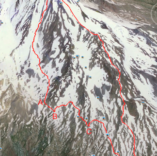
-Attached photo shows our descent. I've done this twice. I know some people drop lower and schwack back via RTM trail.
-Point A. As you exit the chutes, look left. About '10 o'clock'. You'll see a saddle with a snow tongue to the left of the saddle low point. Ski to that and then curve left around the ridge.
-You'll soon have one short carry. After that, traverse left, staying as high as possible. You'll quickly come to a very large drainage, and will be standing at point B. Look across the drainage to the other side and you'll see an obvious line of snow, just below the ridge, that you want to be on. To get there, put skins on and ascend 200 vertical feet as you contour around the bowl. At the high point, rip skins and continue to traverse left, staying high. We made it to point C with no other carries.
-From C, you'll be on the west edge of another large drainage and you'll see tons of boot tracks down below from people ascending the crescent glacier route. Don't get too close to the edge, it is super steep and would be a fast trip down. We carried skis uphill about 100' (not vertical feet) to a break in the steep snow wall that was easy to ski down. From there, it is a piece of cake getting out...
-About 3/4 mile hike before hitting snow.
-Attached photo shows our descent. I've done this twice. I know some people drop lower and schwack back via RTM trail.
-Point A. As you exit the chutes, look left. About '10 o'clock'. You'll see a saddle with a snow tongue to the left of the saddle low point. Ski to that and then curve left around the ridge.
-You'll soon have one short carry. After that, traverse left, staying as high as possible. You'll quickly come to a very large drainage, and will be standing at point B. Look across the drainage to the other side and you'll see an obvious line of snow, just below the ridge, that you want to be on. To get there, put skins on and ascend 200 vertical feet as you contour around the bowl. At the high point, rip skins and continue to traverse left, staying high. We made it to point C with no other carries.
-From C, you'll be on the west edge of another large drainage and you'll see tons of boot tracks down below from people ascending the crescent glacier route. Don't get too close to the edge, it is super steep and would be a fast trip down. We carried skis uphill about 100' (not vertical feet) to a break in the steep snow wall that was easy to ski down. From there, it is a piece of cake getting out...
Thanks very much for the info. I've not been to Adams before but really interested to summit and ski the SW chutes by splitboard. How much longer would you say it will be prime? Also, I've heard the road may require high clearance to drive, but I've got a pretty low riding passenger car - is that basically a no-go?
author=r1de link=topic=31949.msg134406#msg134406 date=1403368914]
Thanks very much for the info. I've not been to Adams before but really interested to summit and ski the SW chutes by splitboard. How much longer would you say it will be prime? Also, I've heard the road may require high clearance to drive, but I've got a pretty low riding passenger car - is that basically a no-go?
I would say 2 more weeks? The chutes themselves should stay good for some time, but the hike in / out will get longer and the lower bits on the way will turn into sun-cup crap.
We got to Cold Springs with the family minivan. So, if I can do that, you can probably manage it...Have fun. It is truly an awesome line.
Super, thanks for the beta!
(I'm looking forward to skiing the moguls on Monday after the weekend hordes...)
So in addition to the usual RMT exit, I've also previously returned by skinning up ~1400' vertical from ~7700' to arrive at the Lunch Counter.
(Freaks out overnighters who don't expect someone to show up on the other side of their camp...)
Almost no portages on that return, but the skinning is feasible only with perfect snow.
As a variation on your return, at Point B, how about just skinning up all the way to the NE until rejoining the initial ascent route? (Looking at BCN app map option for aerial overlaid with topo lines, looks a bit more moderate than "my" route, but hard to know for sure based on that.)
author=Jonathan_S. link=topic=31949.msg134418#msg134418 date=1403401729]
Super, thanks for the beta!
(I'm looking forward to skiing the moguls on Monday after the weekend hordes...)
So in addition to the usual RMT exit, I've also previously returned by skinning up ~1400' vertical from ~7700' to arrive at the Lunch Counter.
(Freaks out overnighters who don't expect someone to show up on the other side of their camp...)
Almost no portages on that return, but the skinning is feasible only with perfect snow.
As a variation on your return, at Point B, how about just skinning up all the way to the NE until rejoining the initial ascent route? (Looking at BCN app map option for aerial overlaid with topo lines, looks a bit more moderate than "my" route, but hard to know for sure based on that.)
Yeah, I don't know about that...From that bowl (just NE of 'B'), things looked pretty steep uphill. Looked like a super fun slope to ski, but I don't think you'd be able to skin up it. Bootpack, yes.
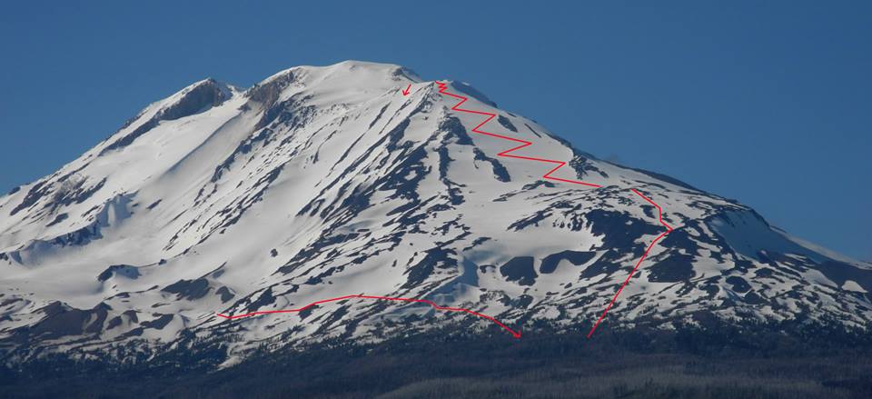
What a line. The view on 6/20 in the afternoon. Bluebird.
So the skinning is still continuous up the "winter" ascent route?
author=Jonathan_S. link=topic=31949.msg134434#msg134434 date=1403468715]
So the skinning is still continuous up the "winter" ascent route?
I booted a lot of it, my buddy skinned all the way to piker's. One or two very short carries.
author=Jonathan_S. link=topic=31949.msg134434#msg134434 date=1403468715]it was about a week ago, but only with much creativity and non-linear movement. At least one legit carry at "the dip" at about the elevation of the lower crescent glacier.
So the skinning is still continuous up the "winter" ascent route?
Reply to this TR
Please login first: