- Posts: 1087
- Thank you received: 0
HOW'D THAT HAPPEN??
- ron j
- [ron_j]
-
 Topic Author
- Offline
- Platinum Member
-

Less
More
09 Jul 2013 12:05 #121912
by ron j
HOW'D THAT HAPPEN?? was created by ron j
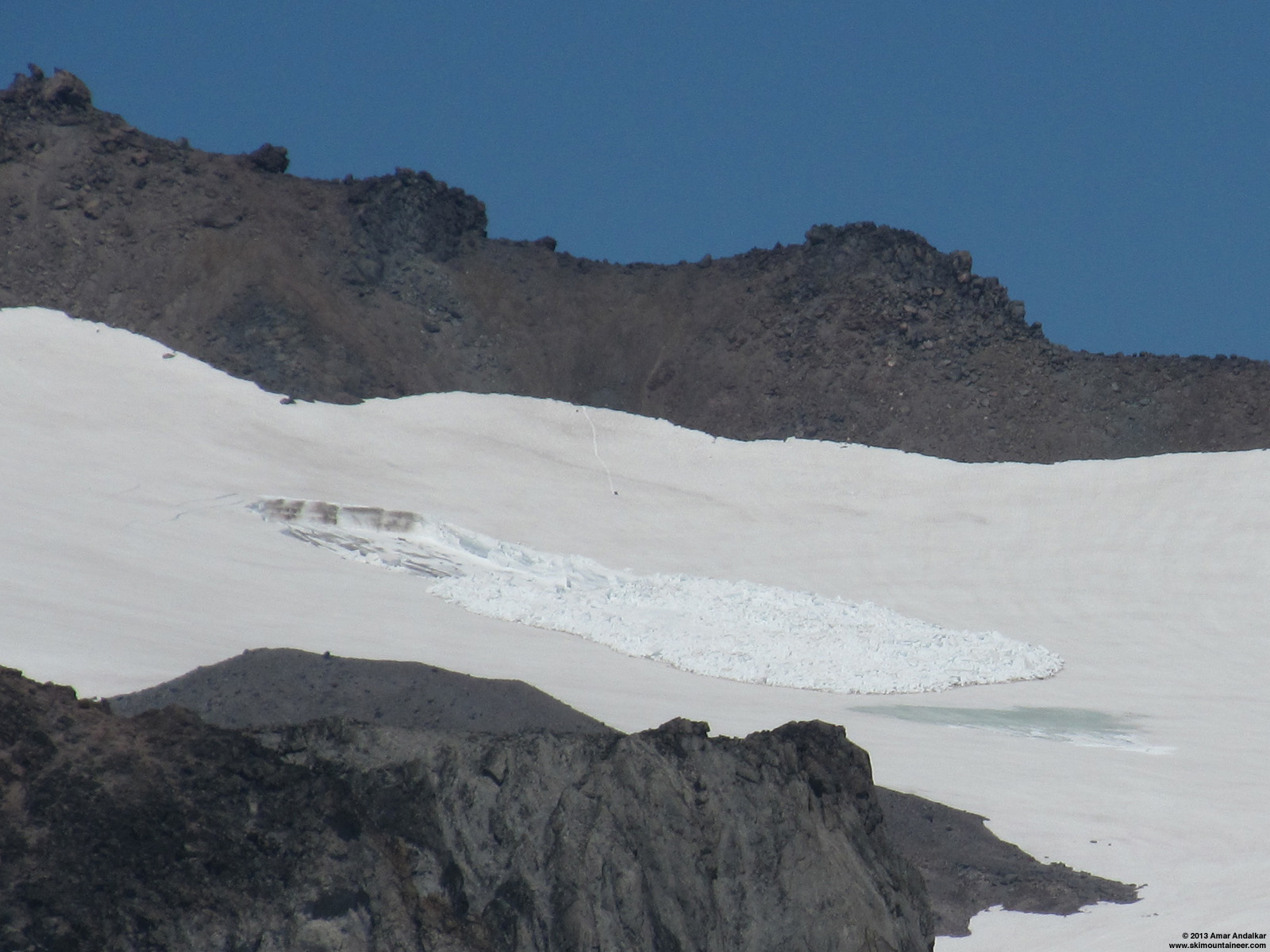
Ok all you would-be volcanologists and snow scientists, care to venture a guess as to the cause of this slide?

I saw this slide last Sunday while climbing on the west edge of the Paradise Glacier between about 7000 to 8000 ft, looking about level or slightly down ENE across to the WSW facing east side of the Cowlitz moraine in the general area where Amar and crew climbed up enroute to Little Tahoma recently.


My first thought was a blown out glide crack but it just didn’t look steep enough to blow out like that… I mean I know that slope angles can be deceiving from a distance, but still it just didn’t look more that about 25 degrees at that spot. And my guess the walls were at least 4 to 6 ft high.
Seems like it would take a lot of explosives to clean that hole out like that, eh? :")
Any theories?
I saw this slide last Sunday while climbing on the west edge of the Paradise Glacier between about 7000 to 8000 ft, looking about level or slightly down ENE across to the WSW facing east side of the Cowlitz moraine in the general area where Amar and crew climbed up enroute to Little Tahoma recently.
My first thought was a blown out glide crack but it just didn’t look steep enough to blow out like that… I mean I know that slope angles can be deceiving from a distance, but still it just didn’t look more that about 25 degrees at that spot. And my guess the walls were at least 4 to 6 ft high.
Seems like it would take a lot of explosives to clean that hole out like that, eh? :
Any theories?
Please Log in or Create an account to join the conversation.
- Robie
- [Robie]
-

- Offline
- Premium Member
-

Less
More
- Posts: 554
- Thank you received: 0
09 Jul 2013 22:24 #121928
by Robie
Replied by Robie on topic Re: HOW'D THAT HAPPEN??
Dave Thomas and I skied the paradise glacier on June 15. the slide was not there on that date .
We have a interest in the area because we have skied it so we are alway slooking that way for current access . It also doesn't show up in any of my pictures. Amar and friends visited that Area and climbed Little Tahoma with a report dated June 22. in his report there is a picture of of the area and no slide at that point. Those days of extra hot weather came after those dates I believe. Extra lubrication ?
We have a interest in the area because we have skied it so we are alway slooking that way for current access . It also doesn't show up in any of my pictures. Amar and friends visited that Area and climbed Little Tahoma with a report dated June 22. in his report there is a picture of of the area and no slide at that point. Those days of extra hot weather came after those dates I believe. Extra lubrication ?
Please Log in or Create an account to join the conversation.
- Gary Vogt
- [vogtski]
-
- Offline
- Premium Member
-
Less
More
- Posts: 511
- Thank you received: 8
10 Jul 2013 08:45 - 10 Jul 2013 08:49 #121933
by Gary Vogt
Replied by Gary Vogt on topic Re: HOW'D THAT HAPPEN??
Interesting, thanks for posting, Ron. I don't recall ever seeing dirt and rocks confined so strikingly to the base of avy debris. Possibly because it traveled such a short distance? It does suggest it was well lubricated.
These isolated slides on moderate slopes make me wonder if very localized hydrothermal vents might be involved. Wish I could afford the color infrared aerial photography; large scale images suggest spots of anomalous heat flow on some lower slopes of Rainier.
These isolated slides on moderate slopes make me wonder if very localized hydrothermal vents might be involved. Wish I could afford the color infrared aerial photography; large scale images suggest spots of anomalous heat flow on some lower slopes of Rainier.
Last edit: 10 Jul 2013 08:49 by Gary Vogt.
Please Log in or Create an account to join the conversation.
- RonL
- [RonL]
-
- Offline
- Senior Member
-

Less
More
- Posts: 259
- Thank you received: 0
10 Jul 2013 18:07 #121945
by RonL
Replied by RonL on topic Re: HOW'D THAT HAPPEN??
Bizarre, the dark surface of the crown is kind of striking. Perhaps that absorbed more heat than the rest of the surface
Please Log in or Create an account to join the conversation.
- gail
- [gail]
-
- Offline
- New Member
-

Less
More
- Posts: 5
- Thank you received: 0
10 Jul 2013 21:01 #121947
by gail
Replied by gail on topic Re: HOW'D THAT HAPPEN??
We saw that slide Friday, July 5th, from our perch on Paradise Glacier and were really puzzled by it, too! It looked so weird. Thanks for posting! Great pics.
Please Log in or Create an account to join the conversation.
- DonHeath
- []
-

- Visitor
-

11 Jul 2013 20:42 #121959
by DonHeath
Replied by DonHeath on topic Re: HOW'D THAT HAPPEN??
I think Silas wore that area out with too many laps! But I'd guess some kind of thermal vent in that area. Isn't there a face on Alpental that has some heating happen on a rock face, so it slides easy?
Please Log in or Create an account to join the conversation.
- Gary Vogt
- [vogtski]
-
- Offline
- Premium Member
-
Less
More
- Posts: 511
- Thank you received: 8
12 Jul 2013 09:38 #121961
by Gary Vogt
RonL's observation about the dark/dirty crown wall has caused me to rethink. Here's a simpler hypothesis that doesn't require random steam bursts.")
I've noticed many alpine meadows (esp. in the Olympics where there is lots of scree) that have miniature glacial 'eskers', sinuous gravel ridges 1-2 feet high and several hundred feet long, sometimes on top of the vegetation. I think these must be formed in melt tunnels at the base of the Spring snowpack during heavy rain or very warm weather. The avy location photos look pretty high on the slope for much runoff to form, but perhaps one of these subnivean drainages encountered a glide crack and filled it with a gravel slurry until the snowpack below broke loose?
Replied by Gary Vogt on topic Re: HOW'D THAT HAPPEN??
Bizarre, the dark surface of the crown is kind of striking...
RonL's observation about the dark/dirty crown wall has caused me to rethink. Here's a simpler hypothesis that doesn't require random steam bursts.
I've noticed many alpine meadows (esp. in the Olympics where there is lots of scree) that have miniature glacial 'eskers', sinuous gravel ridges 1-2 feet high and several hundred feet long, sometimes on top of the vegetation. I think these must be formed in melt tunnels at the base of the Spring snowpack during heavy rain or very warm weather. The avy location photos look pretty high on the slope for much runoff to form, but perhaps one of these subnivean drainages encountered a glide crack and filled it with a gravel slurry until the snowpack below broke loose?
Please Log in or Create an account to join the conversation.
- StormLady
- [StormLady]
-
- Offline
- New Member
-
Less
More
- Posts: 10
- Thank you received: 0
12 Jul 2013 15:55 #121965
by StormLady
Replied by StormLady on topic Re: HOW'D THAT HAPPEN??
Hmmmm, July 4, you say? I think a couple snowboarders with backpacks full of M-80s or fireworks, carefully placed could do that. And the perpetrators cleaned up the debris and carefully hid their tracks out of there - just to mess with park rangers' and TAYers' heads.
Please Log in or Create an account to join the conversation.
- davidG
- [davidG]
-
- Offline
- Elite Member
-

Less
More
- Posts: 764
- Thank you received: 0
12 Jul 2013 19:41 - 12 Jul 2013 20:25 #121967
by davidG
Replied by davidG on topic Re: HOW'D THAT HAPPEN??
well, .. those cracks have been there a while, eh? including the ones whose remnants are barely seen along the left edge of the slide, in the first magnified pic, and all in a decreasing radius from what would be the epicenter of the slumping snow, which gave way at one point as a wet slide due to localized subterranean heating, as evidenced by the small central and completely snow-free spot on the bed, pulling the snow from above, yet below the upper crack, with it as it moved a very short distance down slope, encountering firmer conditions and thereby jumping back onto the surface, leaving that hump at the top of the debris pile, and the rest sloughing according to fall line, moving the top couple of inches of snow - slush, really - along the perimeter, the same as a played-out wave will move the edge of seafoam inward on that wide, flat beach, demonstrating clearly the near liquid nature of a portion of that snowfield, set free by that single warm locus.
Last edit: 12 Jul 2013 20:25 by davidG.
Please Log in or Create an account to join the conversation.
- flowing alpy
- [flowing alpy]
-
- Offline
- Platinum Member
-
Less
More
- Posts: 1272
- Thank you received: 0
12 Jul 2013 20:58 #121968
by flowing alpy
b
Replied by flowing alpy on topic Re: HOW'D THAT HAPPEN??
just the type of spot silas would enjoy an adventure, esp. rockface, huh silas. ;DI think Silas wore that area out with too many laps! But I'd guess some kind of thermal vent in that area. Isn't there a face on Alpental that has some heating happen on a rock face, so it slides easy?
b
Please Log in or Create an account to join the conversation.
- ron j
- [ron_j]
-
Topic Author
- Offline
- Platinum Member
-
Less
More
- Posts: 1087
- Thank you received: 0
12 Jul 2013 21:30 - 12 Jul 2013 21:52 #121969
by ron j
Could have been...
Or it could just have been a real violent Storm... Lady . :
Replied by ron j on topic Re: HOW'D THAT HAPPEN??
Hmmmm, July 4, you say? I think a couple snowboarders with backpacks full of M-80s or fireworks, carefully placed could do that. And the perpetrators cleaned up the debris and carefully hid their tracks out of there - just to mess with park rangers' and TAYers' heads.
Could have been...
Or it could just have been a real violent Storm... Lady . :
Last edit: 12 Jul 2013 21:52 by ron j.
Please Log in or Create an account to join the conversation.
- BrianT
- [saxybrian]
-
- Offline
- Junior Member
-

Less
More
- Posts: 174
- Thank you received: 0
16 Jul 2013 13:24 #122015
by BrianT
Replied by BrianT on topic Re: HOW'D THAT HAPPEN??
Maybe a glide crack filled with some water and it was isolated to just that area under the glacier and eventually it had enough torque to slide it down? That slide scares me in some strange way as it looks like it would not do that at all.
Please Log in or Create an account to join the conversation.
- Lowell_Skoog
- [Lowell_Skoog]
-

- Offline
- Platinum Member
-
Less
More
- Posts: 1460
- Thank you received: 16
16 Jul 2013 21:13 #122022
by Lowell_Skoog
That's quite a sentence!
But it sounds plausible to me.
The thing that still has me puzzled is the very dark (sooty almost) crown wall at the top of the avalanche.
Were did that dirt come from? Did it collect on the crown wall after the slide released (from clouds of sooty steam perhaps)? Or did it collect before the slide released (perhaps as steam escaped through an initial glide crack)?
Why is the upper crown wall dirty, while the flanking walls are clean?
Replied by Lowell_Skoog on topic Re: HOW'D THAT HAPPEN??
well, .. those cracks have been there a while, eh? including the ones whose remnants are barely seen along the left edge of the slide, in the first magnified pic, and all in a decreasing radius from what would be the epicenter of the slumping snow, which gave way at one point as a wet slide due to localized subterranean heating, as evidenced by the small central and completely snow-free spot on the bed, pulling the snow from above, yet below the upper crack, with it as it moved a very short distance down slope, encountering firmer conditions and thereby jumping back onto the surface, leaving that hump at the top of the debris pile, and the rest sloughing according to fall line, moving the top couple of inches of snow - slush, really - along the perimeter, the same as a played-out wave will move the edge of seafoam inward on that wide, flat beach, demonstrating clearly the near liquid nature of a portion of that snowfield, set free by that single warm locus.
That's quite a sentence!
But it sounds plausible to me.
The thing that still has me puzzled is the very dark (sooty almost) crown wall at the top of the avalanche.
Were did that dirt come from? Did it collect on the crown wall after the slide released (from clouds of sooty steam perhaps)? Or did it collect before the slide released (perhaps as steam escaped through an initial glide crack)?
Why is the upper crown wall dirty, while the flanking walls are clean?
Please Log in or Create an account to join the conversation.
- T. Eastman
- [T. Eastman]
-
- Offline
- Senior Member
-
Less
More
- Posts: 288
- Thank you received: 0
17 Jul 2013 00:07 #122026
by T. Eastman
Replied by T. Eastman on topic Re: HOW'D THAT HAPPEN??
It was the work of Orcs!
Please Log in or Create an account to join the conversation.
- snoslut
- [boarddude]
-
- Offline
- Junior Member
-
Less
More
- Posts: 115
- Thank you received: 0
17 Jul 2013 13:46 #122038
by snoslut
Replied by snoslut on topic Re: HOW'D THAT HAPPEN??
Jarvis Jelly, that's how.
Please Log in or Create an account to join the conversation.
- TN
- [TN]
-
- Offline
- Junior Member
-
Less
More
- Posts: 50
- Thank you received: 0
17 Jul 2013 18:48 #122043
by TN
Replied by TN on topic Re: HOW'D THAT HAPPEN??
Seems to me that the guesses are right on, especially with that bare ground just above. Glide crack/dirty flow etc. That's a lot of weight to pop over the stauchwall, the snow below must be stuck pretty well. That spot should melt out quickly. Hopefully, someone will go right to it later and get pics. Looks like a rather smooth spot, is the rest of the area rougher?
Please Log in or Create an account to join the conversation.
- aaron_wright
- [aaron_wright]
-
- Offline
- Senior Member
-
Less
More
- Posts: 429
- Thank you received: 0
18 Jul 2013 09:32 #122050
by aaron_wright
Replied by aaron_wright on topic Re: HOW'D THAT HAPPEN??
The end is near, isn't that like a miniature lahar? Get ready Westsiders.
Please Log in or Create an account to join the conversation.
- Amar Andalkar
- [andalkar]
-
- Offline
- Premium Member
-
Less
More
- Posts: 635
- Thank you received: 0
18 Jul 2013 11:09 #122055
by Amar Andalkar
Replied by Amar Andalkar on topic Re: HOW'D THAT HAPPEN??
Interesting discussion and guesses here as to the cause of one of the most unusual avalanches I've ever seen. But the key point which seems to be missing in the posts above is that this avalanche occurred out in the middle of the Whitman Glacier! Therefore, the bed surface is entirely glacial ice, which must remain at a constant temperature of 0° C throughout the spring and summer. Thus there is no possibility of (direct) heating of the snowpack by steam vents or other geothermal sources. Meltwater from some source, flowing under the snow (perhaps temporarily pooling atop the glacial ice?) and lubricating the icy bed surface, is the most likely cause.
Some background info: I had skinned up and skied down just a few yards west of the location of this avalanche on June 22 on the way to Little Tahoma ( see TR ), and at that time there was no evidence of anything unusual at all on that part of the Whitman Glacier. The avalanche occurred sometime between the afternoon of Sunday, June 30 (when my photos from Paradise Glacier showed no evidence of it) and July 3, when I took the photos below:

[size=small]Telephoto view looking NE across from about 7400 ft on Paradise Glacier. (click for double-size version)[/size]
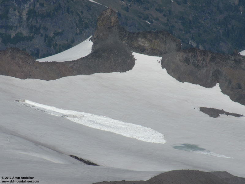
[size=small]Telephoto view looking due east and down from Muir Rock, Point 10188. (click for double-size version)[/size]
These photos clearly show an area where meltwater has reached the surface of the snowpack some distance below the terminus of the avalanche debris. For whatever reason, they also appear to show a much less dirty crown wall than Ron's photos. Note that Ron's photos above were taken on July 7 (right?), 4 days after these.
The period from June 30 to July 3 was the hottest of 2013 thus far in Washington, with a huge ridge of high pressure building from the desert Southwest towards the Pacific Northwest. Daily high temperatures at SeaTac Airport reached 93 °F on June 30 (the same day that Death Valley set an all-time June record high for the US of 129 °F), decreasing to 89 °F on July 1, 83 °F on July 2, and 79 °F on July 3. The freezing level at Mount Rainier was 14500 ft on June 30, increasing to 15500 ft on July 1 and 16000 ft on July 2, maxing out at 16500 ft overnight into July 3 (those are about the highest freezing levels which occur in most years on Rainier, only very rarely and barely does it exceed those values). Certainly that was ideal weather for generating a large amount of meltwater at 8000 ft on and within the Whitman Glacier.
I was shocked and intrigued when I first spotted this avalanche on July 3 looking across from Paradise Glacier, and knew that I needed to make a trip out there to visit the site as soon as possible. I finally did so last Sunday:
July 14, 2013, Mt Rainier, Fryingpan Glacier to Whitman Glacier: Investigating an Unusual Summertime Glacier Avalanche
(Full report with many panoramic photos of the avalanche and its blue-ice bed surface, along with measurements of its size.)
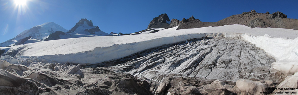
[size=small]Three-shot panorama from the southeast corner of the avalanche bed surface. (click for double-size version)[/size]
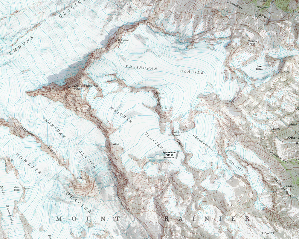
[size=small]Map of the avalanche site on Whitman Glacier. (click for double-size version)[/size]
[size=small](Topo + satellite overlay map from CalTopo )[/size]
Some background info: I had skinned up and skied down just a few yards west of the location of this avalanche on June 22 on the way to Little Tahoma ( see TR ), and at that time there was no evidence of anything unusual at all on that part of the Whitman Glacier. The avalanche occurred sometime between the afternoon of Sunday, June 30 (when my photos from Paradise Glacier showed no evidence of it) and July 3, when I took the photos below:
[size=small]Telephoto view looking NE across from about 7400 ft on Paradise Glacier. (click for double-size version)[/size]

[size=small]Telephoto view looking due east and down from Muir Rock, Point 10188. (click for double-size version)[/size]
These photos clearly show an area where meltwater has reached the surface of the snowpack some distance below the terminus of the avalanche debris. For whatever reason, they also appear to show a much less dirty crown wall than Ron's photos. Note that Ron's photos above were taken on July 7 (right?), 4 days after these.
The period from June 30 to July 3 was the hottest of 2013 thus far in Washington, with a huge ridge of high pressure building from the desert Southwest towards the Pacific Northwest. Daily high temperatures at SeaTac Airport reached 93 °F on June 30 (the same day that Death Valley set an all-time June record high for the US of 129 °F), decreasing to 89 °F on July 1, 83 °F on July 2, and 79 °F on July 3. The freezing level at Mount Rainier was 14500 ft on June 30, increasing to 15500 ft on July 1 and 16000 ft on July 2, maxing out at 16500 ft overnight into July 3 (those are about the highest freezing levels which occur in most years on Rainier, only very rarely and barely does it exceed those values). Certainly that was ideal weather for generating a large amount of meltwater at 8000 ft on and within the Whitman Glacier.
I was shocked and intrigued when I first spotted this avalanche on July 3 looking across from Paradise Glacier, and knew that I needed to make a trip out there to visit the site as soon as possible. I finally did so last Sunday:
July 14, 2013, Mt Rainier, Fryingpan Glacier to Whitman Glacier: Investigating an Unusual Summertime Glacier Avalanche
(Full report with many panoramic photos of the avalanche and its blue-ice bed surface, along with measurements of its size.)

[size=small]Three-shot panorama from the southeast corner of the avalanche bed surface. (click for double-size version)[/size]

[size=small]Map of the avalanche site on Whitman Glacier. (click for double-size version)[/size]
[size=small](Topo + satellite overlay map from CalTopo )[/size]
Please Log in or Create an account to join the conversation.
- JibberD
- [JibberD]
-
- Offline
- Senior Member
-
Less
More
- Posts: 267
- Thank you received: 0
19 Jul 2013 07:58 #122071
by JibberD
Replied by JibberD on topic Re: HOW'D THAT HAPPEN??
Wal-Mart folks at work, preparing the footing for a new suburban store? Seems like it's only a matter of time.
Please Log in or Create an account to join the conversation.
- garyabrill
- [garyabrill]
-
- Offline
- Senior Member
-
Less
More
- Posts: 464
- Thank you received: 0
09 Aug 2013 07:30 - 09 Aug 2013 07:38 #122321
by garyabrill
Replied by garyabrill on topic Re: HOW'D THAT HAPPEN??
Boy that is really amazing. There is a big difference between understanding how, in theory, this avalanche happened and the realities of the avalanche.
Imagine the incredible strength of the snowpack along the flanks, crown and stauchwall of the slab that had to be overcome before this slide could happen. It also clearly did not happen at a location of terrain stress concentration but rather on a uniform, moderate-angled slope, which makes it even more surprising.
I'll bet the NWAC folks would find this very interesting. I'll bet it would be a good coffee machine topic of conversation. Send them a copy. This email address is being protected from spambots. You need JavaScript enabled to view it. Include Amar's photo that shows meltwater concentration and the map.
There is likely nobody in the office now but they show up periodically in the summer and will be back in late summer to begin working on equipment, etc.
Last edit: 09 Aug 2013 07:38 by garyabrill.
Please Log in or Create an account to join the conversation.
- ron j
- [ron_j]
-
Topic Author
- Offline
- Platinum Member
-
Less
More
- Posts: 1087
- Thank you received: 0
09 Aug 2013 08:01 #122322
by ron j
Yes, quite noteworthy, Gary.
Looks like Garth already weighed in on the event on Amar's detailed inspection and embellishment of the event HERE .
Replied by ron j on topic Re: HOW'D THAT HAPPEN??
I'll bet the NWAC folks would find this very interesting. I'll bet it would be a good coffee machine topic of conversation. Send them a copy. This email address is being protected from spambots. You need JavaScript enabled to view it. Include Amar's photo that shows meltwater concentration and the map.
There is likely nobody in the office now but they show up periodically in the summer and will be back in late summer to begin working on equipment, etc.
Yes, quite noteworthy, Gary.
Looks like Garth already weighed in on the event on Amar's detailed inspection and embellishment of the event HERE .
Please Log in or Create an account to join the conversation.
- Gary Vogt
- [vogtski]
-
- Offline
- Premium Member
-
Less
More
- Posts: 511
- Thank you received: 8
18 Dec 2013 11:07 #125850
by Gary Vogt
Replied by Gary Vogt on topic Re: HOW'D THAT HAPPEN??
Very interesting program on sub-glacial streams at Mt Hood:
www.opb.org/television/programs/ofg/episodes/2501/
www.opb.org/television/programs/ofg/episodes/2501/
Please Log in or Create an account to join the conversation.