Mazama to Panorama Point 6/21/13
6/21/13
WA Cascades East Slopes North
2506
1
The good news: The road from Paradise to the Mazama Ridge parking area is now open. The bad news: They opened it after I hauled all my stuff down the road.
Heading up Mazama Ridge, snow was pretty bumpy and dirty but my skis stayed fairly clean on the trip down, perhaps because I've totally removed the wax. Above about 5500 feet, snow was much better, allowing a smooth trip down from the ridge. Typical spring firm-packed most of the way up, but starting at 6500 feet or so it got deeper and looser, probably from Thursday's snowfall. My trip down from 7000 feet was steep and soft enough that I released lots of rolling snowballs and was glad I brought my float pack (I'm old & super-cautious). Here's a link to my route (I turned on the GPS about 2/3 of the way up):
http://www.trimbleoutdoors.com/ViewTrip/2299988
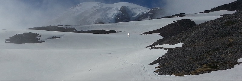
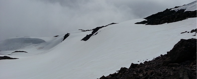
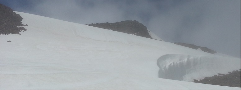
My plan was to reach the freeway of people skinning to Muir, but I turned around at 7000 because I wasn't sure of the safest route (see first picture below). The summer trail goes between the rocky areas, from right to left at the "?" symbol. There were some boot prints through the snow there that ended at the rocks. I'm wondering if anyone has skinned up or skied down just below the rocks to avoid the walk? I was tempted to follow that route (see the second picture), but was spooked by the lack of tracks since I was alone. See third picture for a third option that was skied down by some people much braver than I am, considering the 20-foot cliff above the rocks.
If anyone has traveled this route, please offer advice since I'd like to try it again in a week or so!
Heading up Mazama Ridge, snow was pretty bumpy and dirty but my skis stayed fairly clean on the trip down, perhaps because I've totally removed the wax. Above about 5500 feet, snow was much better, allowing a smooth trip down from the ridge. Typical spring firm-packed most of the way up, but starting at 6500 feet or so it got deeper and looser, probably from Thursday's snowfall. My trip down from 7000 feet was steep and soft enough that I released lots of rolling snowballs and was glad I brought my float pack (I'm old & super-cautious). Here's a link to my route (I turned on the GPS about 2/3 of the way up):
http://www.trimbleoutdoors.com/ViewTrip/2299988
My plan was to reach the freeway of people skinning to Muir, but I turned around at 7000 because I wasn't sure of the safest route (see first picture below). The summer trail goes between the rocky areas, from right to left at the "?" symbol. There were some boot prints through the snow there that ended at the rocks. I'm wondering if anyone has skinned up or skied down just below the rocks to avoid the walk? I was tempted to follow that route (see the second picture), but was spooked by the lack of tracks since I was alone. See third picture for a third option that was skied down by some people much braver than I am, considering the 20-foot cliff above the rocks.
If anyone has traveled this route, please offer advice since I'd like to try it again in a week or so!
Last time we skied it, a week ago, we could skin up to the right in the 1st picture (just barely enough snow and 1 short carry). We went all the way to McClure and skied down the roll and to skier's right around the blow hole in the 3rd pic. A common descent from Muir snowfield is around skier's right of McClure, then under the rock and down skier's left (similar to summer trail); but that varies a lot with snow conditions. This year a number of people have come down skier's left of McClure. To go above McClure, I would head up to the right of the rock, then go below it and continue around skier's left; there are other avenues as well; just depends on snow conditions, amount of rock exposed, and weather. But if you want to join the hoards, it is easier (faster, less climbing, more direct) just to follow them up from P'dise pkg lot.
btw, saw your tracks this a.m. on my way from 4th Xing to P'dise Glacier :-)
btw, saw your tracks this a.m. on my way from 4th Xing to P'dise Glacier :-)
Reply to this TR
Please login first: