June 15, 2013, Little Tahoma
6/15/13
WA Cascades West Slopes South (Mt Rainier)
53841
12
Summary: Jeff, Radka, and I completed a 15 1/2 hour day to the true summit of Little Tahoma that started at 3:30am and ended at 7pm with 14 miles and 7,500 feet of elevation. We had light winds most of the day although for the final 500' feet I did have 3 light layers on. Continuous snow exists from just after the bridge crossing below Summerland to the Whitman Crest Notch. From the other side, continuous snow all the way to the top of the Whitman Glacier. Snow conditions on the Upper Whitman Glacier were very bumpy with 8 inch crowns\flanks present and lots of recent debris. The 'shrund is open on climbers left about 1/8 - 1/4 of the way across the glacier. Snow conditions on the Frying Pan were overly soft at 4:30pm - 5pm descent time, but coverage is excellent and the steep shots down to Summerland were very enjoyable even at the late hour.
Detailed: This was a trip we wanted to do last year, but the "1 day assault" idea was still too new for Radka. :) Given this weekend's forecast and Radka's willingness to "go big", we knew Saturday was the day. We had attempted Little T once before, in 2009, where we turned around about 500' from the summit. The pain was still felt and we were determined to get it this year. We drove up Friday night and were falling asleep by 10pm. Alarms sounded at 2:30am and we were departing from the trailhead by 3:30am. Trailhead departure was temporarily delayed when I realized I didn't have my skins. Son of a...
The first 4 miles of the trail to the bridge crossing went quickly under headlamp and temperatures were perfect hiking weather. As the sun rose we caught glimpse of the alpenglow on Rainier through the trees. The last mile to the bridge was patchy snow that will probably melt out in the next week or 2.
After crossing the bridge, we continued on foot for another 5-10 minutes before realizing the snow would be continuous from here and it was time to transition to hard boots and skis. Or in my case, hard boots and crampons. It was now 6am and we started heading up Summerland towards Meany Crest vicinity under a firm crust that was mostly supportable for me. The clock was ticking for me now and I saw an existing bootpack leading to Meany Crest that I decided I had to stay on. Radka and Jeff went right towards ski friendly slopes and we lost sight of each other for about an hour. I learned later even their route required a small section of booting to gain the flat and mellow slopes on the Fryingpan Glacier. We soon spotted each other on the Fryingpan. It was interesting to note that we had taken the same amount of time to reach a near identical elevation.

![]() http://radkaandchris.smugmug.com/Skiing/20/Little-Tahoma-June-8/i-c3355Gr/0/XL/RAD_3097-Edit-XL.jpg" />
http://radkaandchris.smugmug.com/Skiing/20/Little-Tahoma-June-8/i-c3355Gr/0/XL/RAD_3097-Edit-XL.jpg" />
Soon there after, we rejoined on the Fryingpain at 8230'. It was now 8:45am and the snow was softening but still quite supportable for booting. However, Jeff and Radka volunteered to take 1 ski each from me since they were easily gliding across the surface, and I would punch through a few inches every 10-30 steps. Fortunately I had my toothpicks (Shuksans with Dynafits) so my burden on them was nearly unnoticeable. We only saw 1 open crevasse on the way to the Whitman Crest notch (easily avoided) and 1 sag along the traverse to the notch (easily avoidable with a lower elevation route to the notch).

Booting up to the notch of course sucked, with steep, shallow steps on a still icy snow surface. The wind was strongest here but we found a sheltered spot 10 feet or so above us where we took a break to eat and rest. Then we started onto the Whitman at 10:20am.

It was clear the Upper Whitman had recently shed. Large piles of avy debris were at the bottom and a long flank could be seen. The snow was pretty mushy here, being a direct south facing angle, and very bumpy, created from last week's snow fall and shedding. Jeff and Radka continued to skin but reported it was difficult. Eventually they transitioned to booting and headed over my way, on the left side of the glacier, which actually is just snow on top of talus. I had to laugh when I saw 3 skis on their packs.

I started putting up the bootpack for the final few hundred feet of the Whitman to the climber's left snow finger, passing some shallow glide cracks. In 2009, we came up this same way, but it was snow free and all loose sh!t (a technical term). At this point no one else ventured further up with their skis. Eventually Jeff and Radka bypassed me and took over, finishing the steps to a short rock step which leads to the final snow slope and scramble to the summit ridge. This rock step has running water too, as reported by the Mt Rainier BlogSpot. Of course the halo was going nuts at this point too!
![]() http://radkaandchris.smugmug.com/Skiing/20/Little-Tahoma-June-8/i-9bRkmHp/0/X2/RAD_3125-X2.jpg" />
http://radkaandchris.smugmug.com/Skiing/20/Little-Tahoma-June-8/i-9bRkmHp/0/X2/RAD_3125-X2.jpg" />
![]() http://radkaandchris.smugmug.com/Skiing/20/Little-Tahoma-June-8/i-WMt9Tz3/0/X2/RAD_3129-Edit-X2.jpg" />
http://radkaandchris.smugmug.com/Skiing/20/Little-Tahoma-June-8/i-WMt9Tz3/0/X2/RAD_3129-Edit-X2.jpg" />


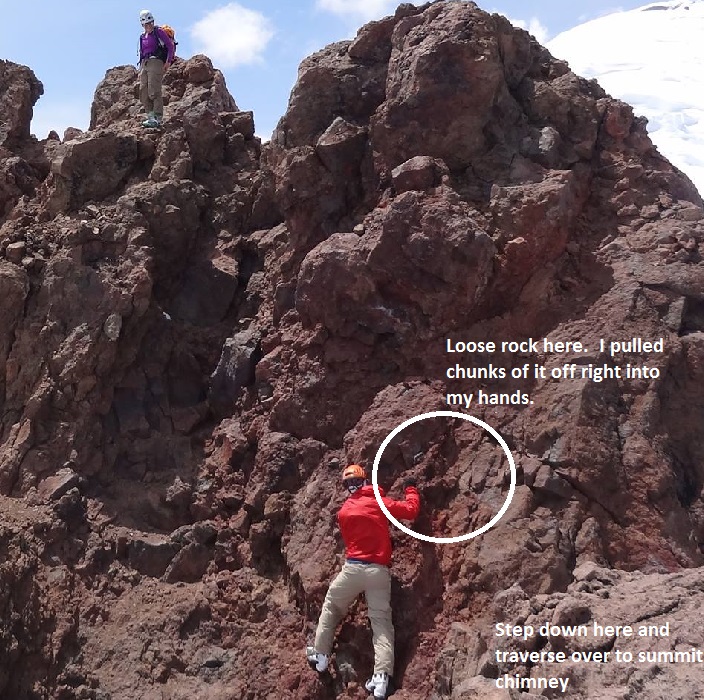
After the rock step, the summit ridge still seemed so far away. But eventually we made it. We knew the true summit had to be tagged or it would bother us. I was already vowing never to come back to the summit ridge. Little T is the most rotten PoS I have ever been on - worse than Formidable was last summer. The class 3 scramble to the true summit is not confidence inspiring when the handholds are portable! None-the-less we tagged it, and signed the register, happy to tick off another of the Top 10. Jeff having already been to the true summit, wisely decided he need not do it again.
![]() http://radkaandchris.smugmug.com/Skiing/20/Little-Tahoma-June-8/i-jhHv27f/1/XL/RAD_3145-Edit-XL.jpg" />
http://radkaandchris.smugmug.com/Skiing/20/Little-Tahoma-June-8/i-jhHv27f/1/XL/RAD_3145-Edit-XL.jpg" />
![]() http://radkaandchris.smugmug.com/Skiing/20/Little-Tahoma-June-8/i-t6JP5Nn/1/XL/RAD_3152-Edit-XL.jpg" />
http://radkaandchris.smugmug.com/Skiing/20/Little-Tahoma-June-8/i-t6JP5Nn/1/XL/RAD_3152-Edit-XL.jpg" />


We carefully descended back down to our skis. We ran into about 4 parties still heading up. The clouds were building and we wondered if the forecast t-storms might come early. Fortunately they did not and the weather stayed pleasant with partly cloudy skies. The skiing down the Upper Whitman was less than enjoyable, but it sure was nice to actually be on skis! Once on the Fryingpan it was also overly cooked corned.


The atmosphere was continuing to put on a display for us as we looked back over towards Rainier. The building clouds combined with the halo were absolutely remarkable!
![]() http://radkaandchris.smugmug.com/Skiing/20/Little-Tahoma-June-8/i-5bZhkmj/0/X2/RAD_3214-Edit-X2.jpg" />
http://radkaandchris.smugmug.com/Skiing/20/Little-Tahoma-June-8/i-5bZhkmj/0/X2/RAD_3214-Edit-X2.jpg" />
The steeps down to Summerland were much nicer than the Fryingpan proper, although we did send quite a bit of wet loose sluffs down. So we ski cut and cleared the slopes first before hitting them full on.


We quickly found our stashed shoes, glided our way to the bridge crossing, and transitioned back to carrying skis. The trail out was pleasant through beautiful forest that we didn't see in the morning. We made it back to car at 7pm, happy, satisfied, and sore. It looked like everyone forgot how to walk when we stopped in Enumclaw for dinner! Big thanks to Radka and Jeff for carrying my skis about 2200' feet! The one day assault proved to be quite the work out. It's amazing what can be accomplished in 1 day, compared with what could not be accomplished over 3 days in 2009.
Detailed: This was a trip we wanted to do last year, but the "1 day assault" idea was still too new for Radka. :) Given this weekend's forecast and Radka's willingness to "go big", we knew Saturday was the day. We had attempted Little T once before, in 2009, where we turned around about 500' from the summit. The pain was still felt and we were determined to get it this year. We drove up Friday night and were falling asleep by 10pm. Alarms sounded at 2:30am and we were departing from the trailhead by 3:30am. Trailhead departure was temporarily delayed when I realized I didn't have my skins. Son of a...
The first 4 miles of the trail to the bridge crossing went quickly under headlamp and temperatures were perfect hiking weather. As the sun rose we caught glimpse of the alpenglow on Rainier through the trees. The last mile to the bridge was patchy snow that will probably melt out in the next week or 2.
After crossing the bridge, we continued on foot for another 5-10 minutes before realizing the snow would be continuous from here and it was time to transition to hard boots and skis. Or in my case, hard boots and crampons. It was now 6am and we started heading up Summerland towards Meany Crest vicinity under a firm crust that was mostly supportable for me. The clock was ticking for me now and I saw an existing bootpack leading to Meany Crest that I decided I had to stay on. Radka and Jeff went right towards ski friendly slopes and we lost sight of each other for about an hour. I learned later even their route required a small section of booting to gain the flat and mellow slopes on the Fryingpan Glacier. We soon spotted each other on the Fryingpan. It was interesting to note that we had taken the same amount of time to reach a near identical elevation.
Soon there after, we rejoined on the Fryingpain at 8230'. It was now 8:45am and the snow was softening but still quite supportable for booting. However, Jeff and Radka volunteered to take 1 ski each from me since they were easily gliding across the surface, and I would punch through a few inches every 10-30 steps. Fortunately I had my toothpicks (Shuksans with Dynafits) so my burden on them was nearly unnoticeable. We only saw 1 open crevasse on the way to the Whitman Crest notch (easily avoided) and 1 sag along the traverse to the notch (easily avoidable with a lower elevation route to the notch).
Booting up to the notch of course sucked, with steep, shallow steps on a still icy snow surface. The wind was strongest here but we found a sheltered spot 10 feet or so above us where we took a break to eat and rest. Then we started onto the Whitman at 10:20am.
It was clear the Upper Whitman had recently shed. Large piles of avy debris were at the bottom and a long flank could be seen. The snow was pretty mushy here, being a direct south facing angle, and very bumpy, created from last week's snow fall and shedding. Jeff and Radka continued to skin but reported it was difficult. Eventually they transitioned to booting and headed over my way, on the left side of the glacier, which actually is just snow on top of talus. I had to laugh when I saw 3 skis on their packs.
I started putting up the bootpack for the final few hundred feet of the Whitman to the climber's left snow finger, passing some shallow glide cracks. In 2009, we came up this same way, but it was snow free and all loose sh!t (a technical term). At this point no one else ventured further up with their skis. Eventually Jeff and Radka bypassed me and took over, finishing the steps to a short rock step which leads to the final snow slope and scramble to the summit ridge. This rock step has running water too, as reported by the Mt Rainier BlogSpot. Of course the halo was going nuts at this point too!
After the rock step, the summit ridge still seemed so far away. But eventually we made it. We knew the true summit had to be tagged or it would bother us. I was already vowing never to come back to the summit ridge. Little T is the most rotten PoS I have ever been on - worse than Formidable was last summer. The class 3 scramble to the true summit is not confidence inspiring when the handholds are portable! None-the-less we tagged it, and signed the register, happy to tick off another of the Top 10. Jeff having already been to the true summit, wisely decided he need not do it again.
We carefully descended back down to our skis. We ran into about 4 parties still heading up. The clouds were building and we wondered if the forecast t-storms might come early. Fortunately they did not and the weather stayed pleasant with partly cloudy skies. The skiing down the Upper Whitman was less than enjoyable, but it sure was nice to actually be on skis! Once on the Fryingpan it was also overly cooked corned.
The atmosphere was continuing to put on a display for us as we looked back over towards Rainier. The building clouds combined with the halo were absolutely remarkable!
The steeps down to Summerland were much nicer than the Fryingpan proper, although we did send quite a bit of wet loose sluffs down. So we ski cut and cleared the slopes first before hitting them full on.
We quickly found our stashed shoes, glided our way to the bridge crossing, and transitioned back to carrying skis. The trail out was pleasant through beautiful forest that we didn't see in the morning. We made it back to car at 7pm, happy, satisfied, and sore. It looked like everyone forgot how to walk when we stopped in Enumclaw for dinner! Big thanks to Radka and Jeff for carrying my skis about 2200' feet! The one day assault proved to be quite the work out. It's amazing what can be accomplished in 1 day, compared with what could not be accomplished over 3 days in 2009.
Awesome report. Awesome photos. Makes me really want to go up there.
Sounds like a great trip. Glad I opted to Sahale, that was hard enough for me ;D
Very impressive work sansa skins. That summit scramble photo is awesome. To imagine doing that on such crappy rock is heart stopping.
Class 3 + rotten rock = Class 4
Class 4 + ski boots = Class 5
awesome photos
awesome day
thanks for the inspiration.
Class 4 + ski boots = Class 5
awesome photos
awesome day
thanks for the inspiration.
very nice report.
Very impressive Radka and Chris,
you guys Rock!
... you too, Jeff ;)
you guys Rock!
... you too, Jeff ;)
author=cchapin link=topic=28839.msg121289#msg121289 date=1371494525">
After the rock step, the summit ridge still seemed so far away. But eventually we made it. We knew the true summit had to be tagged or it would bother us. I was already vowing never to come back to the summit ridge. Little T is the most rotten PoS I have ever been on - worse than Formidable was last summer. The class 3 scramble to the true summit is not confidence inspiring when the handholds are portable! None-the-less we tagged it, and signed the register, happy to tick off another of the Top 10. Jeff having already been to the true summit, wisely decided he need not do it again.
Nice report, Chris, and awesome photos, Radka.
However, I'm curious as to where you're finding the loose rock on the final section of Little T. I had stayed away from Little T for years due to its reputation for loose rock (I really dislike scrambling on loose rock, and fear it for good reason). But since 2009, I've summited 3 times when the rock was dry (July 2009, June 2011, and July 2012), and stopped just a few vertical feet short of the true summit during this winter (February 2013) when the last bit of rock was too icy for my comfort level. In all 4 of those trips, I have yet to find any loose rock at all on the final scramble (the last loose rock was way down near 10800 ft exiting the top of Whitman Glacier, with mostly snow again from there up to 11100 ft). The rock has been quite solid, and no holds have budged at all, much less become portable.
So I have to think that the numerous parties that are finding loose rock must be ascending some different way up the last bit than I am. Are some parties attempting to go directly up the gully? That looks loose and nasty. The way that I've gone each time does not aim straight towards the summit, but instead goes up and right to the top of the east ridge near 11100 ft (the summit is 11138 ft). It then traverses west toward the summit on entirely solid rock, intersecting the final chimney to the summit only about 8-10 ft below the top, and the rock remains solid in this final short chimney. Based on your photos, it appears that you are taking the same route that I have.
I'm not trying to be critical of anyone at all, just trying to solve the mystery of where the loose rock is up there. Especially for the purposes of my Cascade volcanoes ski guidebook (Little T is included as a subsection of the Rainier chapter). As of now, I've been intending to state in the book (based on my own summit experiences) that the rock on the upper part of Little T is quite solid and not nearly as loose as reputed, if you follow the "right" route on the summit pinnacle. I would like to make sure that that information is correct. Thanks for any help that you (or anyone else) can provide on this issue.
Thanks all for your comments!
Great question Amar! Yes, this is the route that we took.
For this final bit, the loosest rock was on the traverse step from the ridge east of the summit over to the summit chimney. I was literally pulling it off in my hands for this step (wish Jeff had a picture of it in my hands). I was only using my hands for balance here - if the footholds had blown out I would have been in a pickle.
I agree the summit chimney is rather solid (compared to the rest of the mountain any way). I suspect climber traffic has put the chimney into this state. However, I would not trust any holds in that chimney blindly without testing them first (advice applicable for any scrambling or rock climbing). We did find some pieces in the chimney that would move with moderate force, but not peeling off with little effort. But we were able to find something more solid to choose from when encountering some looseness.
The ridge is also quite solid, but there are definitely some precariously perched boulders on it that need special attention when moving around, especially if there are parties below.
author=Amar Andalkar link=topic=28839.msg121312#msg121312 date=1371535961]
The way that I've gone each time does not aim straight towards the summit, but instead goes up and right to the top of the east ridge near 11100 ft (the summit is 11138 ft). It then traverses west toward the summit on entirely solid rock, intersecting the final chimney to the summit only about 8-10 ft below the top, and the rock remains solid in this final short chimney. Based on your photos, it appears that you are taking the same route that I have.
Great question Amar! Yes, this is the route that we took.
For this final bit, the loosest rock was on the traverse step from the ridge east of the summit over to the summit chimney. I was literally pulling it off in my hands for this step (wish Jeff had a picture of it in my hands). I was only using my hands for balance here - if the footholds had blown out I would have been in a pickle.
I agree the summit chimney is rather solid (compared to the rest of the mountain any way). I suspect climber traffic has put the chimney into this state. However, I would not trust any holds in that chimney blindly without testing them first (advice applicable for any scrambling or rock climbing). We did find some pieces in the chimney that would move with moderate force, but not peeling off with little effort. But we were able to find something more solid to choose from when encountering some looseness.
The ridge is also quite solid, but there are definitely some precariously perched boulders on it that need special attention when moving around, especially if there are parties below.
Thanks for the detailed answer and photo, that's useful info to know that rocks are loose at times in basically the same spots where everything has seemed solid on my trips.
On my future Little T summits, I'll make sure to retain the high degree of caution I had the first time up there, and not trust the rock blindly just because it has seemed to be solid on previous trips. Might as well retain the typical warnings of loose rock in the guidebook too.
On my future Little T summits, I'll make sure to retain the high degree of caution I had the first time up there, and not trust the rock blindly just because it has seemed to be solid on previous trips. Might as well retain the typical warnings of loose rock in the guidebook too.
author=Amar Andalkar link=topic=28839.msg121330#msg121330 date=1371583585]
Thanks for the detailed answer and photo, that's useful info to know that rocks are loose at times in basically the same spots where everything has seemed solid on my trips.
Could this perhaps be f(x) of temp?
Nice work, I was up there as a group of 4 on the 8th. We descended at 11 and the snow was already sloppy. A couple of big slides had already occurred from previous day and looked skier triggered and we triggered most of the rest of the slope, though they were manageable wet slides. I found the rock to be mostly solid, with a section or two of loose rock that got my attention. We camped below the bootpack, so did a few evening laps on the slopes below meany crest and those were by far the best turns of the weekend. Everything on the frying pan and above wasn't inspiring.
Now on the home page, thanks for the photo Radka! Great trip report.

Reply to this TR
Please login first: