Jan 13, the Sierra/ Tahoe
1/13/13
US elsewhere
2407
3
the b/c consists of the colder, lite wind storm of Christmas day. that was about 15 ", and there is about 6 - 8 " of the current light density storm from a few days ago. if you can find fresh, it is perfect. the local b/c is very tracked out so one needs to be creative, to access other spots. the unstable weaknesses from the rain crust/ sugar snow below, from early Dec. has subsided. base depths at the resorts are ranging from 10 - 15 ft (on the high side
I just checked Tahoe Daily and this morning it was -22 degrees, The seasonal snowfall is 60% and the forecast is a 2 week dry spell.
author=Zap link=topic=26979.msg113720#msg113720 date=1358117528]
I just checked Tahoe Daily and this morning it was -22 degrees, The seasonal snowfall is 60% and the forecast is a 2 week dry spell.
A) -22 degrees? are you working in celsius?
B) snowpack is well above 60%, http://www.tahoedailytribune.com/article/20130103/ARCHIVES01/130109982/1065/currentconditions&parentprofile=1065
author=komo link=topic=26979.msg113773#msg113773 date=1358184810">
A) -22 degrees? are you working in celsius?
B) snowpack is well above 60%, http://www.tahoedailytribune.com/article/20130103/ARCHIVES01/130109982/1065/currentconditions&parentprofile=1065
Zap was referring to The Tahoe Daily Snow (http://opensnow.com/dailysnow/tahoe, formerly at http://tahoeweatherdiscussion.com/), a very useful blog about upcoming and long-range weather conditions along the entire West Coast, with specific snowfall predictions for the Tahoe region.
See this post from Jan 13:
It was -22 degrees this morning at 6 a.m. at the Truckee Airport. That is unofficially a record low. We have a long way to go to warm up 45 degrees to the forecasted high of 23.
...
Luckily we have picked up 60% of the seasonal snowfall on the mountains less than 40% of the way through the season.
So apparently -22 Fahrenheit, not Celsius. And stating that roughly 60% of the average yearly snowfall (at Tahoe ski areas) has already fallen as of this date, not that snowpack is 60% of normal for this date.
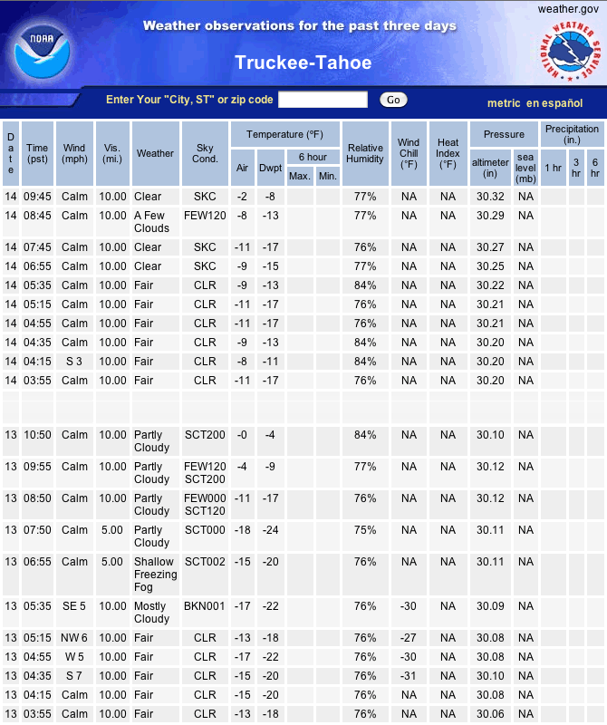
However, it looks like Bryan (The Tahoe Daily Snow author) misread the dew point for the air temperature at Truckee Tahoe Airport, so the actual temperature was "only" -17 °F with a dew point of -22 °F around 6am. The lowest temperature on Jan 13 occurred a couple hours later near 8am, reaching -18 °F with a dew point of -24 °F.
See National Weather Service, Observed Weather for past 3 Days, Truckee-Tahoe (http://w1.weather.gov/obhistory/KTRK.html), this screen grab shows the lowest temps yesterday and today -- it's still below zero °F this morning!:
I couldn't find historical records for the airport, but the records for the nearby Truckee Ranger Station (about 2 miles NW of the airport and at similar elevation, about 5900 ft) show record lows down to -28 °F for some days in January, so it can definitely get below -20 °F at Truckee.
From http://www.wrcc.dri.edu/cgi-bin/cliMAIN.pl?ca9043:
Daily Records for station 049043 TRUCKEE RANGER STN state: ca
For temperature and precipitation, multi-day accumulations
are not considered either for records or averages.
The year given is the year of latest occurrence.
Period requested -- Begin : 1/ 1/1850 -- End : 9/30/2012
Period used -- Begin : 9/ 1/1904 -- End : 12/18/2011
Cooling degree threshold = 65.00 Heating degree threshold = 65.00
AVG Multi-year unsmoothed average of the indicated quantity
HI Highest value of indicated quantity for this day of year
LO Lowest value of indicated quantity for this day of year
YR Latest year of occurrence of the extreme value
NO Number of years with data for this day of year.
Units: English (inches and degrees F)
|---Maximum Temperature---|---Minimum Temperature---|----Precipitation---|-------Snowfall-----|------Snowdepth-----|--Heat--|--Cool--
MO DY AVG NO HI YR LO YR AVG NO HI YR LO YR AVG NO HIGH YR AVG NO HIGH YR AVG NO HIGH YR HDD NO CDD NO
1 1 38 88 58 1918 18 1952 13 87 40 1997 -15 1919 0.137 87 2.01 1997 0.98 86 12.0 2005 17.1 68 70. 1952 39.8 87 0.0 87
1 2 37 86 60 1918 12 1952 13 86 40 1997 -14 1919 0.188 86 3.42 1997 1.22 86 16.0 2004 16.8 69 69. 1952 40.1 86 0.0 86
1 3 37 88 62 1915 8 1910 11 88 31 1914 -14 1919 0.169 85 4.50 1916 1.41 86 45.0 1916 17.2 68 69. 1952 40.9 88 0.0 88
1 4 38 88 55 2003 15 1910 13 88 33 2007 -17 1949 0.127 85 1.26 1987 1.23 85 21.0 1987 17.4 66 68. 1952 39.7 88 0.0 88
1 5 38 88 60 1911 12 1913 13 88 31 1986 -12 1972 0.209 86 3.95 2008 1.74 86 27.0 1982 18.2 66 58. 1982 39.8 88 0.0 88
1 6 37 89 56 2001 14 1913 13 89 40 1918 -9 1949 0.158 85 2.28 1959 1.54 85 21.0 1959 18.9 67 55. 1993 40.1 89 0.0 89
1 7 39 89 59 1969 10 1937 14 89 41 1918 -21 1937 0.147 86 2.15 1965 1.34 85 22.0 1965 18.8 66 60. 1993 38.9 89 0.0 89
1 8 40 88 58 2009 8 1937 14 88 34 1990 -26 1937 0.155 86 2.34 2005 1.39 85 16.0 2005 18.3 69 64. 1993 38.0 88 0.0 88
1 9 40 88 55 1983 22 1913 15 89 37 1911 -22 1937 0.188 86 2.05 1940 1.86 85 24.0 1911 18.6 69 65. 1993 37.9 88 0.0 88
1 10 41 89 58 1941 10 1913 16 90 33 1959 -9 1949 0.208 86 2.70 1916 1.56 86 27.0 1916 18.8 70 70. 1993 37.0 89 0.0 89
1 11 40 88 59 1986 8 1913 16 89 33 2000 -12 1909 0.184 86 1.63 1950 1.75 85 30.0 1950 19.2 70 70. 1993 37.3 88 0.0 88
1 12 39 88 58 1990 12 1910 15 88 34 1959 -15 1963 0.216 87 2.39 1980 2.07 85 30.0 1911 20.2 70 86. 1952 38.3 88 0.0 88
1 13 39 90 60 1996 15 1963 15 90 33 1980 -12 1917 0.214 87 1.90 1980 2.00 85 24.0 1911 20.0 70 86. 1952 38.5 90 0.0 90
1 14 40 90 57 1996 13 1997 17 90 38 1909 -15 1917 0.237 86 1.43 1980 1.97 86 18.0 1950 20.8 69 86. 1952 37.1 90 0.0 90
1 15 40 89 56 1996 15 1917 16 89 40 1909 -20 1917 0.216 86 1.97 1970 1.55 86 14.0 1979 21.9 83 118. 1911 37.4 89 0.0 89
1 16 39 89 55 1967 10 1917 16 89 42 1974 -21 1917 0.204 86 1.56 2000 1.53 85 16.0 1952 21.3 69 108. 1952 37.7 89 0.0 89
1 17 38 90 55 1959 8 1917 15 90 38 1909 -28 1917 0.339 87 3.60 1914 2.32 86 36.0 1914 21.8 71 100. 1952 38.5 90 0.0 90
1 18 40 89 58 1961 12 1910 15 89 40 1909 -22 1917 0.154 87 2.80 1914 1.41 86 28.0 1914 21.9 69 98. 1952 37.9 89 0.0 89
1 19 41 90 58 1986 14 1910 14 90 40 1909 -26 1913 0.185 86 1.94 1951 1.58 85 28.0 1951 22.4 68 95. 1952 37.7 90 0.0 90
1 20 39 90 58 1986 10 1913 14 90 36 1909 -25 1937 0.169 88 2.00 1969 1.56 85 17.0 1957 21.8 69 90. 1952 38.7 90 0.0 90
1 21 40 90 64 1950 8 1937 14 90 36 1950 -28 1937 0.261 88 3.22 1943 1.48 85 17.0 1964 22.8 69 100. 1952 38.6 90 0.0 90
1 22 39 90 57 1963 12 1962 15 90 39 1970 -18 1917 0.228 88 2.86 1967 1.80 85 28.0 1967 23.1 70 96. 1952 38.1 90 0.0 90
1 23 40 89 57 1981 17 1962 15 89 41 1910 -20 1962 0.187 86 2.88 1997 1.10 86 22.0 1997 22.5 68 90. 1952 37.6 89 0.0 89
1 24 40 90 55 1992 18 1909 15 90 39 1911 -20 1962 0.258 88 2.39 1910 2.01 86 24.0 1910 24.1 71 90. 1952 37.6 90 0.0 90
1 25 40 89 60 2007 15 1949 16 89 32 2000 -19 1949 0.275 88 2.80 1914 2.04 85 28.0 1914 24.5 68 86. 1952 37.2 89 0.0 89
1 26 40 89 57 2007 14 1913 17 89 38 1912 -6 1917 0.205 87 2.63 1969 1.44 86 15.0 1914 24.6 68 82. 1952 36.7 89 0.0 89
1 27 40 90 58 2003 14 1913 16 90 33 1967 -10 1957 0.252 87 2.39 1916 2.24 86 31.0 1937 25.2 70 80. 1952 37.5 90 0.0 90
1 28 39 90 56 1988 8 1913 14 90 33 1920 -8 1979 0.176 86 1.65 1981 1.95 86 18.0 1981 25.7 68 78. 1952 38.4 90 0.0 90
1 29 40 90 59 1976 15 1910 13 90 40 1911 -13 1979 0.080 87 2.16 1967 0.96 85 17.0 1981 25.1 68 78. 1952 38.7 90 0.0 90
1 30 40 89 60 1920 10 1910 13 89 34 1986 -16 1916 0.194 87 3.99 2011 1.56 86 20.0 1968 25.5 69 78. 1952 38.7 89 0.0 89
1 31 40 89 60 1920 18 1913 14 89 35 1995 -18 1917 0.153 85 2.61 1963 1.27 86 16.0 1939 25.8 81 84. 1916 38.6 89 0.0 89
[/tt">[/size">
Reply to this TR
Please login first: