- Posts: 1212
- Thank you received: 3
Weather Forecast - Exciting
- Zap
- [Zap]
-
 Topic Author
- Offline
- Platinum Member
-

Less
More
19 Oct 2012 09:08 - 21 Oct 2012 11:47 #206649
by Zap
Weather Forecast - Exciting was created by Zap
The Cliff Mass Weather Blog, on October 20, is looking great from BC thru the Cascades and the Sierras.
cliffmass.blogspot.com/
cliffmass.blogspot.com/
Please Log in or Create an account to join the conversation.
- J.P.
- [J.P.]
-
- Offline
- Junior Member
-

Less
More
- Posts: 94
- Thank you received: 0
19 Oct 2012 14:59 #206656
by J.P.
Replied by J.P. on topic Re: Weather Forecast - Exciting
Especially with 1-hr snowfall model predictions like Saturday at 2 a.m. and 11 a.m....:
www.atmos.washington.edu/~ovens/wxloop.c...m5d2_wa_snow1+//84/1
www.atmos.washington.edu/~ovens/wxloop.c...m5d2_wa_snow1+//84/1
Please Log in or Create an account to join the conversation.
- Amar Andalkar
- [andalkar]
-
- Offline
- Premium Member
-

Less
More
- Posts: 635
- Thank you received: 0
19 Oct 2012 16:29 #206658
by Amar Andalkar
Very interesting, but . . . those are obvious glitches -- 1-2 ft snowfalls in a single hour!?!? Somehow, many-hour totals were being displayed on the 1-hour graphics for those 2 times. I've never seen that particular glitch before in the UW model graphics.
Anyway, it seems to have fixed itself now -- the correct graphics are now in that loop, and show nothing special about the values for Saturday at 2 a.m. and 11 a.m. anymore. I did not save the erroneous graphics for those hours to my computer, before they were fixed.
However, the 24-hour graphics are still messed up because of the glitch, as seen below. It's going to snow heavily this weekend, but it will certainly not snow 2-4 ft in 24 hours over the entire WA Cascades as shown in this ERRONEOUS graphic:
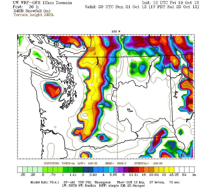
One can easily check the 4km model run for the same times, to see that this particular glitch is isolated to the 12 km run. However, even the 4km is screwed up in a different way. The large area of snowfall shown in the lowlands of Puget Sound is definitely NOT going to happen either:
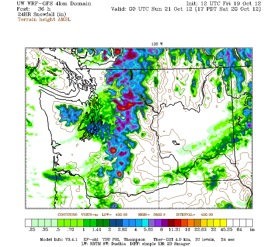
I have no idea why the model is acting so strangely today. They had disk-related problems last night and this morning, but that seems to be an unlikely cause of these glitches.
Replied by Amar Andalkar on topic Re: Weather Forecast - Exciting
Especially with 1-hr snowfall model predictions like Saturday at 2 a.m. and 11 a.m....:
www.atmos.washington.edu/~ovens/wxloop.c...m5d2_wa_snow1+//84/1
Very interesting, but . . . those are obvious glitches -- 1-2 ft snowfalls in a single hour!?!? Somehow, many-hour totals were being displayed on the 1-hour graphics for those 2 times. I've never seen that particular glitch before in the UW model graphics.
Anyway, it seems to have fixed itself now -- the correct graphics are now in that loop, and show nothing special about the values for Saturday at 2 a.m. and 11 a.m. anymore. I did not save the erroneous graphics for those hours to my computer, before they were fixed.
However, the 24-hour graphics are still messed up because of the glitch, as seen below. It's going to snow heavily this weekend, but it will certainly not snow 2-4 ft in 24 hours over the entire WA Cascades as shown in this ERRONEOUS graphic:
One can easily check the 4km model run for the same times, to see that this particular glitch is isolated to the 12 km run. However, even the 4km is screwed up in a different way. The large area of snowfall shown in the lowlands of Puget Sound is definitely NOT going to happen either:
I have no idea why the model is acting so strangely today. They had disk-related problems last night and this morning, but that seems to be an unlikely cause of these glitches.
Please Log in or Create an account to join the conversation.
- garyabrill
- [garyabrill]
-
- Offline
- Senior Member
-

Less
More
- Posts: 464
- Thank you received: 0
19 Oct 2012 17:25 #206659
by garyabrill
Replied by garyabrill on topic Re: Weather Forecast - Exciting
I'd say get it while you can. The new long term CPC forecasts show our precip around normal in November with still slightly cooler than normal temperatures. Since this is a transition period, though, I'd bet details are up in the air. That said there are definite signs that a high amplitude ridge is trying to build once again into the dateline, progressively so towards the end of the month.
Please Log in or Create an account to join the conversation.
- andybrnr
- [andybrnr]
-
- Offline
- New Member
-

Less
More
- Posts: 25
- Thank you received: 0
20 Oct 2012 00:35 #206662
by andybrnr
Replied by andybrnr on topic Re: Weather Forecast - Exciting
Hey guys,
I called that snapshot out on our department WX list this morning trying to figure out what was going on. There have been some issues in the last few days with the system doing the post-processing, and a few of the post-processed files (though not the actual forecast) got screwed up. I clarified a few points on the 12km and 4km snow output today with Cliff, and thought I'd share them here.
So as those of you who poke around the forecast model output may have noticed, there are two fields for snow: "model-snow" and "snow." Model snow is the precip that the WRF model categorizes as snow, namely precip at or above the model freezing level. In the real world, precip continues to fall as snow as much as 1000ft below the freezing level, as it takes some time for the flakes to melt in the warmer air, and depending on the ground temp accumulations can still occur. To try and account for this, the output precip fields are post processed, and precip up to 1000ft below the freezing level is recategorized as snow, scaled by some empirical liquid water to snow accumulation factor, and added on to the amount the model considers snow. This will catch lowland snow that might hit the hilltops in the metro area when the temperatures are borderline and the model prematurely melts precip.
The error in those couple of outputs was the result of the freezing level field being corrupted at a few specific times by some failure that is still being diagnosed. The corrupted files put the freezing level right at the surface throughout the domain, meaning that all precip was considered snow, even though freezing levels will in reality be around 4000-3500ft. The "snow" field was then recomputed assuming the freezing level at sea level, resulting in spuriously high snow accumulations at a few specific times. Note that the "model-snow" field never displayed a glitch, as the actual forecast and output was not corrupted-- this only occurred in the additional post-processing to create the "snow" field. Sadly, this event will not be putting three feet across the crest in a three hours stretch... pity that, really.
In short, if you want a conservative estimate of snowfall, use the "model-snow" fields. Glancing at the difference between "model-snow" and "snow" can help show where some marginal accumulations might occur and potentially play havoc with a commute, but for skiing purposes, "model-snow" is probably safer.
Please Log in or Create an account to join the conversation.
- hyak.net
- [hyak.net]
-
- Offline
- Premium Member
-
Less
More
- Posts: 601
- Thank you received: 0
20 Oct 2012 08:20 #206664
by hyak.net
Replied by hyak.net on topic Re: Weather Forecast - Exciting
It is currently snowing at Hyak and the ground is white. It just started around 8am but we should have 1/2" pretty soon.
Please Log in or Create an account to join the conversation.
- BrianT
- [saxybrian]
-
- Offline
- Junior Member
-
Less
More
- Posts: 174
- Thank you received: 0
20 Oct 2012 20:48 #206666
by BrianT
Replied by BrianT on topic Re: Weather Forecast - Exciting
Went to hyak, 4 inches in ground towards Cathrine, another 3 the hour we were there. Still snowing hard when I left. I suspect over a foot tonight or more. plan on trying summit west tomorrow for a few easy Oct laps
Please Log in or Create an account to join the conversation.
- Amar Andalkar
- [andalkar]
-
- Offline
- Premium Member
-
Less
More
- Posts: 635
- Thank you received: 0
21 Oct 2012 12:40 #206672
by Amar Andalkar
Thanks for the info about the problems, and also the explanation of model-snow versus snow. I had been wondering what the exact difference was since the model-snow graphics started being included last year.
Replied by Amar Andalkar on topic Re: Weather Forecast - Exciting
I called that snapshot out on our department WX list this morning trying to figure out what was going on. There have been some issues in the last few days with the system doing the post-processing, and a few of the post-processed files (though not the actual forecast) got screwed up. I clarified a few points on the 12km and 4km snow output today with Cliff, and thought I'd share them here.
So as those of you who poke around the forecast model output may have noticed, there are two fields for snow: "model-snow" and "snow." Model snow is the precip that the WRF model categorizes as snow, namely precip at or above the model freezing level. In the real world, precip continues to fall as snow as much as 1000ft below the freezing level, as it takes some time for the flakes to melt in the warmer air, and depending on the ground temp accumulations can still occur. To try and account for this, the output precip fields are post processed, and precip up to 1000ft below the freezing level is recategorized as snow, scaled by some empirical liquid water to snow accumulation factor, and added on to the amount the model considers snow. This will catch lowland snow that might hit the hilltops in the metro area when the temperatures are borderline and the model prematurely melts precip.
The error in those couple of outputs was the result of the freezing level field being corrupted at a few specific times by some failure that is still being diagnosed. The corrupted files put the freezing level right at the surface throughout the domain, meaning that all precip was considered snow, even though freezing levels will in reality be around 4000-3500ft. The "snow" field was then recomputed assuming the freezing level at sea level, resulting in spuriously high snow accumulations at a few specific times. Note that the "model-snow" field never displayed a glitch, as the actual forecast and output was not corrupted-- this only occurred in the additional post-processing to create the "snow" field. Sadly, this event will not be putting three feet across the crest in a three hours stretch... pity that, really.
In short, if you want a conservative estimate of snowfall, use the "model-snow" fields. Glancing at the difference between "model-snow" and "snow" can help show where some marginal accumulations might occur and potentially play havoc with a commute, but for skiing purposes, "model-snow" is probably safer.
Thanks for the info about the problems, and also the explanation of model-snow versus snow. I had been wondering what the exact difference was since the model-snow graphics started being included last year.
Please Log in or Create an account to join the conversation.
- garyabrill
- [garyabrill]
-
- Offline
- Senior Member
-
Less
More
- Posts: 464
- Thank you received: 0
22 Oct 2012 09:59 #206688
by garyabrill
Replied by garyabrill on topic Re: Weather Forecast - Exciting
Yeah,
One look at that 12km model indicated it was an outlier.
Interesting synopsis of the models, andy.
One look at that 12km model indicated it was an outlier.
Interesting synopsis of the models, andy.
Please Log in or Create an account to join the conversation.