- Posts: 5
- Thank you received: 0
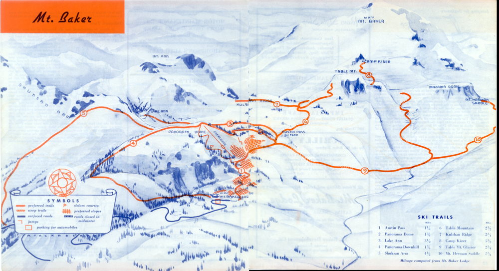
Good Baker BC Map
- Eckels
- [Eckels]
-
 Topic Author
- Offline
- New Member
-

Less
More
04 Oct 2012 19:56 #206461
by Eckels
Good Baker BC Map was created by Eckels
I'm currently turning one wall/slanted celing in my room into a collection of map and picture references of the baker area. Map wise I have both sides of the North Cascades National Geographic up and a few pictures, but I would love to find a big shaded topo map of the 542 corridor, preferably with minimal legal lines/boundries cluttering things. I also want an even more detailed map of the Terrain within a day of Heather Meadows.
Does anybody know of any good maps already in circulation (I'd prefer not to piece quads together) or where I can order a custom map for cheapish?
I'll post pics of the wall when its complete.
Does anybody know of any good maps already in circulation (I'd prefer not to piece quads together) or where I can order a custom map for cheapish?
I'll post pics of the wall when its complete.
Please Log in or Create an account to join the conversation.
- hyak.net
- [hyak.net]
-
- Offline
- Premium Member
-

Less
More
- Posts: 601
- Thank you received: 0
04 Oct 2012 21:44 #206466
by hyak.net
Replied by hyak.net on topic Re: Good Baker BC Map
I have this one. It is old, but shows the old ski lines from 1936.
Please Log in or Create an account to join the conversation.
- Jim Oker
- [jim_oker]
-
- Offline
- Elite Member
-

Less
More
- Posts: 900
- Thank you received: 0
04 Oct 2012 22:03 #206467
by Jim Oker
Replied by Jim Oker on topic Re: Good Baker BC Map
Please Log in or Create an account to join the conversation.
- samthaman
- [samthaman]
-
- Offline
- Junior Member
-

Less
More
- Posts: 158
- Thank you received: 0
04 Oct 2012 22:37 #206468
by samthaman
I had a 15 quad USGS panorama of mt baker and shuksan on the wall of my apt in Bellingham, if you ask me, it looked pretty cool. I just folded the corners under and put them edge to edge, it takes up a ton of space though. 3 quads tall is pretty much ceiling to knee height and 5 wide is about 6-7 feet wide if memory serves me.
Replied by samthaman on topic Re: Good Baker BC Map
I'm currently turning one wall/slanted celing in my room into a collection of map and picture references of the baker area. Map wise I have both sides of the North Cascades National Geographic up and a few pictures, but I would love to find a big shaded topo map of the 542 corridor, preferably with minimal legal lines/boundries cluttering things. I also want an even more detailed map of the Terrain within a day of Heather Meadows.
Does anybody know of any good maps already in circulation (I'd prefer not to piece quads together) or where I can order a custom map for cheapish?
I'll post pics of the wall when its complete.
I had a 15 quad USGS panorama of mt baker and shuksan on the wall of my apt in Bellingham, if you ask me, it looked pretty cool. I just folded the corners under and put them edge to edge, it takes up a ton of space though. 3 quads tall is pretty much ceiling to knee height and 5 wide is about 6-7 feet wide if memory serves me.
Please Log in or Create an account to join the conversation.
- Scole
- [Scole]
-
- Offline
- Junior Member
-
Less
More
- Posts: 124
- Thank you received: 0
13 Oct 2012 17:00 #206563
by Scole
Replied by Scole on topic Re: Good Baker BC Map
Wow- thanks Hyak for that share! I've never found a name for that peak located SW of Lake Ann (labeled at Mount Ann on your scan). Given its size and prominence, I found it surprising that it didn't have a name.
Steve
Steve
Please Log in or Create an account to join the conversation.
- Lowell_Skoog
- [Lowell_Skoog]
-

- Offline
- Platinum Member
-

Less
More
- Posts: 1460
- Thank you received: 16
14 Oct 2012 08:04 #206567
by Lowell_Skoog
Notice the line marked "Escalator" in the map that Jack posted.
This was the first ski lift of any kind installed in Washington. Here's a picture of it from "Ski-ing" by Charles Proctor, which I borrowed from Rolf Borgersen of Winthrop. Rolf's uncle Orville Borgersen took the picture in 1935-36.

Here's a brief note about the lift from Ramon Heller's excellent book "Mount Baker Ski Area":
alpenglow.org/ski-history/notes/book/hel...html#heller-1980-p38
Replied by Lowell_Skoog on topic Re: Good Baker BC Map
I have this one. It is old, but shows the old ski lines from 1936.
Notice the line marked "Escalator" in the map that Jack posted.
This was the first ski lift of any kind installed in Washington. Here's a picture of it from "Ski-ing" by Charles Proctor, which I borrowed from Rolf Borgersen of Winthrop. Rolf's uncle Orville Borgersen took the picture in 1935-36.
Here's a brief note about the lift from Ramon Heller's excellent book "Mount Baker Ski Area":
alpenglow.org/ski-history/notes/book/hel...html#heller-1980-p38
p. 38: In May 1935 the Pacific Northwest Ski Association held its first slalom tournament at Panorama Dome. In December 1935 the Mt Baker Development Company began operating a cable-drawn sled called a "ski escalator" that carried skiers from Terminal Lake up Panorama Dome. Early in 1936, after the sled had been in operation less than a month, Arthur Brandlund, the developer of the lift, was killed in an avalanche that came off Panorama Dome.
Please Log in or Create an account to join the conversation.
- samthaman
- [samthaman]
-
- Offline
- Junior Member
-
Less
More
- Posts: 158
- Thank you received: 0
14 Oct 2012 08:55 #206568
by samthaman
there is a fun little chute out there on mt anne.
Replied by samthaman on topic Re: Good Baker BC Map
Wow- thanks Hyak for that share! I've never found a name for that peak located SW of Lake Ann (labeled at Mount Ann on your scan). Given its size and prominence, I found it surprising that it didn't have a name.
Steve
there is a fun little chute out there on mt anne.
Please Log in or Create an account to join the conversation.
- -Josh-
- [bakerguy87]
-
- Offline
- New Member
-
Less
More
- Posts: 14
- Thank you received: 0
14 Oct 2012 20:03 #206575
by -Josh-
Replied by -Josh- on topic Re: Good Baker BC Map
lake Ann butte I believe its called, saw some really nice ski lines on it last year from shuksun arm.
Please Log in or Create an account to join the conversation.
- -Josh-
- [bakerguy87]
-
- Offline
- New Member
-
Less
More
- Posts: 14
- Thank you received: 0
14 Oct 2012 20:07 #206576
by -Josh-
Replied by -Josh- on topic Re: Good Baker BC Map
Lake Ann butte I believe its called, saw some really nice ski tracks on it last year from shuksan arm
Please Log in or Create an account to join the conversation.
- samthaman
- [samthaman]
-
- Offline
- Junior Member
-
Less
More
- Posts: 158
- Thank you received: 0
14 Oct 2012 20:56 #206578
by samthaman
I believe its on the USGS quad as mount anne, but I could be wrong
Replied by samthaman on topic Re: Good Baker BC Map
Lake Ann butte I believe its called, saw some really nice ski tracks on it last year from shuksan arm
I believe its on the USGS quad as mount anne, but I could be wrong
Please Log in or Create an account to join the conversation.
- hyak.net
- [hyak.net]
-
- Offline
- Premium Member
-
Less
More
- Posts: 601
- Thank you received: 0
15 Oct 2012 09:34 #206583
by hyak.net
Thanks Lowell for posting that photo! Looks like the ski escalator may have been the inspiration for the Talley Ho Ski Boggan installed 10 years later at the Milwaukee ski bowl.
Replied by hyak.net on topic Re: Good Baker BC Map
Notice the line marked "Escalator" in the map that Jack posted.
This was the first ski lift of any kind installed in Washington. Here's a picture of it from "Ski-ing" by Charles Proctor, which I borrowed from Rolf Borgersen of Winthrop. Rolf's uncle Orville Borgersen took the picture in 1935-36.
Here's a brief note about the lift from Ramon Heller's excellent book "Mount Baker Ski Area":
Thanks Lowell for posting that photo! Looks like the ski escalator may have been the inspiration for the Talley Ho Ski Boggan installed 10 years later at the Milwaukee ski bowl.
Please Log in or Create an account to join the conversation.
- Scole
- [Scole]
-
- Offline
- Junior Member
-
Less
More
- Posts: 124
- Thank you received: 0
15 Oct 2012 20:12 #206595
by Scole
Nope, it's not:
USGS 1:24,000 Topo
1915 USGS 1:125,000 scale map
Replied by Scole on topic Re: Good Baker BC Map
I believe its on the USGS quad as mount anne, but I could be wrong
Nope, it's not:
USGS 1:24,000 Topo
1915 USGS 1:125,000 scale map
Please Log in or Create an account to join the conversation.
- samthaman
- [samthaman]
-
- Offline
- Junior Member
-
Less
More
- Posts: 158
- Thank you received: 0
16 Oct 2012 07:40 #206601
by samthaman
further demonstration of how unreliable memory is, I had those maps on my wall for over a year and looked at them at least once a day.
Replied by samthaman on topic Re: Good Baker BC Map
Nope, it's not:
USGS 1:24,000 Topo
1915 USGS 1:125,000 scale map
further demonstration of how unreliable memory is, I had those maps on my wall for over a year and looked at them at least once a day.
Please Log in or Create an account to join the conversation.