July 30 and 31, 2012, Adams SW Chutes and NW Passage
7/15/12
WA Cascades West Slopes South (Mt Rainier)
2850
0
The full three-"day" TR is posted at your pick of peanut galleries:
http://timefortuckerman.com/forums/showthread.php?t=15040
http://www.tetongravity.com/forums/showthread.php/247263-TR-July-30-amp-31-Adams-Aug-1-Hood
But here I just wanted to highlight what I think is a great return route from the SW Chutes at current snowpack levels.
Previously, after ~4,400' of cumulative skiing (from the summit), the default option for us has been to ski another ~1,000 to the use trail to the Round-the-Mountain trail, which is a long flat hike (or skin) back to Cold Springs, i.e., all effort in return for no additional skiing. (Or earlier in the season, the return to Morrison Creek is very easy -- we finally got to experience that in late June this year, although from a nice snowfield to the west of the Crescent Glacier, since we had turned around just shy of the South Climb topout on account of increasingly crazy weather on that day that lenticular clouds simultaneously descended on both Adams & Rainier. Detailed accounts from back then can be read here or here since I neglected to post a TAY TR at the time.)
But I had decided to experiment this year with an alternative route. I had reviewed old archived files on my computer, read many trip reports from this summer, studied the topo maps carefully, and plotted out on a course on my GPS.
So after all that research and analysis I just winged it when I looked up and saw a route that looked good, and which seemed to match up with a route I had noticed earlier from the ascent.
And the result was that . . . I ended up ascending a different gully than the one I had noticed earlier on the ascent (as that gully appears to be discontinuous at the base), but Im convinced the route I took is the Northwest Passage (figuratively, as its literally a NE passage) for the return from the SW Chutes:
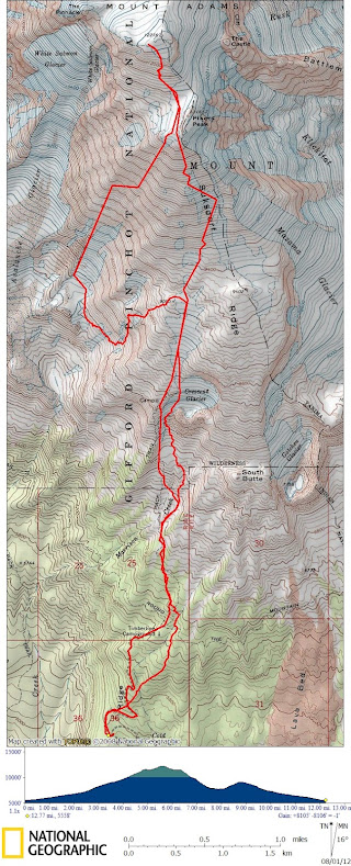
As should be obvious from the suspiciously straight segments, I didnt have the track log on the entire time, so this map is a mix of averaged segments from previous trips, plus actual track logs where I deviated significantly from prior routes.
In more detail for those potentially interested in this route:
At ~7,750 I traversed to skiers left, then skinned ~1,010' up a steep gully, followed by ~340' of low- and moderate-angle hiking up some well-behaved rocks.
This brought me to one of the flat campsites at the top of the Lunch Counter flats (or whatever theyre called) at ~9,100. (Alternatively, would be very easy to veer a bit further right than I did near the top, contouring instead of climbing, for savings of about ~150' of so of additional ascent.)
Maybe this is still more total effort than the RMT return, but this way I was able to get in much more skiing (which was especially nice in the steepest part of the Crescent Not-Really-A-Glacier), for another ~2,860' (i.e., past the South Climb junction w/ the RMT, with some creative ribbon connecting plus a few short portages) with a final ~530' downhike.
I was so happy with this route on Monday (i.e., Cold Springs > Summit > SW Chutes > NW Passage > Cold Springs) that I simply repeated exactly the same route on Tuesday. Should be good for awhile longer too!
http://timefortuckerman.com/forums/showthread.php?t=15040
http://www.tetongravity.com/forums/showthread.php/247263-TR-July-30-amp-31-Adams-Aug-1-Hood
But here I just wanted to highlight what I think is a great return route from the SW Chutes at current snowpack levels.
Previously, after ~4,400' of cumulative skiing (from the summit), the default option for us has been to ski another ~1,000 to the use trail to the Round-the-Mountain trail, which is a long flat hike (or skin) back to Cold Springs, i.e., all effort in return for no additional skiing. (Or earlier in the season, the return to Morrison Creek is very easy -- we finally got to experience that in late June this year, although from a nice snowfield to the west of the Crescent Glacier, since we had turned around just shy of the South Climb topout on account of increasingly crazy weather on that day that lenticular clouds simultaneously descended on both Adams & Rainier. Detailed accounts from back then can be read here or here since I neglected to post a TAY TR at the time.)
But I had decided to experiment this year with an alternative route. I had reviewed old archived files on my computer, read many trip reports from this summer, studied the topo maps carefully, and plotted out on a course on my GPS.
So after all that research and analysis I just winged it when I looked up and saw a route that looked good, and which seemed to match up with a route I had noticed earlier from the ascent.
And the result was that . . . I ended up ascending a different gully than the one I had noticed earlier on the ascent (as that gully appears to be discontinuous at the base), but Im convinced the route I took is the Northwest Passage (figuratively, as its literally a NE passage) for the return from the SW Chutes:
As should be obvious from the suspiciously straight segments, I didnt have the track log on the entire time, so this map is a mix of averaged segments from previous trips, plus actual track logs where I deviated significantly from prior routes.
In more detail for those potentially interested in this route:
At ~7,750 I traversed to skiers left, then skinned ~1,010' up a steep gully, followed by ~340' of low- and moderate-angle hiking up some well-behaved rocks.
This brought me to one of the flat campsites at the top of the Lunch Counter flats (or whatever theyre called) at ~9,100. (Alternatively, would be very easy to veer a bit further right than I did near the top, contouring instead of climbing, for savings of about ~150' of so of additional ascent.)
Maybe this is still more total effort than the RMT return, but this way I was able to get in much more skiing (which was especially nice in the steepest part of the Crescent Not-Really-A-Glacier), for another ~2,860' (i.e., past the South Climb junction w/ the RMT, with some creative ribbon connecting plus a few short portages) with a final ~530' downhike.
I was so happy with this route on Monday (i.e., Cold Springs > Summit > SW Chutes > NW Passage > Cold Springs) that I simply repeated exactly the same route on Tuesday. Should be good for awhile longer too!
Reply to this TR
Please login first: