June 9-10, 2012, Mt. Baker, Coleman Deming
6/9/12
WA Cascades West Slopes North (Mt Baker)
4216
6
Headed up to climb the coleman deming this weekend. Lots of fun and some beautiful views, despite turning 1600 feet from the summit.
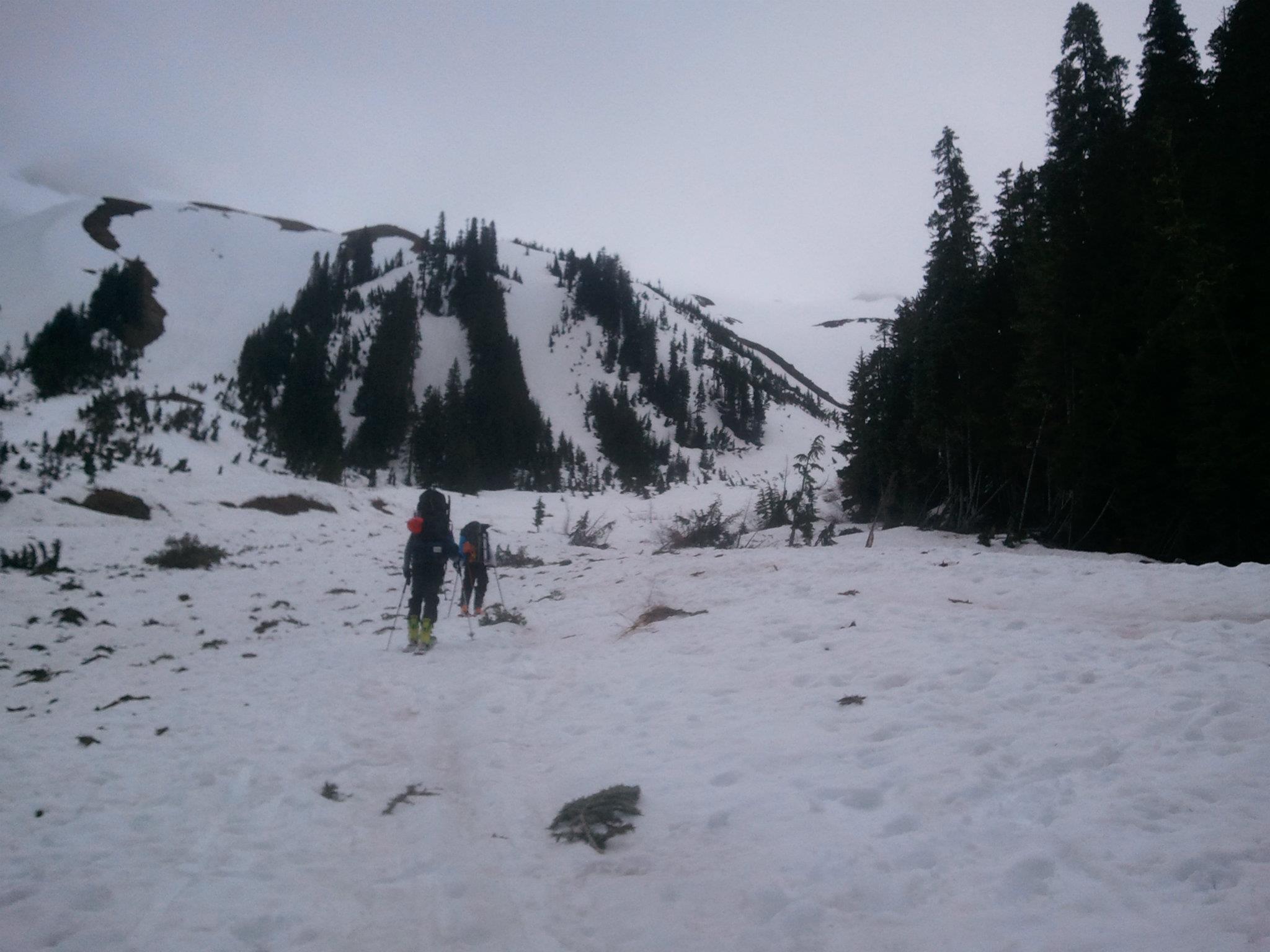
Three of us set out on saturday morning, taking the standard heliotrope ridge trail from the TH. Before long, we realized it wasn't going to link up with the winter route (the one that starts behind the outhouse) so we bushwhacked to change course. 3 tricky creek crossings later and we were finally on snow, having gained only a few hundred feet in 1.5 hrs. Good times.
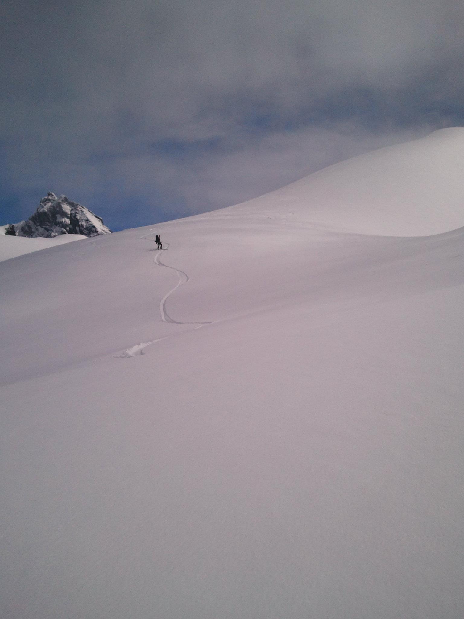
Continued on upward, hanging a left at the Y in the valley to start moving more eastward and eventually link up with the main climbers route. Around 6000 feet we ascended into the clouds, dropping visibility quickly. We ascended the steep head of the gully to where it meets the open and mellower slopes above, finding ourselves in 40 ft visibility once we reached the top.
At this point we had a mile or two of traversing to get over to Black Buttes camp. Not knowing the terrain very well and unable to see anything in the clouds and flat light, we roped up, plotted a bearing and set off. A few hours later we arrived near what we thought was our destination, but finding the actual camp was like finding a needle in a haystack, despite the GPS. Finding a flat spot on the glacier, we made camp around 8.
Left camp at 4am, again navigating by compass and gps to cross the coleman glacier. Ran into a party of 4 from Bellingham who turned shortly thereafter - no shame there, visibility was poor and the crevasses massive. Several hours and a long crevassed dead-end turnaround later, we popped out of the clouds into beautiful sunshine around 8000 feet. Fyi for those wondering, our route took us on a 96 degree bearing from the flats just below the black buttes. This turned out to be a bit lower than ideal for crevasse navigation right now - the better route would be to take the same bearing from right up against the buttes until reaching the turn below the coleman saddle.
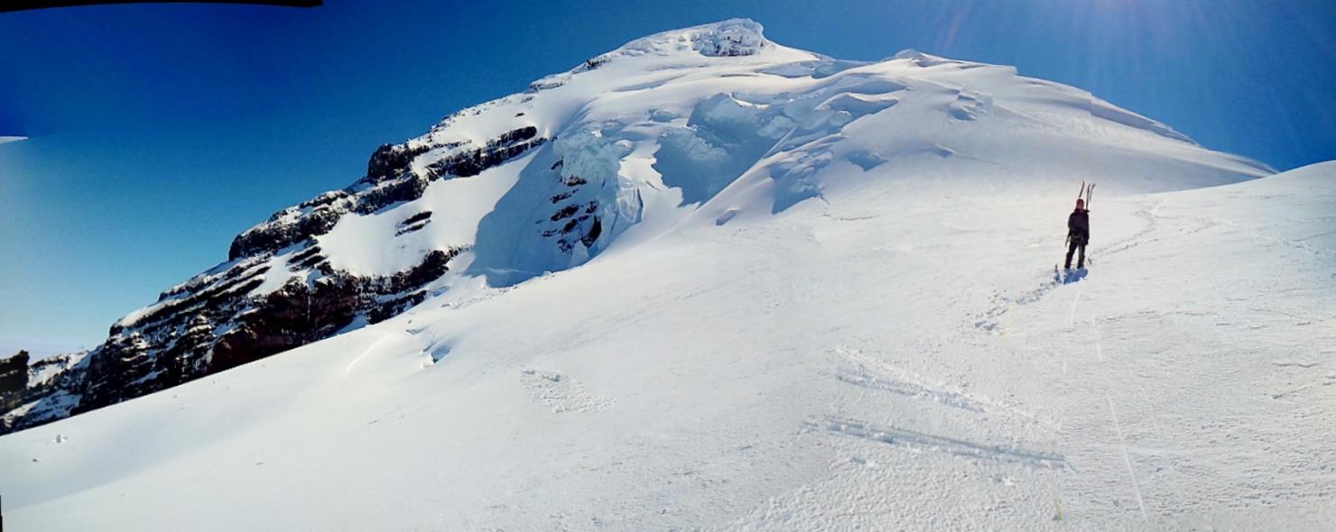
From 8000 feet we climbed steadily up to coleman saddle, happy to finally be able to see. Crossing the bergschrund was easy, though it did look like it had opened up a bit and then filled in again with last week's snow. The best crossing was right in the middle.
Turning the corner onto the pumice ridge, we had a great view of rainier, glacier, and the olympics popping up above the cloud layer. At this point it would have been straightforward to summit, but the day was warming quickly and our route-finding in the morning had put us a few hours behind schedule. Thinking about the NWAC warnings and strong sun, we opted to turn there and get ourselves out with a larger safety margin.
Descending down to camp, we were finally able to see the better routes across the glacier, but opted to just follow our old skin track in case visibility dropped again. Packed up, traversed back across to our ascent route west of the regular hogsback trail, and had great corn skiing all the way out to the edge of the forest. 0.2 miles from there to the TH, and another quarter mile on the road to the car.
All in all a great weekend.
Three of us set out on saturday morning, taking the standard heliotrope ridge trail from the TH. Before long, we realized it wasn't going to link up with the winter route (the one that starts behind the outhouse) so we bushwhacked to change course. 3 tricky creek crossings later and we were finally on snow, having gained only a few hundred feet in 1.5 hrs. Good times.
Continued on upward, hanging a left at the Y in the valley to start moving more eastward and eventually link up with the main climbers route. Around 6000 feet we ascended into the clouds, dropping visibility quickly. We ascended the steep head of the gully to where it meets the open and mellower slopes above, finding ourselves in 40 ft visibility once we reached the top.
At this point we had a mile or two of traversing to get over to Black Buttes camp. Not knowing the terrain very well and unable to see anything in the clouds and flat light, we roped up, plotted a bearing and set off. A few hours later we arrived near what we thought was our destination, but finding the actual camp was like finding a needle in a haystack, despite the GPS. Finding a flat spot on the glacier, we made camp around 8.
Left camp at 4am, again navigating by compass and gps to cross the coleman glacier. Ran into a party of 4 from Bellingham who turned shortly thereafter - no shame there, visibility was poor and the crevasses massive. Several hours and a long crevassed dead-end turnaround later, we popped out of the clouds into beautiful sunshine around 8000 feet. Fyi for those wondering, our route took us on a 96 degree bearing from the flats just below the black buttes. This turned out to be a bit lower than ideal for crevasse navigation right now - the better route would be to take the same bearing from right up against the buttes until reaching the turn below the coleman saddle.
From 8000 feet we climbed steadily up to coleman saddle, happy to finally be able to see. Crossing the bergschrund was easy, though it did look like it had opened up a bit and then filled in again with last week's snow. The best crossing was right in the middle.
Turning the corner onto the pumice ridge, we had a great view of rainier, glacier, and the olympics popping up above the cloud layer. At this point it would have been straightforward to summit, but the day was warming quickly and our route-finding in the morning had put us a few hours behind schedule. Thinking about the NWAC warnings and strong sun, we opted to turn there and get ourselves out with a larger safety margin.
Descending down to camp, we were finally able to see the better routes across the glacier, but opted to just follow our old skin track in case visibility dropped again. Packed up, traversed back across to our ascent route west of the regular hogsback trail, and had great corn skiing all the way out to the edge of the forest. 0.2 miles from there to the TH, and another quarter mile on the road to the car.
All in all a great weekend.
author=peggieh link=topic=25091.msg105949#msg105949 date=1339610158]
Did you see any bilers? Its always an annoyance to see snowmobiles raping the mountain after you've worked so hard to get somewhere where you were expecting peace, quiet, and solitude.
Two points.
1) There have already been numerous discussions about this, and the community has agreed that this topic does not belong on trip reports about climbing/skiing Mt. Baker.
2) Snowmobiling is legal on the south side. If you don't like that, I suggest you climb and ski something else.
Please rant about snowmobiling in the random tracks section.
Thanks for the conditions report - it looks like it was pretty nice up there above the clouds.
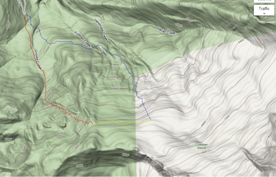
Your original route does sort of hook up with the grouse creek route at around 6500 ft. The ski down the grouse creek route is more open and fun, but the route up works either way. Heliotrope route is a little more direct to get to the actual glacier. Those trees you likely bushwhacked are pretty steep, eh?
author=joke link=topic=25091.msg105950#msg105950 date=1339611216]
Three of us set out on saturday morning, taking the standard heliotrope ridge trail from the TH. Before long, we realized it wasn't going to link up with the winter route (the one that starts behind the outhouse) so we bushwhacked to change course.
Your original route does sort of hook up with the grouse creek route at around 6500 ft. The ski down the grouse creek route is more open and fun, but the route up works either way. Heliotrope route is a little more direct to get to the actual glacier. Those trees you likely bushwhacked are pretty steep, eh?
Peggieh, perhaps you missed the threads regarding Baker last month as you might be new to the TAY forum.
very lengthly discussion about Baker and snowmobiles in 'random tracks':
http://www.turns-all-year.com/skiing_snowboarding/trip_reports/index.php?topic=24797.0
Mt.Baker trip report that turned into a thread about snowmobiles:
http://www.turns-all-year.com/skiing_snowboarding/trip_reports/index.php?topic=24851.0
Please note Marcus' request (second to last comment) in that last thread that maybe folks could limit the pro/con snowmobile talk to the random tracks thread and keep it outta trip reports.
author=peggieh link=topic=25091.msg105953#msg105953 date=1339613902]1.) WHAT? "the community" agrees?!?? Was there a vote? Nobody asked me or anyone I know. Or are you talking about the bile community?
2.) So if murder was legal on the south side I should just go somewhere else? No thats not how it works.
Just because its legal doesn't mean its right.
*on preview, thanks Pete*
Comparing snowmobile traffic on Mt. Baker to murder is a non-starter.
We've had several Baker trip reports this year so far, some of which have been derailed into extended discussions about snowmobile traffic and/or trespass. It's a topic lots of folks want to talk about, but it does not belong in the trip reports section -- if you'd like to start a discussion, you can start a thread in Random Tracks, or search that area of the site and bring up one of the threads from years past, where it's been discussed before. Please don't do it here.
author=joke link=topic=25091.msg105950#msg105950 date=1339611216]
Two points.
1) There have already been numerous discussions about this, and the community has agreed that this topic does not belong on trip reports about climbing/skiing Mt. Baker.
2) Snowmobiling is legal on the south side. If you don't like that, I suggest you climb and ski something else.
Please rant about snowmobiling in the random tracks section.
With some disrespect to Marcus and Joke, there are occasional incursions into Grouse Creek from snowmobiles off the upper sections of the Glacier Creek Rd. A request for information in this context should not be out of line.
But, now back to la la land and the realm of social delicacy...
Thanks for the map, Joke. We did our bushwhacking pretty early, so not too steep. I like that Grouse creek route - if you ascend during the traverse you can get straight up to the black buttes.
Also fyi the bridge on the standard trail is out, but the crossing there wasnt bad.
Also fyi the bridge on the standard trail is out, but the crossing there wasnt bad.
Reply to this TR
Please login first: