March 23, 2012, Rainier, Tatoosh Powder and Solitude
3/23/12
WA Cascades West Slopes South (Mt Rainier)
6169
1
After a 3-day closure due to snowfall and high avalanche danger, the road to Paradise would finally reopen on Friday. Jessie and I considered heading for Camp Muir given the forecast of partly sunny with fairly light winds at 10000 ft, but made a last-minute decision to divert to the Tatoosh Range to look for north-facing powder instead, especially given the chance of afternoon showers stated in the forecast. A very good call, it turned out.
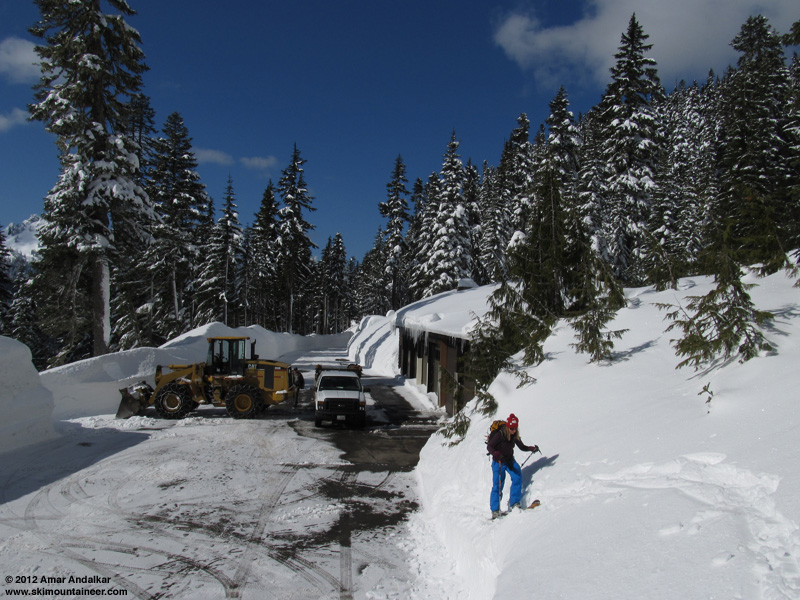
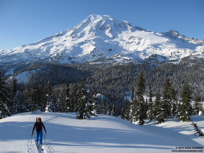
Got a leisurely start around 11am, breaking trail right from the Narada Falls parking lot, following traces of an old buried skin track up the forested hillside to Stevens Canyon Road. Passed a family of 3 snowshoers at the road, and they would be the last people or tracks we would see all day. Complete and utter solitude in a normally quite-busy area, on a partly sunny Friday no less. The untracked Tatoosh wilderness? Unbelievable!
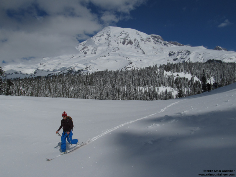
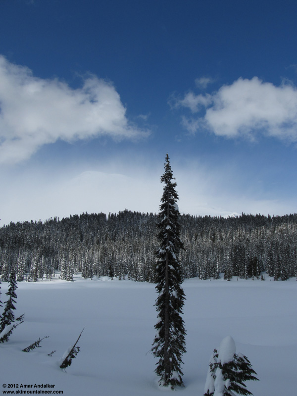
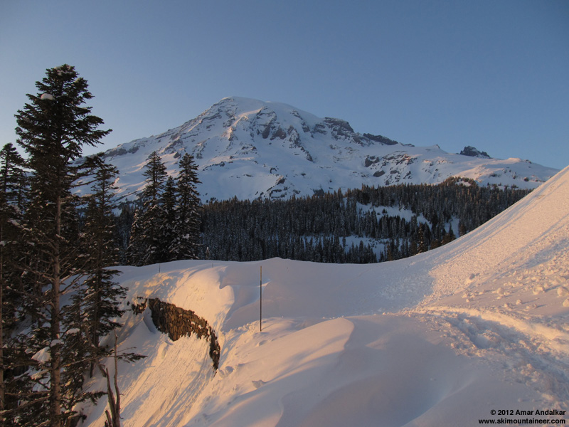
The morning started almost entirely clear and sunny, much more sunny than forecast. The clouds built throughout the day, and there were a few brief periods of light snow during the early afternoon, but always with sunshine still visible someplace in the vicinity.
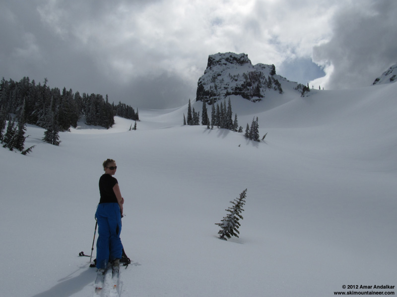
Broke trail up to a couple of standard high points around 6200 ft on either side of The Castle, then took runs down various north-facing lines into the open forest below down to about 5000 ft. Anything which was too flat or somewhat east-facing had gotten sun-affected, but northerly aspects were still nice medium-density powder, and they remained so all day through sunset.
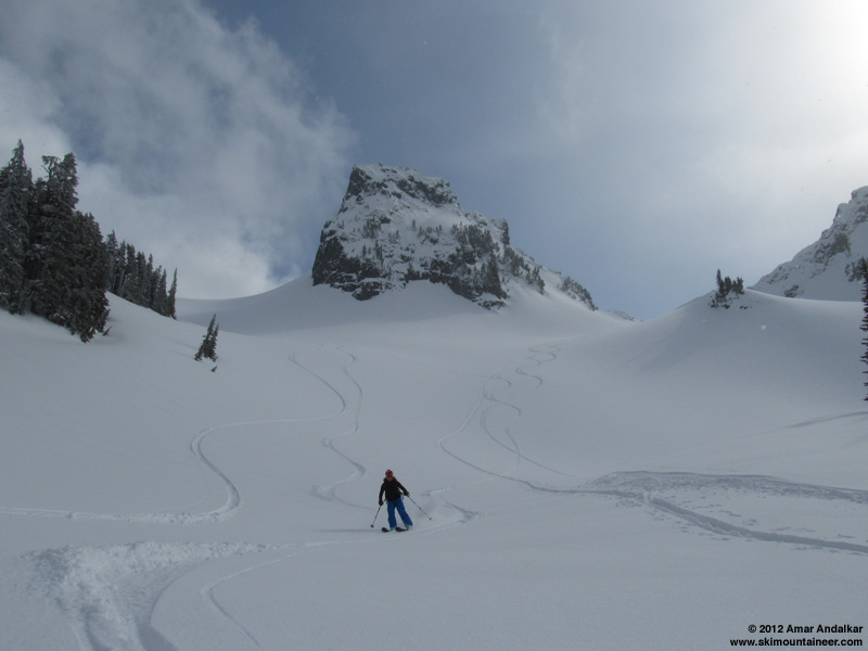
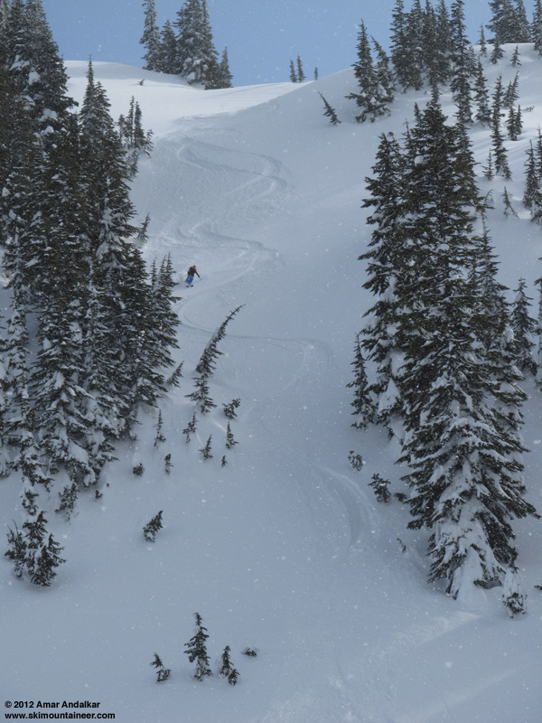
Skied 4 runs, about 5100 total vert for the day. Snow stability was excellent, and we observed no signs of instability on any slope we skied. A few minor rollers and pinwheels on sunny south and west aspects near the road, however.
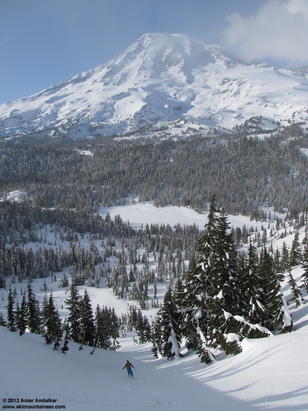
By late afternoon, the clouds had cleared and the magnificent Mountain was revealed in its entire splendor once again for our final run.
Back to the car a little after 7pm, just before sunset but with plenty of daylight to spare. Finally saw other people again for the first time in over 7 hours (a large incoming group of snowshoers) as we passed Inspiration Point on the road above Narada Falls.
An excellent day of powder skiing, all by ourselves yet within sight of a snow-covered road, in what is clearly someone else's top-secret powder stash!
[tt]MOUNT RAINIER RECREATIONAL FORECAST
NATIONAL WEATHER SERVICE SEATTLE WA
400 AM PDT FRI MAR 23 2012
SYNOPSIS...LIGHT SHOWERS COULD DEVELOP OVER MOUNT RAINIER THIS AFTERNOON AND EVENING...OTHERWISE TODAY THROUGH SATURDAY SHOULD BE DRY AND A LITTLE WARMER. MOISTURE MOVING NORTH FROM AN UPPER LOW MOVING INTO CALIFORNIA COULD BRING SOME SHOWERS TO THE PARK SATURDAY NIGHT AND SUNDAY. A WEAK UPPER TROUGH WILL BRING MORE SHOWERS MONDAY. THE FIRST IN A SERIES OF PACIFIC FRONTAL SYSTEMS WILL ARRIVE TUESDAY....FOR AN ACTIVE WEATHER PATTERN NEXT WEEK.
FRIDAY...PARTLY SUNNY. A CHANCE OF SHOWERS IN THE AFTERNOON. SNOW LEVEL 2000 FEET.
FRIDAY NIGHT...MOSTLY CLOUDY. A CHANCE OF SHOWERS IN THE EVENING. SNOW LEVEL 3500 FEET.
SATURDAY...PARTLY SUNNY. FREEZING LEVEL 4500 FEET.
SATURDAY NIGHT...MOSTLY CLOUDY WITH A CHANCE OF SHOWERS. SNOW LEVEL 4500 FEET.
SUNDAY...PARTLY SUNNY WITH A CHANCE OF SHOWERS. SNOW LEVEL 3500 FEET.
TEMPERATURE AND WIND FORECASTS FOR SELECTED LOCATIONS.
FRI FRI SAT SAT SUN
NIGHT NIGHT
SUMMIT (14411 FT) -7 -1 1 1 3
SW 20 S 25 S 30 S 45 S 35
CAMP MUIR(10188 FT) 7 19 16 19 23
S 15 S 20 S 25 S 30 SE 20
PARADISE (5420 FT) 37 26 45 28 44
S 10 NE 10 NE 10 N 10 N 10
LONGMIRE (2700 FT) 42 26 50 28 53
SE 10 E 10 NE 10 NE 10 NE 10
EXTENDED FORECAST...
SUNDAY NIGHT...MOSTLY CLOUDY WITH A CHANCE OF SHOWERS. SNOW LEVEL 4000 FEET.
MONDAY...MOSTLY CLOUDY WITH A CHANCE OF SHOWERS. SNOW LEVEL 4500 FEET.
MONDAY NIGHT...CLOUDY WITH A CHANCE OF SNOW AND RAIN. SNOW LEVEL 3500 FEET.
TUESDAY...SNOW AND RAIN. SNOW LEVEL 4000 FEET.
TUESDAY NIGHT...SNOW AND RAIN. SNOW LEVEL 4000 FEET.
WEDNESDAY...SNOW AND RAIN. SNOW LEVEL 3500 FEET.
WEDNESDAY NIGHT...SNOW AND RAIN. SNOW LEVEL 4000 FEET.
THURSDAY...SNOW AND RAIN. SNOW LEVEL 4000 FEET.
[/tt]
Got a leisurely start around 11am, breaking trail right from the Narada Falls parking lot, following traces of an old buried skin track up the forested hillside to Stevens Canyon Road. Passed a family of 3 snowshoers at the road, and they would be the last people or tracks we would see all day. Complete and utter solitude in a normally quite-busy area, on a partly sunny Friday no less. The untracked Tatoosh wilderness? Unbelievable!
The morning started almost entirely clear and sunny, much more sunny than forecast. The clouds built throughout the day, and there were a few brief periods of light snow during the early afternoon, but always with sunshine still visible someplace in the vicinity.
Broke trail up to a couple of standard high points around 6200 ft on either side of The Castle, then took runs down various north-facing lines into the open forest below down to about 5000 ft. Anything which was too flat or somewhat east-facing had gotten sun-affected, but northerly aspects were still nice medium-density powder, and they remained so all day through sunset.
Skied 4 runs, about 5100 total vert for the day. Snow stability was excellent, and we observed no signs of instability on any slope we skied. A few minor rollers and pinwheels on sunny south and west aspects near the road, however.
By late afternoon, the clouds had cleared and the magnificent Mountain was revealed in its entire splendor once again for our final run.
Back to the car a little after 7pm, just before sunset but with plenty of daylight to spare. Finally saw other people again for the first time in over 7 hours (a large incoming group of snowshoers) as we passed Inspiration Point on the road above Narada Falls.
An excellent day of powder skiing, all by ourselves yet within sight of a snow-covered road, in what is clearly someone else's top-secret powder stash!
[tt]MOUNT RAINIER RECREATIONAL FORECAST
NATIONAL WEATHER SERVICE SEATTLE WA
400 AM PDT FRI MAR 23 2012
SYNOPSIS...LIGHT SHOWERS COULD DEVELOP OVER MOUNT RAINIER THIS AFTERNOON AND EVENING...OTHERWISE TODAY THROUGH SATURDAY SHOULD BE DRY AND A LITTLE WARMER. MOISTURE MOVING NORTH FROM AN UPPER LOW MOVING INTO CALIFORNIA COULD BRING SOME SHOWERS TO THE PARK SATURDAY NIGHT AND SUNDAY. A WEAK UPPER TROUGH WILL BRING MORE SHOWERS MONDAY. THE FIRST IN A SERIES OF PACIFIC FRONTAL SYSTEMS WILL ARRIVE TUESDAY....FOR AN ACTIVE WEATHER PATTERN NEXT WEEK.
FRIDAY...PARTLY SUNNY. A CHANCE OF SHOWERS IN THE AFTERNOON. SNOW LEVEL 2000 FEET.
FRIDAY NIGHT...MOSTLY CLOUDY. A CHANCE OF SHOWERS IN THE EVENING. SNOW LEVEL 3500 FEET.
SATURDAY...PARTLY SUNNY. FREEZING LEVEL 4500 FEET.
SATURDAY NIGHT...MOSTLY CLOUDY WITH A CHANCE OF SHOWERS. SNOW LEVEL 4500 FEET.
SUNDAY...PARTLY SUNNY WITH A CHANCE OF SHOWERS. SNOW LEVEL 3500 FEET.
TEMPERATURE AND WIND FORECASTS FOR SELECTED LOCATIONS.
FRI FRI SAT SAT SUN
NIGHT NIGHT
SUMMIT (14411 FT) -7 -1 1 1 3
SW 20 S 25 S 30 S 45 S 35
CAMP MUIR(10188 FT) 7 19 16 19 23
S 15 S 20 S 25 S 30 SE 20
PARADISE (5420 FT) 37 26 45 28 44
S 10 NE 10 NE 10 N 10 N 10
LONGMIRE (2700 FT) 42 26 50 28 53
SE 10 E 10 NE 10 NE 10 NE 10
EXTENDED FORECAST...
SUNDAY NIGHT...MOSTLY CLOUDY WITH A CHANCE OF SHOWERS. SNOW LEVEL 4000 FEET.
MONDAY...MOSTLY CLOUDY WITH A CHANCE OF SHOWERS. SNOW LEVEL 4500 FEET.
MONDAY NIGHT...CLOUDY WITH A CHANCE OF SNOW AND RAIN. SNOW LEVEL 3500 FEET.
TUESDAY...SNOW AND RAIN. SNOW LEVEL 4000 FEET.
TUESDAY NIGHT...SNOW AND RAIN. SNOW LEVEL 4000 FEET.
WEDNESDAY...SNOW AND RAIN. SNOW LEVEL 3500 FEET.
WEDNESDAY NIGHT...SNOW AND RAIN. SNOW LEVEL 4000 FEET.
THURSDAY...SNOW AND RAIN. SNOW LEVEL 4000 FEET.
[/tt]
Very good call, indeed. I was hoping to get back out there after great powder the previous weekend but ended up catching up on work. Glad someone got after it. Thanks for the stability report.
Reply to this TR
Please login first: