March 9 - 11 Mt Hood Traverse
3/15/12
OR Mt Hood
4712
6
Mount Hood Traverse March 9 11
This past weekend a group of 4 attempted a ski circumnavigation of Mt Hood. We were forced to abandon our intended route on day three due to deteriorating weather and snow stability.
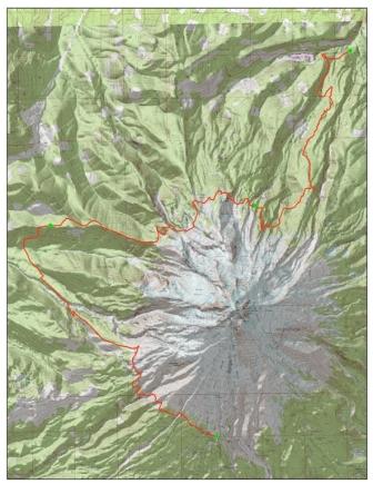
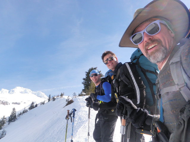
Our trip began Friday morning at the timberline parking lot. We finished packing and were on trail around 9am. We had blue bird sky and what felt like spring corn. We had excellent views of the surround volcanoes; St Helens and Adams to the north and Jefferson, The Sisters and Bachelor to the south. It was a beautiful day to be out in the mountains. We made good progress across the west side of the mountain and descended down into the Sandy River Valley. From there, we ascended the ridge to the north, partly in the dark, and established our first camp west of Bald Mountain at around 7pm. We were entertained by a nice campfire and enjoyed our well earned rest after an 18 mile day.
On Saturday, we were on the move before 7am and made good progress around the north side of the mountain. Weather was a mix of light snow and sun breaks. Snow conditions were similar to the previous day with a light dusting atop the rain crust from the previous weekend. We enjoyed some nice turns as we dropped into Elk Cove, then ascended some minor ridges in the Coe drainage and established our second camp. We covered approx. 10 miles and took about 12 hours. We encountered some icy slopes in Cairn Basin that required some boot packing and circuitous route finding. This wasted time and had some of us regretting not bringing our ice axes and crampons.
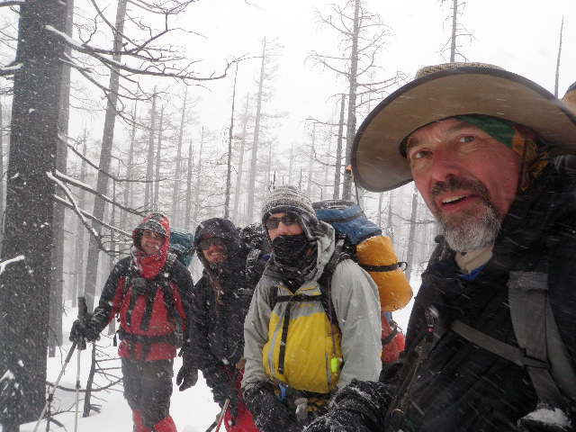
While packing up on Sunday morning we were greeted to the roaring sounds of 5 or 6 natural avalanches in the surrounding hills. This certainly was an ominous way to start out the day. Around the campfire the night before, we were able to get cell service and checked the latest weather reports and avy conditions. Things were not looking good. By the mid-afternoon we found ourselves in blizzard conditions with wind gusts that were strong enough to push around a bit. We reached the Elliot drainage and were impressed by the sizable canyon it occupies. After some careful route finding and discussion amongst the group we decided to abandon our plans of a circum-ski. We decided to bail down Stranahan Ridge. We were able to call and arrange a pick up on the Clear Creek Road. We crossed the Coe for a second time and skied out logging roads to Laurance Lake where we met our ride and returned to timberline.
Although we were unable to finish the route, everyone was pleased to spend time traveling the mountains with skis (tele light = 3pin and XCD skis). We covered approx 40 miles in three days and I have the blisters to prove it. All in all, a great trip with great company. And maybe most importantly, we live to ski another day. Special thanks to D for organizing the trip and putting everything together. Hopefully we can return soon and finish the tour.
Images are:
1)a map of the route we took with TH and campsites
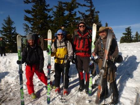
2)group pic Friday
3)group pic sunday
This past weekend a group of 4 attempted a ski circumnavigation of Mt Hood. We were forced to abandon our intended route on day three due to deteriorating weather and snow stability.
Our trip began Friday morning at the timberline parking lot. We finished packing and were on trail around 9am. We had blue bird sky and what felt like spring corn. We had excellent views of the surround volcanoes; St Helens and Adams to the north and Jefferson, The Sisters and Bachelor to the south. It was a beautiful day to be out in the mountains. We made good progress across the west side of the mountain and descended down into the Sandy River Valley. From there, we ascended the ridge to the north, partly in the dark, and established our first camp west of Bald Mountain at around 7pm. We were entertained by a nice campfire and enjoyed our well earned rest after an 18 mile day.
On Saturday, we were on the move before 7am and made good progress around the north side of the mountain. Weather was a mix of light snow and sun breaks. Snow conditions were similar to the previous day with a light dusting atop the rain crust from the previous weekend. We enjoyed some nice turns as we dropped into Elk Cove, then ascended some minor ridges in the Coe drainage and established our second camp. We covered approx. 10 miles and took about 12 hours. We encountered some icy slopes in Cairn Basin that required some boot packing and circuitous route finding. This wasted time and had some of us regretting not bringing our ice axes and crampons.
While packing up on Sunday morning we were greeted to the roaring sounds of 5 or 6 natural avalanches in the surrounding hills. This certainly was an ominous way to start out the day. Around the campfire the night before, we were able to get cell service and checked the latest weather reports and avy conditions. Things were not looking good. By the mid-afternoon we found ourselves in blizzard conditions with wind gusts that were strong enough to push around a bit. We reached the Elliot drainage and were impressed by the sizable canyon it occupies. After some careful route finding and discussion amongst the group we decided to abandon our plans of a circum-ski. We decided to bail down Stranahan Ridge. We were able to call and arrange a pick up on the Clear Creek Road. We crossed the Coe for a second time and skied out logging roads to Laurance Lake where we met our ride and returned to timberline.
Although we were unable to finish the route, everyone was pleased to spend time traveling the mountains with skis (tele light = 3pin and XCD skis). We covered approx 40 miles in three days and I have the blisters to prove it. All in all, a great trip with great company. And maybe most importantly, we live to ski another day. Special thanks to D for organizing the trip and putting everything together. Hopefully we can return soon and finish the tour.
Images are:
1)a map of the route we took with TH and campsites
2)group pic Friday
3)group pic sunday
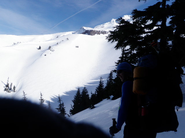
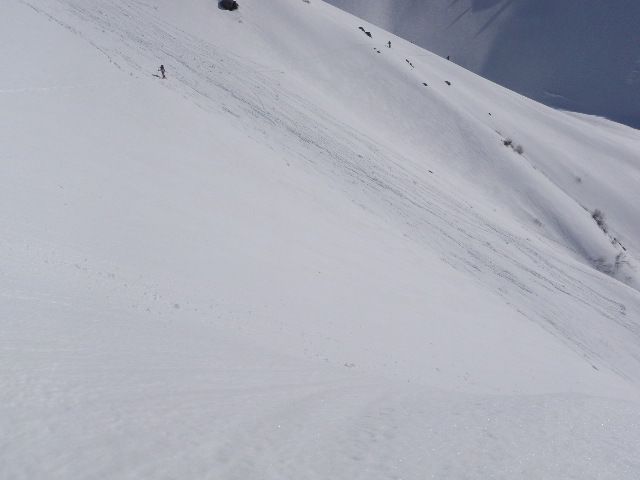
Here's a few more shots of the adventure. Nice writeup Phil.
Next circumnavigation is April 6-9 of Mt. St. Helens.
Let me know if interested.
Cheers
David
Next circumnavigation is April 6-9 of Mt. St. Helens.
Let me know if interested.
Cheers
David
More pictures (and the new Circumnavigation of Helen's trip) at http://www.meetup.com/Portlands-Hard-Core-Explore/events/51881982/

Way cool!
Now, where is this place???? kidding--making light of the hot air still going on in the Random Tracks thread
Thanks for sharing and bless the fish scale!
John
Now, where is this place???? kidding--making light of the hot air still going on in the Random Tracks thread
Thanks for sharing and bless the fish scale!
John
nice work boys !!
I have done the high circumnavigation in early summer on skis at ~8500', and the low one twice on foot (on the timberline trail). My hat is off to you folks for just the attempt. Very ambitious indeed.
From a terrain standpoint what did you consider to be the toughest element. In summer I always found the water crossings difficult. How are they on skis? Ron
From a terrain standpoint what did you consider to be the toughest element. In summer I always found the water crossings difficult. How are they on skis? Ron
little issue with water. Streams, when open, are running low.
The challanges are the canyons. 45 degree, avy potential. Which is perhaps why the high orbit is a better choice-providing a blue bird day and soft edgable snow.
cheers
David
The challanges are the canyons. 45 degree, avy potential. Which is perhaps why the high orbit is a better choice-providing a blue bird day and soft edgable snow.
cheers
David
author=rong link=topic=24128.msg102066#msg102066 date=1331845413]
I have done the high circumnavigation in early summer on skis at ~8500', and the low one twice on foot (on the timberline trail). My hat is off to you folks for just the attempt. Very ambitious indeed.
From a terrain standpoint what did you consider to be the toughest element. In summer I always found the water crossings difficult. How are they on skis? Ron
Reply to this TR
Please login first: