- Posts: 371
- Thank you received: 0
Weather pattern change?
- Jeff Huber
- [Gaper_Jeffey]
-
 Topic Author
- Offline
- Senior Member
-

Less
More
24 Feb 2005 08:03 - 24 Feb 2005 08:05 #171014
by Jeff Huber
Weather pattern change? was created by Jeff Huber
From the
Portland discussion
:<br>
")
<br><br>From the Seattle discussion :<br>.LONG TERM...MODELS REASONABLY CLOSE IN SHOWING PATTERN CHANGE<br> STARTING ON SUN. BLOCKING PATTERN BREAKING DOWN. GFS FASTEST WITH<br> THIS MAY BE A LITTLE FAST AS INITIAL SYSTEMS TEND TO BE SLOWER AND<br> WEAKER INTO BLOCK. WILL GO WITH INITIAL BEST THREAT SUN NIGHT AS<br> LOW NEAR 40 N LIFTS NE INTO AREA. 18Z ETA ALSO SHOWS THIS TIMING.<br> SYSTEM LIFTS N OVER AREA MON INTO MON NIGHT. 12Z EURO SHOWS MORE<br> SIGNIFICANT WESTERLY SYSTEM BREAKING THROUGH INTO AREA TUE. GFS<br> STILL FASTER SHOWING SYSTEM MON NIGHT. WILL LET LATER FORECASTS<br> RESOLVE TIMING BETTER. EURO GFS EACH SHOW SYSTEM OVER AREA THEN<br> BACKS FL0W AS TROUGH DEEPENS WELL OFFSHORE ON WED. WILL LEAVE BROAD<br> BRUSH THREAT OF RAIN MON NIGHT THROUGH THU THOUGH SOMEWHERE IN THIS<br> TIME FRAME SOLID THREAT OF PRECIPITATION EXISTS. KOSOVITZ
<br><br>Anyone want to start a weather betting pool?OTHER BIG CHANGE IS EARLY NEXT WEEK. WITH RECENT MODEL INCONSISTENCY IN RESOLVING THE EVOLUTION OF THE SPLIT FLOW OFFSHORE NEXT WEEK HAVE BEEN HOLDING WITH PARTLY CLOUDY AND DRY. RECENT GFS RUNS AND NOW 00Z ECMWF HAVE BEEN BRINGING A LOW UP ACROSS OREGON. 06Z GFS ENSEMBLES HAVE AT LEAST HALF THE SOLUTIONS SUPPORTING THIS TREND. CONSENSUS WITH PQR IS TO INTRODUCE A CHANCE OF RAIN EARLY NEXT WEEK...STARTING ON MONDAY FOR WRN WA....SUNDAY NIGHT EARLIER FOR OREGON. THE SUNNY AND DRY SPELL HAD TO COME TO AN END EVENTUALLY
Please Log in or Create an account to join the conversation.
- markharf
- [markharf]
-
- Offline
- Senior Member
-
Less
More
- Posts: 339
- Thank you received: 3
24 Feb 2005 08:13 #171015
by markharf
Replied by markharf on topic Re: Weather pattern change?
Who would've thought we'd be reduced to giddiness at the mere mention of "a chance of rain" four days out?
Please Log in or Create an account to join the conversation.
- Amar Andalkar
- [andalkar]
-
- Offline
- Premium Member
-

Less
More
- Posts: 635
- Thank you received: 0
24 Feb 2005 14:19 #171022
by Amar Andalkar
Replied by Amar Andalkar on topic Re: Weather pattern change?
I hate to be a pessimist, Jeff, but it sure looks like the upcoming storm cycle is once again going to follow this winter's unusual and persistent pattern: another series of cutoff lows aimed squarely at CA, with slim pickings of wraparound moisture in OR and WA. The
QPF forecast
is already hinting at 2-3 ft of new snow for the CA Cascades and Sierra on Monday-Tuesday, with more snow likely during the rest of the week. The biggest difference I can see from previous storms? Maybe I'll be in Tahoe this time instead of in Seattle!!!<br><br>By the way, it seems likely that nearly every measurement site in the Cascades from Mt Baker to Mt Hood will reach record-low snowdepths as of March 1, below even the drought year of 1977. The monthly outlook for March was just posted last week by the
Climate Prediction Center
, and it bears little hope for a major shift in this winter's seasonal pattern.<br>
Please Log in or Create an account to join the conversation.
- Michael
- [Michael]
-
- Offline
- New Member
-

Less
More
- Posts: 36
- Thank you received: 0
24 Feb 2005 15:58 #171025
by Michael
Replied by Michael on topic Re: Weather pattern change?
Hmmm - I guess we will have to go to California now > <br><br>Meanwhile, talking about unusual weather patterns, look at what the cold weather has done in Geneva:
www.flickr.com/photos/zorba/sets/106439/show/
<br>Looking at this makes me think it's not all that bad here ;D
<br><br>Meanwhile, talking about unusual weather patterns, look at what the cold weather has done in Geneva:
www.flickr.com/photos/zorba/sets/106439/show/
<br>Looking at this makes me think it's not all that bad here ;D
<br><br>Meanwhile, talking about unusual weather patterns, look at what the cold weather has done in Geneva:
www.flickr.com/photos/zorba/sets/106439/show/
<br>Looking at this makes me think it's not all that bad here ;D Please Log in or Create an account to join the conversation.
- Amar Andalkar
- [andalkar]
-
- Offline
- Premium Member
-
Less
More
- Posts: 635
- Thank you received: 0
24 Feb 2005 17:21 #171026
by Amar Andalkar
Replied by Amar Andalkar on topic Re: Weather pattern change?
Wow, Michael, those are the most amazing ice storm photos I've ever seen. I just had to grab one photo and post it in this thread: <br><br>
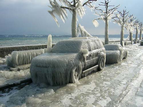 <br><br>Did the ice come from freezing rainfall or from windblown water from the lake? Because in some of the photos, the buildings behind the vehicles appear to be ice-free. <br><br>I went through a similar but less intense ice storm during my senior year of college in 1994, as much of the Eastern Seaboard was hit with a massive ice storm of torrential freezing rain. All of New Jersey was coated with 2-3 inches of solid ice, followed by cold temps which refused to allow it to melt for the next week. It's the only time I've ever wanted crampons just to walk across campus to class. <br>
Please Log in or Create an account to join the conversation.
- Michael
- [Michael]
-
- Offline
- New Member
-
Less
More
- Posts: 36
- Thank you received: 0
25 Feb 2005 02:44 #171030
by Michael
Replied by Michael on topic Re: Weather pattern change?
I think the ice mostly came from the lake, transported by the wind. It's been cold over there for a long time now. Even their banks closed at some point - for that to happen in Switzerland you know that it must be really bad ") <br><br>Skiing is amazing though, so for those who were considering to go to Europe for skiing - this is the year!!
<br><br>Skiing is amazing though, so for those who were considering to go to Europe for skiing - this is the year!!
<br><br>Skiing is amazing though, so for those who were considering to go to Europe for skiing - this is the year!! Please Log in or Create an account to join the conversation.
- skip
- [skip]
-
- Offline
- Junior Member
-

Less
More
- Posts: 94
- Thank you received: 0
25 Feb 2005 04:09 #171031
by skip
Replied by skip on topic Re: Weather pattern change?
Thank for the pics, Michael. I hadn't heard about this prior to your post, so I wrote to my friend Denny in Geneva to get the skinny. In addition to info you have here, he added this is resultant of a wet 80+ mph of cold wind, and that 52 boats sank from the weight of the ice.<br><br>Crazy.
Please Log in or Create an account to join the conversation.
- Jeff Huber
- [Gaper_Jeffey]
-
Topic Author
- Offline
- Senior Member
-
Less
More
- Posts: 371
- Thank you received: 0
28 Feb 2005 10:10 - 28 Feb 2005 10:11 #171070
by Jeff Huber
Replied by Jeff Huber on topic Re: Weather pattern change?
Amar is correct, again. The
PDX discussion
posted a few house ago:<br>
<br><br>I plan to do a lot of driving south this Spring.LONG TERM...(FRIDAY THROUGH MONDAY) SPLIT-FLOW PATTERN WILL CONTINUE OVER THE EASTERN PACIFIC FRI. DRY CONDITIONS WITH ABOVE NORMAL TEMPERATURES LIKELY DURING THE WEEKEND AND INTO EARLY NEXT WEEK.<br><br>HAVE BACKED OFF ON PRECIP CHANCES THU NIGHT AND FRI. THE PAST COUPLE OF DAYS THE MEDIUM RANGE MODELS WERE GENERALLY ADVERTISING A SERIES OF SYSTEMS TO MOVE ACROSS THE AREA DURING THE MIDDLE AND LATTER PORTIONS OF THIS WEEK. NOW IT IS BACK TO A SPLIT PATTERN WITH THE MAIN ENERGY HEADING SOUTH ALONG THE CALIFORNIA COAST...AS HAS BEEN THE CASE ALL WINTER. SPAGHETTI CHARTS VALID FRI SHOW SOME UNCERTAINTY AS TO THE OVERALL PATTERN...BUT THE 00Z RUN AND OPERATIONAL GFS RUN FAIRLY SIMILAR WITH TROUGHINESS OVER CALIFORNIA. THE ECMWF AND UKMET ALSO INDICATING CLOSED UPPER LOW NEAR KSFO 00Z SAT. 00Z CANADIAN GIVES A DIFFERENT SOLUTION...WITH THE UPPER TROUGH FURTHER WEST...OUT AT 130W. LEFT CHANCE POPS FRI WITH SPLITTING SYSTEM AND POTENTIAL DEFORMATION ZONE OVER EXTREME SRN OREGON. SUSPECT THE FORECAST AREA WILL END UP DRY. SAT STARTS THE NEXT DRY SPELL AS 500 MB RIDGING BUILDS OVER THE PAC NW. SPAGHETTI CHARTS VALID 00Z SUN MUCH MORE IN TUNE...WITH JUST A COUPLE OUTLIER MEMBERS. UPPER LEVEL RIDGE TO HOLD FIRM SUN THRU THE MIDDLE OF NEXT WEEK. ECMWF ADVERTISES 1000-500 MB THICKNESS VALUES IN THE MID 550S SUN AND MON WITH 850 MB TEMPS AROUND 10C. THIS WOULD TRANSLATE TO AT LEAST LOWER TO MID 60S IN SEVERAL AREAS. THE 8-14 DAY PROGS DO NOT BODE WELL FOR TRYING TO MAKE UP THE CURRENT PRECIP DEFICIT. THE GFS MAINTAINS A REX BLOCK PATTERN THROUGH AT LEAST DAY 13 (MARCH 13). WEISHAAR
Please Log in or Create an account to join the conversation.