Feb 19-20, 2012, Sasse Ridge
2/19/12
3895
5
Jane and I decided to try the Cle Elum valley this last Sunday Monday, despite the snow depth. We were not sure how far we could get but we decided to try our usual area, hoping to be able to get to one of the alternative campsites that we had previously scoped out for such purposes. There was about a foot of heavy new snow on the valley floor, making for slow going until we got into the trees. That made quite a difference, such that we managed to get to one of our sites at about 3000+ feet. The last 100 yards or so was in the open, and by then the snow depth was ~20 inches, and it was clear that it was not worth it to try to go further. Besides, the spot we chose is quite nice, with a pleasant view to the north.
The sun came out around midday and we were aware of the very rapid increase in the avalanche risk on affected slopes, reassuringly all a long way from our location. Based on the snowpack model, we expected that the snow depth would continue to increase rapidly with elevation up from our campsite, and we felt that it was unlikely that we could even get to anyplace we would feel not that risky and worth more than a few turns on Monday morning, so we just packed up and skied out.
Ive posted a few pics here:
https://skydrive.live.com/?cid=d9374555cbe355aa&id=D9374555CBE355AA%21523#cid=D9374555CBE355AA&id=D9374555CBE355AA%21523
I included a picture of my home made snow brush for Marcus, although I may have done this sometime in the past. (Im running out of unnecessary gear to discuss.) REI used to sell simple snow brushes years ago, but I have not seen them for some time. They are a big help in brushing snow off clothes and particularly boots prior to putting them in the tent. It really helps to keep from bringing snow inside, which then can become that much more water vapor that slows drying things out. My brush was made by stuffing a section of 1 inch aluminum tubing with plastic bristles from an old brush, and crimping it in a vise. You then saw off the excess.
By the way, those wishing to ski up road 4315 beyond the groomed part on standard cross country gear may wish to make alternate plans for a while. The snowmobile tracks from Sunday may make the descent back down unpleasant to dangerous, depending on ones skill level on skinny skis. I might mention that if you choose the right conditions (hard base with a few inches new), you can make it all the way to the top of Jolly Mtn. in a very short time on steel edged fish scale XC skis.
Larry
Hey Larry! Thanks for the PM -- sickness and other events conspired to keep me from trying to catch up to you two on Monday. Great pics :)


Always love seeing your TRs. I always try and figure where you are by the pics... Do you ever go up the road to Sasse mt trail that is just past the Last restort? I went up that a couple of weeks back just trying to get a lay of the land.
DAN
DAN
author=hyakSS link=topic=23819.msg100834#msg100834 date=1329890400]
... Do you ever go up the road to Sasse mt trail that is just past the Last restort? DAN
Thanks Dan,
No, I've not been up that road. If it's the one I'm thinking of, it's more or less a standard snomobile route. A bit farther down the road is the route to Hex Mountain, which you can spot by the signed and plowed parking area on the west side of the road. Or maybe that's where you went!
http://www.wta.org/go-hiking/hikes-of-the-week/hex-mountain-snowshoe
It seems quite popular with snowshoers and XC skiers judging by the number of cars we see parked there.
Larry
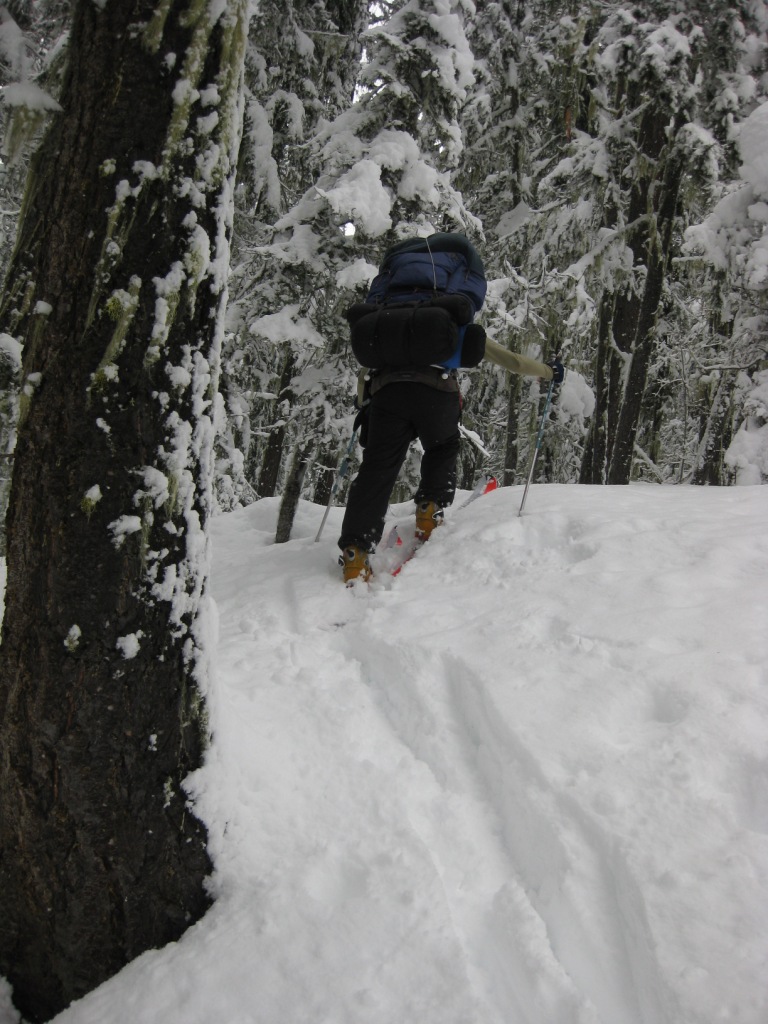
Here is a good photo to indicate the snow depth in the trees heading up the rib on the south side Salmon la Sac creek. The snow stuck to the tree indicates wind direction and old mans beard still attached shows how much more sheltered this route is than just 50 feet away where the snow depth is more than double.
Jane
Jane
author=Larry_R link=topic=23819.msg100850#msg100850 date=1329921103]
Thanks Dan,
No, I've not been up that road. If it's the one I'm thinking of, it's more or less a standard snomobile route. A bit farther down the road is the route to Hex Mountain, which you can spot by the signed and plowed parking area on the west side of the road. Or maybe that's where you went!
http://www.wta.org/go-hiking/hikes-of-the-week/hex-mountain-snowshoe
It seems quite popular with snowshoers and XC skiers judging by the number of cars we see parked there.
Larry
You are right, the one i went up was a snomo freeway. I will check out the hex mt trail next time. Thanks
Dan
Reply to this TR
Please login first: