Feb 11, 2012, Camp Muir
2/11/12
WA Cascades West Slopes South (Mt Rainier)
4487
8
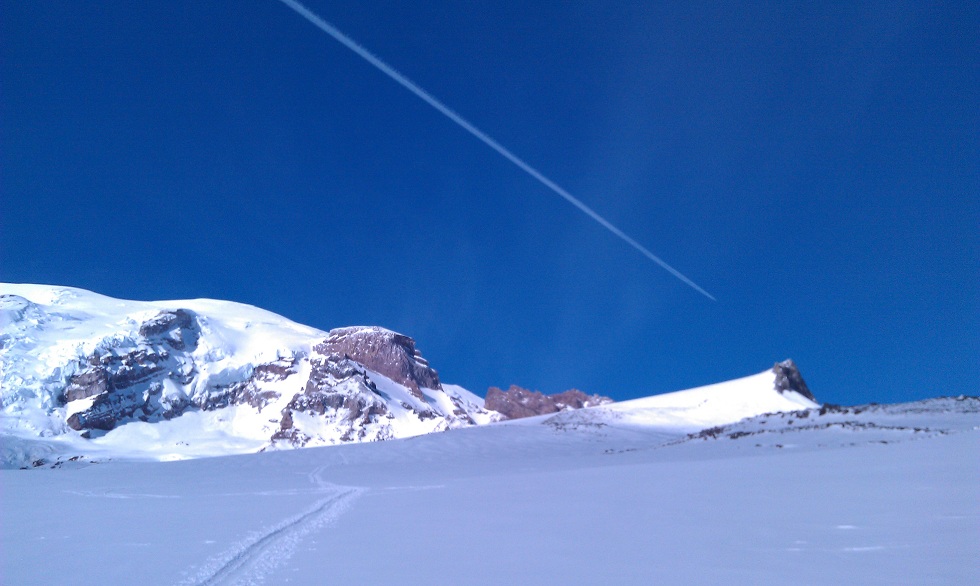
Ascended through fairly thick clouds and lightly falling snow to about 8000 ft, after which it was fairly clear and blue skies, towards the north at least; lots of cloud bands in the southern skies. Had views of about roughly the 6K to 10K swath of Mt. Adams's slopes.
My first time going to Muir since July 2010 when I summited the mountain for the first time, via the DC. Also my first solo wintertime trip to Muir! 8) Had been in the winter before, and been solo before, but never solo in winter. As we all know though, you're never really alone on this route. Saw a total of about 20 people past the top of Pan Point... maybe seven snowshoers (four day trippers I think and three with overnight packs and climbing gear). And about 12 day trip skiiers total, most of which were in this party of about seven who at about 9K departed the route to head west towards, I'm guessing, the Nisqually chutes.
Didn't see a single person at Camp Muir, but I didn't walk around there much. The hut for one thing was totally empty.
Overall for most of the route, there was about 2-4" of new snow. And had practically no wind all day, which was nice. ;D
Wow, thanks for the report, that looks nice! Really surprising that it was so sunny above the clouds. Even though I go there all the time, I'm kicking myself now for missing this day -- always love the sunny days above a sea of clouds. But just did not see it coming in the forecasts or the UW model, maybe I didn't look carefully enough.
I'm just curious, since you don't go there regularly, how did you pick this one day for a solo winter trip to Muir? Did you have some idea that it would be clear up there? Or were you just going up to take a look, come what may? The forecast gave no hint of clear skies, although it did predict the light winds correctly.
MOUNT RAINIER RECREATIONAL FORECAST
NATIONAL WEATHER SERVICE SEATTLE WA
336 AM PST SAT FEB 11 2012
SYNOPSIS...A LOW PRESSURE SYSTEM OFFSHORE WILL MOVE INLAND TODAY WITH RAIN MAINLY ALONG THE COAST AND SOUTH PART. A WEAK FRONTAL SYSTEM WILL BRING A CHANCE OF RAIN TO THE AREA SUNDAY AND EARLY MONDAY. THE WEATHER WILL REMAIN UNSETTLED NEXT WEEK.
SATURDAY...SHOWERS LIKELY EARLY THIS MORNING...THEN MOSTLY CLOUDY WITH A CHANCE OF SHOWERS IN THE LATE MORNING AND AFTERNOON. SNOW LEVEL 3500 FEET.
SATURDAY NIGHT...CLOUDY. A CHANCE OF SHOWERS IN THE EVENING... THEN A CHANCE OF SNOW AND RAIN AFTER MIDNIGHT. SNOW LEVEL 3000 FEET.
SUNDAY...MOSTLY CLOUDY WITH A CHANCE OF SNOW AND RAIN. SNOW LEVEL 3000 FEET.
SUNDAY NIGHT...SNOW LIKELY AND A CHANCE OF RAIN. SNOW LEVEL 2500 FEET.
MONDAY...CLOUDY WITH A CHANCE OF SNOW AND RAIN. SNOW LEVEL 2000 FEET.
TEMPERATURE AND WIND FORECASTS FOR SELECTED LOCATIONS.
SAT SAT SUN SUN MON
NIGHT NIGHT
SUMMIT (14411 FT) 1 4 5 1 0
SW 11 NW 16 W 14 NW 11 N 10
CAMP MUIR(10188 FT) 16 15 16 15 14
SW 6 NW 8 W 10 N 10 NE 9
PARADISE (5420 FT) 35 26 35 26 34
SW 4 SW 2 S 2 SW 2 S 1
LONGMIRE (2700 FT) 37 31 37 30 36
CALM CALM CALM CALM CALM
++ TEMPERATURES AND WIND FOR THE SUMMIT AND CAMP MUIR ARE AVERAGE
CONDITIONS EXPECTED IN THE FREE AIR AT THOSE ELEVATIONS.
++ TEMPERATURES FOR PARADISE AND LONGMIRE ARE THE EXPECTED HIGHS AND
LOWS. WIND IS THE AVERAGE WIND EXPECTED DURING THAT PERIOD.
EXTENDED FORECAST...
MONDAY NIGHT...MOSTLY CLOUDY WITH A CHANCE OF SHOWERS. SNOW LEVEL 2500 FEET.
TUESDAY...CLOUDY WITH A CHANCE OF SHOWERS. SNOW LEVEL 2000 FEET.
TUESDAY NIGHT...CLOUDY WITH A CHANCE OF SNOW SHOWERS.
WEDNESDAY...MOSTLY CLOUDY WITH A CHANCE OF SNOW SHOWERS.
WEDNESDAY NIGHT...MOSTLY CLOUDY WITH A CHANCE OF SHOWERS. SNOW LEVEL 3000 FEET.
THURSDAY...CLOUDY WITH A CHANCE OF SNOW AND RAIN. SNOW LEVEL 3000 FEET.
THURSDAY NIGHT AND FRIDAY...SNOW AND RAIN LIKELY. SNOW LEVEL 4000 FEET.
Monday feb 13th above pan point was very clear till around 2 . Thought sure I'd see Amar beelineing it up. So much so that I kept looking behind my back on the way to the Base of Pan Point.
Ethan, is this you? As I remember Double E is your handle here. Nice work, I was over on Maza ridge in the clouds and fog and wondering if I should have gone higher. Now I know that I should have cause I would have run into you. Sorry I didn't. Hope you're well. I'm ripping weekly. You should give me a shout and lets ride.
Hey jimmyclimbs, long time no see. Yeah, let's talk!
Nah, I was basically just hoping for the best.... and found it. :)
author=Amar Andalkar link=topic=23714.msg100424#msg100424 date=1329255673]
I'm just curious, since you don't go there regularly, how did you pick this one day for a solo winter trip to Muir? Did you have some idea that it would be clear up there? Or were you just going up to take a look, come what may? The forecast gave no hint of clear skies, although it did predict the light winds correctly.
Nah, I was basically just hoping for the best.... and found it. :)
I was up there on Saturday too, and I was surprised and grateful that there was sunshine up high.
How can you tell the elevation of the cloud tops by looking at the forecast?
How can you tell the elevation of the cloud tops by looking at the forecast?
glad you got some sunshine! my party was kicking itself for staying down low after we heard from someone (maybe you? are you switching from Tele to AT?) in the parking lot that there was sunshine up there... we were having the same doubts as Amar, but also doubts about our doubts... oh the joys of group decision making ::) we still had a nice time lapping golden gates on the few inches of fresh over slush, which skied surprisingly well, especially above 6K'.
As for Amar, the scenario that I was envisioning that might allow for sunshine above, was the fact that the upper level ridge of high pressure was still in the process of dissipating (according to my interpretations/memories of earlier forecasts), and the frontal system was weak, so i suspected that there was a chance that it was limited to a lower elevation marine layer.
another one of those "don't know 'til ya go" kind of days...
author=counterfeitfake link=topic=23714.msg100471#msg100471 date=1329338106]
How can you tell the elevation of the cloud tops by looking at the forecast?
Who me? the 8K thing I said?
altimeter.
author=Splitboard Graham link=topic=23714.msg100485#msg100485 date=1329365198]glad you got some sunshine! my party was kicking itself for staying down low after we heard from someone (maybe you? are you switching from Tele to AT?) in the parking lot that there was sunshine up there...
Nope, AT skier, here.
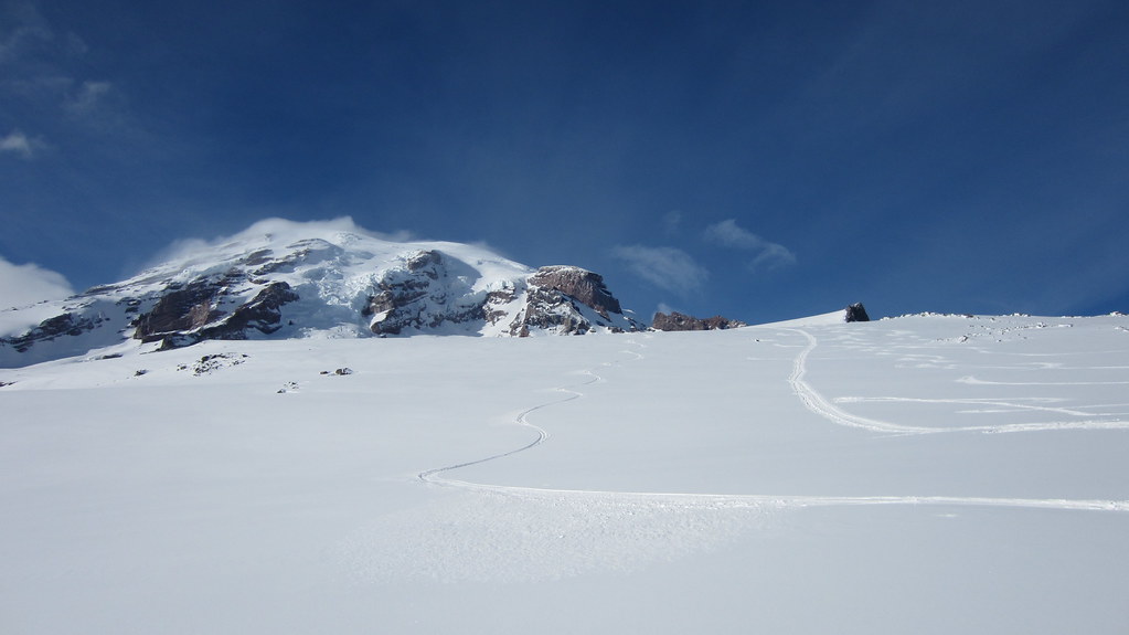
Yeah as far as the snow quality I had: From Muir down to roughly 8500, it was kind of ... variable. Like I said there was new snow, but the depth varied from maybe 1 to 6 windblown inches in places, and underneath were hardpack sastrugi, etc... so there were many times I was thrown off guard.
From maybe 8500' down to the top of Pan Point it was awesome.
And below that, it wasn't too bad either, but was of course chopped up by a zillion snowshoe/ski tracks.
No, I was wondering if anyone knows how to read a forecast and predict where the cloud tops will be.
Reply to this TR
Please login first: