Feb 6, 2012, Rainier, Muir, Nisqually Chute Sunset
2/6/12
WA Cascades West Slopes South (Mt Rainier)
8081
2
February 6, 2012, Mt Rainier, Muir + Nisqually Chute: Sunset, Moonrise, and Crazy East Winds
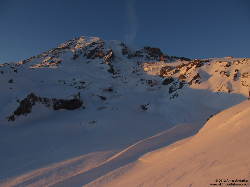
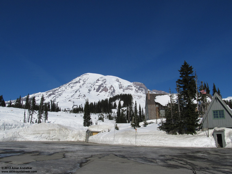
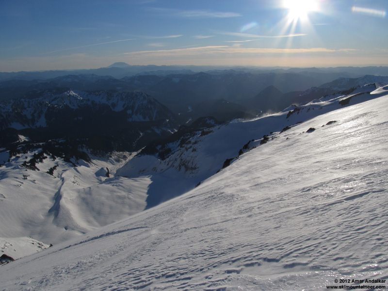
Another sunset ski descent, I think I've become addicted to that idea this winter. And a bonus moonrise on this Monday too, as the near-full moon would be rising around 4:30pm before sunset around 5:15pm. Planning for all that, I got a very leisurely start, skinning up from Paradise around 12:30pm.
The weather this day seemed almost identical to Friday the 3rd (when I had also skied to Muir, after abandoning the thought of trying a summit ski solo on Friday-Saturday). Once again it was totally sunny but with a strong easterly breeze even in the Paradise parking lot, which grew to an annoyingly strong 30-40 mph atop Panorama Point and along the ridge above. But I expected and knew that it would be much calmer higher up towards Camp Muir, as it had been on Friday. That day and this time, the UW model predicted high winds at Paradise and other locations near the Cascade Crest due to strong easterly flow caused by a large east-west pressure gradient across the Crest, but very light southerly winds at 10000 ft, and morning telemetry from Crystal, Paradise, and Camp Muir confirmed those predictions.
Flag flapping in the strong easterly breeze at Paradise.
Lots of firm icy rain crust atop Pan Point which made ski crampons very useful (as usual), and large patches of the icy crust continued along the ridge above. Once again, I travelled via Pebble Creek instead of the winter route, this time to avoid as much of the easterly wind as possible (the winter route does now have enough snow cover to skin and ski, unlike in mid-January before the major snowstorms). Large portions of our skin track from Friday were still visible through the Pebble Creek rolls and on up the windpacked powder of the Muir Snowfield to about 9000 ft, the lighter winds up here had not managed to obscure it. A few skiers were still skiing down the Snowfield at times throughout the afternoon.
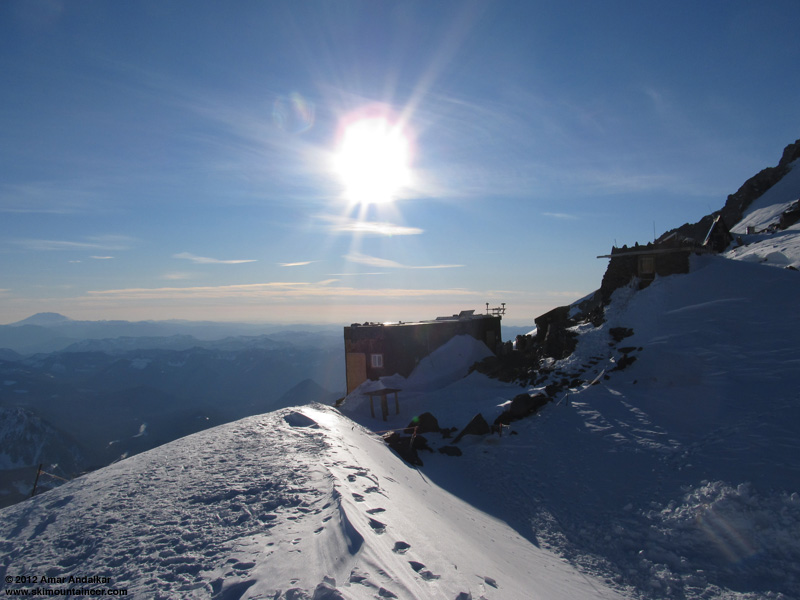
Passed a large RMI winter seminar group slowly ascending the Snowfield, and arrived at Camp Muir a bit before 4pm to find it deserted, as the lone RMI guide who was there had to quickly ski down to assist a woman in the seminar group. It was unexpected to see the camp and public shelter so empty, given that it had so busy all weekend, with almost 3 dozen climbers and skiers ascending the Gib Ledges and Ingraham Direct routes from Friday through Monday.
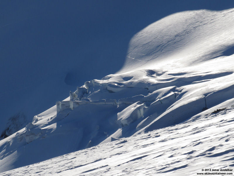
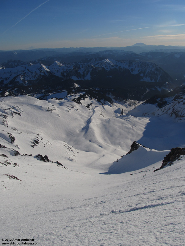
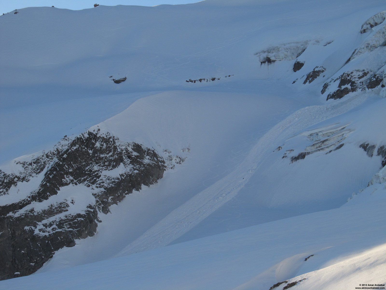
Seracs on the Nisqually Glacier, ski tracks beyond on the Wilson Glacier.
Skied down at 4:15pm, and just as on Friday, it was pretty good windpacked snow if you stayed to skier's right and followed the smooth patches between fields of sastrugi. If anything it seemed to be slightly smoother overall this day, the skiing was really quite good below 9200 ft. I was planning to ski Nisqually Chute, hoping beyond hope that the strong sunshine and freezing level near 10000 ft (according to the UW model and NWAC forecast, although lower on the NWS Rainier forecast) might be enough to soften it to corn. But I realized that even though the Chute faces SW, the strong easterly winds might flow across that slope enough prevent softening, and since the same winds had persisted on Friday-Saturday, it might also have prevented the multiple melt-freeze cycles needed to produce corn snow. On the way up, a few faint ski tracks were visible in the Chute, but gave no clue as to when they might have been made or on what snow conditions.
The rollover at the entrance was still hard-frozen snow with patches of ice, with the gusty east wind blowing across -- not a good sign, but it seemed worth a try. Dropped into the Chute at 4:30pm, still plenty of sunshine and the shadows were just starting to creep across the right edge of the Chute.
A partially-softened, partially-corned crust is the best description of the snow I can come up with. Definitely not enough melt-freeze cycles had occurred to form true corn snow, and definitely too much wind today to soften the surface as much as needed. But at least it was a supportive crust and not breakable, although I skied slowly and cautiously just in case it suddenly became breakable. Luckily it never did, and the ski down was decent enough. Not the stunning run in sweet corn that I'd enjoyed the last time I had been here, almost exactly two moons earlier on another sunset, full-moonrise evening (
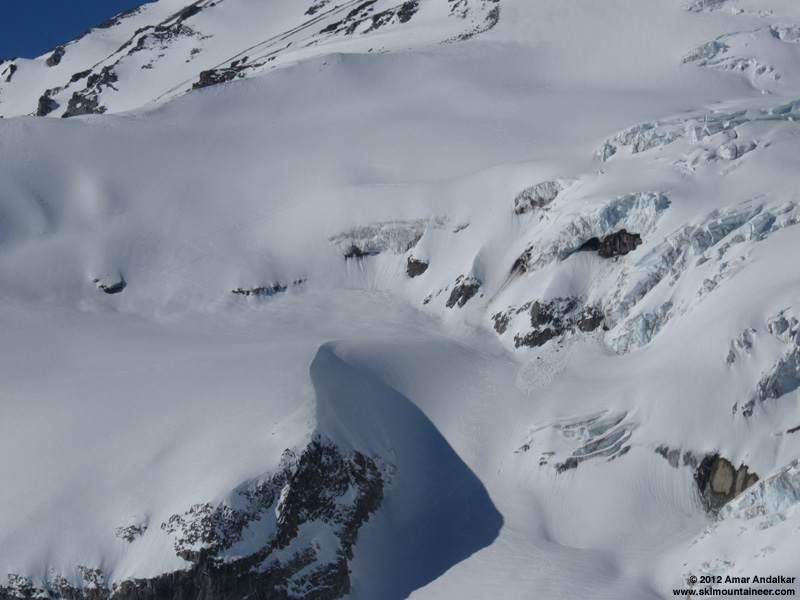
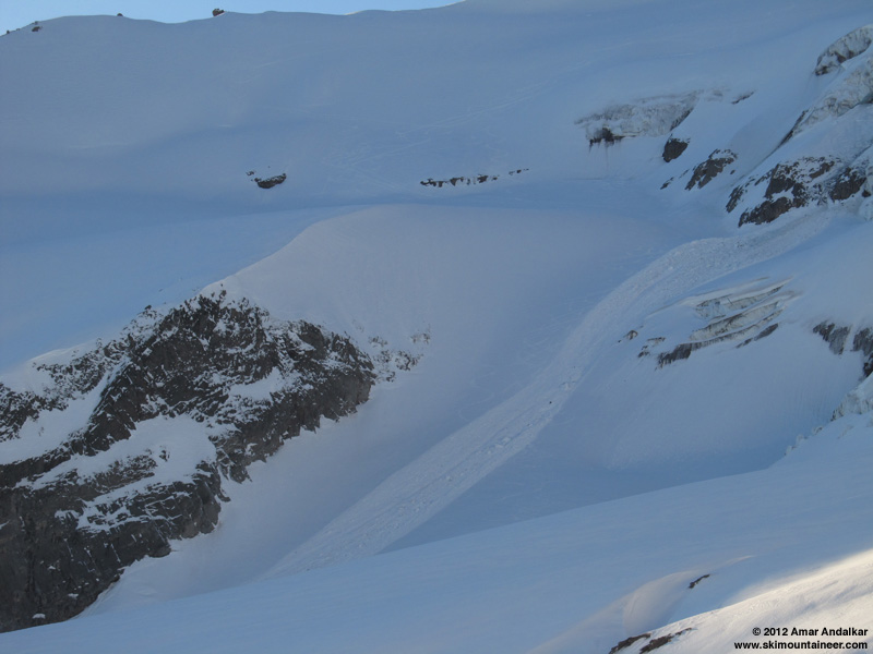
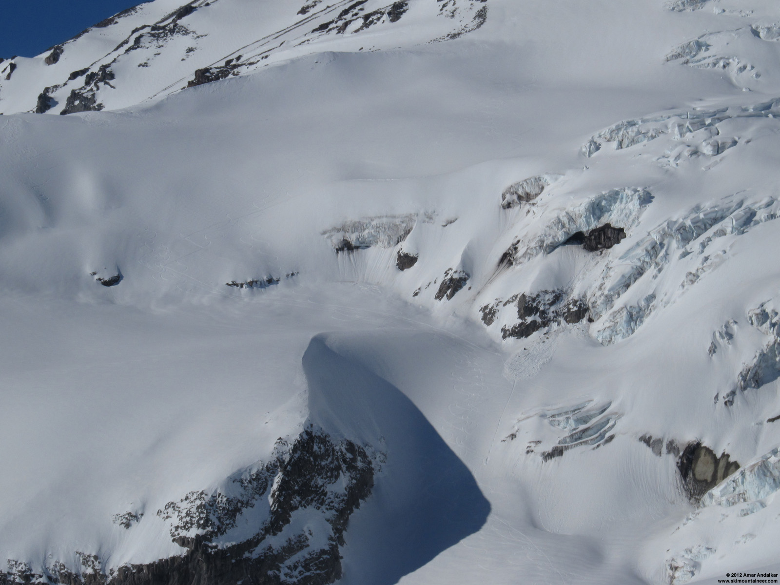
Across the Nisqually Glacier, several ski tracks (over a half-dozen) had been visible on the Wilson Glacier as I had skinned up earlier in the day, from parties heading for Fuhrer Finger and other destinations over the weekend. It was now apparent that a LARGE serac-fall avalanche had occurred on the lower Wilson Glacier sometime in the last 2 hours, which wiped out the ski tracks (plus the entire skin track) in that bowl between the cliffs. That route has looked so dangerous this year with the menacing ice cliff above it, as the ice cliff there has changed a lot from previous years and I've been expecting it to cause trouble this year. If that had come down while anyone was skinning up that track -- no chance of survival. Even if it happened while someone was skiing down, it would have been a pretty bad scene. The standard climbers' route via the "Fan" is not as good a ski route to get to the same spots (it's too flat and up-down across the Nisqually), but certainly looks to be a lot safer this year.
(click for double-size version)
Before, 2pm: ski tracks on the Wilson Glacier, with debris from a small serac-fall avalanche nearby.
(click for double-size version)
After, 4:30pm: debris from a large serac-fall avalanche wipes out a large portion of skin track and ski tracks.
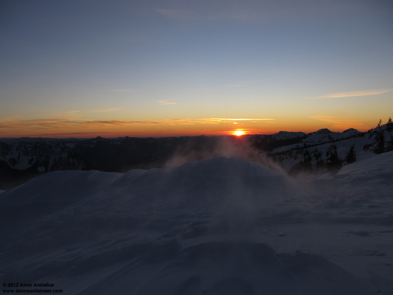
The skin back out to Glacier Vista promised to be quite a different experience this time than in December too -- the strong wind was just ripping across and down the slope, blowing and drifting snow into the existing skintrack. The combination of the sun setting and the snow blowing as I slowly skinned across the southwest-facing slope was quite fascinating.
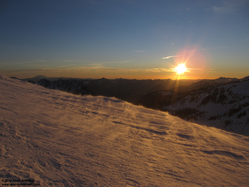
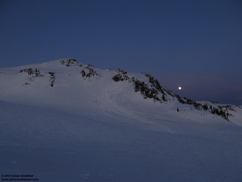
Topped out at Glacier Vista in a blasting 40-50 mph wind right at sunset, then dropped into a small hollow to be able to de-skin. Simultaneously, the near-full moon was already rising beside Panorama Point to the east. A spectacular scene.
I hoped for a quick twilight cruise back to Paradise to end the day, but the breakable zipper crust in many places below 5800 ft required slow and cautious travel on the last portion. Still back just before dark, skiing out to the edge of the treacherous ice in the middle of the parking lot near my car, to avoid having to walk across it. Just another fine day on the Mountain.
[hr][tt]MOUNT RAINIER RECREATIONAL FORECAST
NATIONAL WEATHER SERVICE SEATTLE WA
400 AM PST MON FEB 6 2012
SYNOPSIS...AN UPPER RIDGE WILL KEEP THE WEATHER DRY THROUGH TUESDAY. A WEAK FRONT COULD BRING A LITTLE PRECIPITATION TO MOUNT RAINIER NATIONAL PARK TUESDAY NIGHT OR WEDNESDAY. A TRANSITION TO A MORE TYPICALLY ACTIVE WINTER PATTERN IS LIKELY FRIDAY THROUGH THE WEEKEND.
MONDAY...SUNNY. FREEZING LEVEL 7500 FEET.
MONDAY NIGHT...MOSTLY CLEAR. FREEZING LEVEL 8000 FEET.
TUESDAY...MOSTLY SUNNY. FREEZING LEVEL 7000 FEET.
TUESDAY NIGHT...MOSTLY CLOUDY. FREEZING LEVEL 5500 FEET.
WEDNESDAY...MOSTLY CLOUDY WITH A CHANCE OF SNOW AND RAIN. SNOW LEVEL 4500 FEET.
TEMPERATURE AND WIND FORECASTS FOR SELECTED LOCATIONS.
            MON  MON  TUE  TUE  WEDÂ
              NIGHT     NIGHT   Â
SUMMITÂ Â (14411 FT)Â Â Â 11Â Â Â 11Â Â Â 10Â Â Â 7Â Â Â 6
           S 15  S 20  S 25 SW 25  W 50
CAMP MUIR(10188 FT)Â Â Â 30Â Â Â 32Â Â Â 25Â Â Â 20Â Â Â 20
           S 15  S 20  S 20 SW 25  W 40
PARADISEÂ (5420 FT)Â Â Â 42Â Â Â 26Â Â Â 36Â Â Â 28Â Â Â 41
           NE 15 NE 15 NE 10  W 5 SW 15
LONGMIREÂ (2700 FT)Â Â Â 41Â Â Â 28Â Â Â 38Â Â Â 30Â Â Â 41
           E 15 NE 15 NE 10  N 5 SW 10
++ TEMPERATURES AND WIND FOR THE SUMMIT AND CAMP MUIR ARE AVERAGE
  CONDITIONS EXPECTED IN THE FREE AIR AT THOSE ELEVATIONS.
++ TEMPERATURES FOR PARADISE AND LONGMIRE ARE THE EXPECTED HIGHS AND
  LOWS. WIND IS THE AVERAGE WIND EXPECTED DURING THAT PERIOD.
EXTENDED FORECAST...
WEDNESDAY NIGHT...MOSTLY CLOUDY WITH A CHANCE OF RAIN AND SNOW. SNOW LEVEL 5500 FEET.
THURSDAY...PARTLY SUNNY. FREEZING LEVEL 6500 FEET.
THURSDAY NIGHT...MOSTLY CLOUDY. FREEZING LEVEL 8500 FEET.
FRIDAY...MOSTLY CLOUDY WITH A CHANCE OF RAIN AND SNOW. SNOW LEVEL 7000 FEET.
FRIDAY NIGHT...MOSTLY CLOUDY WITH A CHANCE OF RAIN AND SNOW. SNOW LEVEL 5500 FEET.
SATURDAY...MOSTLY CLOUDY WITH A CHANCE OF SNOW AND RAIN. SNOW LEVEL 4500 FEET.
SATURDAY NIGHT...MOSTLY CLOUDY WITH A CHANCE OF RAIN AND SNOW. SNOW LEVEL 5000 FEET.
SUNDAY...SNOW AND RAIN LIKELY. SNOW LEVEL 4000 FEET.
[/tt]
Another sunset ski descent, I think I've become addicted to that idea this winter. And a bonus moonrise on this Monday too, as the near-full moon would be rising around 4:30pm before sunset around 5:15pm. Planning for all that, I got a very leisurely start, skinning up from Paradise around 12:30pm.
The weather this day seemed almost identical to Friday the 3rd (when I had also skied to Muir, after abandoning the thought of trying a summit ski solo on Friday-Saturday). Once again it was totally sunny but with a strong easterly breeze even in the Paradise parking lot, which grew to an annoyingly strong 30-40 mph atop Panorama Point and along the ridge above. But I expected and knew that it would be much calmer higher up towards Camp Muir, as it had been on Friday. That day and this time, the UW model predicted high winds at Paradise and other locations near the Cascade Crest due to strong easterly flow caused by a large east-west pressure gradient across the Crest, but very light southerly winds at 10000 ft, and morning telemetry from Crystal, Paradise, and Camp Muir confirmed those predictions.
Flag flapping in the strong easterly breeze at Paradise.
Lots of firm icy rain crust atop Pan Point which made ski crampons very useful (as usual), and large patches of the icy crust continued along the ridge above. Once again, I travelled via Pebble Creek instead of the winter route, this time to avoid as much of the easterly wind as possible (the winter route does now have enough snow cover to skin and ski, unlike in mid-January before the major snowstorms). Large portions of our skin track from Friday were still visible through the Pebble Creek rolls and on up the windpacked powder of the Muir Snowfield to about 9000 ft, the lighter winds up here had not managed to obscure it. A few skiers were still skiing down the Snowfield at times throughout the afternoon.
Passed a large RMI winter seminar group slowly ascending the Snowfield, and arrived at Camp Muir a bit before 4pm to find it deserted, as the lone RMI guide who was there had to quickly ski down to assist a woman in the seminar group. It was unexpected to see the camp and public shelter so empty, given that it had so busy all weekend, with almost 3 dozen climbers and skiers ascending the Gib Ledges and Ingraham Direct routes from Friday through Monday.
Seracs on the Nisqually Glacier, ski tracks beyond on the Wilson Glacier.
Skied down at 4:15pm, and just as on Friday, it was pretty good windpacked snow if you stayed to skier's right and followed the smooth patches between fields of sastrugi. If anything it seemed to be slightly smoother overall this day, the skiing was really quite good below 9200 ft. I was planning to ski Nisqually Chute, hoping beyond hope that the strong sunshine and freezing level near 10000 ft (according to the UW model and NWAC forecast, although lower on the NWS Rainier forecast) might be enough to soften it to corn. But I realized that even though the Chute faces SW, the strong easterly winds might flow across that slope enough prevent softening, and since the same winds had persisted on Friday-Saturday, it might also have prevented the multiple melt-freeze cycles needed to produce corn snow. On the way up, a few faint ski tracks were visible in the Chute, but gave no clue as to when they might have been made or on what snow conditions.
The rollover at the entrance was still hard-frozen snow with patches of ice, with the gusty east wind blowing across -- not a good sign, but it seemed worth a try. Dropped into the Chute at 4:30pm, still plenty of sunshine and the shadows were just starting to creep across the right edge of the Chute.
A partially-softened, partially-corned crust is the best description of the snow I can come up with. Definitely not enough melt-freeze cycles had occurred to form true corn snow, and definitely too much wind today to soften the surface as much as needed. But at least it was a supportive crust and not breakable, although I skied slowly and cautiously just in case it suddenly became breakable. Luckily it never did, and the ski down was decent enough. Not the stunning run in sweet corn that I'd enjoyed the last time I had been here, almost exactly two moons earlier on another sunset, full-moonrise evening (
Across the Nisqually Glacier, several ski tracks (over a half-dozen) had been visible on the Wilson Glacier as I had skinned up earlier in the day, from parties heading for Fuhrer Finger and other destinations over the weekend. It was now apparent that a LARGE serac-fall avalanche had occurred on the lower Wilson Glacier sometime in the last 2 hours, which wiped out the ski tracks (plus the entire skin track) in that bowl between the cliffs. That route has looked so dangerous this year with the menacing ice cliff above it, as the ice cliff there has changed a lot from previous years and I've been expecting it to cause trouble this year. If that had come down while anyone was skinning up that track -- no chance of survival. Even if it happened while someone was skiing down, it would have been a pretty bad scene. The standard climbers' route via the "Fan" is not as good a ski route to get to the same spots (it's too flat and up-down across the Nisqually), but certainly looks to be a lot safer this year.
(click for double-size version)
Before, 2pm: ski tracks on the Wilson Glacier, with debris from a small serac-fall avalanche nearby.
(click for double-size version)
After, 4:30pm: debris from a large serac-fall avalanche wipes out a large portion of skin track and ski tracks.
The skin back out to Glacier Vista promised to be quite a different experience this time than in December too -- the strong wind was just ripping across and down the slope, blowing and drifting snow into the existing skintrack. The combination of the sun setting and the snow blowing as I slowly skinned across the southwest-facing slope was quite fascinating.
Topped out at Glacier Vista in a blasting 40-50 mph wind right at sunset, then dropped into a small hollow to be able to de-skin. Simultaneously, the near-full moon was already rising beside Panorama Point to the east. A spectacular scene.
I hoped for a quick twilight cruise back to Paradise to end the day, but the breakable zipper crust in many places below 5800 ft required slow and cautious travel on the last portion. Still back just before dark, skiing out to the edge of the treacherous ice in the middle of the parking lot near my car, to avoid having to walk across it. Just another fine day on the Mountain.
[hr][tt]MOUNT RAINIER RECREATIONAL FORECAST
NATIONAL WEATHER SERVICE SEATTLE WA
400 AM PST MON FEB 6 2012
SYNOPSIS...AN UPPER RIDGE WILL KEEP THE WEATHER DRY THROUGH TUESDAY. A WEAK FRONT COULD BRING A LITTLE PRECIPITATION TO MOUNT RAINIER NATIONAL PARK TUESDAY NIGHT OR WEDNESDAY. A TRANSITION TO A MORE TYPICALLY ACTIVE WINTER PATTERN IS LIKELY FRIDAY THROUGH THE WEEKEND.
MONDAY...SUNNY. FREEZING LEVEL 7500 FEET.
MONDAY NIGHT...MOSTLY CLEAR. FREEZING LEVEL 8000 FEET.
TUESDAY...MOSTLY SUNNY. FREEZING LEVEL 7000 FEET.
TUESDAY NIGHT...MOSTLY CLOUDY. FREEZING LEVEL 5500 FEET.
WEDNESDAY...MOSTLY CLOUDY WITH A CHANCE OF SNOW AND RAIN. SNOW LEVEL 4500 FEET.
TEMPERATURE AND WIND FORECASTS FOR SELECTED LOCATIONS.
            MON  MON  TUE  TUE  WEDÂ
              NIGHT     NIGHT   Â
SUMMITÂ Â (14411 FT)Â Â Â 11Â Â Â 11Â Â Â 10Â Â Â 7Â Â Â 6
           S 15  S 20  S 25 SW 25  W 50
CAMP MUIR(10188 FT)Â Â Â 30Â Â Â 32Â Â Â 25Â Â Â 20Â Â Â 20
           S 15  S 20  S 20 SW 25  W 40
PARADISEÂ (5420 FT)Â Â Â 42Â Â Â 26Â Â Â 36Â Â Â 28Â Â Â 41
           NE 15 NE 15 NE 10  W 5 SW 15
LONGMIREÂ (2700 FT)Â Â Â 41Â Â Â 28Â Â Â 38Â Â Â 30Â Â Â 41
           E 15 NE 15 NE 10  N 5 SW 10
++ TEMPERATURES AND WIND FOR THE SUMMIT AND CAMP MUIR ARE AVERAGE
  CONDITIONS EXPECTED IN THE FREE AIR AT THOSE ELEVATIONS.
++ TEMPERATURES FOR PARADISE AND LONGMIRE ARE THE EXPECTED HIGHS AND
  LOWS. WIND IS THE AVERAGE WIND EXPECTED DURING THAT PERIOD.
EXTENDED FORECAST...
WEDNESDAY NIGHT...MOSTLY CLOUDY WITH A CHANCE OF RAIN AND SNOW. SNOW LEVEL 5500 FEET.
THURSDAY...PARTLY SUNNY. FREEZING LEVEL 6500 FEET.
THURSDAY NIGHT...MOSTLY CLOUDY. FREEZING LEVEL 8500 FEET.
FRIDAY...MOSTLY CLOUDY WITH A CHANCE OF RAIN AND SNOW. SNOW LEVEL 7000 FEET.
FRIDAY NIGHT...MOSTLY CLOUDY WITH A CHANCE OF RAIN AND SNOW. SNOW LEVEL 5500 FEET.
SATURDAY...MOSTLY CLOUDY WITH A CHANCE OF SNOW AND RAIN. SNOW LEVEL 4500 FEET.
SATURDAY NIGHT...MOSTLY CLOUDY WITH A CHANCE OF RAIN AND SNOW. SNOW LEVEL 5000 FEET.
SUNDAY...SNOW AND RAIN LIKELY. SNOW LEVEL 4000 FEET.
[/tt]
nice pix amar .. esp of the blowing snow
Nice report, as usual, Amar. It made for a nice lunchtime read today.
Thank you for capturing these largely unseen marvels on the mountain (the blowing snow back-dropped by a beautiful sunset and the serac fall/avalanche on the Wilson Glacier).
I wish I could be out there more with you instead of sitting at my desk job.
Thank you for capturing these largely unseen marvels on the mountain (the blowing snow back-dropped by a beautiful sunset and the serac fall/avalanche on the Wilson Glacier).
I wish I could be out there more with you instead of sitting at my desk job.
Reply to this TR
Please login first: