August 4-8, 2011, ONP, Mt Carrie - Mt Ruth
8/4/11
WA Olympics
6851
10
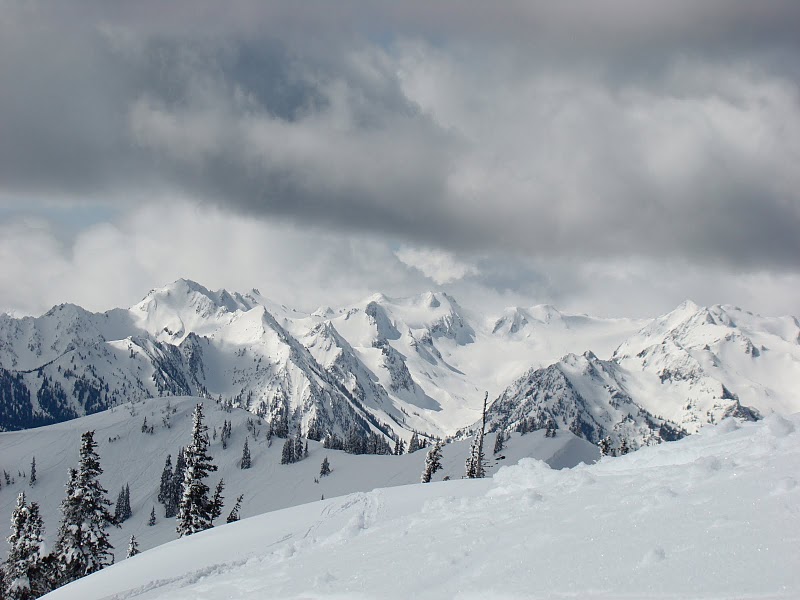
Rounding the last corner to Hurricane Ridge, you are greeted by views of the northern Bailey Range. This area includes Mt. Carrie, Mt. Fairchild, Mt. Fitzhenry, Mt Ruth and the Carrie and Fairchild glaciers. Just to the south is Stephan Peak. For years I have looked for the right opportunity to make a ski trip into this area. This years fat snowpack and slow melt out provided just the right mix of conditions to entice Snow Bell, TBill and me to attempt a trip into this area.
I was limited to a 4 day window at the end of the first week of August, fortunately the weather cooperated. Due to a combination of road closures and trail washouts in the Elwha, it was not possible to do the classic traverse from the Sol Duc to Dodger Point. We would have to make an out and back trip starting from the Sol Duc. Our goal was to ski as much of this area as possible.
Day 1: Sol Duc to Cat Peak
The price of admission to much of the Olympic alpine comes at a pretty high price. This trip would be no exception. Before reaching the summit of Mt. Carrie, our first ski descent, we would travel over 11 miles both on and off trail and climb about 5,000 vf.
Our trip began at the Sol Duc trailhead. We followed the trail to Heart Lake, the most direct route to Seven Lakes Basin. We hit patchy snow at about 4,200. Shortly after this, a cool barefoot stream crossing in Sol Duc Park refreshed our tiring feet. Continuous snow started just below Heart Lake. The lake was still almost completely frozen over. Joe elected to start skinning. Just past the High Divided we met two young women who had spent the previous night at Swimming Bear Lake in Cat Basin. Their tracks simplified our route finding through this section. Once we reached the low saddle separating Seven Lakes Basin from Cat Peak we found ever increasing sections of snow free trail. At Cat Peak we elected to camp at the last decent bivy spot before the Catwalk.
Day 2: Cat Peak to the Fairchild Glacier
While planning this trip, the section of trail from Cat Peak to the Catwalk presented some concerns. It was chiseled out of the steep western flank of the Mountain in the 1930s. It traverses several steep gulleys. Had this not been melted out, it would have been difficult to stay on route. Being too high or low could have made travel difficult, if not impossible. Fortunately it was snow free.
This trail ends at an impassable gulley. A short steep scramble up the slope brought us to the start of the Catwalk. This is U-shaped arete separates Cat Peak from Mt Carrie and the start of the Bailey Range. The scramble across it did not prove to be as difficult as expected with skis and boots on our backs. The goat hair clinging the trees and bushes helped us navigate the route.
After a short break at Boston Charlies, we started the 2,000 climb to the summit of Mt Carrie. About half way up, we ran into a herd of about 20 mountain goats. They scampered down the slope to greet us. With his white hat and bushy beard, they may have mistaken Trevor for a long lost relative. After a short visit, each group continued on our respective journeys.
The summit of Carrie was a welcome site. At just under 7,000, it is the highest point in the Bailey Range. We were excited to finally get our skis (and board) off our backs and on our feet! Trevor did not want to carry snowboard boots, so he came up with an ingenious way to adapt his climbing boots to his board. A couple of the pictures document his injenuity. We descended through rolling terrain for about 2,000 on great corn snow. We had spotted a lake from the summit of Carrie that looked to be an excellent campsite for night 2. A couple hundred vf before reaching it, we found running water and a large patch of dry ground. We elected to camp here instead. After dropping our overnight gear we headed off to get some evening turns and scout the route to Stephan Peak. Although we didnt find the col we were looking for, we did find some more great turns in the evening sun.
Day 3: Mt Ruth and the Return to Cat Peak
After an early breakfast, we evaluated several options, finally deciding to head for Mt Ruth. This peak is south of the Fairchild Glacier and separates this drainage from Stephan Peak basin, further to the south. This would also give us the opportunity to find the col leading to Stephan.
The route to the top of Ruth involves climbing two rather steep pitches separated by a large basin. The first pitch is a glaciated section. The climbers left side of this was crevassed glacial ice. Fortunately, the right side still had good snow cover sufficiently wide for a ski descent. At the top of this section, we took a short break. Joe and Trevor booted over to the ridge line and confirmed the col we spied was the route leading to Stephan. Unfortunately, we did not have enough time to make the trek to this beautiful area. A second steep snowfield brought us to near the summit of Ruth. Trevor scrambled up the summit block, Joe and I cheered him on.
The ski descent was exhilarating (for me anyway!). I got a bit close to the ice on the lower steep section, lost my edges and went for a bit of a ride. My Whippet did an excellent job of helping me arrest the slide. It was the first time I had used it to stop a fall.
Once back down, we gathered up our camping gear and skinned back to the summit of Carrie. Joe and Trevor elected to ski the Carrie Glacier. I took advantage of the time to melt water for the group and enjoy the views. After their return, we skied the upper snowfield on Carrie and headed over to the ridge line. The day before, we had spotted several snow fields on the NW side of Carrie we hoped would allow us to ski into the basin west of the Catwalk and bypass it altogether on our return. Unfortunately, clouds rolling up the slope from a persistent marine layer in the Hoh River valley foiled our efforts to identify a viable route. Finding a brief break in the clouds, we make some turns down one of the slopes. After a short carry and some more scouting we did find what we were looking for. Although the snowfield did not go all the way to the bottom of the basin, it got us close enough. As we descended this route, we found a short snow covered slope we could climb which would take us back to the Cat Peak end of the Catwalk. We hiked back to our first nights campsite as night fell.
Day 4: Cat Peak to Sol Duc
We retraced our route back to the High Divide and continued along the divide to the ridge separating the Heart Lake Basin from the main Seven Lakes Basin. The main basin was still almost completely snow covered and most of the lakes were still either partially or completely frozen over. From here we were able to ski down to Heart Lake. At this point, skis and boots went back on our packs and we started the 3 hour hike back out to the trailhead.
Here are a couple pictures from our trip;
1. The Northern Baileys
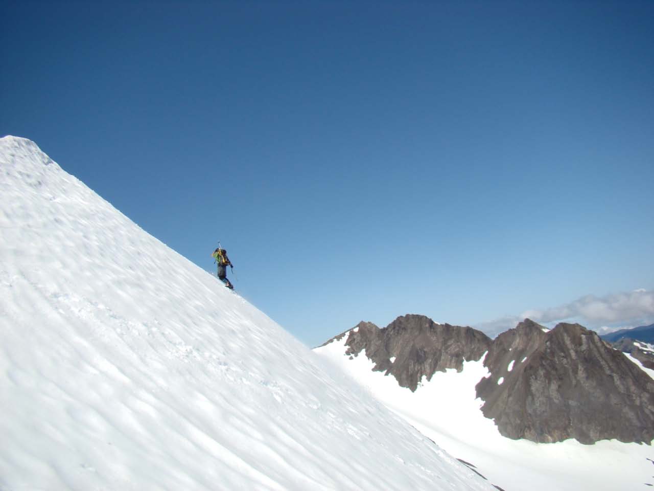
2. Joe with Ruth in the Background
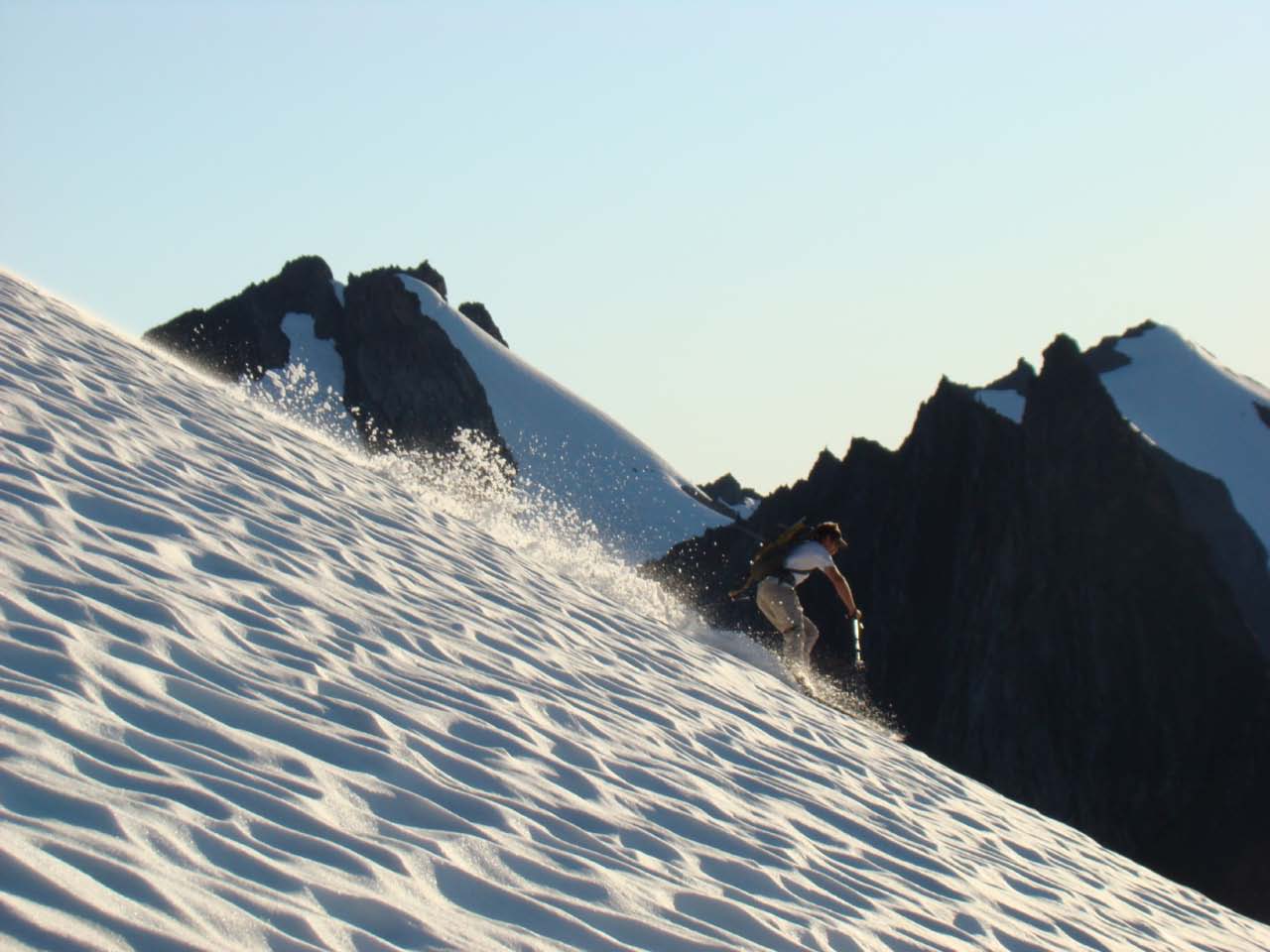
3. Trevor descending from the summit of Ruth
Here is a link to a few more; https://picasaweb.google.com/GaryJanH/20110848BaileyRange
Gary
I was limited to a 4 day window at the end of the first week of August, fortunately the weather cooperated. Due to a combination of road closures and trail washouts in the Elwha, it was not possible to do the classic traverse from the Sol Duc to Dodger Point. We would have to make an out and back trip starting from the Sol Duc. Our goal was to ski as much of this area as possible.
Day 1: Sol Duc to Cat Peak
The price of admission to much of the Olympic alpine comes at a pretty high price. This trip would be no exception. Before reaching the summit of Mt. Carrie, our first ski descent, we would travel over 11 miles both on and off trail and climb about 5,000 vf.
Our trip began at the Sol Duc trailhead. We followed the trail to Heart Lake, the most direct route to Seven Lakes Basin. We hit patchy snow at about 4,200. Shortly after this, a cool barefoot stream crossing in Sol Duc Park refreshed our tiring feet. Continuous snow started just below Heart Lake. The lake was still almost completely frozen over. Joe elected to start skinning. Just past the High Divided we met two young women who had spent the previous night at Swimming Bear Lake in Cat Basin. Their tracks simplified our route finding through this section. Once we reached the low saddle separating Seven Lakes Basin from Cat Peak we found ever increasing sections of snow free trail. At Cat Peak we elected to camp at the last decent bivy spot before the Catwalk.
Day 2: Cat Peak to the Fairchild Glacier
While planning this trip, the section of trail from Cat Peak to the Catwalk presented some concerns. It was chiseled out of the steep western flank of the Mountain in the 1930s. It traverses several steep gulleys. Had this not been melted out, it would have been difficult to stay on route. Being too high or low could have made travel difficult, if not impossible. Fortunately it was snow free.
This trail ends at an impassable gulley. A short steep scramble up the slope brought us to the start of the Catwalk. This is U-shaped arete separates Cat Peak from Mt Carrie and the start of the Bailey Range. The scramble across it did not prove to be as difficult as expected with skis and boots on our backs. The goat hair clinging the trees and bushes helped us navigate the route.
After a short break at Boston Charlies, we started the 2,000 climb to the summit of Mt Carrie. About half way up, we ran into a herd of about 20 mountain goats. They scampered down the slope to greet us. With his white hat and bushy beard, they may have mistaken Trevor for a long lost relative. After a short visit, each group continued on our respective journeys.
The summit of Carrie was a welcome site. At just under 7,000, it is the highest point in the Bailey Range. We were excited to finally get our skis (and board) off our backs and on our feet! Trevor did not want to carry snowboard boots, so he came up with an ingenious way to adapt his climbing boots to his board. A couple of the pictures document his injenuity. We descended through rolling terrain for about 2,000 on great corn snow. We had spotted a lake from the summit of Carrie that looked to be an excellent campsite for night 2. A couple hundred vf before reaching it, we found running water and a large patch of dry ground. We elected to camp here instead. After dropping our overnight gear we headed off to get some evening turns and scout the route to Stephan Peak. Although we didnt find the col we were looking for, we did find some more great turns in the evening sun.
Day 3: Mt Ruth and the Return to Cat Peak
After an early breakfast, we evaluated several options, finally deciding to head for Mt Ruth. This peak is south of the Fairchild Glacier and separates this drainage from Stephan Peak basin, further to the south. This would also give us the opportunity to find the col leading to Stephan.
The route to the top of Ruth involves climbing two rather steep pitches separated by a large basin. The first pitch is a glaciated section. The climbers left side of this was crevassed glacial ice. Fortunately, the right side still had good snow cover sufficiently wide for a ski descent. At the top of this section, we took a short break. Joe and Trevor booted over to the ridge line and confirmed the col we spied was the route leading to Stephan. Unfortunately, we did not have enough time to make the trek to this beautiful area. A second steep snowfield brought us to near the summit of Ruth. Trevor scrambled up the summit block, Joe and I cheered him on.
The ski descent was exhilarating (for me anyway!). I got a bit close to the ice on the lower steep section, lost my edges and went for a bit of a ride. My Whippet did an excellent job of helping me arrest the slide. It was the first time I had used it to stop a fall.
Once back down, we gathered up our camping gear and skinned back to the summit of Carrie. Joe and Trevor elected to ski the Carrie Glacier. I took advantage of the time to melt water for the group and enjoy the views. After their return, we skied the upper snowfield on Carrie and headed over to the ridge line. The day before, we had spotted several snow fields on the NW side of Carrie we hoped would allow us to ski into the basin west of the Catwalk and bypass it altogether on our return. Unfortunately, clouds rolling up the slope from a persistent marine layer in the Hoh River valley foiled our efforts to identify a viable route. Finding a brief break in the clouds, we make some turns down one of the slopes. After a short carry and some more scouting we did find what we were looking for. Although the snowfield did not go all the way to the bottom of the basin, it got us close enough. As we descended this route, we found a short snow covered slope we could climb which would take us back to the Cat Peak end of the Catwalk. We hiked back to our first nights campsite as night fell.
Day 4: Cat Peak to Sol Duc
We retraced our route back to the High Divide and continued along the divide to the ridge separating the Heart Lake Basin from the main Seven Lakes Basin. The main basin was still almost completely snow covered and most of the lakes were still either partially or completely frozen over. From here we were able to ski down to Heart Lake. At this point, skis and boots went back on our packs and we started the 3 hour hike back out to the trailhead.
Here are a couple pictures from our trip;
1. The Northern Baileys
2. Joe with Ruth in the Background
3. Trevor descending from the summit of Ruth
Here is a link to a few more; https://picasaweb.google.com/GaryJanH/20110848BaileyRange
Gary
Beautiful!!!
What an adventurous tour for August! Love it!
Would like to hear Trevor's writeup of how well that tongue-out snowboard binding trick worked. As good as, or better than, using 3 buckle AT boots as far as the feel?
Would like to hear Trevor's writeup of how well that tongue-out snowboard binding trick worked. As good as, or better than, using 3 buckle AT boots as far as the feel?
Inspiring trip! What a beautiful tour. I really enjoyed all the photos on Picassa.
DH
DH
This TR was worth the wait!
I'm guessing the first photo was taken a bit before August???
I'm guessing the first photo was taken a bit before August???
Gorgeous! It looks like April! Always wanted to ski that area, it's so remote and such an enticing traverse.
author=telemack link=topic=21719.msg93073#msg93073 date=1315153169]
I'm guessing the first photo was taken a bit before August???
You guessed right Mac, it was taken this spring on a day tour to the Ridge. I thought it best captures the beauty of this area.
Thanks to others for comments to the post .............
Gary
author=wolfs link=topic=21719.msg93038#msg93038 date=1314999261]
What an adventurous tour for August! Love it!
Would like to hear Trevor's writeup of how well that tongue-out snowboard binding trick worked. As good as, or better than, using 3 buckle AT boots as far as the feel?
The system that incorporated the AT boot tongue and ski strap felt a little stiff for my liking after giving it a go a couple runs. I simplified it down to just wrapping a ski strap around the highback and my high ankle for the remainder of the trip providing lateral support. It still took some getting used to (along with riding with highbacks again) but I felt it was adequate for the amount of hiking vs riding involved. The boot filt snug in the binding without any sloppy play while riding.
I haven't ridden with hard boots before so I can't offer a comparison.
The little skinning I did was commical when trying to side hill traverse.
Wow that first photo is amazing and congrats guys that area is stunning!
Awesome trip and report! I'm reading the biography of Herb and Lois Crisler, "Beyond the Trails", which chronicles many early trips in this area. He'd be proud of you guys!
Ha! I just saw this. Good write up Gary. It conjures fond memories of a great trip.
Thanks again fellas.
Thanks again fellas.
Reply to this TR
Please login first: