July 1-5, 2011, Dakobed Traverse and Glacier Peak
7/1/11
WA Cascades West Slopes Central
7294
13
Glacier Peak has been my favorite place in the Cascades for over 30 years. Two memorable backpacking trips in my college years had taken me from Rainy Pass to Kennedy Hot Springs (may it return some day) and from the North Fork of the Sauk to Stehekin. After a long absence, I was able to return during Feb of 2010 in an unsuccessful attempt of Glacier Peak.
http://www.turns-all-year.com/skiing_snowboarding/trip_reports/index.php?topic=15742.0
Although we didn't reach the summit, I was glad for the excuse to return to the land of high alpine scenery, rugged peaks, and endless ski terrain. Further inspiration to add the Dakobed Traverse to the trip was provided by the Skoog brothers:
http://www.turns-all-year.com/skiing_snowboarding/trip_reports/index.php?topic=13536.msg56989;topicseen#msg56989
http://www.greatoutdoors.com/blogs/gordys/20090615/skiing-the-dakobed-traverse-tools-or-toys
and the Jason Hummel and Kyle Miller trip:
http://www.turns-all-year.com/skiing_snowboarding/trip_reports/index.php?topic=13885.0
http://www.cascadecrusades.org/SkiMountaineering/glacierpeak/dakobedtraverse2009/dakobed2009.htm
(Not to mention a washout on the North Fork Sauk that added 5 road miles to the approach from that direction.)
Andrew McDavid (Andyrew) was enthusiastic for another shot at Glacier and liked the idea of the Dakobed. The late snowpack gave us hope for more skiing than hiking and the forecast looked quite nice for the 5 days with the exception of a minor disturbance during the middle day.
We left the White River Trailhead around noon on Friday after a leisurely departure. We transitioned onto skis at about 4,500 feet and set up camp at Boulder Pass. Our least favorite camp during the trip, there was no running water, not much of a view, and only a small patch of dry ground for cooking and keeping gear off the snow. Camping on the edge off the Walrus glacier would at least offer better views.
The next morning dawned clear and calm and after a leisurely breakfast we crossed over the ridge and started up the Walrus Glacier. We kept to the left hand side of the glacier to avoid most of the crevasses and seracs and found a pleasant line to the col at 8,100 on the shoulder of Clark. The skin up the south side off Clark to the summit was steep in places and made more interesting by the rapidly softening snow. The views from the summit were outstanding and the summit register indicated that one other party had reached the summit in 2011. The ski back to the col provided our first well-earned turns.
We stayed high beneath the north side of Clark to the Richardson Glacier. We debated whether to go above or below the buttress at 7,800 ft on the northwest ridge of Clark and in the end decided to go high. This route required a short ski carry, negotiating a tricky moat, and a turn or two on 50 degree snow before resuming our downward glide across the Richardson. Looking back at what we crossed indicated that the route below the buttress would have been simpler although it was steep and would have dropped us several hundred feet lower than our high route.
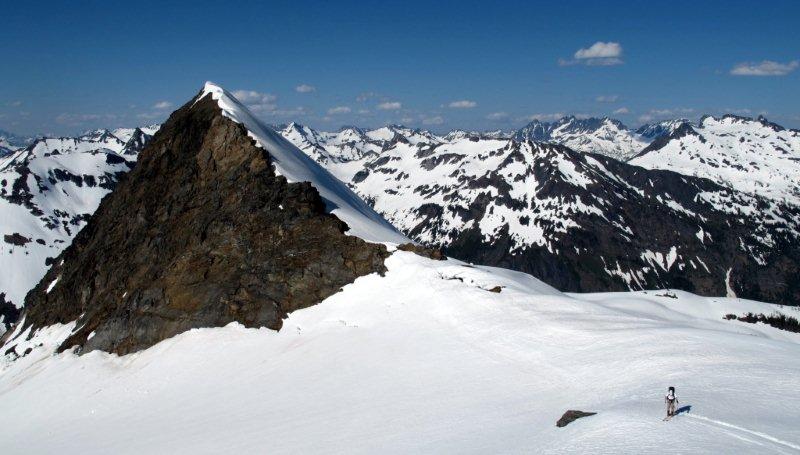
As we continued on across the Richardson we had to decide between two cols on the east ridge of Luahna, one at about 7,400 and the other at 7,900. Since climbing Luahna was one of my objectives for the trip, we went for the high col. This was also the route used by the Skoog party and it actually works out quite well although it looks steep from the other side of the Richardson. Unfortunately, climbing and/or skiing the east ridge of Luahna did not look very appealing given the steepness, the soft snow, and a glide crack halfway up the slope. So Andrew watched as I carefully traversed over to the southeast ridge, dropped my skis and scrambled the class 2 rock to the summit. Once on top, the east ridge actually looked like a reasonable climb and ski, although a fall would have been quite unpleasant. My entry in the summit log was the first for 2011.
I returned to the col and a well-rested Andrew and we descended the steep slopes onto the Pilz Glacier. Following the route of the Skoog party, we headed for wind-scoop col at about 8,000 feet above the Butterfly Glacier. Note that skiing down the Pilz Glacier is not recommended by Jason and Kyle.
We did depart from the route taking by the Skoog party who stayed high on the Butterfly glacier to Neyah point and camped high on the ridge. Although they considered crossing the south side of Ten Peak they eventually decided to ski north down Moth Glacier towards Moth Lake. Due to the potential for bad weather and high winds we elected to ski 2,000 feet down the center of the Butterfly Glacier and camp at a lovely col just south-southeast of Moth Lake. It had been a long day and we appreciated the running water and generous patch of rocks, including one large one that provided some shelter from the steady breeze. Based on the descriptions provided by the Skoog brothers, their high route provided outstanding views and good skiing while our low route provided good skiing and a more protected camp. Your choice.
The next day dawned cloudy and windy. We skied down to Moth Lake and passed through the obvious gap at 6,400 feet. Based on some helpful beta provided by Lowell in an email, we traversed across to the top of a steep gully and skied down the gully to about 6,100 feet where we could start the traverse across the north side of Ten Peak. This area was melted out when Jason and Kyle passed through and their trip reports suggest a more challenging passage through this area. Our traverse continued at an elevation of 6,000 to 6,200 feet beneath Ten Peak and was a bit fussy, with several sections of steep traversing across dirty, runneled snow and a couple carries across bands of talus. Eventually we dropped onto the Honeycomb Glacier and began a very pleasant gradual climb back to the high country. The Honeycomb Glacier is big and open with virtually no open crevasses. We were delighted to see bear tracks and numerous elk tracks crossing the glacier from the lower Suiattle basin up and over the col to Lightning Basin. Apparently, the wildlife enjoy high traverses through the area also.
Similar to the Skoog party, we headed for Tiger tower at about 8,000 feet and crossed over to the Suiattle. A lower crossing is also feasible but the views from the upper Honeycomb are not to be missed. We took advantage of gravity and used up about 1,000 feet of vertical to carry us across most of the Suiattle Glacier. It was a short 300 foot climb up to our camp at Glacier Gap between the Suiattle Glacier and White Chuck basin. At this camp we were blessed with running water, dry ground to sleep on, and partial shelter from the wind. We fulfilled our desires from our previous trip through this area and spent the late afternoon skiing the wide open expanses of the upper Suiattle Glacier.
During the night the wind died down and the clouds blew away and we awoke to ideal conditions for an attempt on Glacier Peak. Gravity carried us a long way across the Gerdine Glacier on hard frozen snow with only 300 ft of elevation loss. We put on skins and started the climb up the right hand side of the Gerdine to the col that crosses over onto the Cool Glacier. As we looked up at the Cool Glacier headwall we agreed that that should be left for better skiers (or boarders in the case of Kyle Miller). We did eye the wide couloir further down the east ridge of Glacier that we believe was skied by Monika and RyanL in 2008 (not true as Ryan points out below):
http://www.turns-all-year.com/skiing_snowboarding/trip_reports/index.php?topic=10621.msg43234#msg43234
It hadnt sluffed and looked smooth and wide with no cliffs to fly off or open bergschrunds to fall into.
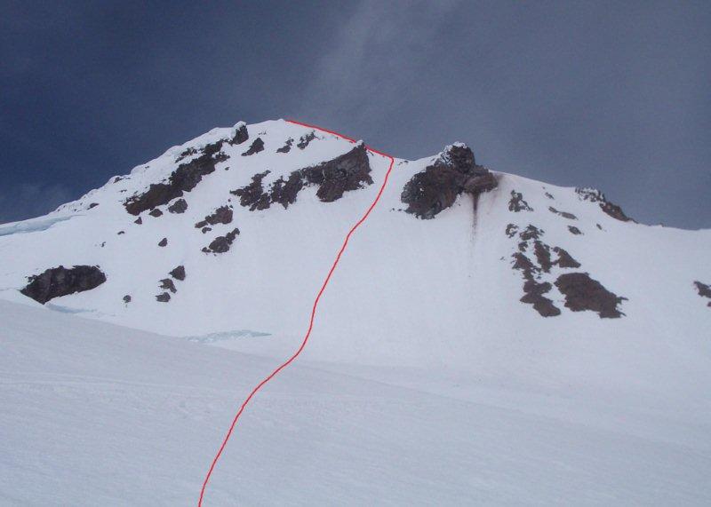
We crossed the Cool Glacier and followed the standard climbing route up the southwest face of Glacier. The snow was hard in places and a strange mixture of soft powder and broken off rime ice in other places. I think the high winds the previous day had stripped the soft snow off the exposed ridges on the west side of the mountain and sprinkled rime ice into the more sheltered swales. We were concerned that the skiing might be less than ideal. Once on top we enjoyed the views and peered over the Cool Glacier headwall on the southeast and the Chocolate Glacier headwall on the northeast. Both aspects looked intimidating. The east ridge looked reasonable and we could see the entrance to the east ridge couloir below. After some discussion we decided that was the way to go.
The crunchy snow on top turned to 6 inches of powder-like smoothness as we took our first turns down the east ridge. Although the east ridge itself is rounded and moderate, its not very wide and the steep drops on both sides provides a nice airy feel. When we arrived at the couloir we discovered it was not to steep (40-45 degrees at the top) and perfectly corned up. The skiing was sublime on smooth perfection. We soared down the Cool Glacier and back to the entrance to the Gerdine where we stopped for lunch and gazed back at the bounty we had harvested on the most isolated of Cascade volcanoes. We had worked hard to reach this point and we were rewarded with the perfect line on the perfect day.
We harvested more excellent corn on the return to camp. We packed up our gear and continued our trip across the White Chuck basin, along the south side of White Mt. to White Pass, and along the ridge to Reflection Pond. Although the pond was still buried in snow, we found a dry spot in the trees on the ridge with running water to set up camp.
The next day we followed the general route of the Pacific Crest trail over to Indian Pass. This was the least fun section of the trip. It was steep traversing with hard sun-cupped snow, tight trees in places, a few patches of dry ground, and a couple incised gullies. It took us 2 hours to cover about 1 mile and I do not recommend it. We speculated that a better route would have involved skinning up the north facing slopes of the ridge coming down from Indian Head Peak to an elevation of about 6,400 ft and skiing down into Indian Creek on the other side. No one wants to climb 800 ft when the traverse looks so straightforward on the map, but it would have been more pleasant in retrospect.
The Skoog party was able to ski 3 miles down Indian Creek. We only got about 0.5 miles (to 4,500 feet) before we had to remove the skis and start walking. Finding the trail through the slide alder required some intricate GPS work and the next 5 miles or so was plagued with patchy snow, running water in the trail, avalanche debris, two shin-deep fords, and generally poor travelling conditions. The final walk out seemed to take forever but the refreshing rinse in the river and cold beers at the trailhead wiped away all the discomfort of the final day, leaving us with memories of an outstanding trip.
We didnt see a single person the entire trip, which seemed astonishing for a 4th of July weekend. We saw old ski tracks on the Walrus Glacier and above Moth Lake and boot tracks on Glacier Peak, so it looks like at least two parties had been on parts of the route during the last couple weeks of June. It truly was a Delectable Tour, blessed with excellent weather, excellent skiing, superb scenery, and a great partner. Andrew and I are already thinking about other high traverses that might provide a similar quality experience.
My photos: https://picasaweb.google.com/116385473347687603893/DakobedTraverse#
Andrew's photos: https://plus.google.com/u/0/photos/114207655356897463350/album/5626131564975601281#photos/114207655356897463350/albums/5626131564975601281
http://www.turns-all-year.com/skiing_snowboarding/trip_reports/index.php?topic=15742.0
Although we didn't reach the summit, I was glad for the excuse to return to the land of high alpine scenery, rugged peaks, and endless ski terrain. Further inspiration to add the Dakobed Traverse to the trip was provided by the Skoog brothers:
http://www.turns-all-year.com/skiing_snowboarding/trip_reports/index.php?topic=13536.msg56989;topicseen#msg56989
http://www.greatoutdoors.com/blogs/gordys/20090615/skiing-the-dakobed-traverse-tools-or-toys
and the Jason Hummel and Kyle Miller trip:
http://www.turns-all-year.com/skiing_snowboarding/trip_reports/index.php?topic=13885.0
http://www.cascadecrusades.org/SkiMountaineering/glacierpeak/dakobedtraverse2009/dakobed2009.htm
(Not to mention a washout on the North Fork Sauk that added 5 road miles to the approach from that direction.)
Andrew McDavid (Andyrew) was enthusiastic for another shot at Glacier and liked the idea of the Dakobed. The late snowpack gave us hope for more skiing than hiking and the forecast looked quite nice for the 5 days with the exception of a minor disturbance during the middle day.
We left the White River Trailhead around noon on Friday after a leisurely departure. We transitioned onto skis at about 4,500 feet and set up camp at Boulder Pass. Our least favorite camp during the trip, there was no running water, not much of a view, and only a small patch of dry ground for cooking and keeping gear off the snow. Camping on the edge off the Walrus glacier would at least offer better views.
The next morning dawned clear and calm and after a leisurely breakfast we crossed over the ridge and started up the Walrus Glacier. We kept to the left hand side of the glacier to avoid most of the crevasses and seracs and found a pleasant line to the col at 8,100 on the shoulder of Clark. The skin up the south side off Clark to the summit was steep in places and made more interesting by the rapidly softening snow. The views from the summit were outstanding and the summit register indicated that one other party had reached the summit in 2011. The ski back to the col provided our first well-earned turns.
We stayed high beneath the north side of Clark to the Richardson Glacier. We debated whether to go above or below the buttress at 7,800 ft on the northwest ridge of Clark and in the end decided to go high. This route required a short ski carry, negotiating a tricky moat, and a turn or two on 50 degree snow before resuming our downward glide across the Richardson. Looking back at what we crossed indicated that the route below the buttress would have been simpler although it was steep and would have dropped us several hundred feet lower than our high route.
As we continued on across the Richardson we had to decide between two cols on the east ridge of Luahna, one at about 7,400 and the other at 7,900. Since climbing Luahna was one of my objectives for the trip, we went for the high col. This was also the route used by the Skoog party and it actually works out quite well although it looks steep from the other side of the Richardson. Unfortunately, climbing and/or skiing the east ridge of Luahna did not look very appealing given the steepness, the soft snow, and a glide crack halfway up the slope. So Andrew watched as I carefully traversed over to the southeast ridge, dropped my skis and scrambled the class 2 rock to the summit. Once on top, the east ridge actually looked like a reasonable climb and ski, although a fall would have been quite unpleasant. My entry in the summit log was the first for 2011.
I returned to the col and a well-rested Andrew and we descended the steep slopes onto the Pilz Glacier. Following the route of the Skoog party, we headed for wind-scoop col at about 8,000 feet above the Butterfly Glacier. Note that skiing down the Pilz Glacier is not recommended by Jason and Kyle.
We did depart from the route taking by the Skoog party who stayed high on the Butterfly glacier to Neyah point and camped high on the ridge. Although they considered crossing the south side of Ten Peak they eventually decided to ski north down Moth Glacier towards Moth Lake. Due to the potential for bad weather and high winds we elected to ski 2,000 feet down the center of the Butterfly Glacier and camp at a lovely col just south-southeast of Moth Lake. It had been a long day and we appreciated the running water and generous patch of rocks, including one large one that provided some shelter from the steady breeze. Based on the descriptions provided by the Skoog brothers, their high route provided outstanding views and good skiing while our low route provided good skiing and a more protected camp. Your choice.
The next day dawned cloudy and windy. We skied down to Moth Lake and passed through the obvious gap at 6,400 feet. Based on some helpful beta provided by Lowell in an email, we traversed across to the top of a steep gully and skied down the gully to about 6,100 feet where we could start the traverse across the north side of Ten Peak. This area was melted out when Jason and Kyle passed through and their trip reports suggest a more challenging passage through this area. Our traverse continued at an elevation of 6,000 to 6,200 feet beneath Ten Peak and was a bit fussy, with several sections of steep traversing across dirty, runneled snow and a couple carries across bands of talus. Eventually we dropped onto the Honeycomb Glacier and began a very pleasant gradual climb back to the high country. The Honeycomb Glacier is big and open with virtually no open crevasses. We were delighted to see bear tracks and numerous elk tracks crossing the glacier from the lower Suiattle basin up and over the col to Lightning Basin. Apparently, the wildlife enjoy high traverses through the area also.
Similar to the Skoog party, we headed for Tiger tower at about 8,000 feet and crossed over to the Suiattle. A lower crossing is also feasible but the views from the upper Honeycomb are not to be missed. We took advantage of gravity and used up about 1,000 feet of vertical to carry us across most of the Suiattle Glacier. It was a short 300 foot climb up to our camp at Glacier Gap between the Suiattle Glacier and White Chuck basin. At this camp we were blessed with running water, dry ground to sleep on, and partial shelter from the wind. We fulfilled our desires from our previous trip through this area and spent the late afternoon skiing the wide open expanses of the upper Suiattle Glacier.
During the night the wind died down and the clouds blew away and we awoke to ideal conditions for an attempt on Glacier Peak. Gravity carried us a long way across the Gerdine Glacier on hard frozen snow with only 300 ft of elevation loss. We put on skins and started the climb up the right hand side of the Gerdine to the col that crosses over onto the Cool Glacier. As we looked up at the Cool Glacier headwall we agreed that that should be left for better skiers (or boarders in the case of Kyle Miller). We did eye the wide couloir further down the east ridge of Glacier that we believe was skied by Monika and RyanL in 2008 (not true as Ryan points out below):
http://www.turns-all-year.com/skiing_snowboarding/trip_reports/index.php?topic=10621.msg43234#msg43234
It hadnt sluffed and looked smooth and wide with no cliffs to fly off or open bergschrunds to fall into.
We crossed the Cool Glacier and followed the standard climbing route up the southwest face of Glacier. The snow was hard in places and a strange mixture of soft powder and broken off rime ice in other places. I think the high winds the previous day had stripped the soft snow off the exposed ridges on the west side of the mountain and sprinkled rime ice into the more sheltered swales. We were concerned that the skiing might be less than ideal. Once on top we enjoyed the views and peered over the Cool Glacier headwall on the southeast and the Chocolate Glacier headwall on the northeast. Both aspects looked intimidating. The east ridge looked reasonable and we could see the entrance to the east ridge couloir below. After some discussion we decided that was the way to go.
The crunchy snow on top turned to 6 inches of powder-like smoothness as we took our first turns down the east ridge. Although the east ridge itself is rounded and moderate, its not very wide and the steep drops on both sides provides a nice airy feel. When we arrived at the couloir we discovered it was not to steep (40-45 degrees at the top) and perfectly corned up. The skiing was sublime on smooth perfection. We soared down the Cool Glacier and back to the entrance to the Gerdine where we stopped for lunch and gazed back at the bounty we had harvested on the most isolated of Cascade volcanoes. We had worked hard to reach this point and we were rewarded with the perfect line on the perfect day.
We harvested more excellent corn on the return to camp. We packed up our gear and continued our trip across the White Chuck basin, along the south side of White Mt. to White Pass, and along the ridge to Reflection Pond. Although the pond was still buried in snow, we found a dry spot in the trees on the ridge with running water to set up camp.
The next day we followed the general route of the Pacific Crest trail over to Indian Pass. This was the least fun section of the trip. It was steep traversing with hard sun-cupped snow, tight trees in places, a few patches of dry ground, and a couple incised gullies. It took us 2 hours to cover about 1 mile and I do not recommend it. We speculated that a better route would have involved skinning up the north facing slopes of the ridge coming down from Indian Head Peak to an elevation of about 6,400 ft and skiing down into Indian Creek on the other side. No one wants to climb 800 ft when the traverse looks so straightforward on the map, but it would have been more pleasant in retrospect.
The Skoog party was able to ski 3 miles down Indian Creek. We only got about 0.5 miles (to 4,500 feet) before we had to remove the skis and start walking. Finding the trail through the slide alder required some intricate GPS work and the next 5 miles or so was plagued with patchy snow, running water in the trail, avalanche debris, two shin-deep fords, and generally poor travelling conditions. The final walk out seemed to take forever but the refreshing rinse in the river and cold beers at the trailhead wiped away all the discomfort of the final day, leaving us with memories of an outstanding trip.
We didnt see a single person the entire trip, which seemed astonishing for a 4th of July weekend. We saw old ski tracks on the Walrus Glacier and above Moth Lake and boot tracks on Glacier Peak, so it looks like at least two parties had been on parts of the route during the last couple weeks of June. It truly was a Delectable Tour, blessed with excellent weather, excellent skiing, superb scenery, and a great partner. Andrew and I are already thinking about other high traverses that might provide a similar quality experience.
My photos: https://picasaweb.google.com/116385473347687603893/DakobedTraverse#
Andrew's photos: https://plus.google.com/u/0/photos/114207655356897463350/album/5626131564975601281#photos/114207655356897463350/albums/5626131564975601281
Wow. My wife and I did Clark Saturday - Monday and saw your tracks on Sunday. We speculated who was this crazy. Now we know. Excellect work!
Great trip you guys! What a great place to spend a nice weather window.
I may be misunderstanding, but I'm pretty sure Monika and I skied what you're describing as the Cool Glacier Headwall. Here's our line:
I may be misunderstanding, but I'm pretty sure Monika and I skied what you're describing as the Cool Glacier Headwall. Here's our line:
author=ryanl link=topic=21418.msg91686#msg91686 date=1310191365]
I may be misunderstanding, but I'm pretty sure Monika and I skied what you're describing as the Cool Glacier Headwall. Here's our line:
Opps, you're correct. So that's the line we should call Monika's Couloir. It's much more impressive that the line we skied (see below) and more fitting for her. The difference in snow coverage is quite dramatic. Here's a photo of the line we skied.
Nice work Scott and Andrew. Glad you finally got Glacier Scott - and glad the route worked out.
Looks like you were right on about the coverage. I need to stop the rest of my life for a couple day so I can enjoy a slice of that....
Looks like you were right on about the coverage. I need to stop the rest of my life for a couple day so I can enjoy a slice of that....
Thanks for the detailed report...was just thinking about this area.
excellent andrew and scott - been wanting to do this one, some day ;-)
Great job Scott and Andrew... great adventure and ski tour full of solitude.
Great trip guys!
Such a beautiful place...
Interesting to hear about the White Pass to Indian Pass section. It sounds like you hit it during the worst transitional period. When we did it in early June 2009, it was almost entirely skiable and not unpleasant. When Jason and Kyle did it a month later, I think they walked that section, which was probably okay as well. It's only during the melt-out that this section is bad.
=========
Aside: I'm sorry that the thumbnail images I included in my 2009 report are dead. I'd replace them with full-size images, but TAY apparently locks the thread after a certain time. Is there a good reason for this?
Yeah, it was bad for us on that crossing over to Tenpeak. The stream was raging and I ended up using a very suspect snowbridge to ski across...as I was not comfortable at all to walk across.
It's amazing how much snow is still around. I just skied to about 4200 feet...to just above the crossing of Bachelor Creek on July 7th while doing the Ptarmigan Traverse! I didn't get that far in early/mid June last year.
It's amazing how much snow is still around. I just skied to about 4200 feet...to just above the crossing of Bachelor Creek on July 7th while doing the Ptarmigan Traverse! I didn't get that far in early/mid June last year.
author=Lowell_Skoog link=topic=21418.msg91740#msg91740 date=1310326992]
Aside: I'm sorry that the thumbnail images I included in my 2009 report are dead. I'd replace them with full-size images, but TAY apparently locks the thread after a certain time. Is there a good reason for this?
TAY's done that since long before my time -- it's an anti-spam measure, mostly, to prevent spam posters from filling the dozens of separate forums with posts, should they get in. It's been less of an issue since I changed over to a registration-approval model for sign-ups.
There's currently a 4-month window for open TRs -- current month plus 3 months back.
Re: thumbnails -- yeah... it needs to be fixed. Lowell, I went ahead and changed your thumbs in that TR to linked images.
Great TR Scott -- that's the trip we were hoping to do over the fourth, but we didn't have the extra time to make it happen. Excellent stuff.
nice one Scottt and Andrew! I was looking for the Ptarmigan report, but this is better yet. Were you tempted to ski Tenpeak at all? Been looking at that one...
author=cumulus link=topic=21418.msg91783#msg91783 date=1310396125]
Were you tempted to ski Tenpeak at all?
We looked up the north couloir as we traversed by but decided we'd rather spend our time skiing the Suiattle once we'd settled into camp.
author=cumulus link=topic=21418.msg91783#msg91783 date=1310396125]
Were you tempted to ski Tenpeak at all? Been looking at that one...
I was a little tempted, but the bottom ~1000 feet were really runneled and nasty looking. It looked smoother higher up.
Here's a few more photos:
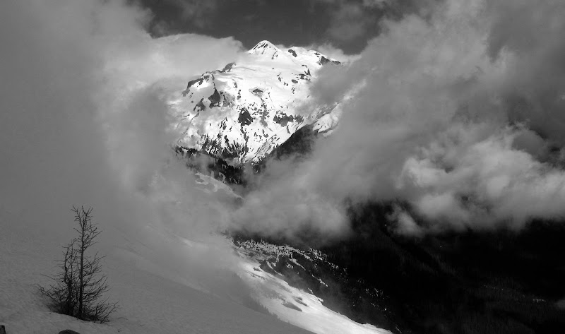
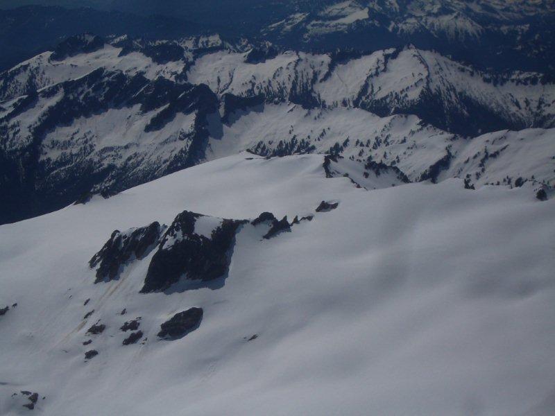
Clouds added drama to view of glacier from the Tenpeak traverse
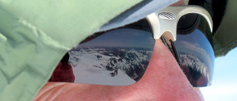
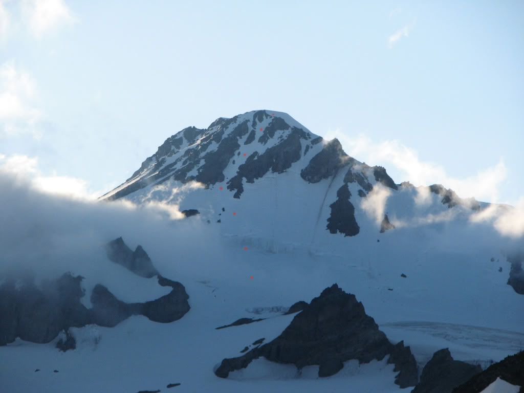
Scott looks out over the Dakobed range from the summit of Glacier
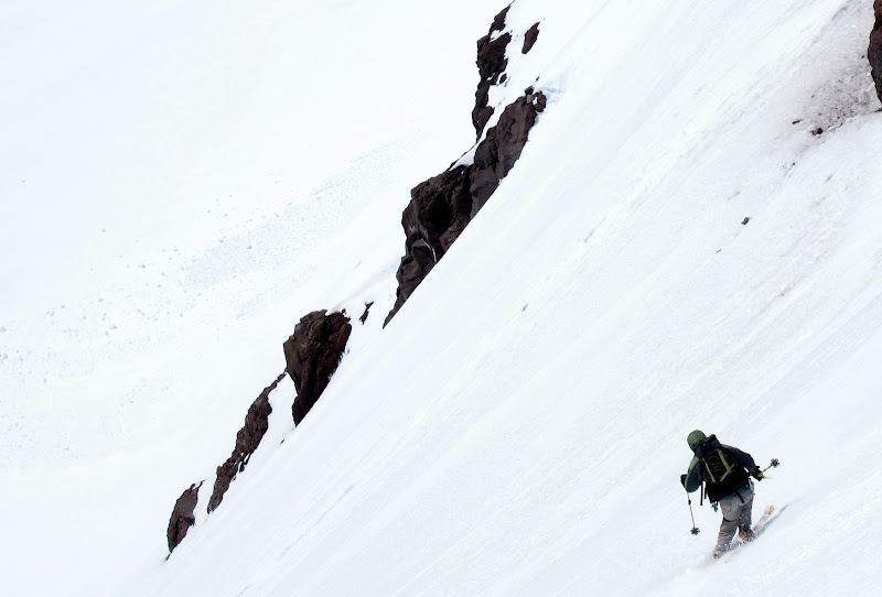
Scott cranking turns down the headwall
Reply to this TR
Please login first: