June 17, 2011, Silver Peak
6/17/11
WA Snoqualmie Pass
3755
7
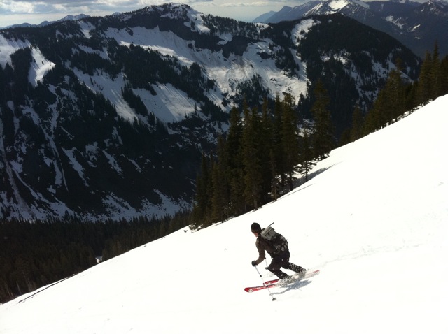
Silver summer ski season is in session! Road is drivable past the switchbacks and more. We found 3" corn slush on west facing slopes 5-7pm. Stickiness was only moderate.
Good on ya Silas ! For a minute I thought you were lost in Oregon?
It really was a great day up there!
Sking with Silias is always entertaining


Please share your approach route and decent. Planning on skiing it on the solstice
Thanks
Thanks
author=powcarvin link=topic=21192.msg90843#msg90843 date=1308611447]
Please share your approach route and decent. Planning on skiing it on the solstice
Thanks
Start and end from Windy Pass....USGS Lost Lake quad or Green Trails Snoq. Pass.
Happy Solstice,
Morgan
"Windy Pass" isn't a USGS designation -- but it is the moniker used by the Summit Nordic Center (and it is an accurate description)
http://www.summitatsnoqualmie.com/files/pdf/nordic_2011_map.pdf
This tricky part this time of year is finding the start of the road -- here is a hint -- follow your nose -- you'll pass by something very stinky right after you leave the pavement and hit the gravel.
http://www.summitatsnoqualmie.com/files/pdf/nordic_2011_map.pdf
This tricky part this time of year is finding the start of the road -- here is a hint -- follow your nose -- you'll pass by something very stinky right after you leave the pavement and hit the gravel.
author=Randy link=topic=21192.msg90859#msg90859 date=1308633642]
"Windy Pass" isn't a USGS designation -- but it is the moniker used by the Summit Nordic Center (and it is an accurate description)
It also is a Green Trails Map designation (Map # 207 and Map #207S), which combined with the USGS Quad mentioned above (my personal choice) provides excellent navigation and location tools for the area.
Morgan
Reply to this TR
Please login first: