June 4-5, 2011, Rainier, Emmons Terminus to Summit
6/4/11
WA Cascades West Slopes South (Mt Rainier)
45566
27
June 4-5, 2011, Mount Rainier, Entire Emmons Glacier from Terminus to Summit
Summary: Our party enjoyed a near-complete ski ascent and ski descent of Mount Rainier via the entire Emmons Glacier, from White River Campground at 4300 ft to the Emmons Moraine to the glacier's terminus to Camp Schurman, and then the next day up the standard route to the crater rim at just over 14300 ft. We decided to forgo the last bit to Columbia Crest due to marginal weather with incoming dense clouds and a gusty 40+ mph SE wind on the rim, a very appropriate decision. Skied from the crater rim all the way down the entire Emmons Glacier and right to the edge of the parking lot, with skins needed for the last 1.5 miles of up-down skiing from Emmons Moraine to White River Campground. A ski ascent and descent of just over 10000 vertical feet, taking an excellent variation which is more remote and scenic than the standard Emmons route (via Inter Glacier), but which only works when there is deep snowpack below 5000 ft.
(click for double-size version)
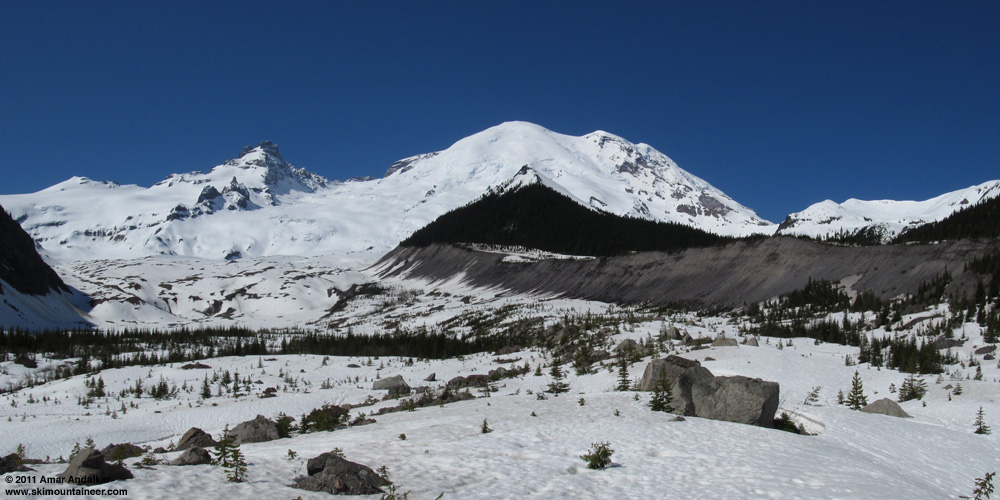
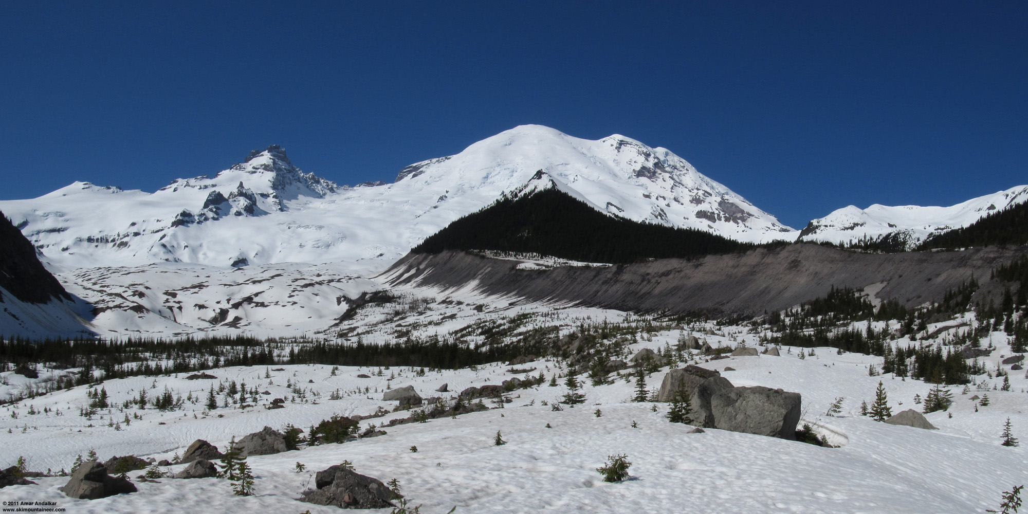
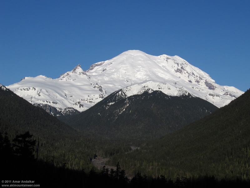
Two-shot panorama of the entire Emmons Glacier from near 4800 ft, atop the large debris avalanche deposit below its terminus. This deposit and all of the boulders on the surface are from the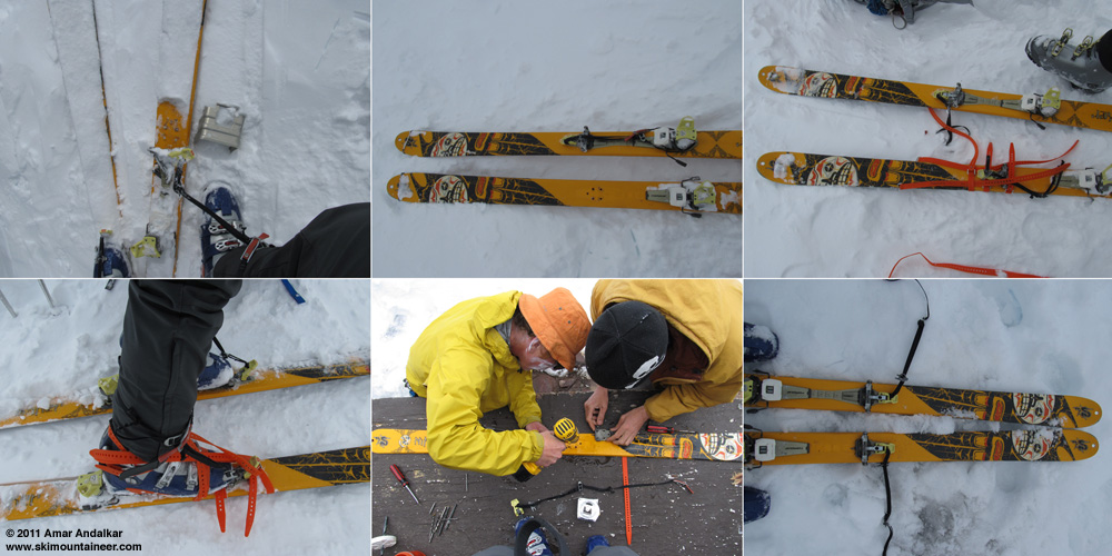
(click for double-size version)
Just after the toepiece ripped out at 13200 ft. * Preparing to remount it at 14100 ft. * Remounted with Voile straps.
Boot fully strapped to the ski, ready to ski down from 14100 ft. * Ryan and David Gottlieb remounting the toepiece at Camp Schurman. * Ready to ski the rest of the way.
Anyway, it was a spectacular trip with great company, good snow conditions, and mostly fine weather, except for the unexpected high clouds and high winds which moved in on summit day. Very satisfying to finally ski this exceptional glacier in its entirety after many years of looking and longing to do so, especially after having done a half-dozen descents of its oft-skied upper half since 1999. The entire Emmons is a trip which is rarely done due to access issues with the road being closed while there is sufficient snow down low to make the route viable, and even with this year's huge late spring snowpack, it was important to try it as soon as possible after the White River Road belatedly opened on June 2.
(click for double-size version)
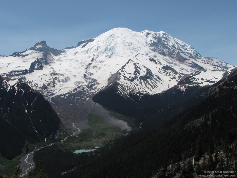
View of the entire Emmons Glacier from Emmons Vista near Sunrise, on June 26, 2009. Much less snow cover in 2009 than this year.
Summary: Our party enjoyed a near-complete ski ascent and ski descent of Mount Rainier via the entire Emmons Glacier, from White River Campground at 4300 ft to the Emmons Moraine to the glacier's terminus to Camp Schurman, and then the next day up the standard route to the crater rim at just over 14300 ft. We decided to forgo the last bit to Columbia Crest due to marginal weather with incoming dense clouds and a gusty 40+ mph SE wind on the rim, a very appropriate decision. Skied from the crater rim all the way down the entire Emmons Glacier and right to the edge of the parking lot, with skins needed for the last 1.5 miles of up-down skiing from Emmons Moraine to White River Campground. A ski ascent and descent of just over 10000 vertical feet, taking an excellent variation which is more remote and scenic than the standard Emmons route (via Inter Glacier), but which only works when there is deep snowpack below 5000 ft.
(click for double-size version)
Two-shot panorama of the entire Emmons Glacier from near 4800 ft, atop the large debris avalanche deposit below its terminus. This deposit and all of the boulders on the surface are from the
(click for double-size version)
Just after the toepiece ripped out at 13200 ft. * Preparing to remount it at 14100 ft. * Remounted with Voile straps.
Boot fully strapped to the ski, ready to ski down from 14100 ft. * Ryan and David Gottlieb remounting the toepiece at Camp Schurman. * Ready to ski the rest of the way.
Anyway, it was a spectacular trip with great company, good snow conditions, and mostly fine weather, except for the unexpected high clouds and high winds which moved in on summit day. Very satisfying to finally ski this exceptional glacier in its entirety after many years of looking and longing to do so, especially after having done a half-dozen descents of its oft-skied upper half since 1999. The entire Emmons is a trip which is rarely done due to access issues with the road being closed while there is sufficient snow down low to make the route viable, and even with this year's huge late spring snowpack, it was important to try it as soon as possible after the White River Road belatedly opened on June 2.

(click for double-size version)
View of the entire Emmons Glacier from Emmons Vista near Sunrise, on June 26, 2009. Much less snow cover in 2009 than this year.
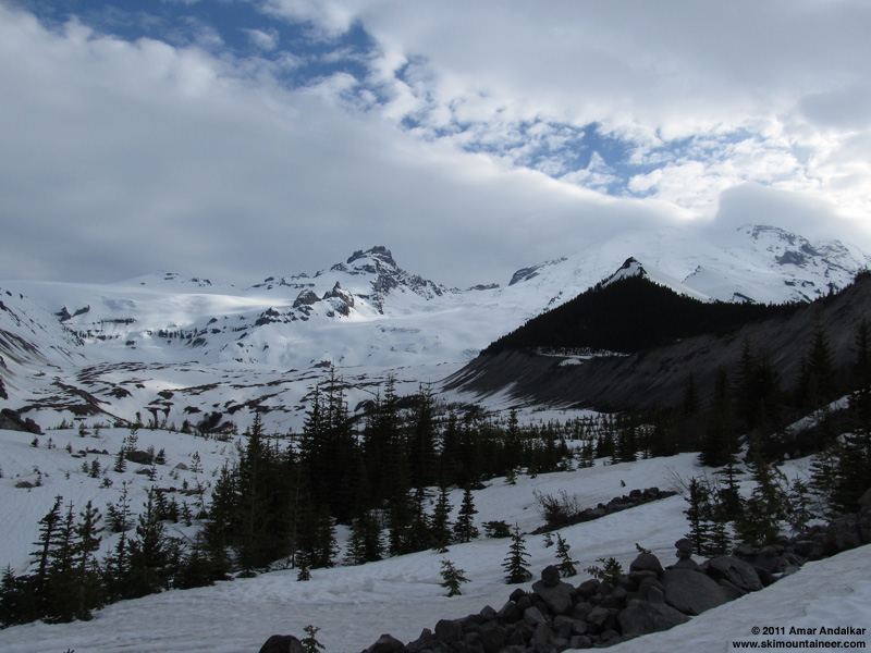
Details: The Emmons Glacier is the largest glacier by area in the contiguous United States, covering over 4 square miles along the northeast face and flanks of Mount Rainier. It extends over 9000 vertical feet from the rim of the East Crater near 14200 ft down to its terminus near 5000 ft, which is among the largest vertical drops of any glacier in the lower 48 (perhaps trailing only its companion the Winthrop Glacier in that category). The upper portion of the combined Emmons-Winthrop Glaciers is the most commonly skied summit route on Mount Rainier, approached via the adjacent valley of Glacier Basin and Inter Glacier, but I've long wanted to ski the entire Emmons Glacier from summit to terminus and all the way to the trailhead at White River Campground (4300 ft). It's a pure and direct line offering over 10000 vertical feet of skiing down one of the most prominent and often photographed faces of the Mountain.
Morning view of Rainier from SR 410, well worth driving the extra half-mile south of the White River turnoff.
However, adequate snow cover to ski the lower portions of the route (below about 5000 ft) typically exists only during late winter and early spring, but the road to White River does not normally open until just before Memorial Day weekend. Thus skiing the entire glacier usually requires a snowmobile or a multi-day approach, so the route is very rarely skied. But this year, with an exceptional late-spring snowpack at elevations above 4000 ft in the Cascades, would be the best chance in many years to try the route. The crux of the route would be finding a way to cross the Inter Fork of White River safely, since the Glacier Basin Trail stays along the north side while the Emmons lies to the south.
(click for double-size version)
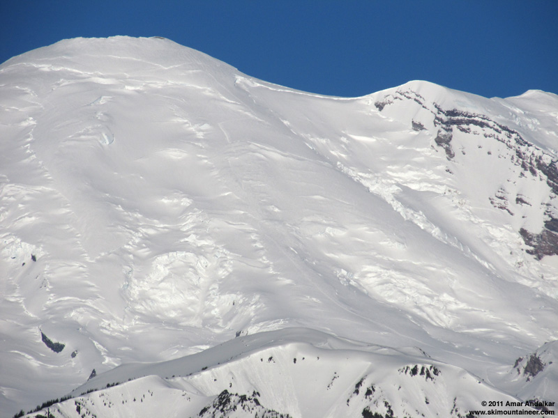
Telephoto view (336 mm lens) from SR 410 showing the Emmons route from Camp Schurman (lower right) to the summit. Note the open bergschrund which completely blocks the standard traverse going right to the 13600 ft saddle, parties will have to ascend directly to the crater rim this year.
A blog post showed that climbing rangers had skied the route on May 2, using the plowed White River road which remained closed to the public. The road was scheduled to open on May 20, then rescheduled for May 27, but the park failed to meet either of those dates, and it finally opened on June 2. Luckily, due to the abnormally cold and wet Northwest spring which brought repeated snowfalls and delayed melting, the snowpack above 4000 ft had barely decreased over the entire month of May. Paradise at 5400 ft on Rainier's south side boasted its 2nd greatest June 1 snowdepth in 91 years of data (213", about 190% of normal), while Crystal Mountain located 15 miles NE of the summit and 8 miles NE of White River Campground still had 88" at its 4480 ft base station on June 1 (over 200% of normal), losing only 19" since May 1 which was mostly due to consolidation.
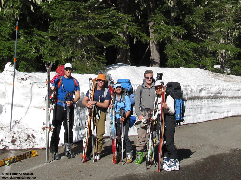
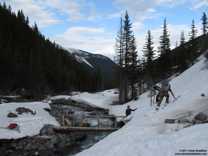
Even more fortunately, the forecast looked stellar for the first weekend after the road opened: mostly sunny, freezing level 11000-12000 ft. So by Friday evening, I had easily managed to convince a crew of 5 others to join me: Greg, Ryan, Khanh, Tobae, and Tim, all strong ski mountaineers with prior Rainier summits. We planned to leave town early Saturday and arrive at White River Ranger Station by 7am when it opened, in order to register and secure some of the limited number of spots at Camp Schurman in case it was a busy weekend. Climbing ranger David Gottlieb was manning the desk when we arrived, and he was a fount of useful information on the route and especially the approach, having skied it both on May 2 and again a few weeks later. He said that crossing near the end of the newly-built Glacier Basin Trail segment at the junction with the Emmons Moraine Trail would be best (about 1 mile from the trailhead), using either a large log or possibly the log trail bridge on the Emmons Moraine Trail, which had a steep snowbank along its far side. Note that this bridge was finally installed in September 2010 to reopen that trail, almost 4 years after washing out in the November 2006 floods.
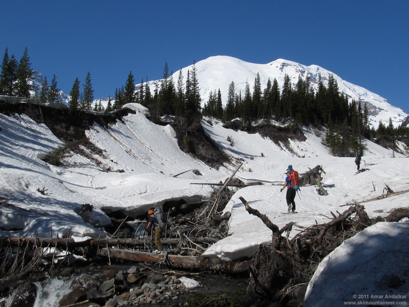
We skinned out from the trailhead at 8:30am, carrying glacier gear and two ropes, but no avy gear. Snowdepth at the parking lot was about 4-5 ft, but as we reached the newly-built Glacier Basin Trail segment after a half-mile, there were several short and long bare sections of trail especially on bridges. Although we continued skinning across those, the trail became very bare at the sunny pair of switchbacks, so we continued straight through the woods instead and dropped down to the river bank, eventually finding an acceptable log to cross at about 4800 ft.
Crossing the Inter Fork of White River on a log near 4800 ft.
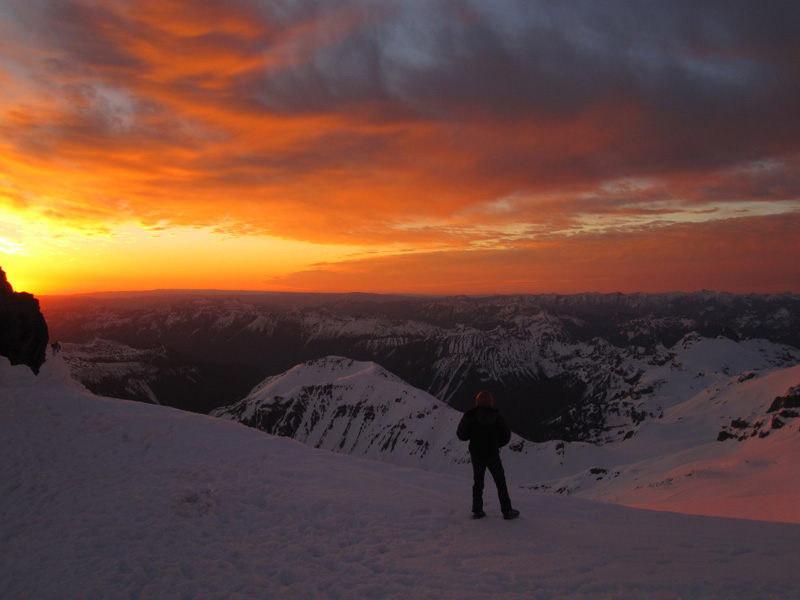
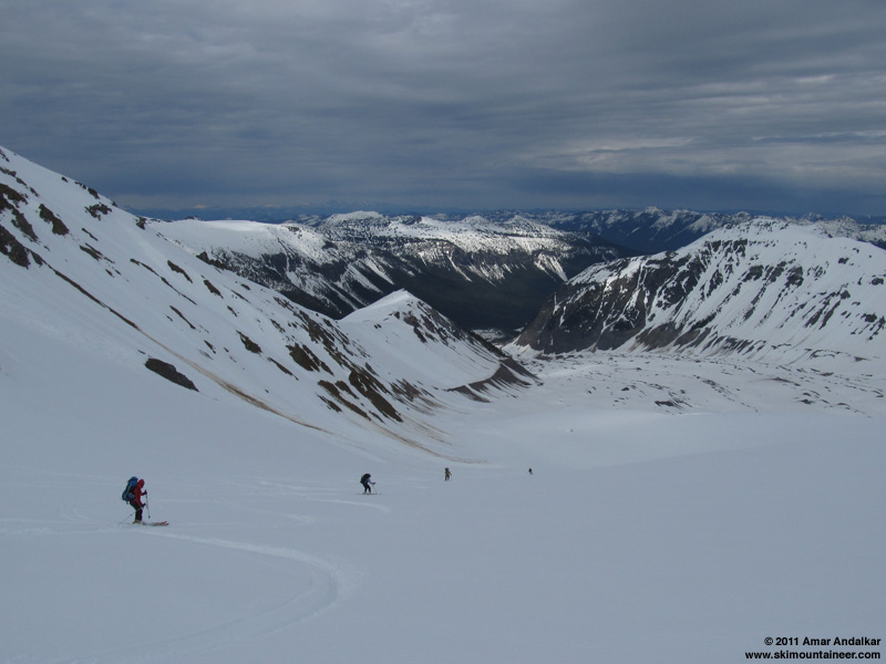
A short traverse across the Emmons Moraine and minor bushwhacking through the immature young forest brought us out into the open atop the 1963 rockfall avalanche deposit, looking directly at the terminus of the Emmons Glacier and up its entire length to the summit (see first photo above). Just a spectacular place, with an outstanding view of Big Tahoma and Little Tahoma rising above the glacier's trough.
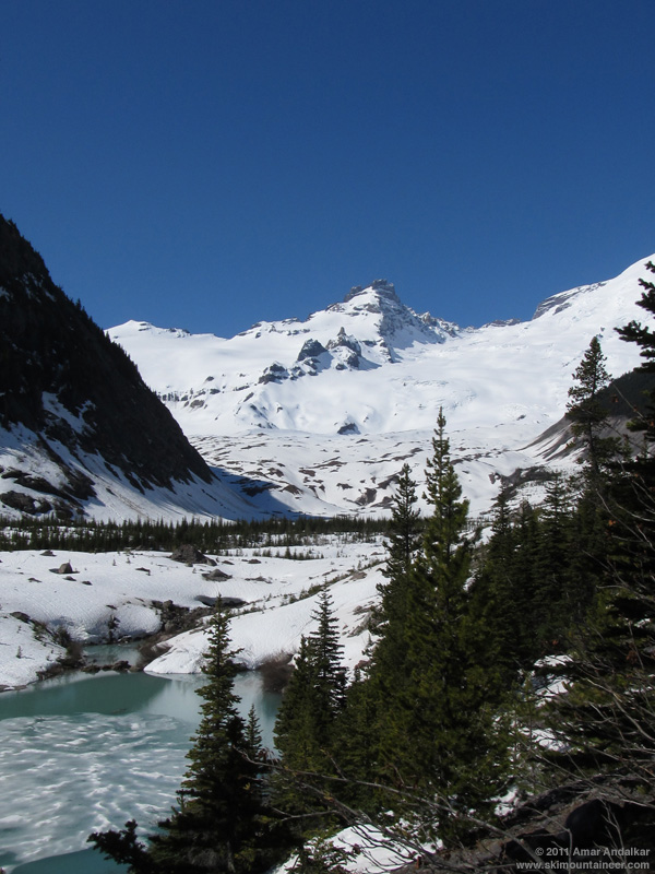
A bright green glacial pond atop the 1963 rockfall avalanche deposit, with Little Tahoma rising above. This pond is currently much larger than the tiny pond shown on the topo map, revealing the likely presence of stagnant glacial ice within the deposit and the moraines buried under it. Melting of this stagnant ice has apparently been enlarging the pond's basin.
From here, the broad open glacier is basically a highway leading directly to Camp Schurman. The glacier's surface was covered with recent new snow above 6000 ft, with only a single faint skin track from sometime several days earlier. Easy travel skinning on a supportive crust, which sat atop 1-2 ft of mushy rounded grains that one could punch a ski pole into.
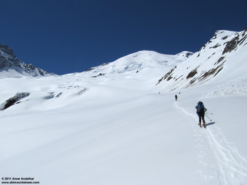
A welcome downslope breeze kept temperatures tolerable in the blazing sunshine on the glacier, and we enjoyed the remoteness of this route variation. We would see no one else from the parking lot until reaching Camp Schurman. Lots of wet slides from the sunny south slopes of Mount Ruth to our right, but the snow on the glacier was stable and not sluffing or sliding. Crevasses were well buried and not an issue, except a few incipient cracks near 9000 ft where our route joined the standard route descending from Inter Glacier onto the Emmons.
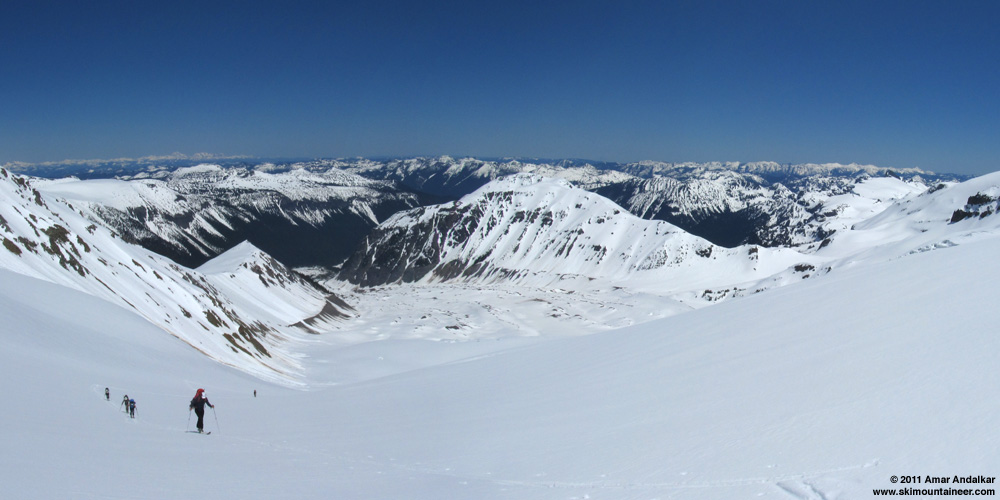
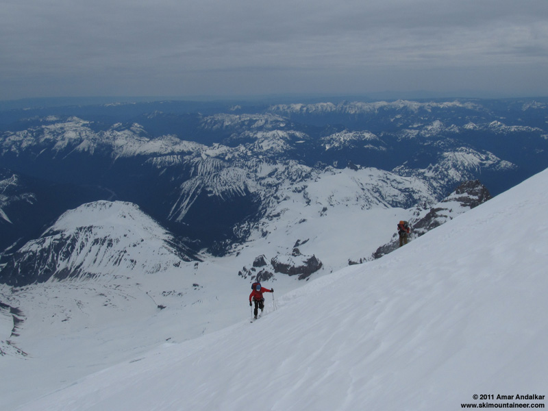
Two-shot panorama looking down the Emmons Glacier from about 8000 ft.
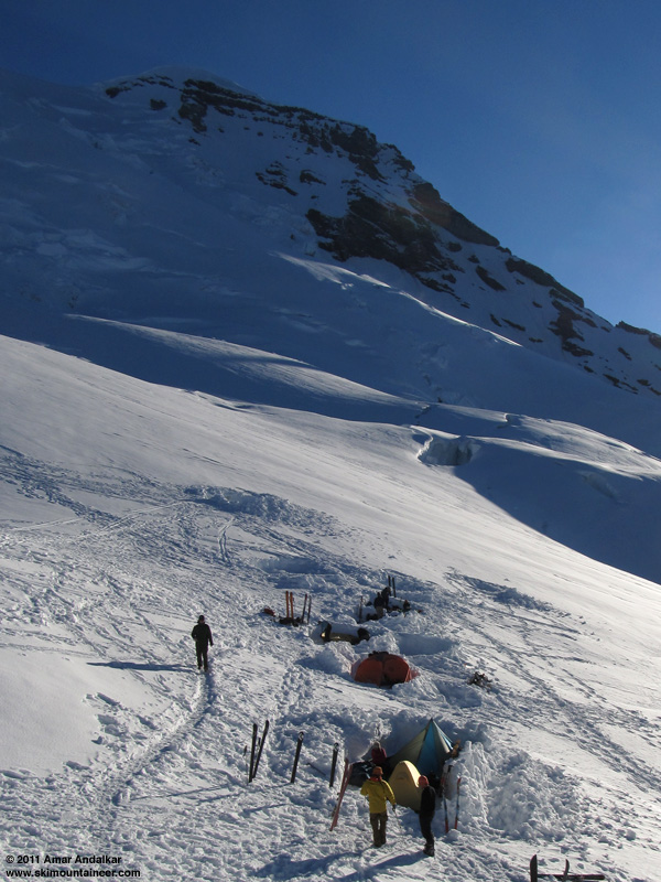
It was almost 4pm by the time we reached Camp Schurman, a fairly tiring haul from the car. A bit chilly there with an easterly breeze. We set up camp in a large vacated site with ample snow-block walls, a MegaLight, a FirstLight, plus two bivy sacks out in the open. After dinner and melting lots of water, we got to bed early, unfortunately missing the sunset which is usually spectacular looking down from the camp at Puget Sound and the Olympics. After much indecision about whether to boot or skin the next day, we had finally planned to leave the next morning in two groups: one team of three heading up at 5am on foot and roped up, the other leaving an hour or two later and hoping that the snow would have softened enough to skin up the entire route. I had only ever successfully skinned the Emmons-Winthrop route once, on an amazing July 2009 trip skiing up and down all three summits. I've cramponed the entire way from Schurman to summit most of the times I've skied this route, as had the others in our group. We had serious doubts whether the route would be skinnable the next day.
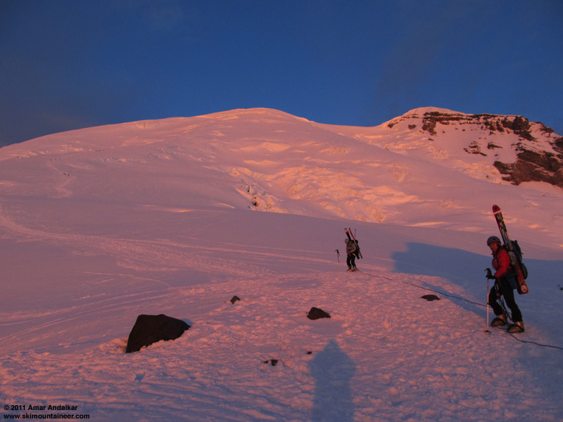
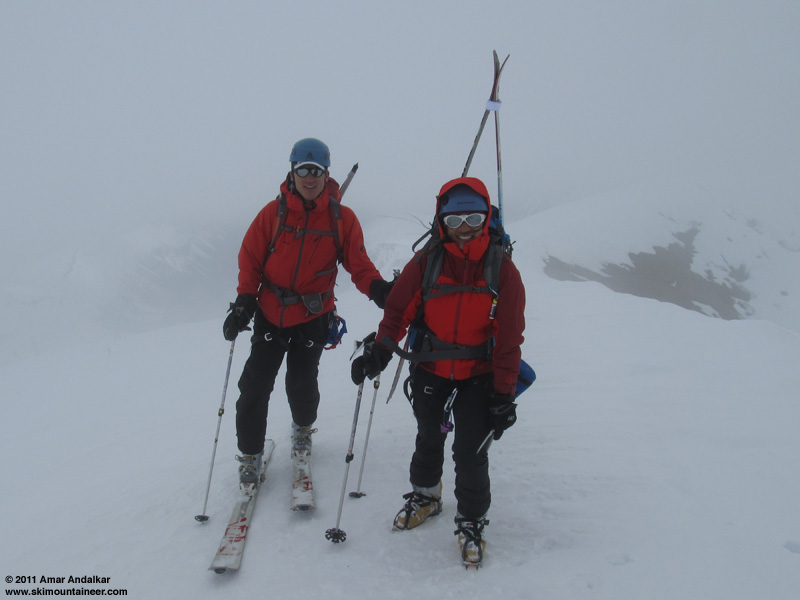
[hr">The spectacular rosy colors of sunrise on the Emmons the next morning made up for missing the sunset. Tobae, Khanh, and Tim headed up at sunrise, while Ryan, Greg, and I had just awoken and started getting ready to go. The mountain above was totally clear, but off to the east an unexpected deck of high clouds was looming, enhancing the sunrise but putting snow conditions for skinning in doubt.
The incoming high clouds at sunrise (photo by Khanh Quach).
Our first team heading out from camp.
The three of us finally set out at 6:45am, on skins with ski crampons and wearing harnesses but not roped, with high clouds now mostly obscuring the sun. Despite the lack of intense morning sun, the snow conditions turned out to be excellent for skinning, with solid grip and no slip on the smooth snow beside the typically messy Emmons bootpack.
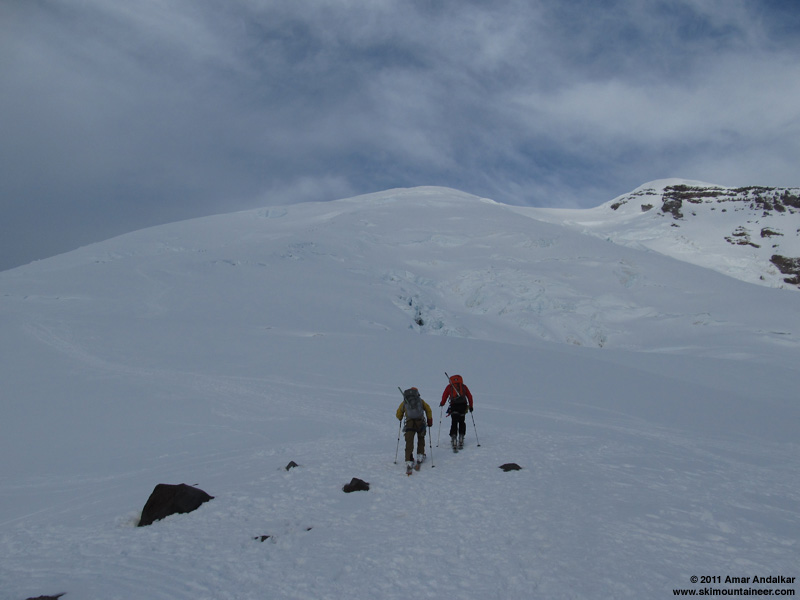
We took turns breaking trail in broad gentle efficient switchbacks, seeing faint traces of an older much steeper skintrack in places. The clouds thickened ominously overhead, while off to the north it was entirely clear over the central and northern Cascades.
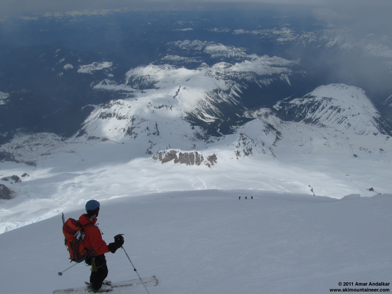
We made rapid progress up to nearly 12000 ft, where we hit the first steeper section between a few partially exposed seracs and crevasses, including a section of exposed blue glacial ice. We considered putting the skis on our backs and roping up, but decided to keep skinning. A pretty good decision, the route was entirely skinnable without any major slips by any of us, although the caution and concentration needed to skin the steeper bits slowed our pace considerably.

Skinning past exposed blue glacial ice near 12000 ft, with a narrow corridor of snow between seracs and crevasses to the right.
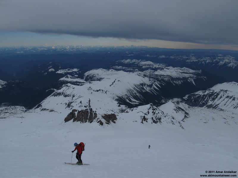
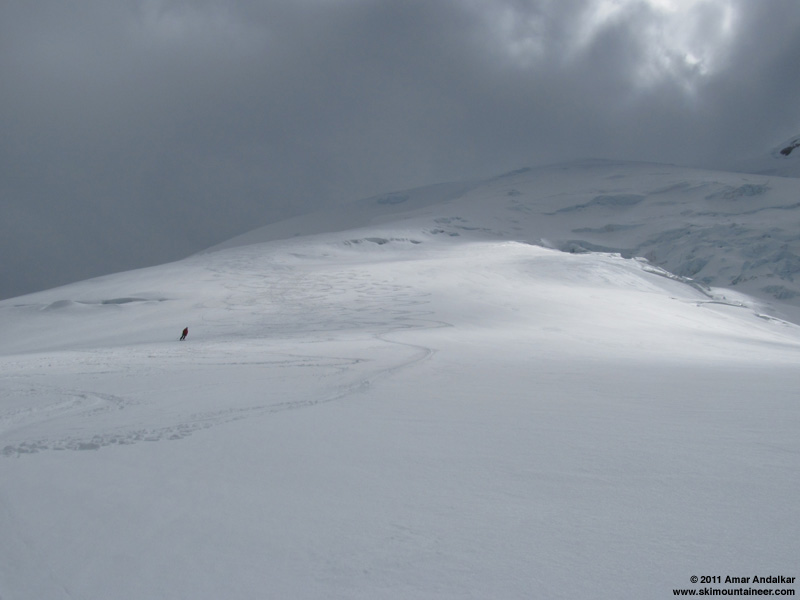
The high clouds were moving from east to west, and clearer skies off to the east gave hope that it might clear out. But the cloud deck was now sprouting streamers of virga, and eventually it snowed briefly on us a couple of times.
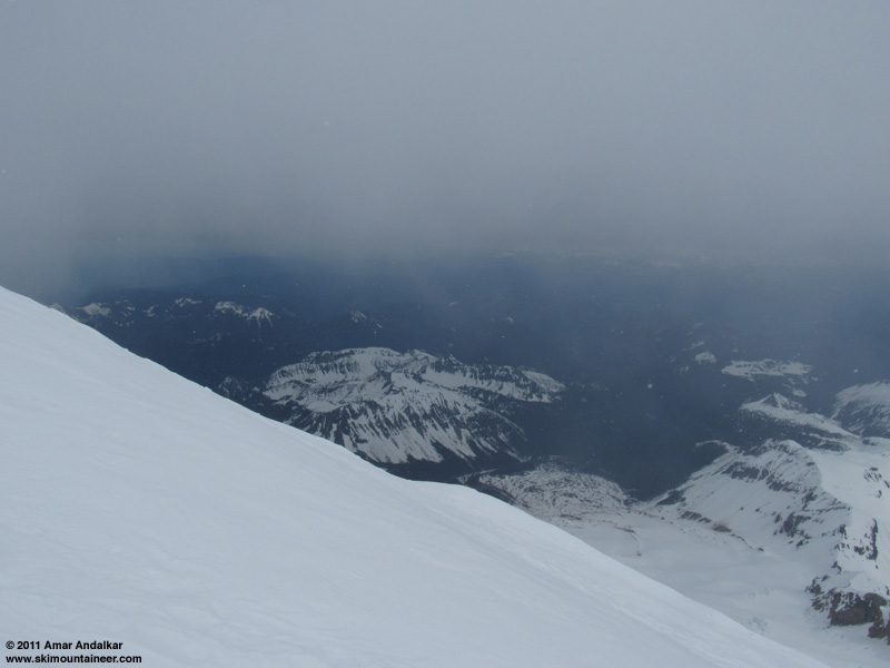
Yes, it's snowing! Around 10:15am, near 12500 ft, with the terminus of Winthrop Glacier visible nearly 8000 ft below us.
The first open crevasse which needed to be crossed by snowbridge was near 12700 ft, and then the route traversed slightly east to the right edge of the bergschrund at 13000 ft, which required a short section of sidestepping downhill about 5 vertical feet to negotiate.
Greg gingerly sidestepping across the snowbridge at 13000 ft, Ryan photographing.
We had almost caught up to the other three by 13200 ft, I was in the lead setting the skin track only a few yards below them, when suddenly it happened: I looked down and knew instantly that the toepiece had ripped entirely out of my right ski. I couldn't avoid spewing a few obscenities seconds later as the full weight of what this meant hit me. I was screwed. I was clearly not going to complete a full ski ascent of the entire Emmons Glacier. I was probably not going to complete a full ski descent of the entire Emmons Glacier either. I was going to have to walk the rest of the way to the summit, and then most likely have to walk down the entire f***ing Mountain, stumbling and sliding and postholing just like those climbers on foot that ski mountaineers feel so superior to, while my partners would be ripping turns down the whole route in style. *&^%$#@!
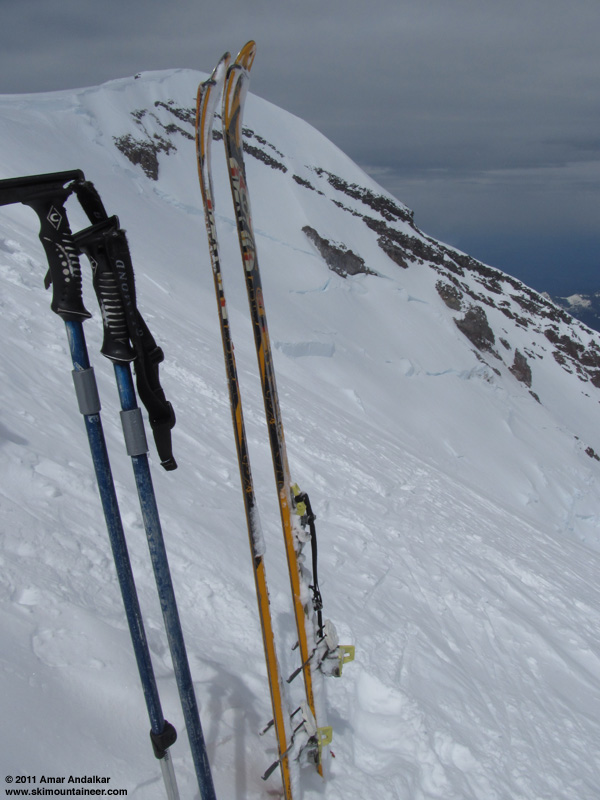
Not good: something is missing from one of my skis at 13200 ft, with the 13720 ft summit of Curtis Ridge beyond.
Our team on foot asked what they could do to help, but I told them "nothing", just keep going and we'll figure it out. I put the skis on my back and followed them up the bootpack, while Greg and Ryan kept on skinning. At least Greg was confident that we could remount the binding somehow, enough for me to ski down. The easterly wind was getting stronger and gustier as we climbed, and the cloud deck was looking more and more threatening, although a lenticular was definitely not yet forming.
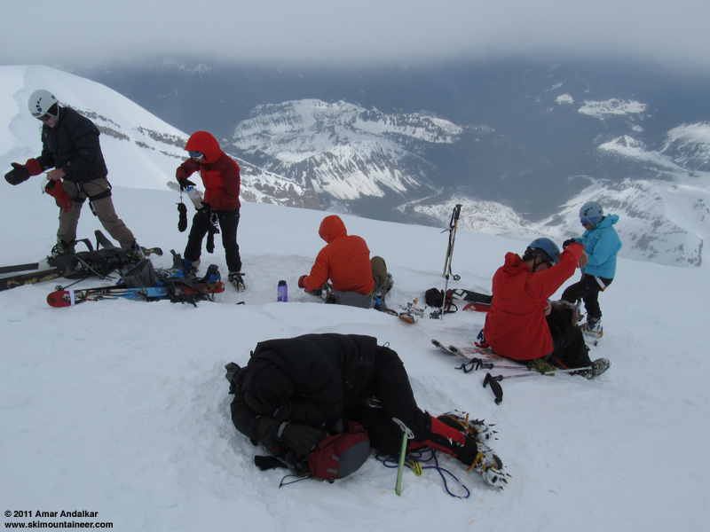
Our group at 14100 ft, with a random climber curled up in front waiting for his partners to catch up.
We regrouped at about 14100 ft, in a spot slightly sheltered from the wind but almost at the edge of the cloud deck, and considered turning around. But several of us wanted to continue, so we decided to keep going. We reached the rim near 14300 ft just before 1:30pm, to find the wind gusting at 40+ mph, making it hard to stand with skis acting as sails on the pack. In a near whiteout we continued a short distance up along the rim before calling it quits. Ryan and Greg had made it all the way from the parking lot up to here on skins, but it was definitely not worth the discomfort or the risk of continuing along the rim to Columbia Crest, probably still 10 minutes away, when the clouds could fully envelop us at any moment.
Greg and Khanh at our high point on the crater rim, with the rest of the group just a few minutes behind.
We quickly retreated back down to 14100 ft, and Greg and Ryan started helping to remount my toepiece, while the others began their ski descent. It took about 30 minutes to clean out the holes, clean the frozen rotten-wood / epoxy mixture off the screws, and remount the binding in the same holes using my Leatherman tool, then strap it on very tightly to the ski with my two 15" Voile straps. Another five 24" Voile straps from Ryan were used to secure my boot to the ski and binding, which took another 10 minutes. A total of four Voile straps passed under my right ski, making it extremely grippy on any firmer snow -- it was almost impossible to turn left except by jump-turning. I eventually figured out that it was faster and safer to just sideslip the majority of the route with my good left ski downhill, making turns only on the patches of softer powdery snow. The snow was generally firm windpacked powder with sections of softer powder, but luckily there was no ice. If it had been icy, I probably would have needed to crampon down on foot instead of staying on skis.
Finally skiing down at 2:30pm.
It took an exhausting and painful hour-and-half for me to reach Camp Schurman around 4pm, with Greg running sweep uphill of me in case of disaster. The snow softened into mushy corn below 11500 ft on the Emmons Corridor, and I could finally make turns for real, nice ones with the left leg and cautious jerky ones with the right. The toepiece held until camp, but just barely: it had partially ripped out again and was being held on only by the Voile straps, along with the straps holding my boot directly to the ski.
Greg carving turns in the soft corn below the Emmons Corridor.
The rest of the group had already arrived and informed David Gottlieb of our situation (he had also skinned up via the Emmons terminus later on Saturday evening). He offered a cordless drill to help us remount the toepiece, which was an amazing stroke of good fortune. I stood atop the workbench outside the ranger hut with my boot used as a measuring guide, while Ryan and Dave remounted the toepiece about 1cm back, taking advantage of half the 26mm travel of the Vertical FT heel. Done in just about 5 minutes. Thanks for all the help, Dave!
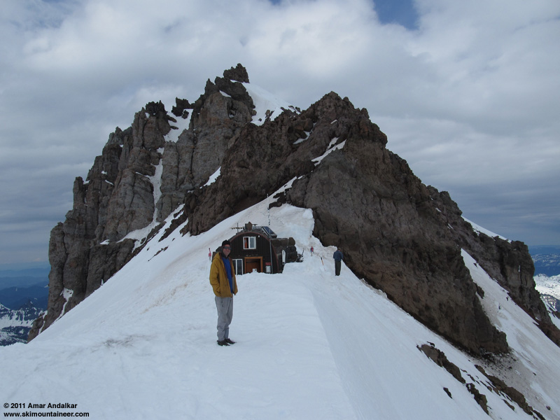
David Gottlieb at the Camp Schurman hut.
We all finally skied out after 5pm, finding deep mushy oversoftened corn on the lower Emmons Glacier. Decent skiing, but not all that great, more fun for some than others. The snow surface was crawling with ice worms coming to the surface in the cooling evening light, with a few dozen per square foot in spots. (More ice worm info: Wikipedia article, North Cascades Glacier Ice Worm research, and Seattle Times article)
Synchronized skiing down the mushy corn of the lower Emmons Glacier.
We exited a somewhat different way than we had come, staying close to the Emmons Moraine and following the ski tracks of a group of Colorado skiers who had exited by following Gottlieb's skin track from the evening before.
Last look back up the Emmons towards the Mountain.
This way eventually required skinning to get up and over the forested part of the moraine and down to the trail bridge across the Inter Fork, with several bare spots to skin across to get there, and a steep eroding slope to descend to reach the river.
Crossing the bridge on the Emmons Moraine Trail, installed in September 2010.
We kept the skins on for the remaining 1 mile and 500 vert of descent back to the parking lot, with several ups and downs along the trail, and bare sections which had gotten even longer since the previous morning, a couple of them long enough to force the skis off our feet. Skied out to the parking lot by 7:30pm, a long and tiring day. We were all stoked though to have skied the entire Emmons Glacier from crater rim to terminus, with two of us completing impressive ski ascents which are much rarer these days on Rainier than summit ski descents. A great way to spend the weekend, thanks to all my partners for coming along and sharing the experience with me!
Morning view of Rainier from SR 410, well worth driving the extra half-mile south of the White River turnoff.
However, adequate snow cover to ski the lower portions of the route (below about 5000 ft) typically exists only during late winter and early spring, but the road to White River does not normally open until just before Memorial Day weekend. Thus skiing the entire glacier usually requires a snowmobile or a multi-day approach, so the route is very rarely skied. But this year, with an exceptional late-spring snowpack at elevations above 4000 ft in the Cascades, would be the best chance in many years to try the route. The crux of the route would be finding a way to cross the Inter Fork of White River safely, since the Glacier Basin Trail stays along the north side while the Emmons lies to the south.

(click for double-size version)
Telephoto view (336 mm lens) from SR 410 showing the Emmons route from Camp Schurman (lower right) to the summit. Note the open bergschrund which completely blocks the standard traverse going right to the 13600 ft saddle, parties will have to ascend directly to the crater rim this year.
A blog post showed that climbing rangers had skied the route on May 2, using the plowed White River road which remained closed to the public. The road was scheduled to open on May 20, then rescheduled for May 27, but the park failed to meet either of those dates, and it finally opened on June 2. Luckily, due to the abnormally cold and wet Northwest spring which brought repeated snowfalls and delayed melting, the snowpack above 4000 ft had barely decreased over the entire month of May. Paradise at 5400 ft on Rainier's south side boasted its 2nd greatest June 1 snowdepth in 91 years of data (213", about 190% of normal), while Crystal Mountain located 15 miles NE of the summit and 8 miles NE of White River Campground still had 88" at its 4480 ft base station on June 1 (over 200% of normal), losing only 19" since May 1 which was mostly due to consolidation.
Even more fortunately, the forecast looked stellar for the first weekend after the road opened: mostly sunny, freezing level 11000-12000 ft. So by Friday evening, I had easily managed to convince a crew of 5 others to join me: Greg, Ryan, Khanh, Tobae, and Tim, all strong ski mountaineers with prior Rainier summits. We planned to leave town early Saturday and arrive at White River Ranger Station by 7am when it opened, in order to register and secure some of the limited number of spots at Camp Schurman in case it was a busy weekend. Climbing ranger David Gottlieb was manning the desk when we arrived, and he was a fount of useful information on the route and especially the approach, having skied it both on May 2 and again a few weeks later. He said that crossing near the end of the newly-built Glacier Basin Trail segment at the junction with the Emmons Moraine Trail would be best (about 1 mile from the trailhead), using either a large log or possibly the log trail bridge on the Emmons Moraine Trail, which had a steep snowbank along its far side. Note that this bridge was finally installed in September 2010 to reopen that trail, almost 4 years after washing out in the November 2006 floods.
We skinned out from the trailhead at 8:30am, carrying glacier gear and two ropes, but no avy gear. Snowdepth at the parking lot was about 4-5 ft, but as we reached the newly-built Glacier Basin Trail segment after a half-mile, there were several short and long bare sections of trail especially on bridges. Although we continued skinning across those, the trail became very bare at the sunny pair of switchbacks, so we continued straight through the woods instead and dropped down to the river bank, eventually finding an acceptable log to cross at about 4800 ft.
Crossing the Inter Fork of White River on a log near 4800 ft.
A short traverse across the Emmons Moraine and minor bushwhacking through the immature young forest brought us out into the open atop the 1963 rockfall avalanche deposit, looking directly at the terminus of the Emmons Glacier and up its entire length to the summit (see first photo above). Just a spectacular place, with an outstanding view of Big Tahoma and Little Tahoma rising above the glacier's trough.
A bright green glacial pond atop the 1963 rockfall avalanche deposit, with Little Tahoma rising above. This pond is currently much larger than the tiny pond shown on the topo map, revealing the likely presence of stagnant glacial ice within the deposit and the moraines buried under it. Melting of this stagnant ice has apparently been enlarging the pond's basin.
From here, the broad open glacier is basically a highway leading directly to Camp Schurman. The glacier's surface was covered with recent new snow above 6000 ft, with only a single faint skin track from sometime several days earlier. Easy travel skinning on a supportive crust, which sat atop 1-2 ft of mushy rounded grains that one could punch a ski pole into.
A welcome downslope breeze kept temperatures tolerable in the blazing sunshine on the glacier, and we enjoyed the remoteness of this route variation. We would see no one else from the parking lot until reaching Camp Schurman. Lots of wet slides from the sunny south slopes of Mount Ruth to our right, but the snow on the glacier was stable and not sluffing or sliding. Crevasses were well buried and not an issue, except a few incipient cracks near 9000 ft where our route joined the standard route descending from Inter Glacier onto the Emmons.
Two-shot panorama looking down the Emmons Glacier from about 8000 ft.
It was almost 4pm by the time we reached Camp Schurman, a fairly tiring haul from the car. A bit chilly there with an easterly breeze. We set up camp in a large vacated site with ample snow-block walls, a MegaLight, a FirstLight, plus two bivy sacks out in the open. After dinner and melting lots of water, we got to bed early, unfortunately missing the sunset which is usually spectacular looking down from the camp at Puget Sound and the Olympics. After much indecision about whether to boot or skin the next day, we had finally planned to leave the next morning in two groups: one team of three heading up at 5am on foot and roped up, the other leaving an hour or two later and hoping that the snow would have softened enough to skin up the entire route. I had only ever successfully skinned the Emmons-Winthrop route once, on an amazing July 2009 trip skiing up and down all three summits. I've cramponed the entire way from Schurman to summit most of the times I've skied this route, as had the others in our group. We had serious doubts whether the route would be skinnable the next day.
[hr">The spectacular rosy colors of sunrise on the Emmons the next morning made up for missing the sunset. Tobae, Khanh, and Tim headed up at sunrise, while Ryan, Greg, and I had just awoken and started getting ready to go. The mountain above was totally clear, but off to the east an unexpected deck of high clouds was looming, enhancing the sunrise but putting snow conditions for skinning in doubt.
The incoming high clouds at sunrise (photo by Khanh Quach).
Our first team heading out from camp.
The three of us finally set out at 6:45am, on skins with ski crampons and wearing harnesses but not roped, with high clouds now mostly obscuring the sun. Despite the lack of intense morning sun, the snow conditions turned out to be excellent for skinning, with solid grip and no slip on the smooth snow beside the typically messy Emmons bootpack.
We took turns breaking trail in broad gentle efficient switchbacks, seeing faint traces of an older much steeper skintrack in places. The clouds thickened ominously overhead, while off to the north it was entirely clear over the central and northern Cascades.
We made rapid progress up to nearly 12000 ft, where we hit the first steeper section between a few partially exposed seracs and crevasses, including a section of exposed blue glacial ice. We considered putting the skis on our backs and roping up, but decided to keep skinning. A pretty good decision, the route was entirely skinnable without any major slips by any of us, although the caution and concentration needed to skin the steeper bits slowed our pace considerably.
Skinning past exposed blue glacial ice near 12000 ft, with a narrow corridor of snow between seracs and crevasses to the right.
The high clouds were moving from east to west, and clearer skies off to the east gave hope that it might clear out. But the cloud deck was now sprouting streamers of virga, and eventually it snowed briefly on us a couple of times.
Yes, it's snowing! Around 10:15am, near 12500 ft, with the terminus of Winthrop Glacier visible nearly 8000 ft below us.
The first open crevasse which needed to be crossed by snowbridge was near 12700 ft, and then the route traversed slightly east to the right edge of the bergschrund at 13000 ft, which required a short section of sidestepping downhill about 5 vertical feet to negotiate.
Greg gingerly sidestepping across the snowbridge at 13000 ft, Ryan photographing.
We had almost caught up to the other three by 13200 ft, I was in the lead setting the skin track only a few yards below them, when suddenly it happened: I looked down and knew instantly that the toepiece had ripped entirely out of my right ski. I couldn't avoid spewing a few obscenities seconds later as the full weight of what this meant hit me. I was screwed. I was clearly not going to complete a full ski ascent of the entire Emmons Glacier. I was probably not going to complete a full ski descent of the entire Emmons Glacier either. I was going to have to walk the rest of the way to the summit, and then most likely have to walk down the entire f***ing Mountain, stumbling and sliding and postholing just like those climbers on foot that ski mountaineers feel so superior to, while my partners would be ripping turns down the whole route in style. *&^%$#@!
Not good: something is missing from one of my skis at 13200 ft, with the 13720 ft summit of Curtis Ridge beyond.
Our team on foot asked what they could do to help, but I told them "nothing", just keep going and we'll figure it out. I put the skis on my back and followed them up the bootpack, while Greg and Ryan kept on skinning. At least Greg was confident that we could remount the binding somehow, enough for me to ski down. The easterly wind was getting stronger and gustier as we climbed, and the cloud deck was looking more and more threatening, although a lenticular was definitely not yet forming.
Our group at 14100 ft, with a random climber curled up in front waiting for his partners to catch up.
We regrouped at about 14100 ft, in a spot slightly sheltered from the wind but almost at the edge of the cloud deck, and considered turning around. But several of us wanted to continue, so we decided to keep going. We reached the rim near 14300 ft just before 1:30pm, to find the wind gusting at 40+ mph, making it hard to stand with skis acting as sails on the pack. In a near whiteout we continued a short distance up along the rim before calling it quits. Ryan and Greg had made it all the way from the parking lot up to here on skins, but it was definitely not worth the discomfort or the risk of continuing along the rim to Columbia Crest, probably still 10 minutes away, when the clouds could fully envelop us at any moment.
Greg and Khanh at our high point on the crater rim, with the rest of the group just a few minutes behind.
We quickly retreated back down to 14100 ft, and Greg and Ryan started helping to remount my toepiece, while the others began their ski descent. It took about 30 minutes to clean out the holes, clean the frozen rotten-wood / epoxy mixture off the screws, and remount the binding in the same holes using my Leatherman tool, then strap it on very tightly to the ski with my two 15" Voile straps. Another five 24" Voile straps from Ryan were used to secure my boot to the ski and binding, which took another 10 minutes. A total of four Voile straps passed under my right ski, making it extremely grippy on any firmer snow -- it was almost impossible to turn left except by jump-turning. I eventually figured out that it was faster and safer to just sideslip the majority of the route with my good left ski downhill, making turns only on the patches of softer powdery snow. The snow was generally firm windpacked powder with sections of softer powder, but luckily there was no ice. If it had been icy, I probably would have needed to crampon down on foot instead of staying on skis.
Finally skiing down at 2:30pm.
It took an exhausting and painful hour-and-half for me to reach Camp Schurman around 4pm, with Greg running sweep uphill of me in case of disaster. The snow softened into mushy corn below 11500 ft on the Emmons Corridor, and I could finally make turns for real, nice ones with the left leg and cautious jerky ones with the right. The toepiece held until camp, but just barely: it had partially ripped out again and was being held on only by the Voile straps, along with the straps holding my boot directly to the ski.
Greg carving turns in the soft corn below the Emmons Corridor.
The rest of the group had already arrived and informed David Gottlieb of our situation (he had also skinned up via the Emmons terminus later on Saturday evening). He offered a cordless drill to help us remount the toepiece, which was an amazing stroke of good fortune. I stood atop the workbench outside the ranger hut with my boot used as a measuring guide, while Ryan and Dave remounted the toepiece about 1cm back, taking advantage of half the 26mm travel of the Vertical FT heel. Done in just about 5 minutes. Thanks for all the help, Dave!
David Gottlieb at the Camp Schurman hut.
We all finally skied out after 5pm, finding deep mushy oversoftened corn on the lower Emmons Glacier. Decent skiing, but not all that great, more fun for some than others. The snow surface was crawling with ice worms coming to the surface in the cooling evening light, with a few dozen per square foot in spots. (More ice worm info: Wikipedia article, North Cascades Glacier Ice Worm research, and Seattle Times article)
Synchronized skiing down the mushy corn of the lower Emmons Glacier.
We exited a somewhat different way than we had come, staying close to the Emmons Moraine and following the ski tracks of a group of Colorado skiers who had exited by following Gottlieb's skin track from the evening before.
Last look back up the Emmons towards the Mountain.
This way eventually required skinning to get up and over the forested part of the moraine and down to the trail bridge across the Inter Fork, with several bare spots to skin across to get there, and a steep eroding slope to descend to reach the river.
Crossing the bridge on the Emmons Moraine Trail, installed in September 2010.
We kept the skins on for the remaining 1 mile and 500 vert of descent back to the parking lot, with several ups and downs along the trail, and bare sections which had gotten even longer since the previous morning, a couple of them long enough to force the skis off our feet. Skied out to the parking lot by 7:30pm, a long and tiring day. We were all stoked though to have skied the entire Emmons Glacier from crater rim to terminus, with two of us completing impressive ski ascents which are much rarer these days on Rainier than summit ski descents. A great way to spend the weekend, thanks to all my partners for coming along and sharing the experience with me!
The forecast we planned on the day before:
MOUNT RAINIER RECREATIONAL FORECAST
NATIONAL WEATHER SERVICE SEATTLE WA
243 PM PDT FRI JUN 3 2011
SYNOPSIS...HIGH PRESSURE WILL BUILD OVER THE AREA TODAY AND CONTINUE THROUGH SUNDAY RESULTING IN A WARMING AND DRYING TREND. AN UPPER TROUGH AND ONSHORE FLOW WILL RETURN NEXT WEEK FOR COOLER AND CLOUDY WEATHER. AN UPPER LOW COULD BRING SOME SHOWERS TUESDAY AND WEDNESDAY.
FRIDAY NIGHT...MOSTLY CLEAR. FREEZING LEVEL 10000 FEET.
SATURDAY...SUNNY. FREEZING LEVEL 11000 FEET.
SATURDAY NIGHT...MOSTLY CLEAR. FREEZING LEVEL 11000 FEET.
SUNDAY...MOSTLY SUNNY. FREEZING LEVEL 12000 FEET.
SUNDAY NIGHT AND MONDAY...MOSTLY CLOUDY. FREEZING LEVEL 10000 FEET.
MONDAY NIGHT...MOSTLY CLOUDY WITH A CHANCE OF SHOWERS. SNOW LEVEL 8000 FEET.
TUESDAY AND TUESDAY NIGHT...MOSTLY CLOUDY. A CHANCE OF SHOWERS. SNOW LEVEL 6500 FEET.
WEDNESDAY AND WEDNESDAY NIGHT...MOSTLY CLOUDY. A CHANCE OF SHOWERS. SNOW LEVEL 5500 FEET.
THURSDAY THROUGH FRIDAY...MOSTLY CLOUDY. FREEZING LEVEL 9000 FEET.
TEMPERATURE AND WIND FORECASTS FOR SELECTED LOCATIONS.
FRI SAT SAT SUN
NIGHT NIGHT
SUMMIT (14411 FT) 13 17 17 15
E 18 E 13 SW 8 SW 11
CAMP MUIR(10188 FT) 31 34 36 34
SE 9 SE 7 SW 11 SW 8
PARADISE (5420 FT) 46 65 46 65
NE 11 SE 12 E 8 N 6
LONGMIRE (2700 FT) 40 72 38 72
NE 10 SE 12 NE 7 NE 6
But then it changed slightly just as we left town:
MOUNT RAINIER RECREATIONAL FORECAST
NATIONAL WEATHER SERVICE SEATTLE WA
400 AM PDT SAT JUN 4 2011
SYNOPSIS...WEAK HIGH PRESSURE WILL BRING SUNSHINE...RATHER LIGHT WINDS...AND MILD TEMPERATURES TO MOUNT RAINIER NATIONAL PARK TODAY. THE PATTERN WILL EXTEND INTO SUNDAY...HOWEVER SHOWER OR THUNDERSTORM ACTIVITY COULD MOVE NORTH OVER THE AREA SUNDAY AFTERNOON AND EVENING. A TRANSITION IN THE WEATHER PATTERN WILL MEAN A RETURN TO MOSTLY CLOUDY WEATHER AND A CHANCE OF SHOWERS MONDAY. AN UPPER LOW WILL TRACK SOUTHEAST ACROSS WASHINGTON TUESDAY FOR SOMEWHAT COOLER WEATHER AND A BETTER CHANCE OF SHOWERS.
SATURDAY...SUNNY. FREEZING LEVEL 11000 FEET.
SATURDAY NIGHT...MOSTLY CLEAR. FREEZING LEVEL 11000 FEET.
SUNDAY...MOSTLY SUNNY IN THE MORNING...THEN MOSTLY CLOUDY WITH A CHANCE OF SHOWERS IN THE AFTERNOON. SNOW LEVEL 10000 FEET.
SUNDAY NIGHT...MOSTLY CLOUDY. A CHANCE OF SHOWERS IN THE EVENING. SNOW LEVEL 10000 FEET.
MONDAY...MOSTLY CLOUDY. A CHANCE OF SHOWERS IN THE AFTERNOON. SNOW LEVEL 9000 FEET.
MONDAY NIGHT...CLOUDY WITH A CHANCE OF SHOWERS. SNOW LEVEL 9000 FEET.
TUESDAY THROUGH WEDNESDAY...MOSTLY CLOUDY. A CHANCE OF SHOWERS. SNOW LEVEL 6000 FEET.
WEDNESDAY NIGHT THROUGH FRIDAY...MOSTLY CLOUDY WITH A CHANCE OF SHOWERS. SNOW LEVEL 7000 FEET.
TEMPERATURE AND WIND FORECASTS FOR SELECTED LOCATIONS.
SAT SAT SUN SUN MON
NIGHT NIGHT
SUMMIT (14411 FT) 18 17 15 14 15
E 20 S 15 SW 15 SW 15 NE 15
CAMP MUIR(10188 FT) 34 37 35 35 34
E 10 SW 10 SW 10 W 10 NE 10
PARADISE (5420 FT) 65 46 65 42 58
E 5 E 5 SW 5 NW 5 NW 10
LONGMIRE (2700 FT) 70 46 70 43 63
CALM CALM CALM CALM CALM
MOUNT RAINIER RECREATIONAL FORECAST
NATIONAL WEATHER SERVICE SEATTLE WA
243 PM PDT FRI JUN 3 2011
SYNOPSIS...HIGH PRESSURE WILL BUILD OVER THE AREA TODAY AND CONTINUE THROUGH SUNDAY RESULTING IN A WARMING AND DRYING TREND. AN UPPER TROUGH AND ONSHORE FLOW WILL RETURN NEXT WEEK FOR COOLER AND CLOUDY WEATHER. AN UPPER LOW COULD BRING SOME SHOWERS TUESDAY AND WEDNESDAY.
FRIDAY NIGHT...MOSTLY CLEAR. FREEZING LEVEL 10000 FEET.
SATURDAY...SUNNY. FREEZING LEVEL 11000 FEET.
SATURDAY NIGHT...MOSTLY CLEAR. FREEZING LEVEL 11000 FEET.
SUNDAY...MOSTLY SUNNY. FREEZING LEVEL 12000 FEET.
SUNDAY NIGHT AND MONDAY...MOSTLY CLOUDY. FREEZING LEVEL 10000 FEET.
MONDAY NIGHT...MOSTLY CLOUDY WITH A CHANCE OF SHOWERS. SNOW LEVEL 8000 FEET.
TUESDAY AND TUESDAY NIGHT...MOSTLY CLOUDY. A CHANCE OF SHOWERS. SNOW LEVEL 6500 FEET.
WEDNESDAY AND WEDNESDAY NIGHT...MOSTLY CLOUDY. A CHANCE OF SHOWERS. SNOW LEVEL 5500 FEET.
THURSDAY THROUGH FRIDAY...MOSTLY CLOUDY. FREEZING LEVEL 9000 FEET.
TEMPERATURE AND WIND FORECASTS FOR SELECTED LOCATIONS.
FRI SAT SAT SUN
NIGHT NIGHT
SUMMIT (14411 FT) 13 17 17 15
E 18 E 13 SW 8 SW 11
CAMP MUIR(10188 FT) 31 34 36 34
SE 9 SE 7 SW 11 SW 8
PARADISE (5420 FT) 46 65 46 65
NE 11 SE 12 E 8 N 6
LONGMIRE (2700 FT) 40 72 38 72
NE 10 SE 12 NE 7 NE 6
But then it changed slightly just as we left town:
MOUNT RAINIER RECREATIONAL FORECAST
NATIONAL WEATHER SERVICE SEATTLE WA
400 AM PDT SAT JUN 4 2011
SYNOPSIS...WEAK HIGH PRESSURE WILL BRING SUNSHINE...RATHER LIGHT WINDS...AND MILD TEMPERATURES TO MOUNT RAINIER NATIONAL PARK TODAY. THE PATTERN WILL EXTEND INTO SUNDAY...HOWEVER SHOWER OR THUNDERSTORM ACTIVITY COULD MOVE NORTH OVER THE AREA SUNDAY AFTERNOON AND EVENING. A TRANSITION IN THE WEATHER PATTERN WILL MEAN A RETURN TO MOSTLY CLOUDY WEATHER AND A CHANCE OF SHOWERS MONDAY. AN UPPER LOW WILL TRACK SOUTHEAST ACROSS WASHINGTON TUESDAY FOR SOMEWHAT COOLER WEATHER AND A BETTER CHANCE OF SHOWERS.
SATURDAY...SUNNY. FREEZING LEVEL 11000 FEET.
SATURDAY NIGHT...MOSTLY CLEAR. FREEZING LEVEL 11000 FEET.
SUNDAY...MOSTLY SUNNY IN THE MORNING...THEN MOSTLY CLOUDY WITH A CHANCE OF SHOWERS IN THE AFTERNOON. SNOW LEVEL 10000 FEET.
SUNDAY NIGHT...MOSTLY CLOUDY. A CHANCE OF SHOWERS IN THE EVENING. SNOW LEVEL 10000 FEET.
MONDAY...MOSTLY CLOUDY. A CHANCE OF SHOWERS IN THE AFTERNOON. SNOW LEVEL 9000 FEET.
MONDAY NIGHT...CLOUDY WITH A CHANCE OF SHOWERS. SNOW LEVEL 9000 FEET.
TUESDAY THROUGH WEDNESDAY...MOSTLY CLOUDY. A CHANCE OF SHOWERS. SNOW LEVEL 6000 FEET.
WEDNESDAY NIGHT THROUGH FRIDAY...MOSTLY CLOUDY WITH A CHANCE OF SHOWERS. SNOW LEVEL 7000 FEET.
TEMPERATURE AND WIND FORECASTS FOR SELECTED LOCATIONS.
SAT SAT SUN SUN MON
NIGHT NIGHT
SUMMIT (14411 FT) 18 17 15 14 15
E 20 S 15 SW 15 SW 15 NE 15
CAMP MUIR(10188 FT) 34 37 35 35 34
E 10 SW 10 SW 10 W 10 NE 10
PARADISE (5420 FT) 65 46 65 42 58
E 5 E 5 SW 5 NW 5 NW 10
LONGMIRE (2700 FT) 70 46 70 43 63
CALM CALM CALM CALM CALM
Amar
Excellent job ,Over the top, I had to catch my breath there a few times. With the saftey strap you only had the toe piece. Lucky the ski didn't take off.
I'd say you skied it up and down .
I'd better check my rig cause it's exact same as yours. cept I use Gorilla glue.
keep going!
Excellent job ,Over the top, I had to catch my breath there a few times. With the saftey strap you only had the toe piece. Lucky the ski didn't take off.
I'd say you skied it up and down .
I'd better check my rig cause it's exact same as yours. cept I use Gorilla glue.
keep going!
Nice job with a binding fix Amar! You are ready to be a tele skier.
Good to see that Ryan had the right hat for the job too. Nice trip to all of you.
Mike
Good to see that Ryan had the right hat for the job too. Nice trip to all of you.
Mike
Very impressive piece of work to all. Very nice report Amar. I had just mentioned to Lowell the other day how there have been an impressive number of creative ski routes on Rainier lately. Thanks for all the beta on the trip and the conditions of getting from the lower trail. Based on your experience would the GB trail have continuous snow to the Interglacier? At first looking at the pictures I thought you carried a cordless drill with you, but after reading it was pretty fortunate to have that at Sherman.
It amazes me how much snow is still up on the lower hills seen from your photos.
So what next, the Willis Wall?
It amazes me how much snow is still up on the lower hills seen from your photos.
So what next, the Willis Wall?
Great trip everyone! Glad you got to ski the whole Emmons!
Nice summary Amar. But you forgot to mention the best part of the trip. It was Tobae's birthday on saturday! She didn't mention her age, but based upon her fitness, skiing ability, and overall sense of adventure, I'd guess low to mid 30's. Birthday tours are always a good time.
I posted my own version of trip, along with some video footage of the crux super tense moments here:
http://skisickness.com/post/viewtopic.php?f=3&t=238
I posted my own version of trip, along with some video footage of the crux super tense moments here:
http://skisickness.com/post/viewtopic.php?f=3&t=238
great write up Amar.
Joe, I went up IG on Sunday and the new trail stays annoyingly high above the river and on a more sun exposed slope that was melted out about a mile from the trail head. We dropped down to the river ~4700 ft to avoid the annoying skis on, skis off and had continuous snow from there into glacier basin. With a couple of creative moves on the way out we were able to ski all but ~50 ft on the way out, but several spots weren't going to last much longer.
author=Joedabaker link=topic=21086.msg90180#msg90180 date=1307547689]
Based on your experience would the GB trail have continuous snow to the Interglacier?
Joe, I went up IG on Sunday and the new trail stays annoyingly high above the river and on a more sun exposed slope that was melted out about a mile from the trail head. We dropped down to the river ~4700 ft to avoid the annoying skis on, skis off and had continuous snow from there into glacier basin. With a couple of creative moves on the way out we were able to ski all but ~50 ft on the way out, but several spots weren't going to last much longer.
Very entertaining read. Way to turn a diseaster into a tolerable situation. Great job.
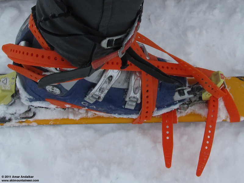
cool trip guys! that picture of Amar's boot looks like it belongs in an advertisement for Voile
Nice idea, Amar! Glad you guys all pulled off a great trip.
Very nice work.
Thanks for the report and thanks to the crew for nailing it.
Thanks for the report and thanks to the crew for nailing it.
What a great trip even with equipment issues. BTW, when you were skiining up high, did you use ski crampons (I know, what other kinds are there..)? Hinged or fixed?
Ski crampons were essential this time for skinning up above about 10500 ft, as there were many sections of firm snow which would have been extremely sketchy without them (we would have cramponed on foot if we had no ski crampons). The three of us who skinned the upper mountain used three different types of ski crampons, all hinged: Dynafit for me, B & D Gear for Ryan (we both used Dynafit bindings), and Marker Dukes with their matching crampons for Greg.
All six of us brought ski crampons on this trip, which may be the first time I've ever been on a trip in a group larger than 2 where everyone had them. Several of my regular ski partners simply refuse to get ski crampons, and my long-term efforts to get them to see the light have mostly been futile -- a few others have finally given in and bought ski crampons, but still don't actually bring them on most trips. I think that once you have them, it's pretty much essential to bring them on every trip which is not a deep-powder winter trip, because you never know when you'll need them, and their weight is negligible. The amount of effort they save in certain conditions is huge (think of a firm frozen morning crust which is supportable on skis, but breakable on foot with deep postholing into the softer snow under the crust). Plus, skinning up is so much more elegant and more fun than slogging up on foot with extra weight on your pack.
I bought ski crampons within a few months after buying my first AT setup in 1996 (Fritschi bindings and crampons back then), and have used them consistently in appropriate conditions throughout all these years. Hinged crampons have always worked well enough for me, I've never used the fixed type.
Great TR Amar and I love, love, love the MacGyver binding fix -- excellent work to all involved. I'd love to see closer pics or hear more details about its construction.
author=ryanl link=topic=21086.msg90187#msg90187 date=1307552236]
Nice summary Amar. But you forgot to mention the best part of the trip. It was Tobae's birthday on saturday! She didn't mention her age, but based upon her fitness, skiing ability, and overall sense of adventure, I'd guess low to mid 30's. Birthday tours are always a good time.
Flattery will get you everywhere Ryan-
A great trip in an amazing place.
Great trip report Amar and Ryan!! Glad you guys were able to fix the binding for the descent, what a fiasco it may have otherwise been.
author=Marcus link=topic=21086.msg90215#msg90215 date=1307567516]
Great TR Amar and I love, love, love the MacGyver binding fix -- excellent work to all involved. I'd love to see closer pics or hear more details about its construction.
Greg Blaisdell (orthopedic surgeon, and apparently ski surgeon too) was responsible for most of the repair work at 14100 ft, with Ryan and me helping a bit. The toepiece was remounted in the same holes simply by overtightening the screws (after cleaning the threads thoroughly), which surprisingly made it almost solidly attached. Two 15" Voile straps were cranked down very tightly over the front and back of the toepiece to keep it in place.
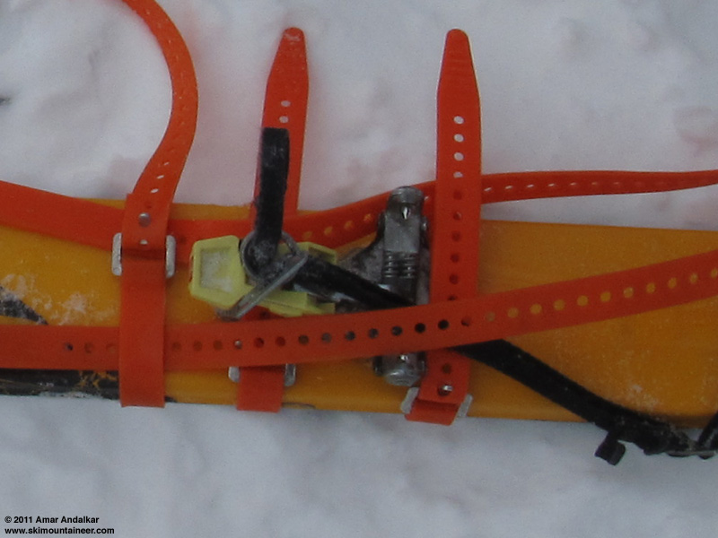
A single 24" Voile strap was wrapped around the boot and ski over the instep just in front of the buckles (it could have gone in between the two buckles also), which pretty much solidly held the toe down onto the ski. The other 24" straps were used to wrap around the back of the boot and attach to a strap going under the ski just in front of the toepiece, to keep more downward force on the toepiece.
It might be useful to start bringing some underwater marine epoxy (or epoxy putty) on trips, which probably would have resulted in a solid bond of the screws in the holes. But I already carry too many emergency supplies, far more than most anyone I ski with, so I'm not sure if I'll bring something like that which might only get used once in a 10-20 year period.
Great fix. Voile straps, once again, prove their utility.
I often carry some kind of epoxy on long trips/hut trips, etc, but I think the utility in the field, if you don't have a clean, dry place and some curing time, can be pretty minimal. Mechanical solutions like this one seem to be the most likely to work out. I've got a bunch of voile straps, some bailing wire and a some stout wire ties as the bulk of my repair kit and it's gotten the job done several times. Not elegant maybe, but effective.
Thanks for the pictures... love that stuff.
Just curious from the pics- why leashes AND brakes?
I've always used both leashes and brakes on all of my ski-mountaineering AT skis since I first started. My two powder-skiing AT skis (Megawatts and Stokes) are brakes only, no leashes, for avy concerns.
The leashes prevent losing the ski in situations where you just can't afford to have it take off on its own (remote places, steeps, glaciers, etc). Brakes make it much easier to put the skis on in sketchy situations (steep, exposed, icy, narrow, etc.) at the start of a descent. They also have the side benefit of letting me use the skis inbounds at ski areas if I wish without needing the straps (I never ski at ski areas without any retention devices like some people do, that's dangerous and illegal and potentially a huge personal liability issue if your ski takes off and hits someone).
The leashes prevent losing the ski in situations where you just can't afford to have it take off on its own (remote places, steeps, glaciers, etc). Brakes make it much easier to put the skis on in sketchy situations (steep, exposed, icy, narrow, etc.) at the start of a descent. They also have the side benefit of letting me use the skis inbounds at ski areas if I wish without needing the straps (I never ski at ski areas without any retention devices like some people do, that's dangerous and illegal and potentially a huge personal liability issue if your ski takes off and hits someone).
Time for some new skis Amar! :D
Those skis are done (K2 Baker Superlight bought in March 2008). Given the water damage to the wood core, I could never rely on them again in the conditions that I need them for (steeps, crevassed glaciers, etc). They've been retired, with 148 days including 7 Rainier summit ski descents, 9 of Baker, 1 Adams, 1 Hood, and 2 Shasta, among many other memorable days in the mountains. An excellent and versatile pair of skis, great in powder and glop, yet capable of holding an edge on ice and carving a beautiful turn on frozen hardpack. It was fitting that their last two trips were descents of Baker and Rainier, so they went out in style.
In addition to the ski damage, the baseplate under the toepiece cracked in two at the ski-crampon slot as it pulled off the ski (both the plastic and fiberglass parts of the Vertical FT toepiece base cracked). I called Salewa in Boulder on Monday morning, and they agreed to ship out a replacement at no cost (an entire toepiece assembly). It was supposed to arrive by Friday, but did not. Not sure when it will get here. I could also mount the toepieces on Vertical ST baseplates, which are wider and better support the pincer wings which hang far past the narrow FT baseplate (there is a retrofit part for the FT toe now which addresses this issue too, the Dynafit Power Plate).
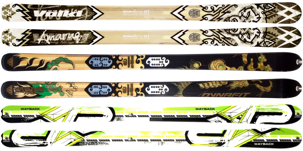
I'm planning to buy some new skis to mount those bindings on: the new Volkl Amaruq looks like a winner, with dimensions essentially identical to the damaged K2 Baker Superlight when placed base-to-base (125-88-108), and a measured weight which is 5 oz lighter per ski at 3 lbs 1.5 oz (1405 g) in 177 cm, very surprising given how light the Baker Superlight is. Plus I would have my name written right on the skis, sort of ("amaruq" means wolf in the Inuit languages, from which Volkl is deriving the names of its entire line of new lightweight backcountry skis introduced in 2010-11 and expanding with several more models for 2011-12). However, I've never had a chance to demo the Amaruq, although I've owned 4 pairs of Volkls over the years and loved each of them, so I'd probably love these also.
The Dynafit Mustagh Ata Superlight is a strong contender too, which has a published weight of 2 lbs 15 oz (1335 g) per ski at 178 cm with dimensions of 122-88-111, and which I've demoed at the 2010 Marmot demo finding that it carves excellent turns on icy hard snow at Summit West. But I'm not sure if the published weight is really true: given the published weights of 1255 g at 169 cam and 1490 g at 187 cm, the 178 cm length should be closer to 1375 g (3 lbs 0.5 oz) per ski, which is almost the same as the Amaruq. Plus getting something with identical dimensions to the Baker Superlight has the big advantage that my current skins will fit perfectly, without having to re-trim the front section and leave extra base exposed near the back as I would need to fit the Mustagh Ata. Not to mention being restricted to 88mm waist skis so that my 90mm Dynafit ski crampons will fit, which rules out the very-popular Manaslu whose 95mm waist would require both new skins and new ski crampons.
Obviously there's the K2 Wayback also, which is the successor to the Baker Superlight with identical dimensions, weight, and internal construction, plus a bit of tip rocker added this year.
Any other suggestions for ultralight skis which are very close to 125-88-108 at about 177 cm length are welcome. Thanks.
In addition to the ski damage, the baseplate under the toepiece cracked in two at the ski-crampon slot as it pulled off the ski (both the plastic and fiberglass parts of the Vertical FT toepiece base cracked). I called Salewa in Boulder on Monday morning, and they agreed to ship out a replacement at no cost (an entire toepiece assembly). It was supposed to arrive by Friday, but did not. Not sure when it will get here. I could also mount the toepieces on Vertical ST baseplates, which are wider and better support the pincer wings which hang far past the narrow FT baseplate (there is a retrofit part for the FT toe now which addresses this issue too, the Dynafit Power Plate).
I'm planning to buy some new skis to mount those bindings on: the new Volkl Amaruq looks like a winner, with dimensions essentially identical to the damaged K2 Baker Superlight when placed base-to-base (125-88-108), and a measured weight which is 5 oz lighter per ski at 3 lbs 1.5 oz (1405 g) in 177 cm, very surprising given how light the Baker Superlight is. Plus I would have my name written right on the skis, sort of ("amaruq" means wolf in the Inuit languages, from which Volkl is deriving the names of its entire line of new lightweight backcountry skis introduced in 2010-11 and expanding with several more models for 2011-12). However, I've never had a chance to demo the Amaruq, although I've owned 4 pairs of Volkls over the years and loved each of them, so I'd probably love these also.
The Dynafit Mustagh Ata Superlight is a strong contender too, which has a published weight of 2 lbs 15 oz (1335 g) per ski at 178 cm with dimensions of 122-88-111, and which I've demoed at the 2010 Marmot demo finding that it carves excellent turns on icy hard snow at Summit West. But I'm not sure if the published weight is really true: given the published weights of 1255 g at 169 cam and 1490 g at 187 cm, the 178 cm length should be closer to 1375 g (3 lbs 0.5 oz) per ski, which is almost the same as the Amaruq. Plus getting something with identical dimensions to the Baker Superlight has the big advantage that my current skins will fit perfectly, without having to re-trim the front section and leave extra base exposed near the back as I would need to fit the Mustagh Ata. Not to mention being restricted to 88mm waist skis so that my 90mm Dynafit ski crampons will fit, which rules out the very-popular Manaslu whose 95mm waist would require both new skins and new ski crampons.
Obviously there's the K2 Wayback also, which is the successor to the Baker Superlight with identical dimensions, weight, and internal construction, plus a bit of tip rocker added this year.
Any other suggestions for ultralight skis which are very close to 125-88-108 at about 177 cm length are welcome. Thanks.
Amar, I've been really happy with my BD Aspects. Wider than the Shuksans but just as easy to turn. The specs are very similar to your Superlights.
Well, the free replacement parts from Salewa finally arrived on Tuesday June 14 via US postal service (8 days after I called Salewa). It turned out to be a pair of Vertical FT front baseplates instead of a single complete toepiece assembly as I'd been told on the phone, but the baseplate is exactly what I needed, so it was fine (even though not arriving by last Friday as expected).
I decided to go ahead today and buy the Volkl Amaruq (127-88-109, 177 cm) which were available locally in the right length (unlike the Mustagh Ata, Wayback, or Aspect), on sale at Marmot in Bellevue. Got my Vertical FTs mounted on them, using both new front baseplates and also getting the Dynafit Power Plates installed just in case. Marmot normally does their mounts with waterproof wood glue on the screws, so I went with that. Excellent service from them, skis mounted while I waited and binding heelpieces thoroughly cleaned out and relubricated too (including on a 2nd pair of skis I brought in, my older 104-70-92 177 cm Volkl Mountain Norbert Joos purchased at Marmot several years ago). Thanks for all your help Eric!
The weight of the entire setup including brakes and straps is 8 lbs 14 oz (4030 g), a savings of 7 oz (200 g) over the nearly-identically sized K2 Mt Baker Superlight which they replaced. Also only 9 oz (250 g) more than my Volkl Mountain Norbert Joos with Dynafit Comforts, which is amazing considering that the Norbert Joos is a very lightweight ski and the Amaruq is 25% wider.
Here's a photo comparing the new Volkl Amaruq with the old Baker Superlight (including extra holes from the field-remount at Camp Schurman):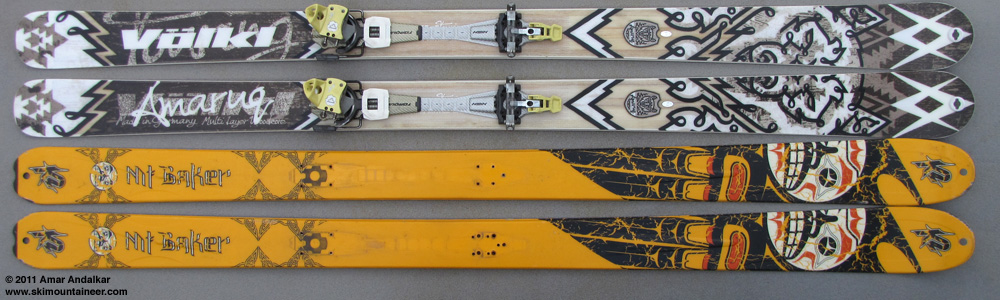
I can't decide which topsheet is scarier. Thanks for the tr, Amar.
Way to go Amar! If I didn't already have 7Summits, Volkl Snowwolfs (I'm going to swap out the tele bindings for Dynafits), and Manaslus, I think that Amaruq would be on my list, big time.
Unfortunately my 7Summits and Snowwolfs are identical in lateral dimensions (the 7s are 178 and the Wolfs 184), I bought the Summits to try out AT and now I don't use the Wolfs; but no one seems to want to buy either (I've advertised both).
Unfortunately my 7Summits and Snowwolfs are identical in lateral dimensions (the 7s are 178 and the Wolfs 184), I bought the Summits to try out AT and now I don't use the Wolfs; but no one seems to want to buy either (I've advertised both).
Reply to this TR
Please login first: